Explore the history, culture, people and beautiful landscapes of Vietnam on the 63Stravel travel app
Download the 63stravel app


Lai Chau 517 view

Download the 63Stravel app to immerse yourself in countless beautiful photos of Vietnam
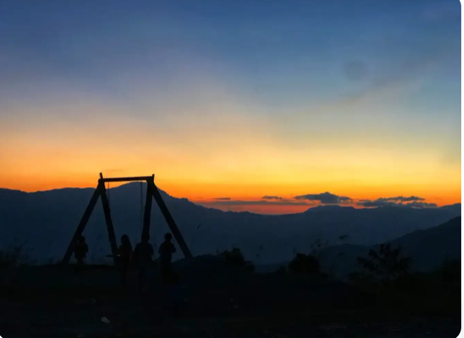
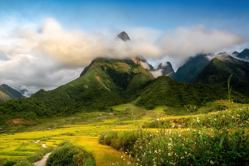
Sunset at Si Thau Chai village
The morning in the village is clear and cool
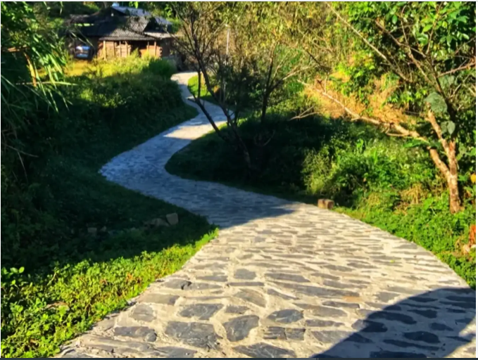
The roads around the village are paved with such beautiful stones
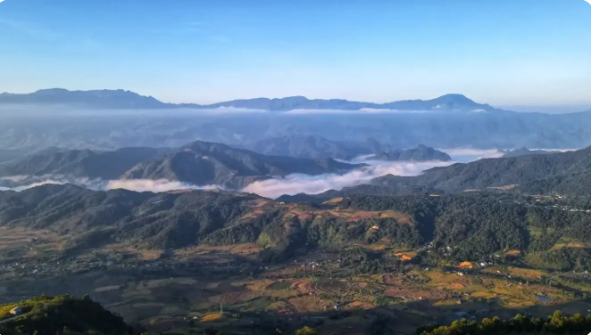
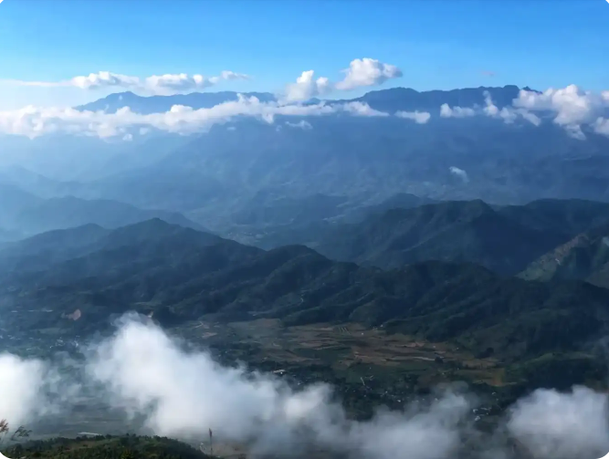
View from Si Thau Chai village down to Tam Duong town
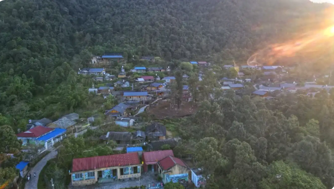
Si Thau Chai village seen from above
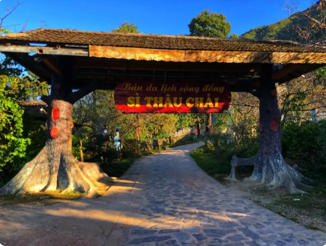
Welcome gate to Si Thau Chai village


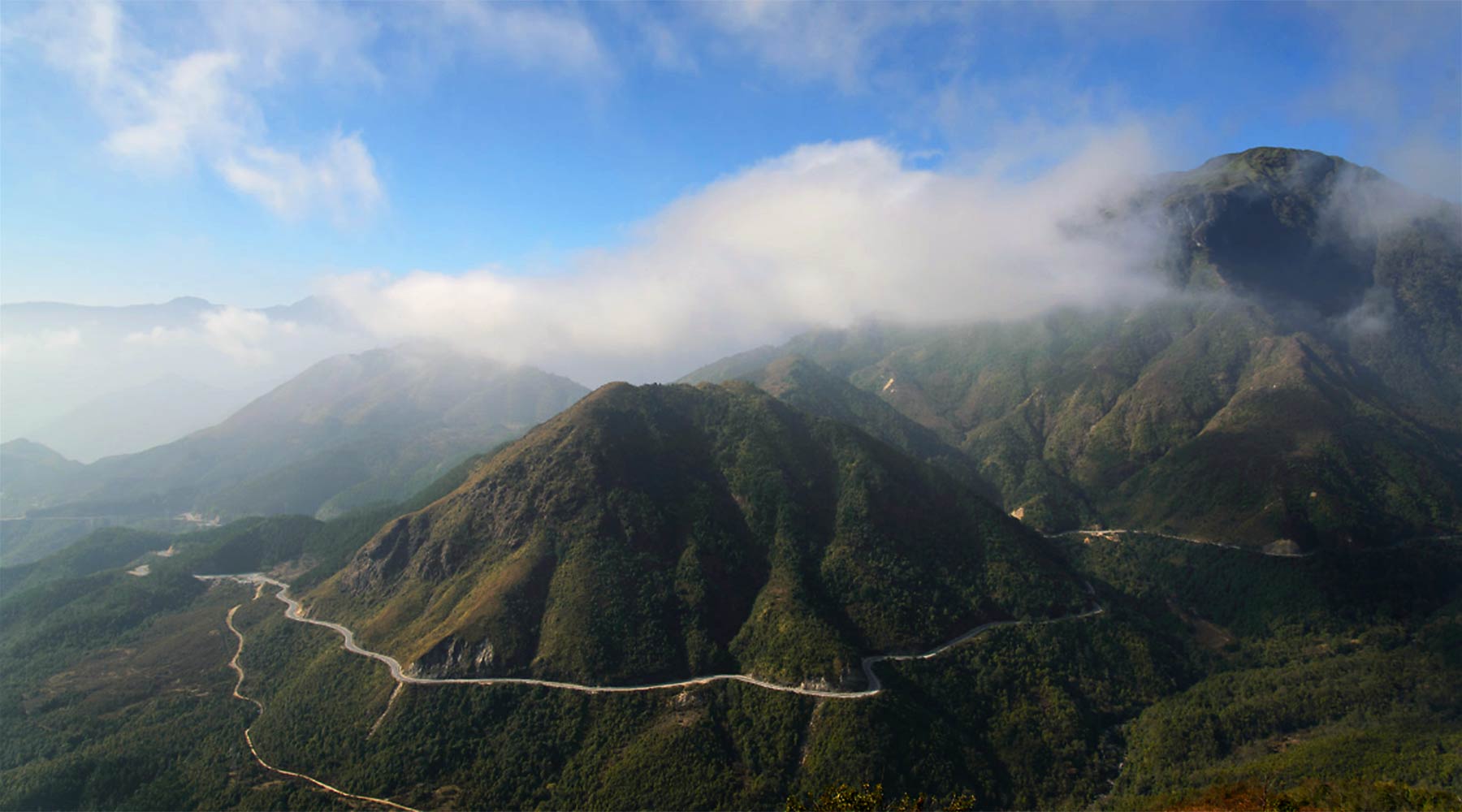
Backpackers often joke that if they haven't reached O Quy Ho Pass, they can't be called genuine backpackers. O Quy Ho Pass has a length of more than 40km, located at an altitude of over 2000 meters, on National Highway 4D crossing Hoang Lien Son range, the top of the pass is the border between Lai Chau and Lao Cai provinces. According to the legend of O Quy Ho Pass, in the past, in this mountainous area, there often appeared a bird with a melodious cry, associated with the legend of the uncoupled love story of a couple. Therefore, over time, it was the cry of that bird that gave the name of this famous pass. For every person traveling O Quy Ho Pass, going down the pass on clear, sunny days is a blessing in life. Standing on the top of the pass, admiring the vast and majestic beauty of the mountain and forest nature, feel the magic of the scenery on the pass: on the Lao Cai side, the fog spreads, on the Lai Chau side, it is sunny and sunny. Summer is often covered with clouds, winter has snow and ice, attracting not only domestic tourists but also foreign tourists. O Quy Ho Pass runs along the slopes of Hoang Lien Son range, a long road with majestic and impressive mountain and forest scenery. On clear, sunny and windy days, you can see small villages in the distance, undulating mountains and the majestic beauty of Fansipan peak amid the clouds. On cold winter days, O Quy Ho has incredible beauty, with snow covering the forest trees and roads. The most ideal journey is from Sapa to O Quy Ho pass, about 12km past Silver Waterfall - one of the most beautiful waterfalls in Lao Cai. In particular, when conquering the pass, backpackers rarely miss Tram Ton - the ranger station of Hoang Lien National Park. This is also one of the starting points to conquer the majestic Fansipan peak and the road to visit Love Waterfall. Here, with the scenery of a cliff on one side and a deep abyss on the other, it creates a feeling of challenge for every driver when passing here. Under the dense tropical forests, a winding road, climbing on cliffs with steep downhills and sharp turns will be a challenge for any driver. However, O Quy Ho Pass has become an important road, a bridge connecting the lowlands to the town center. But this same danger is one of the attractive reasons that attract backpackers to O Quy Ho to experience and surpass themselves.
Lai Chau 1924 view
From January to December
Sin Ho Plateau is a highland district of Lai Chau, this place is considered the second Sapa of the Northwest region. Because the climate here is cool all year round, the average temperature fluctuates around 18 degrees Celsius. The plateau is located in a quite favorable location, located in the middle of rolling rocky mountains, surrounded by green primeval forests. , blending with the sea of floating clouds, creating a scene like a fairyland. Tourists arriving in Sin Ho not only have the opportunity to see the sea of clouds, explore majestic mountain ranges, or visit unique terraced fields, but they also learn about customs and culture. Lai Chau's transformation is also interesting. As a famous tourist destination, you can come here anytime. Because each time in the Sin Ho plateau has its own unique beauty and experiences. If you want to explore fresh natural beauty, with peach blossom forests, plum blossoms,... in full bloom, you can visit in spring. Summer is the ideal time to explore the beauty of the ripe rice season, the terraced fields look like they are wearing a beautiful golden shirt. Or autumn is the time when the air is slightly cool, which is the right time to conquer the surrounding mountains. Winter is the time for you to have the opportunity to watch snow fall on the plateau, which is also very interesting. Where is Sin Ho Plateau located? It is known that this plateau is one of the most famous tourist destinations in Lai Chau, located in Sin Ho district, about 60km from the city center and located at an altitude of about 1,500m. Therefore, getting here is not easy, especially for those who do not have experience traveling to forests and mountains. So what is the road to Sin Ho plateau like? If from Hanoi, first you need to travel to Lai Chau by bus or motorbike (if you are a backpacker). By motorbike, you can follow the route: Hanoi -> Lao Cai -> Sapa -> O Quy Ho Pass -> Lai Chau. Or you can also follow the route: Hanoi -> Phu Tho -> Yen Bai -> Mu Cang Trai -> Lai Chau. After arriving in Lai Chau city center, you can rent a motorbike at hotels or Homestays to stay and conquer the plateau yourself. Not only is it known as an attractive natural tourist destination, but Sin Ho is also a land that preserves the long-standing cultural and historical values of the Vietnamese people. When you arrive at the plateau, before your eyes will be majestic mountains, surrounded by a sea of clouds, dense forests, and winding passes, all creating a unique beauty of the land of Lai Chau that is not typical of Lai Chau. everywhere. The nature here, imbued with the characteristics of primeval forests and mountains, creates wild and majestic beauty. On beautiful days, holidays or weekends, the number of visitors coming to hunt clouds is very large. A scene of floating clouds, stretching endlessly, in the distance are rays of sunlight shining through the trees, causing the clouds to gradually fade. All these images paint a romantic, extremely impressive picture of nature. Sin Ho Lai Chau Plateau is the living and working place of many ethnic minorities, typically: H'Mong people, Thai people, Dao people,... After discovering the beauty of the plateau , visitors can go to the villages to immerse themselves in the simple, rustic life here and learn about the cultural beauty and unique customs of the Sin Ho people. Along with that, you can also enjoy many delicious dishes and Lai Chau specialties, as well as buy ideal souvenirs to give to friends and relatives.
Lai Chau 1876 view
From January to December
From Sa Pa, follow Highway 4D towards Lai Chau for about 30 km, visitors will reach the foot of Chu Va mountain. Chu Va is a new tourist destination, but it is attractive to tourists who like to explore and take photos because when coming here, visitors can be creative in every moment because of the virtual changes of mountain clouds. Chu Va peak stands tall like a sharp arrow reaching high into the sky, that's why this place is like a "navel" of cumulus clouds. Depending on the time, weather, and light changes during the day, Chu Va turns virtual and captivating with many nuances. To reach this mountain range, you have to walk about 1 km from the main road. According to some photographers, taking beautiful photos in Chu Va depends on many factors, but the most beautiful is when the clouds wrap around the mountain body, which photographers call "Scarf Ring". only revealing the mountain amidst the vastness of heaven and earth. The most beautiful season in Chu Va is around the beginning of September, when the terraced fields turn golden yellow surrounding the foot of the mountain, creating a colorful picture. The strangeness and excitement of Chu Va makes many people who love to explore and eyes that want to capture beautiful scenery in their lenses come here to admire and enjoy.
Lai Chau 1860 view
September to March
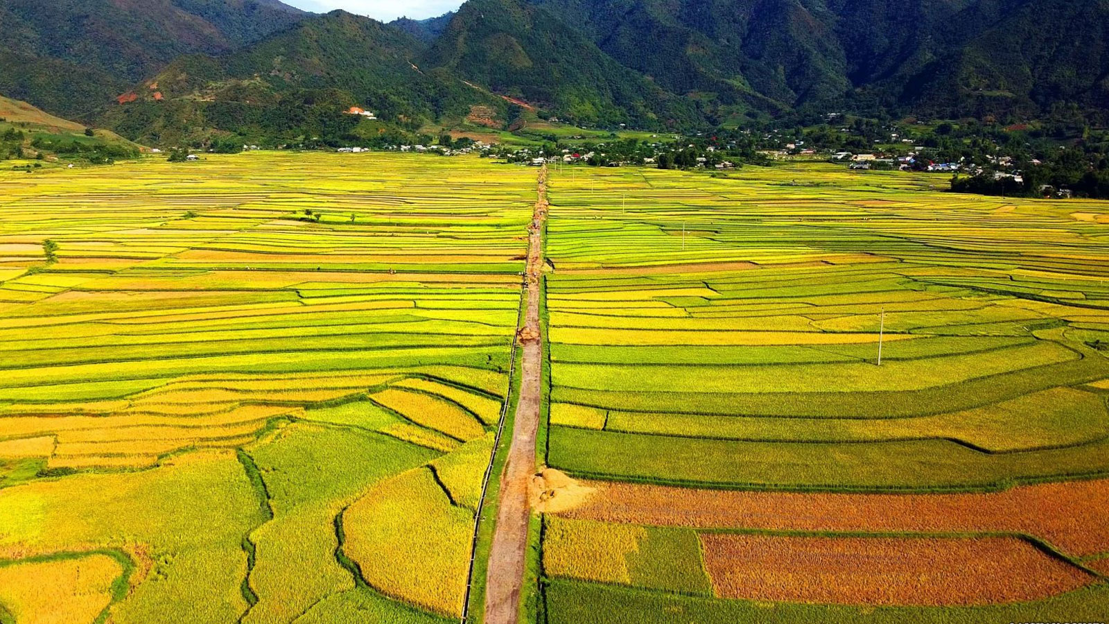
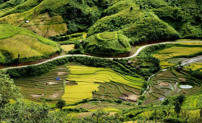
"First Thanh, second Lo, third Than, fourth Tac" is the summary sentence of our ancestors talking about the most vast and beautiful fields in the Northwest. Having just vaguely heard the story of "Than Uyen wind", the temperament of a person who likes to "travel" was eager to cross Highway 32 from Mu Cang Chai (Yen Bai) to Than Uyen (Lai Chau) on a rainy afternoon. sunny winter. Than Uyen district capital is located in a valley, and the valley is a vast, rolling field. Coming to Than Uyen, you will be immersed in a rustic indigenous life of brocade weaving. The scenery and delicious dishes keep attracting visitors from far away. Fish pa deck, it's a dish you can find and enjoy anywhere, from a small restaurant in town or in a lovely stilt house of the Thai people. It is an ancient Thai dish, but is still famous today. To "carve" this unique and unique cuisine, people have to go to the Nam Mu river to catch fish called pa patch in Thai. The fish is cleaned, then mixed with ginger, salt, chili, garlic, wine, especially fragrant roasted sticky rice... mixed well. After being marinated, the fish is placed in a sealed tube of apricot shoots and waited for half a month until the salt is absorbed and can be used. When eating, put the fish on charcoal and grill it, which is called taking the heat from the fire to give it a smoky flavor. Grilled fish eaten with fragrant sticky rice will make the taste buds unforgettable. This season, relax in the fields of Muong Than, the rhythm of working life is full of charming colors. We walked slowly on the endless green fields, as if lost in the vast steppe in a fairy tale. Occasionally the wind rushes into the basin, creating a rather special microclimate on the third most beautiful field in the Northwest. Therefore, "Than Uyen wind" is also a "specialty" of this valley. The wind whistles strongly, swirling around the basin. This season the wind is dry and dry. Tourists who want to explore Than Uyen often go to Muong Cang commune, through Muong Mit commune to see the stilt houses of the Thai people looming in the brilliant color of azalea flowers on the mountainside. What makes us excited is not only the fairy tale scene but also the image of a Thai woman working diligently at the loom. Thai women in Muong Cang commune are busy this season weaving towels and cushions for their families, especially unmarried girls who have to diligently weave day and night to prepare for the happy season when Tet comes and spring comes. about.
Lai Chau 1805 view
From January to December
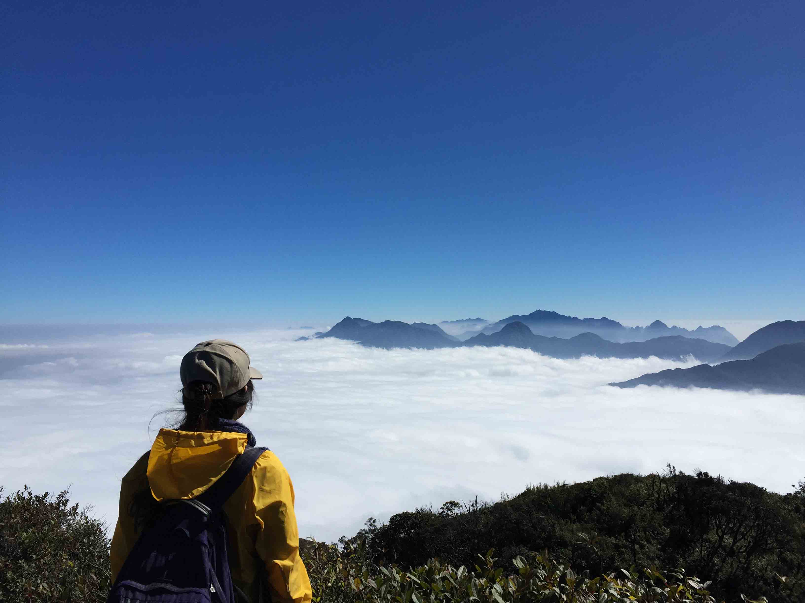
Pu Ta Leng mountain peak with an altitude of 3049m in Lai Chau province is considered a common dream for those who love to travel and are passionate about exploring and discovering. Coming to the second highest mountain peak in Vietnam (only after Fansipan peak), you will be overwhelmed by the majestic and majestic mountains and forests mixed with a bit of magic. The area around the mountain has steep terrain, full of dangers and quite picky with people, however Pu Ta Leng is definitely a worthy gift, an unforgettable experience for youth when deciding to conquer the second roof of the mountain. This Indochina! As one of the mountains in the Hoang Lien Son range, Pu Ta Leng is located just northwest of Fansipan peak. If Fansipan is considered the "roof of Indochina", then Pu Ta Leng is the second roof that backpackers or young people who love challenges "must" try to conquer even just once. Between these two peaks is O Quy Ho Pass (also known as Hoang Lien Pass) and National Highway 4D runs through (this is the road from Lao Cai to Lai Chau and vice versa). Pu Ta Leng peak (Phu Ta Leng) is read in the language of the Dao ethnic people living in Phong Tho district, Lai Chau province as Pu Ta Leng, in which the word "Pú" means "mountain". Conquering Pu Ta Leng is not an overnight event, usually the process of climbing to the top and getting back down will take about 3-4 days. If you want to stop and combine camping along the way and rest a lot, it will take about 3-4 days. from 5-6 days. You can start at the starting line from Pho village, Ho Thau commune, Tam Duong district, Lai Chau province to start your journey to conquer the Pu Ta Leng challenge. With a "respectable" height just behind Fansipan, the 3049m Pu Ta Leng peak is conquered by backpackers who divide their journey into smaller pieces. The first day, from the starting point (the foot of the mountain) climb to an altitude of about 1500-2000m, the second day conquer the remaining altitude, and so continue to repeat the journey when going down from the top, returning to the point. initial departure. Unlike Fansipan peak, which has been upgraded and built with many convenient services for the climbing industry for commercial and tourist purposes, Pu Ta Leng peak is still quite wild, with a rugged mountainous landscape with steep, challenging slopes. Awaken courage, calmness as well as quick thinking in handling unexpected situations. In the first 700-1000m, the road up is not too dangerous, with few turns and jagged cliffs, but dense forest trees block most of the path. Large trees that are thousands of years old, have large rough trunks, and roots that protrude from the ground and lie scattered after a rainstorm or strong wind are also considered one of the significant obstacles that consume time and energy for climbers. From an altitude of 1500m or more, colorful azalea flowers bloom all over the sky of Pu Ta Leng, creating a picture of majestic mountains and forests that still shines with romance and poetry. At most, pink and purple rhododendrons crept across the path, fallen petals littering the path, creating a scene like the road to a fairyland. From here, looking far away we can also see Bach Moc Luong Tu peak and Phu Xi Lung peak, two peaks of the Hoang Lien Son range. Climbing to a height of 3049m, looking down from the top is a feeling of pride in having overcome hundreds, thousands of challenges along the way to conquer the second highest peak in Vietnam. At this altitude, the temperature drops, the weather becomes cold, the air is thin and the climbing path is arduous, easily making the hiker tired. So, take some time to sit down and gather to share your feelings and joys with your group members. In addition to the majestic Pu Ta Leng peak, you can also take this opportunity to explore Bach Moc Luong Tu and Phu Xi Lung peaks... these are all peaks that challenge climbers with sharp, jagged rock slopes. and uneven terrain with many hills and obstacles. Pu Ta Leng in general and the peaks of the Hoang Lien Son range are always a common dream for young people who are passionate about traveling and want to mark unforgettable moments of their youth with conquering feet.
Lai Chau 1784 view
From January to December
Ta Lien Son is beautiful because of its diverse primeval vegetation, luxuriant ancient trees, large trunks covered with moss and ferns. The path is "carpeted" with white ancient camellia flowers, bright red maple leaves mixed with green moss and attractive colorful azalea flowers falling all over the path. The vines clinging tightly to the rock looked like the tentacles of a strange animal, ready to reach out and swallow the person who crossed the mountains to hunt in the forest. From above, you can see quite clearly the vast and beautiful city of Lai Chau amidst the majestic mountains and forests in your sight with a hazy, misty image. Ta Lien Lai Chau Mountain is the 6th highest mountain in Vietnam, possessing a majestic natural picture and a beautiful fairy-tale forest. This mountain is also known as Co Trau mountain, located in Ta Leng commune, Tam Duong district, Lai Chau province. With an altitude of 2,996 meters above sea level, Ta Lien Son becomes a great challenge for young people who are passionate about climbing. The journey through streams and forests is not only an opportunity for you to admire the beautiful scenery of heaven and earth, but also to seriously learn valuable survival experiences. According to the experience of trekking Ta Lien Son of many tourists, standing on the top of this mountain, you can zoom in and fully enjoy the beautiful scenery of Lai Chau city hidden at the foot of the mountain. In addition, at each different altitude, the natural scenery of heaven and earth also continuously changes, opening up beautiful scenery that pleases the eyes. Ta Lien Son is one of the high mountains possessing diverse and unique vegetation. The mountain is covered by a primeval forest with fairy-tale colors, flexibly changing its beauty according to the four seasons of the year. No matter what season you trek, you will be able to immerse yourself in the breathtakingly beautiful scenery of Ta Lien Mountain. The road from the foot of the mountain to the top of Ta Lien mountain is filled with beautiful colors and backgrounds like a fairy tale movie. Trees, flowers, streams and waterfalls are fresh, cool and pristine as a welcome to travelers from far away traveling to Lai Chau and exploring this majestic and beautiful mountain. Ta Lien mountain forest in Lai Chau is truly a fairy tale with many huge ancient trees reaching straight into the sky, catching the bright golden sunlight. Beneath the tree, moss is covered in green, making the scene even more wild and mysterious. In the early mornings, golden sunlight penetrates through each canopy of leaves with scattered mist, making the picture even more magical. The four seasons on Ta Lien Son Mountain are all breathtakingly beautiful scenery that only those who are physically able to trek will have the opportunity to admire. Because there is no cable car like Fansipa in Sapa, you can only cross roads full of trees, rocks, etc. to reach the top of the mountain. In spring, Ta Lien Mountain is filled with the pink color of fresh azalea flowers, especially near the top of the mountain. Summer is coming, the vegetation in the forest is green. In autumn, there are maple trees with brilliant red and yellow colors from October to November, not to mention the pure white camellia season throughout the forest. After the strenuous journey of climbing the mountain, visitors have the opportunity to admire the luxuriant shrubs. You can climb these bushes to see Lai Chau city hidden under the mist. Or zoom out to enjoy the beautiful scenery of the Hoang Lien Son range with the peaks of Bach Moc Luong Tu, Putaleng, Nhiu Co San,... looming in the ocean of clouds.
Lai Chau 1734 view
From January to December
Nam Tun archaeological site was excavated in Nam Tun cave, Phieng Danh village, Muong So commune, Phong Tho district, now Phong Tho town, Lai Chau province. Before 1945, Nam Tun cave was called Tham Ho Khoai - meaning Buffalo Cave. Nam Tun archaeological relic excavated in 1973, the cultural layer is 1.8 m thick with two layers. The upper layer has ground stone axes, pottery and 3 graves (still retaining remains) typical of the late Neolithic period. The lower class found nearly 200 large, rough-hewn pebble tools, over 700 scrap pieces and 2 graves typical of the late Paleolithic period, representing the oldest cave archaeological relics in the Northwest. belongs to the Son Vi culture. Nam Tun cave site is the residence, burial and tool making of two classes of people, with two cultural layers, the pre-Neolithic period and the post-Neolithic period. In Nam Tun cave, there are 5 ancient tombs and many ancient relics, especially bone awls, found for the first time in Vietnam. Nam Tun Cave is in a quite favorable location. The cave entrance looks west. In front of the cave is a large stream, today people here often call it Nam Phe village (Nam Phe is not more than 100 m from the cave entrance). During the flood season, the stream rises and floods the valley surrounding the cave. The valley is clearer today, and from there, villages of Chinese and Thai people living side by side have sprung up. Nam Tun Cave has a very complex structure. There are places where stalactites are thickly covered. There are places where the stalactites are only coated in a thin layer. This layer is about 0.15m to 0.20m thick. Here you can find cultural relics of many different eras. Full-body grinded axes, ceramic pieces that, although rough, were made on a turntable, decorated with engraved patterns, rope patterns..., a double-edged stone mold, a green bead made of jade - All of them, if the earliest, belong to the late Neolithic period. Through the layer of large pebbles, there is a layer of dark brown soil mixed with many gravels. Here, many crudely hewn pebble tools were found, with different weights and sizes, without a stable shape. Many large scrap pieces were found, products of the tool making process by the hewn method. direct. Nam Tun cave archaeological relic was ranked as a National Archaeological Historical Monument on February 7, 2013. Source: Lai Chau province electronic information portal
Lai Chau 2086 view
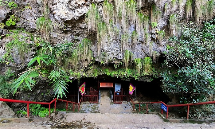
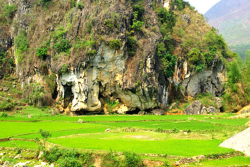
Tien Son cave (other names are Dan Don cave, Po Ngai Tung cave, Da Trang cave, Binh Lu cave) is located next to Highway 4D, in Binh Lu commune, Tam Duong district. Tien Son Cave with caves located in a scenic complex associated with the legend of 99 mountains and 99 lakes of Lai Chau ethnic people - has become a unique beauty that few places have. The legend of Tien Son cave has been passed down through many generations: the 99 mountains are the symbol of 99 healthy, strong boys, while the 99 clear blue lakes are the symbol of 99 hardworking, beautiful girls. Pretty. The mountains and lakes follow each other to create a wall that holds a rich and fertile land. The beautiful scenery and people here became the inspiration for the wonderful lyrics "ninety-nine mountains for boys, ninety-nine blue lakes for girls"... Tien Son Cave has 49 consecutive arcs running through two mountain slopes. The deeper you go inside, the larger the area of the arcs becomes. In the cave there are many stalactites of various shapes and magical colors. At the bottom of the cave, there is a clear stream flowing through, winding through palaces such as: Palace of Merit, Lac Long Quan, Mau Au Co, Ba Chua Kho, clearing injustice, asking for children. Tien Son is a famous natural cave in the region that still retains its wild beauty. During the resistance war against the French colonialists, this place was also a place to hide food and the base of the revolutionary movement. In 1996, the Ministry of Culture and Information recognized Tien Son cave as a national historical and cultural relic and scenic spot. Source: Lai Chau province electronic information portal
Lai Chau 2063 view
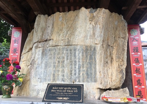
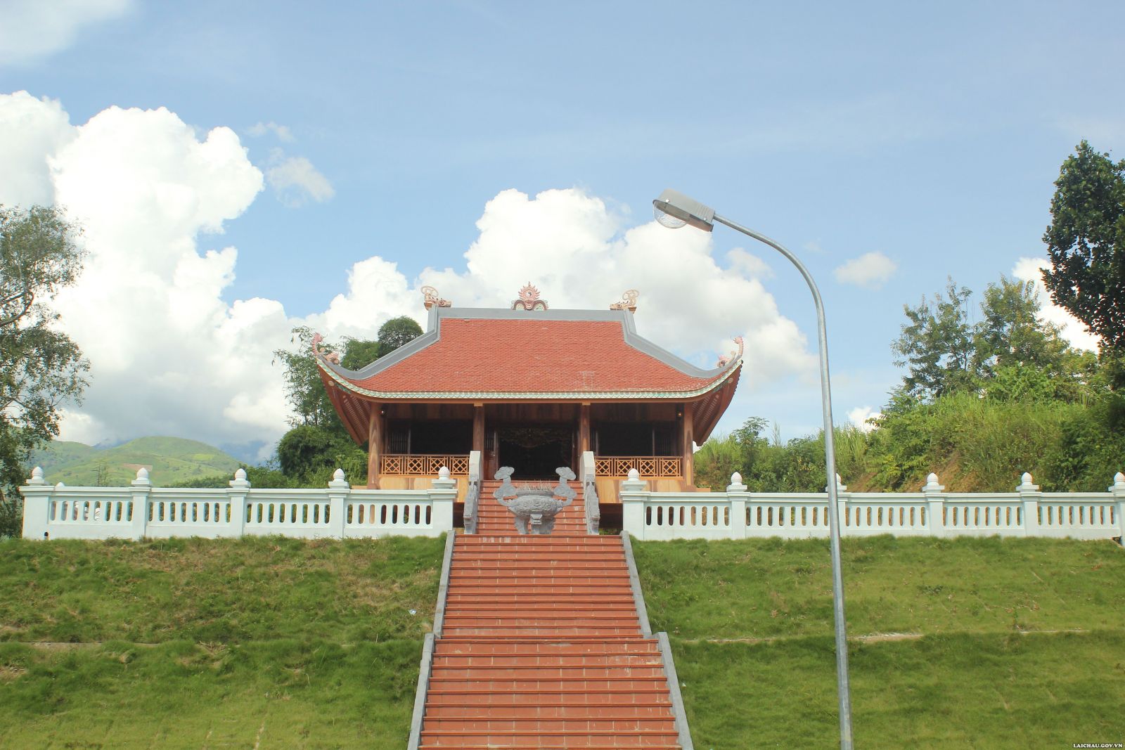
The temple complex of King Le Thai To and King Le Thai To's stele is located 110km southwest of Lai Chau city center, in the administrative territory of Le Loi commune and Pu Dao commune, Nam Nhun district, Lai Chau province. The temple was built to commemorate the merits of national hero Le Loi, who had the merit of quelling the rebellion in the Northwest region. The temple is located on a prime, high location, with views from all four sides. At the King Le temple complex, there is also a precious relic, the Le Loi stele relic. In December of the year Tan Hoi (1431), King Le Thai To had it engraved into the Pu Huoi Cho cliff on the north bank of the Da River to preserve it for future generations. Old history called it "Ancient stele of nostalgia". The stele records the historical event of King Le Thai To personally commanding troops to suppress rebellion in the Northwest region of the country. That was the event in 1431, the chief Deo Cat Han rebelled, allied with Kha Don (also known as Kha Lai) - a rebellious servant of Ai Lao (Laos) to harass the people on the border, and invaded. Muong Muong land (now Thuan Chau - Son La region today). Due to the rebellious actions of Deo Cat Han, King Le Thai To sent King Tu Te and military officer Le Sat to attack. After that, King Le Thai To personally led his army to Phuc Le district (Ninh Vien district). The imperial army advanced along the road from the Red River, then up the Da River, by water and road, defeating the rebels at Cat Han Pass. When the king's army reached Deo Cat Han's lair, Kha Lai and Deo Cat Han fled, then the People captured Kha Lai and killed him. December of the year Tan Hoi - 1431, after pacifying the Northwest region, on the way back through Le Loi commune, Nam Nhun district (currently), to remember this important event and at the same time teach prisoners The leader of the country's borders, King Le Thai To had a poem carved into the cliff. The stele engraved with a poem by King Le Thai To that remains today is an extremely valuable cultural heritage. The stone stele or rather a golden page of history against foreign invaders and greedy chiefs who colluded with foreigners to fight against the feudal state of Vietnam at that time. In 2005, Son La Hydroelectric Plant started construction. To avoid being flooded, the inscription and stele of King Le Thai To were relocated. After being drilled, the autograph was cut into a large block of stone measuring 2.62m long, 1.13m wide, 1.85m high, and weighing over 15 tons. In 2012, Le Loi stele was moved from the Pu Huoi Cho cliff to the temple grounds of King Le Thai To, 500m from the old location. Le Loi Stele Relic was recognized as a national historical site on September 2, 1981. At the end of 2016, Le Loi Beer was officially recognized as a National Treasure. In early 2017, King Le Loi Temple was also ranked as a national historical relic by the Ministry of Culture, Sports and Tourism on January 23, 2017. Source: Lai Chau province electronic information portal
Lai Chau 1945 view
Nang Han Temple is located in Tay An village, Muong So commune and Phai Cat village, Khong Lao commune, Phong Tho district, Lai Chau province. This is a place to worship the legendary character known by the people as Miss Han (She means daughter, Han means hero). Legend has it that Nang Han came from a poor Thai family in Chieng Sa (now Muong So commune, Phong Tho district, Lai Chau province). She disguised herself as a man and stood up to call on the young men of the villages to unite and fight the enemy. She led the uprising of 16 Thai people who stubbornly defeated the Northern invaders. After leading the victorious army back, she bathed in the water of Tay An (Muong So commune) and then flew to the sky. From then on, remembering her gratitude, people built a temple and held a festival right in the water where she bathed. Ms. Han is not only a worshiped figure of people in Muong So commune or Lai Chau province in particular, but Ms. Han is a worshiped figure of all White Thai ethnic people throughout the Northwest region. Miss Han in the spirituality of 16 Thai and Muong regions in the Northwest is like Ba Trung and Ba Trieu to the Kinh people. On December 25, 2007, the People's Committee of Lai Chau province recognized Nang Han Temple as a provincial-level historical, cultural, architectural and artistic relic. Source: Lai Chau province electronic information portal
Lai Chau 1908 view
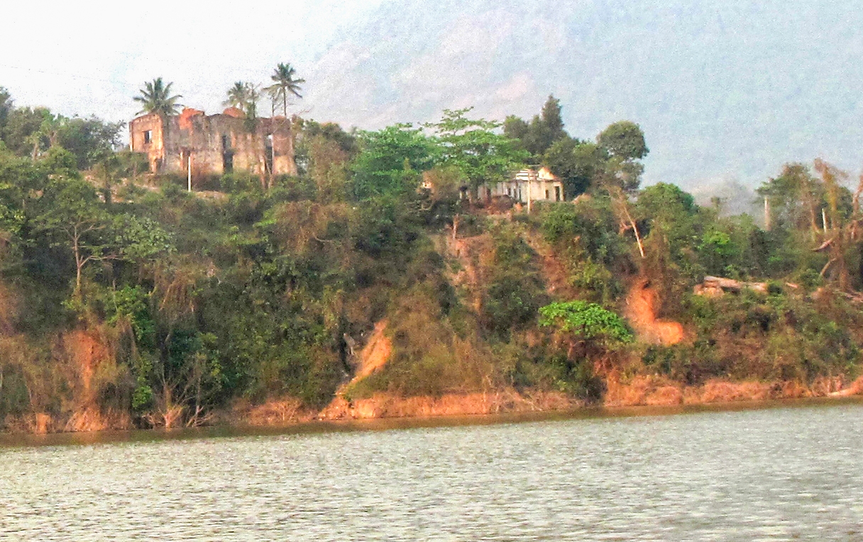
Deo Van Long mansion is located in Le Loi commune, Sin Ho district, Lai Chau province. According to the 1983 survey results of the Department of Culture and Information of Lai Chau province, this project began construction in 1916. The documents left behind about the mansion and the Deo family are still very primitive, but They all believe that all the work of choosing the direction, choosing the location for the main gate, the shrine, and the Dam house (ancestral church) were carefully considered by the Deo family, who hired a geographer. Two architects, one French and one Chinese, were invited to design and supervise, and materials were brought from the lowland provinces. Therefore, the architecture of the mansion has Western features blending Eastern looks, and is also a characteristic of Thai construction art and feng shui. The mansion has an area of about more than 1 hectare. Due to the need for defense, welcoming Indochina Government officials and to satisfy their luxurious lifestyle, the Deo family gathered people, soldiers, and workers for the job. Build a villa complex, located in a critical location, at the junction where the Da River, Nam Na River and Nam Lay Stream meet. Behind the mansion is a high mountain, in front is a confluence of rivers (Da River, Nam Na River and Nam Lay Stream) that can control the road to Phong Tho, Muong Te and down to Hoa Binh, Son La, as well as For example, through Dien Bien to Laos, the terrain is suitable for defending and fighting against the enemy. If they fail, they can retreat safely. In 1918, the mansion was completed with 8 main units: Main gate, Dam house, dining room, swing house, water tower, prisoner cellar, forest ghost shrine and another house with L-shaped face ( unknown purpose). In addition, there are a number of other supporting works such as surrounding walls, side gates, driveways leading to the main gate, long and narrow steps leading down to prisoners' cellars, granaries, boat docks, and cemeteries. The main house is built with two floors of red bricks, wooden floors, and a tiled roof separated from stone slabs, often called black stone (when first separated, the soft stone can be cut with a knife, but when exposed to sunlight, the stone will hard as porcelain). Surrounding the castle is a wall over 3m high, built of 40 to 50cm thick slate, very sturdy, with many battlements on the wall to observe the outside. In front of the main house, there is a large yard for dancing when Deo Van Long holds parties and receives guests. It can be said that the palace complex is an "impregnable fortress" of the Thai king. Speaking of Deo Van Long, he is the second son of Deo Van Tri and a lord of the Thai Autonomous Region in the Indochina Federation. The Deo family comes from an aristocratic lineage in Yunnan (China). They are not reactionaries but have lived together in harmony on the land of Lai Chau for a long time. In the late 19th century, responding to the Can Vuong movement, the Deo family stood side by side with the Black Flag insurgents to defend Son Tay and achieved many victories. However, after huge losses in the decisive battle along with suspicion and lack of internal unity, Deo Van Tri signed a permanent ceasefire treaty with the French army. Protected by the French Government, supported with money and weapons, France restored Deo Van Tri to govern the land of Sipsong Chuthai (12 Thai lands). In 1908, Deo Van Tri died, handing over military power to his son Deo Van Khang. After Khang died, Deo Van Long replaced his brother to take power. From here, with his brutal nature, Deo Van Long spread terror to the people in the area. In addition to sending soldiers to plunder and loot the wealth of the people in the area, the Thai king also built large boats, using the Da River as the main transportation axis to transport forestry and land products that he had robbed from the local people. They went to the lowlands to sell opium, tiger skins, leopard skins, bear bile, etc. then brought the goods up to sell to local people. After the liberation of Lai Chau town (1952), Deo Van Long fled to France in exile, and the mansion was destroyed by the people. Up to now, the entire mansion has become ruins, many buildings have been completely lost and the original architectural shape cannot be determined. In 1980, the Deo Van Long mansion was decided by the People's Committee of Lai Chau province to be classified as a provincial relic and included in the restoration plan. However, since 2010, the Son La hydroelectric project has accumulated water, part of Deo Van Long's mansion has been permanently sunk into the river bed, leaving only a few ruins. Source: Lai Chau Newspaper
Lai Chau 1876 view
“Na Cung Cave” is located in Na Cung village, Muong So commune - Phong Tho district - Lai Chau province. Before dividing the province in 2004, Na Cung Cave belonged to Ban Na Cung - Muong So commune - Tam Duong district - Lai Chau province (formerly). The relic is located on the top of a low mountain, below is the Tung So field with the wings of a stork flying and the Nam So stream in front of the cave entrance which then flows into the Nam Na stream. Standing in front of the cave entrance, you can see the stream flowing as softly as a young girl's white handkerchief fluttering in the wind. Blending into that is the Tung So field with countless plots, promising bountiful harvests and a prosperous and happy life for the people in the area. Our starting point from Lai Chau Town is along Highway 4D with a flat paved road, winding along the curves of the majestic mountainside. On the way, visitors can enjoy the beautiful natural scenery. The wonderful nature of the mountains and forests has a unique character in the Northwest region. With a length of 23km, we will reach the Phong Tho junction, which is 7km long, and there is still a way to go to Muong So town (from this junction to the commune center, about 3km of flat paved road). When we passed the People's Committee of Muong So commune, we arrived at the central market, where the atmosphere was very bustling. People from many places gather to buy, sell and exchange products to serve life. The atmosphere and pace of life here have given us a change in the bustle of society. When passing the reinforced concrete bridge over the Nam Lum river (market bridge also known as Nang Poong bridge). We continue along the main road about 1km to the junction turning into Na Cung village. With the rustic, pristine road of the community, visitors will have a new feeling of separating from the bustling world to return to a peaceful countryside. With stream banks, fields and countless landscapes, anyone feels much smaller. When visitors reach the suspension bridge over Nam So stream, they can access the culture and daily life of the White Thai community here. It can be said that Na Cung village is one of the first villages of the White Thai people in the whole region, this is one of the cradles of culture, revolution and customs. With traditional stilt houses close together, with streams of water flowing throughout the village... All of these things have complemented and enlivened the wonderful natural scenery and diverse cultural life. When completing the dirt road running along the village, visitors will be surprised when before their eyes opens a majestic scene of endless Northwest mountains and forests, with mountains, rivers, streams, and fields combining together to create into a unified whole, a priceless colorful picture of nature. It is here that visitors can reach the historical and cultural relic and scenic spot Na Cung Resistance Cave. Source: Lai Chau province electronic information portal
Lai Chau 1864 view


 vn
vn en
en ja
ja ko
ko zh
zh VIP member benefits