Explore the history, culture, people and beautiful landscapes of Vietnam on the 63Stravel travel app
Download the 63stravel app


Quang Ngai 331 view
Download the 63Stravel app to immerse yourself in countless beautiful photos of Vietnam
Dung Quat Bay or Quyet Bay is located in Binh Thanh and Binh Thuan communes of Binh Son district, north of Quang Ngai province, and borders Nui Thanh district, Quang Nam province and about 18km from the coast.


With two distinct rainy and sunny seasons, the best time to travel to Ly Son is from April to August. During this time the weather is stable, it rains little and is sunny. But you should avoid going during the peak season from April to June, so you don't have to endure crowds. September to December is the season of rain, storms and rough seas. From late December to April is the season of green moss covering the rocky beaches along Ly Son coast. Note, you need to monitor the weather before departing to avoid being stuck on the island for several days due to rough seas, monsoons... The main means of transportation is by boat from Sa Ky port. There are many high-speed boat companies here that take tourists to Ly Son island with ticket prices around 300,000 - 340,000 VND (round trip). Remember to bring your ID card or driver's license to buy tickets. Travel time from port to island is about 35 minutes. From Hanoi and Ho Chi Minh City, tourists book flights to Chu Lai airport with a one-way ticket price of about 1,200,000 VND, flight time 1 hour 30 minutes. The airport is about 42 km from Sa Ky port, you can travel by taxi, one-way price is about 350,000 VND or take a bus that stops in Quang Ngai City to save costs. In addition, visitors have the option to fly to Da Nang, from here take a taxi or train to Quang Ngai City, the train ticket price is 180,000 round-trip. The port is 20 km from the city center. Ly Son has many motels, hotels, and homestays, averaging from 200,000 - 400,000 VND per night. For travelers who prefer a place with a youthful style, they should choose homestay Bep's House, Bé Ecolodge or DHT Hang Cau motel. In addition, visitors can refer to Ly Son Pearl Hotel & Resort with sea view. Visitors can experience staying one night at Be island. Suggested homestays are Ly Son Bungalow with colorful wooden houses, XaLaBin with high rooms with sea view or Sea Breeze. Coming to Ly Son, visitors can rent an electric car for 300,000 VND per trip to explore around the island. In addition, you can rent a motorbike, priced at 150,000 VND per day, to visit places such as: Thoi Loi Peak, Garlic Fields, Cau Cave, To Vo Gate, Hang Pagoda, Duc Pagoda,... and many famous places. another language. Regarding cuisine in Ly Son, restaurants are concentrated along the port, some suggested restaurants are Phat Hai restaurant, Khoi Chieu restaurant... There are also Dai Hang seafood rice restaurant, Ut Ngoc restaurant. Ly Son's specialties are mainly seafood, especially king crab, lobster, conch, ta ma fish, fish cakes... Some other specialties are garlic salad, seaweed salad, crab vermicelli, and melons. black watermelon, giant snail, banh it gai leaf... Visit the dry food stalls on the island to buy garlic and dried seafood as gifts.
Quang Ngai 1718 view
From December to April
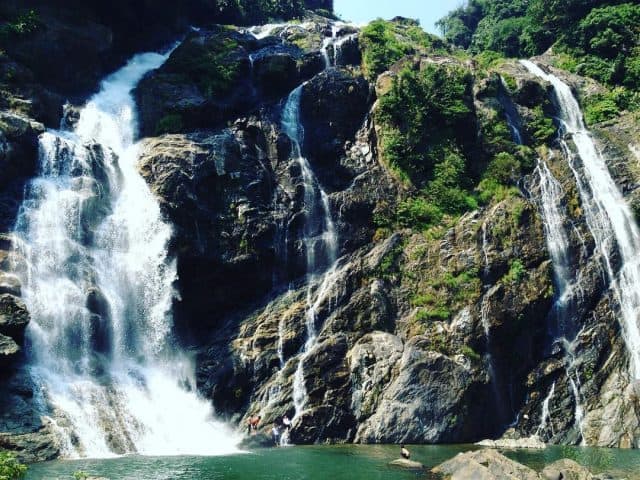
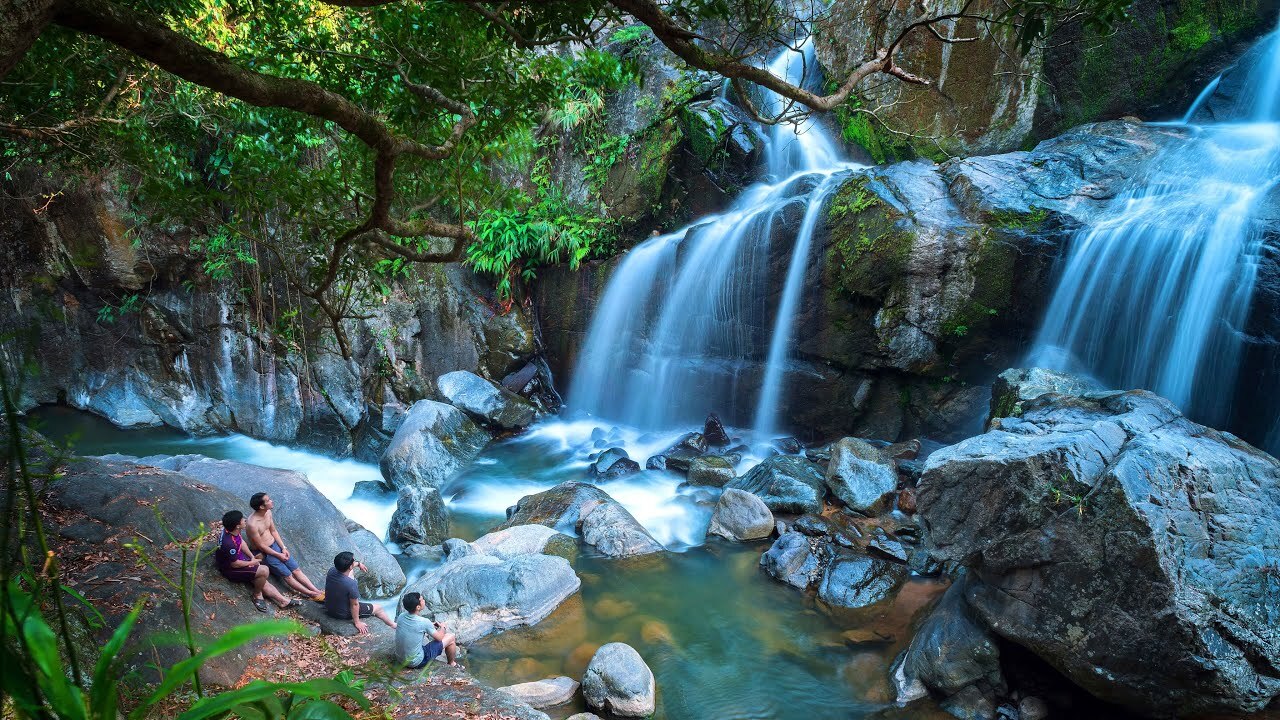
White Waterfall is located in Thach An commune, Minh Long district and about 23 km southwest of Quang Ngai City center. The waterfall is hidden in the historic Truong Son mountain range and has recently been discovered by people. This is an ideal destination for those who want to rest and relax on the weekend and is a favorite place for backpackers today. To go to White Waterfall, from the center of Quang Ngai city, go southwest to Chua market town, Nghia Hanh district. After that, there will be a small pass. If you follow that road, you will reach Minh Long district and continue about 5 km to reach the White Waterfall. The road to the waterfall is now being rebuilt very beautifully, the road is also quite steep so it brings an interesting feeling to backpackers. To get here, an advice for you is to ask local people for directions as you go because following google map will not be accurate. If you don't want to ride a motorbike, you can go by car or catch the bus from Quang Ngai - Minh Long for only 16,000 VND/trip. To Minh Long district, you can catch a motorbike taxi to the waterfall, or rent a motorbike. Motorbikes for only 80,000 VND-120,000 VND/day. White Waterfall is about 40 m high, the water flows day and night into the two lakes below. The waterfall is surrounded by the green of rolling hills and mountains, creating a very poetic and lyrical scene. The waterfall is divided into 3 branches, of which the leftmost branch is the main branch (this is where the water flows the most and most intensely), the remaining 2 sub branches on the right flow less water. At the foot of the waterfall there are 2 large lakes, the water here is very clear and blue, the cool water is very suitable for people to immerse themselves in the refreshing water to dispel the heat of the city. Not only that, this lake is also home to juvenile fish, so you can bring fishing rods and enjoy this delicious, unique dish right on the shore. The water flow is strong and light depending on the season. To admire the strongest water flow, you should come here during the rainy season, when there is a lot of water flowing from above, causing the water flow to be very strong, creating a wonderful scene. Pretty. If you like the peace and simplicity of White Waterfall, you should go in the dry season, when the water flows very gently and smoothly. Coming to White Waterfall, not only can you bathe freely in the cool water and take wonderful photos, but you can also camp, picnic, organize group games, light campfires and lots of other interesting things. The waterfall has been turned into a tourist area so you can have peace of mind about eating, resting, and entertainment. Next to the waterfall there is an empty lot, which is a very suitable place for camping overnight, singing and dancing, and enjoying outdoor BBQ dishes. Around the waterfall, there is also a place suitable for young people who love nature and want to explore: the primeval forest and the villages of the Hre people. If possible, you can also ask permission from the forest management board to camp and play here. Leaving behind the stuffy air of the city and the hot summer afternoons, try coming here once, enjoy the cool air here and you will feel really comfortable and not want to leave. get out of here for a bit.
Quang Ngai 1726 view
From January to December
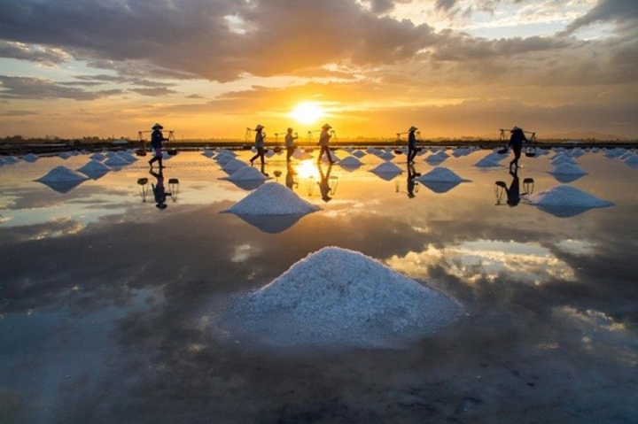
Wearing endless beauty over time, Sa Huynh salt fields are a place for visitors to see the stretching salt fields, the beautiful white colors and feel the essence of the folk craft villages here. Located in Pho Thach commune, Duc Pho district, Quang Ngai, this is not only a salt field with more than 100 years of history, but also symbolizes the connection with the heritage and culture of this land. With more than 600 households and an annual salt output of 8,000 to 9,000 tons, Sa Huynh salt field is not only an important source of salt but also represents the spirit of traditional craft villages, blending with famous craft villages. Others like Hon Khoi and Ca Na are located along the Central region. Since the 19th century, Sa Huynh salt fields have witnessed more than 100 years of preserving tradition. However, salt making in Sa Huynh was not always known as a beautiful landscape. In the past, this place has gone through many ups and downs, from the "bitter salt village" when the effort put in did not achieve results, to the value of salt not being expected and the lack of local brands. But since the day the Intellectual Property Department issued the certificate of "Sa Huynh Salt" in 2011, everything has changed. Salt makers do not hesitate to invest and apply new production models, with Sa Huynh salt making on tarpaulin or cement floors. The results have shown an improvement in quality, with sand impurities reduced by up to 95%, output significantly increased and salt value increased by 20 - 30%. In particular, this new method helps shorten production time and change the landscape of the salt fields. To do this, 6 dikes with a total length of more than 5km were built, paving the way for the development and improvement of the salt fields. This proves the enthusiasm and will for progress of Sa Huynh salt makers, as they constantly learn and share knowledge, building a bright future for Sa Huynh salt grains. With more than 120 hectares of area, Sa Huynh salt fields are like a brilliant carpet, each small field interwoven with each other, understanding the delicate interaction between sunlight and sea water. The concrete and silver foil create a unique reflection of color, turning this beautiful scene into a field that sparkles like diamonds and attracts all eyes. White salt dunes spread evenly across the fields, like embodiments of mountain and forest nature. When the sparkling golden sunlight combines with the farmer's bamboo burden, the painting blends yellow and white to create a captivatingly beautiful scene, blending simplicity and charm, like a mysterious portrait. . When you enter the salt field, this is not only a famous Quang Ngai tourist destination, but also an interesting work of natural art from the hands of farmers. Right from 5 a.m., local farmers gathered to start an enthusiastic working day. They arranged seawater from canals and ditches into the bladder, then sprinkled bait salt and waited for the sunlight to crystallize the salt. Salt making in Sa Huynh requires 3 sun exposure to achieve white and large salt grains. This is an elaborate process, performed under intense sunlight, to create unique and delicious quality salt. In addition to the salt making experience, you also have the opportunity to see unique homemade motorbikes here. These carts, although old, have been converted to carry salt instead of being used for carrying loads. This has improved people's lives and created a sense of fun. If you have the opportunity, please shop and support these pure grains of salt, to see the care and love that people put into each grain of salt.
Quang Ngai 1802 view
March to August
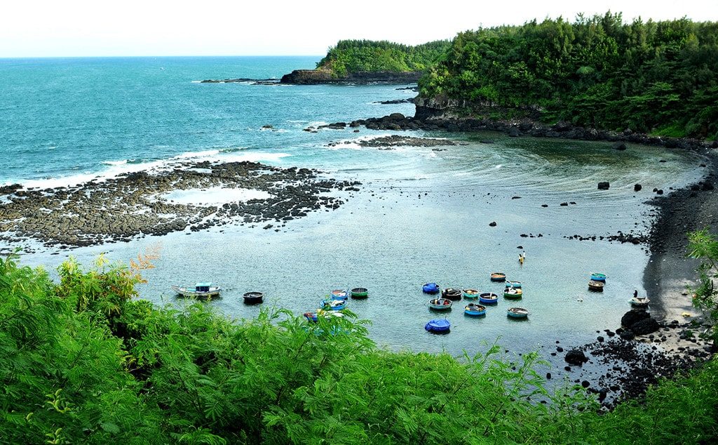
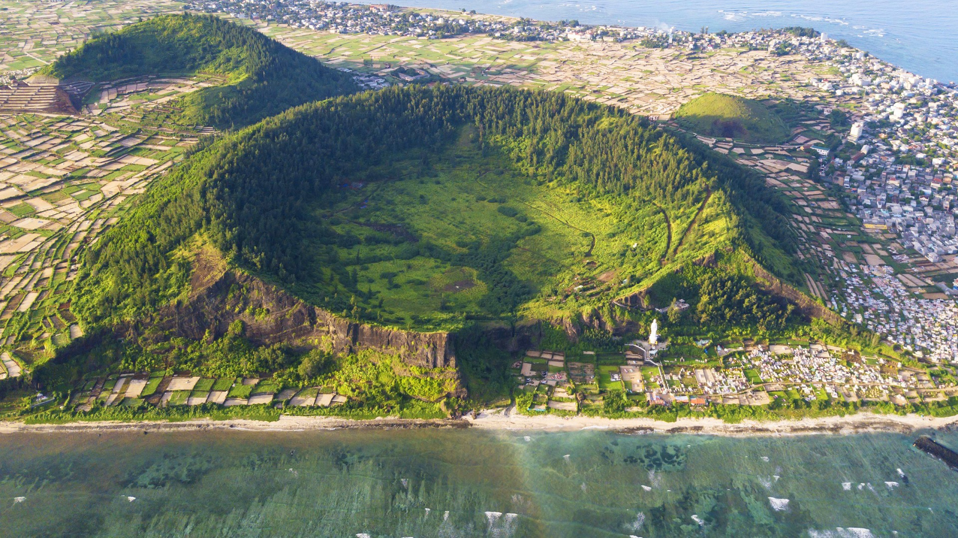
When mentioning Quang Ngai, surely those who love to travel will immediately think of Ly Son island district. However, in Quang Nam, there is another pristine land like "Ly Son Island in the mainland" waiting for tourists to explore. Mui Ba Lang An is located in Binh Chau commune, Binh Son district. The reason for this name is because this is a way to combine the names of three adjacent auspicious places including Van An, An Chuan and An Hai. Here, visitors will enjoy the extremely peaceful life of the Central region's sea and islands. The people of Mui Ba Lang An are also the people who reclaimed Ly Son island, and directly participated in the fight to protect the sovereignty of Hoang Sa island and sea. During the French colonial period, this place was also called Ba Tang tend. This is not only a resort destination but also famous for its rich history, always the pride of Quang Ngai people. Currently, Mui Ba Lang An has been expanded in area and is only about 22km southwest of Cu Lao Re island. This is a cape that helps create the shape of the coastline in our country, and will definitely be an attractive destination for tourists. This cape is made up of volcanic sedimentary cliffs and clear jade blue sea. Looking from above, one can see the extremely magical and seductive beauty. Near Ba Lang An Cape, there is also an inactive volcano crater about 30 square meters wide. Inside the crater, there is a lot of seaweed growing, and the outside is covered with a dense layer of coral with many bright colors. All of these points are blended together, creating a unique wild beauty that can rarely be found anywhere in Quang Ngai. Visiting Ba Lang An cape, visitors will have the opportunity to experience many interesting things such as walking along the beach to admire the scenery and take photos. In addition, you must definitely visit Ba Lang An lighthouse. Just spending about 30 minutes up the lighthouse, visitors will have the opportunity to see the majestic panorama of the cape. After posing and taking many beautiful photos, visitors can continue to admire the beautiful natural landscape. If you are a lover of the sea and enjoy experiences, want to touch your feet and feel the cool ocean water or try touching the undulating rocks below the beach, you can move down to Ba Lang An cape. Surely this will be an impressive experience during your trip to explore Quang Ngai. In particular, when visiting Ba Lang An cape, visitors will have the opportunity to enjoy and breathe the simple life of fishermen on boats and baskets going out to sea. Boats moored on the shore will be an indescribably simple moment that you will not see in the city. However, this place has not really received much investment in tourism development. Therefore, visitors may have to travel further to find the ideal hotel or homestay to stay. Coming here, visitors can go back and forth in the same day because the road is quite convenient and not too far from the center. If you want to stay overnight at the beach, you can ask to sleep at a local family's house. Besides, visitors should prepare comfortable clothes when traveling to Quang Ngai to be able to operate easily. At the same time, sunscreen is indispensable, as well as a jacket, and sunglasses, etc. These are all important accessories because the weather here is quite hot. The most beautiful time that tourists should not miss to come to Ba Lang An cape is from May to August. This is the time when the weather is beautiful and the waves are calm. Because it is not the rainy season, it is very suitable for swimming and admiring the beautiful mountain scenery. However, this is also the peak season for beach tourism in Quang Ngai. Therefore, service prices may increase higher than at other times of the year. You should avoid traveling to Cape Ba from September to February of the following year. This is the rainy season in Quang Ngai, in addition to long rainy days, there are big storms that make strong ocean waves, which will be a factor affecting the quality of your trip.
Quang Ngai 1710 view
From May to August
Vi O Lac Pass - a mysterious destination on Highway 24 connecting Kon Tum (the heart of the Central Highlands) with the coast of Quang Ngai province. This pass starts from Thach Tru intersection, Duc Lan commune, Quang Ngai and ends at Kon Tum city with a total length of about 50km. The pass peak is 1,300m above sea level, not only considered a symbol of the boundary between Quang Ngai and Kon Tum but also the weather dividing point between East Truong Son and West Truong Son. According to history, the original name of the pass is "Vi Ho Lak", but through word of mouth over time, people gradually got used to calling it Vi O Lak pass. Some theories suggest that this name comes from the Violet flower, however, here people only see one type of wild flower on the pass, the torus. It can be said that Vi O Lak Pass with its natural beauty and majestic scenery has become a must-visit tourist destination when you travel to Quang Ngai. Vi O Lac Pass, located in the heart of majestic mountains, is a destination that fascinates people with its wild and unique natural beauty. Although located halfway up the mountain, next to the winding trail are rows of tall, green and ancient trees. This has created a beautiful natural screen, helping the space of this pass become airy and windy. When standing in the middle of the pass at an altitude of 900m above sea level, with just a distant look, you will quickly be fascinated by a vast natural picture: immense green mountains, gentle Re river. Winding among the green carpets and especially in the ripe rice season are golden terraced fields located close to the stilt houses. All of these beautiful landscapes have created a poetic, strangely cute Vi O Lac pass scene. Every step up, every bend you pass, you will definitely feel the change in space and climate. In particular, when reaching the top of the pass in the early morning or evening, a sea of floating, hazy white clouds will appear to cover the entire view, creating a mysterious and magical scene. Standing in front of that beauty, all worries and fatigue disappear, leaving only the soul soaring and light in the vastness of nature. Vi O Lak Pass can be seen as a vivid natural picture, a work of art of creation, where every moment spent here contains magical and memorable things. Vi O Lak Pass with its height and danger is always a challenge for those who want to conquer it. Especially, when one side is a majestic cliff and the other is an abyss with dangerous turns, choosing the right time to explore the pass is extremely important. The 6th lunar month of each year, when the sky begins to clear and the golden rays of sunlight become brighter, is the most ideal time for you to conquer Vi O Lak Pass. At this time, you will experience a clear blue sky, warm sunshine and at the same time admire the floating clouds in the distance. The ripening rice season at Vi O Lak Pass is also an experience not to be missed. Golden terraced fields shining in the sunlight mixed with stilt houses amidst the dim kitchen smoke, create a very beautiful and peaceful natural picture.
Quang Ngai 1751 view
July
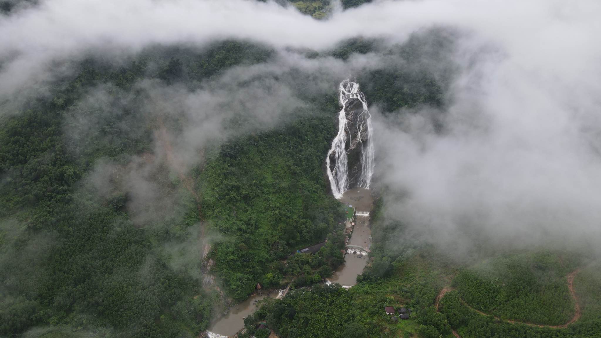
Quang Ngai has long attracted a large number of tourists every year because it not only possesses a fresh, cool atmosphere but also contains extremely unique tourist attractions. Among famous places in Quang Ngai such as Ly Son island, the appearance of Minh Long White Waterfall is also an equally attractive place attracting tourists as well as local people to visit. White Waterfall Minh Long is located about 36km from Quang Ngai city center. If you go from the city center, you will go southwest, starting from Chua market town in Nghia Hanh district to go along the small pass towards Minh Long district. After arriving in Minh Long district, you continue to move straight for another 5km to see a sign pointing to Minh Long White Waterfall. Minh Long White Waterfall is located in Thach An commune, Minh Long district, Quang Ngai province. This place possesses the most outstanding natural scenery, the white waterfall about 40m high flowing from top to bottom parallel to the two sides of the lake below, surrounded by a layer of green of rolling hills and mountains. a poetic, charming natural picture. In addition, at the foot of Minh Long White Waterfall are two large lakes with a clear blue color, suitable for you to take a dip in this water stream to relax and breathe in the fresh air of the green forest. away from the hot weather in the crowded and bustling city. Minh Long White Waterfall is one of the few places that inherits the natural beauty from the land of Quang Ngai with the blend of green trees of the forest and majestic high hills and mountains creating a natural picture. fresh, green and cool. The most prominent highlight of this tourist area is the white waterfall flowing strongly depending on the different seasons along with the clear blue water surface, giving tourists relaxing vacations by soaking in the water and immersing themselves in the beauty of nature. The fresh air of nature, away from all pressures in life. In addition, Minh Long White Waterfall is also a place where you can easily take extremely chill check-in photos at the waterfall because the place is full of colors. The greenness of the forest trees along with the whiteness of the waterfall promises to bring you beautiful, perfect, one-of-a-kind photos. Coming to Minh Long White Waterfall, you can not only admire the beauty of the waterfall along with surrounding scenery but you can also do interesting activities here. Outstanding activities include camping overnight, singing and dancing, and making outdoor BBQs next to the vacant lots at the foot of the waterfall. This helps you to immerse yourself in the natural scenery at the foot of the waterfall, enjoy relaxing moments by the lake as well as find yourself serenity and peace away from the hustle and bustle of life in the city. In addition, another outstanding place at Minh Long White Waterfall that can be visited, suitable for those who are passionate about exploring nature, is the primeval forest and villages of the Hre ethnic group. This place not only allows you to discover more natural beauty, but you also understand more about the unique culture and human beauty of the Hre ethnic group here. Minh Long White Waterfall is one of the few places that possesses poetic and lyrical natural scenery of majestic mountains and forests and rows of green trees, but also contains a fresh, cool atmosphere that will make you relax. You somehow forget the fatigue and worries in the hustle and bustle of life. And besides admiring the natural beauty, you will discover more about the national cultural identity of the local people here to understand more about the beauty of the people of the South Coast region. Central region. If you have the opportunity to visit Quang Ngai, try setting foot at Minh Long White Waterfall to discover firsthand the beauty of this place as well as experience interesting activities next to the waterfall that will surely stay in your mind. your mind with memorable memories.
Quang Ngai 1308 view
From March to August
Quang Ngai tourism attracts tourists by its poetic and majestic landscapes. Among them, Lung O waterfall is a place that many people come to enjoy the fresh, peaceful space after stressful days of work and study. Lung O waterfall is located in Ba Thanh commune, Ba To district, Quang Ngai, about 15km from National Highway 1A and 45km from the city center. As soon as you reach the edge of the forest, you can hear the sound of flowing water, urging you to admire the wonderful beauty of Lung O waterfall. Coming to this Quang Ngai tourist destination, visitors will certainly feel surprised by the wild and majestic natural scenery. The water flows down from above like a soft silk strip across the endless green mountains and forests, creating an extremely eye-catching landscape painting. Here, you will admire the image of a waterfall flowing with white foam, and at the same time relax in the fresh space. At the foot of Lung O waterfall is a lake about 200m2 wide with emerald green water. At the foot of Lung O waterfall in Quang Ngai, there is a lake about 200m² wide with beautiful jade green color. The lake is surrounded by large rocks, creating an ideal space for visitors to relax and refresh their spirits after stressful working days. You can enjoy the feeling of soaking in the cool water of the lake, while listening to the singing of the mountains and forests. Surely, this experience will make you want to come back here again and again. In addition to admiring the scenery and bathing in the stream, visitors can also participate in a number of interesting activities at Lung O waterfall such as camping on large rocks on the banks of the stream, rolling up their pants and wading in the stream to catch fish, or even Stand on a high rock to jump into the lake or climb a mountain to reach the waterfall. Don't forget to take check-in photos with the majestic waterfall to capture memorable memories. Surrounding the lake are large rocks. This is the ideal place for visitors to shake off all worries and "reset" themselves after a series of stressful and tiring working days. Not only that, you can also immerse yourself in the cool water of the lake. The feeling of soaking in the clear water while listening to the joyful song of the mountains and forests will definitely make you come back here again and again. After having fun at Lung O waterfall, visitors should not forget to enjoy Quang Ngai specialties such as grilled beef with lolot leaves, grilled fish with onion fat... In particular, grilled tilapia fish with onion fat and dipped in the signature dipping sauce is a delicious dish for you. definitely must try. To fully enjoy the chill feeling, visitors should order a few dishes and buy some drinks and go to the rocky shore next to the waterfall to enjoy. Revealing that the cool water is a magical "refrigerator" for you to soak fruits and drinks. However, the path to the waterfall is quite narrow, so you should ride a motorbike to easily move and save time. If you intend to organize a picnic by the stream, prepare food, water and a mat in advance to enjoy a comfortable and convenient picnic. When visiting, wear comfortable clothing and sneakers with good traction. This will help you move easily on difficult terrain and avoid the risk of slipping. Don't forget to prepare insect repellent and wound dressings. They will help you prevent insect-related problems and treat minor injuries if any. When cooking, find a well-ventilated place with no leaves nearby to avoid the risk of causing a forest fire. Ensure safety for everyone around and protect the environment around the waterfall. With its wild and majestic beauty, Lung O Waterfall in Quang Ngai has attracted many tourists to visit and explore. This is one of the great destinations to get away from the stresses of modern life and enjoy peaceful moments in nature. Let's come to Lung O Waterfall in Quang Ngai and discover its beauty.
Quang Ngai 1407 view
From March to August
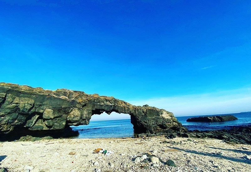
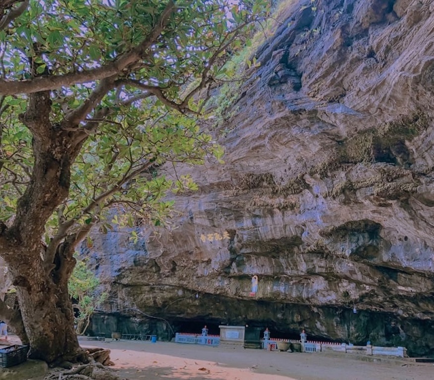
The To Vo stone gate landscape located in the west of Lon Island, Ly Son island district (Quang Ngai) is known as a masterpiece of chemistry, with the harmonious beauty of stone, sea and sky. It's called a "gate" but it's actually a natural stone bridge, nearly 8m long, the height depends on the tide level, but is usually about 5-6m (compared to the bridge above), 2.5m -3.5m (compared to the bridge below) at low tide. From field observations and based on stratigraphic comparisons, geologists said that more than 1 million years ago (in the Pleistocene), Gieng Tien volcano had a very strong eruption, called explosive eruption. The lava flow escaping from the volcano covered older sediments (in the late Mio cene), about 5.5 - 6 million years ago. This volcanic eruption is the main cause of the formation of spectacular landscapes around the Gieng Tien mountain area and the west of Big Island. In the sea area of To Vo gate, the lava flow flows into the moving sea water, is condensed by the water flow, followed by the process of landslides and erosion of weak structural parts of the lava block, forming a type of rock. To Vo Stone Gate Bridge is a natural stone as we see today. To Vo Arch is beautiful and famous for its unique shape, standing tall in the middle of an airy natural landscape. Each block of stone is solid and angular, but when connected together, it forms a stone gate with a soft, flexible shaping rhythm and can display beauty in all angles of space, as well as at any time. any day, even on moonlit nights or when the sky is filled with starlight. Early in the morning, the sun slowly appeared, the first sunlight of the day was like the hand of the goddess Rang Dong spreading high into the sky to play with the wings of seagulls gliding in the air. At noon, soccer ball cages water balloons; waves wavering; suddenly disappear, suddenly appear; like yes, like no. When sunset falls, from the rocky beach, looking through the arch of the gate, there are glimpses of fishermen's fishing boats slowly returning to the wharf to rest for the night in the whisper of the waves and wind in the distance. But the interesting thing is when climbing to the roof of the stone gate to heaven. Looking to the East is a fishing village like a painting of undulating water waves. Slightly to the north is Gieng Tien cliff with Duc pagoda. In the distance is Be Island, with looming coconut shadows, a Dun island emerges as if to remind that there is Bo Bai Island, Be An Binh Island, as beautiful as a poem. Further away, pointing directly to the west, is the mainland, the ancestral homeland of the island clans, with Tong Binh cape reminiscent of the heart-wrenching folk song: The clear sky saw the General Binh Ask if your old friend remembers you or not? In the midst of heaven and earth, suddenly I want to press my small human feet down on a block of lava that has been extinguished since ancient times, then raise my eyes to look up into the abyss and recognize the flashes of light from far away in the universe. Is it possible that the stone dome that is wrapping its arms around the sea can hold its natural essence with us in the midst of a beginningless, endless stream of time? Eastern people believe that every existence in this world has a symmetrical existence. There is day and there is night. There is an Evening star so there is a Morning star (later science showed that the Evening star and the Morning star are just one, which is Venus). There is light playing on the top of the mountain and there is also twilight darkness under the bridge. But with To Vo stone gate, that symmetrical existence is surprising. On this side, Lon Island, there is To Vo gate rising high, basking in the moon and moon, on the other side, on Be An Binh island, there is also a To Vo gate soaking in the water bottom. Also from volcanic eruptions, also solidified lava. Coming to Ly Son, take the time to admire the magical landscape of To Vo gate, a natural stone bridge between heaven and earth on the Big Island. Wait until the spring equinox, when the sea water becomes warm, take a scuba diving trip to see the colorful coral reefs, to see To Vo gate shimmering in the sea water on Bo Bai island (another name for the island). Baby) will be extremely interesting. Visiting To Vo stone gate is an experience not to be missed when coming to Ly Son. This is not only an attractive tourist destination because of its natural beauty, but also gives visitors the opportunity to learn about geological structures, tectonic history along with magical mysteries hidden for millions of years in each region. stone veins.
Quang Ngai 1515 view
From March to August
Thien An Mountain has long become a symbol associated with nature and people of Quang Ngai province. This is a tourist destination that should not be missed when arriving in Quang land. Thien An Mountain is also known by another name: Kim An Son or Thien An Niem Ha. This is a mountain located on the left bank of Tra Khuc River, in Tinh An commune, Son Tinh district, about 3.5km from Quang Ngai city. This mountain has a fairly wide and flat top, the four sides are trapezoidal shaped and dense with grass. With a height of up to 100m, Thien An Mountain is like a giant seal lying majestically on the banks of the largest river in Quang Ngai province. Tourists who want to visit Thien An Mountain can start their journey from the intersection of Tra Khuc bridge on National Highway 1A. When you meet Highway 24B, turn east and continue moving for about 5 - 10 minutes to reach the foot of the mountain. The road to Thien An peak is quite easy to go because the slope of the mountain is not high, the road is wide and completely paved. Therefore, most vehicles can get on and off easily. The history of Thien An Mountain is a legend associated with a Zen master named Le Duyet, dharma name Minh Hai, pseudonym Phat Bao, monk Phap Hoa, born in the year Giap Than (1644) of the Lam Te Zen lineage. This Zen master went to Thien An mountain, built a hut and practiced meditation. According to legend, he only ate leaves, wild tubers and drank water from the cave to live. But then the water in the cave ran out, so the Venerable decided to dig a well. With the additional help of a young monk, the monk and his disciples dug a well for three months but with no results. After meditating for 7 days and 7 nights without eating or sleeping, the monk's heart was touched by the Bodhisattva. The Bodhisattva appeared and told him where to look for water. When he found the water source, the young monk also disappeared soon after. To show respect, people named this well Buddha's well because the water from the well never dries up. On the eastern side of Thien An mountain is a pagoda of the same name hidden behind rows of large ancient trees. Thien An Pagoda located right on earth is considered extremely sacred in the minds of Quang Ngai people. This ancient pagoda was built at the end of the 17th century and was given the title "Sac Tu Thien An Pagoda" by Lord Nguyen in 1717. Initially, this place was just a small pagoda, but became more and more attractive. Many monks, nuns and Buddhists choose it as a place to stop. Later, this place became a famous temple on Thien An mountain visited by tourists from all over. In the temple grounds is an ancient well with no bottom. Legend has it that to dig this well, a Zen master had to meditate for 7 days and 7 nights to pray to the Bodhisattva and had to work hard for many months to dig to find the water source. Therefore, this well was named Buddha Well by the people. The surprising thing is that after such a long time, Buddha's Well has never run out of water. In addition, Thien An Pagoda also has a large bell called Chuong Than, brought back from Chu Tuong bronze casting village in 1845 during the reign of King Thieu Tri. In addition, on the east side of the pagoda there is a hexagonal grave area. sense. This is the burial place of the ancestors and abbots of the temple over many generations. The tomb area includes towers built in 5, 7 or 9 floors. Outside are lotus-shaped statues and tombstones recording the merits of the deceased. In particular, at Thien An peak, on the open, flat land to the west, there is also the grave of Mr. Huynh Thuc Khang. This is one of the places not to be missed on your upcoming trip to Quang Ngai. Since ancient times, Thien An Mountain has been considered the "first landscape" of Quang Ngai province. Standing from the top of the mountain, visitors will have the opportunity to admire the panoramic view of the mountains, interspersed with fertile fields and colorful villages, forming a charming landscape picture of Quang Ngai province. . The image of Thien An Mountain and the spiritual pagoda on the top of the mountain demonstrate the strong spiritual attachment to the people here. The two images of Buddha Well and Magic Bell have both entered poetry, associated with unforgettable anecdotes of the people of Quang Ngai. Every year, at Thien An Mountain, the local government organizes many special festivals such as Mr. Huynh's memorial service or religious festivals undertaken by pagodas and believers. This is an occasion when Quang Ngai attracts a large number of tourists to visit, visit the scenery and enjoy the peaceful atmosphere at this famous mountain.
Quang Ngai 659 view
From March to August
Ca Dam Mountain is an ideal destination for many tourists when coming to Quang Ngai, especially for those who like to explore. Coming here, you can not only enjoy the beautiful scenery but also immerse yourself in the fresh, clean air. When you have the opportunity to travel to Quang Ngai, you should not miss the opportunity to admire the beautiful scenery in the mountains. Ca Dam. This place not only has rolling mountains and mild weather but also many interesting experiences waiting for you to explore. Ca Dam Mountain, also known as Ca Dam, K'Dam or Van Phong Tuc Vu, is one of 12 Notable Quang Ngai tourist attractions. Which district does Ca Dam Mountain belong to? The mountain's location is in the middle of the boundary of three districts: Tra Bong, Son Tay and Son Ha. The distance from Quang Ngai city center to Ca Dam mountain is about 70km to the Northwest. With an altitude of 1,413m above sea level, this mountain is considered the "roof" of Quang Ngai. The scenery here is also considered as poetic as the famous Ba Na Mountain in Da Nang. Although it still retains its wild look and has not received much investment, Ca Dam promises to become an attractive eco-tourism destination, attracting tourists in the future. Conquering the peak of Ca Dam mountain is one A wonderful experience that visitors should not miss. Possessing an altitude of up to 1,413m, Ca Dam Mountain is the highest mountain in Quang Ngai. When standing on the top of the mountain, you will admire the vast scenery right in front of you, feel the cool breeze and feel like you can touch the clouds flying by. However, the road to the top of the mountain is still quite bumpy, and during the rainy season it will be quite slippery, so be careful when moving. A special feature at Ca Dam Mountain is the three-tiered waterfall, an extremely unique waterfall located at the top of the mountain that you must definitely visit. The waterfall's water flows rushingly all year round, creating white waves that float and wrap around like soft silk strips, gently crossing the mountain slope. With a special height, the three-tiered waterfall's water is always clear and when the sunlight shines on it, the water shines and sparkles like a very magical diamond. After overcoming the winding mountain road, visitors can enjoy the cool water of the waterfall, listen to the soothing sounds of birds mixed with the sound of falling leaves, bringing a feeling of relaxation and peace. The name "Van Phong Tuc Vu" conveys all the beauty that nature bestows on this mountain. When you come here at dawn, you will fully feel the scenery of the green pearl hidden in the white, floating clouds. At the moment the sun rises, you will admire the sight of a giant "fireball" slowly lifting the curtain of clouds and radiating gentle, warm rays of sunlight onto the landscape, making the whole mountain seem to awaken. sparkling with magical, magical light. Don't miss the experience of hunting clouds on Ca Dam peak. Once you arrive at Ca Dam mountain, don't forget to visit Que village - the only village of the Kor ethnic group living on the top of the mountain. The people here are very honest, generous and always enthusiastic to guide tourists. You will experience sleeping in a stilt house, waking up to the sound of wild chickens crowing and the smell of fragrant smoke from the small kitchen. This feeling will bring you a freshness and vitality, completely different from the sound of your phone alarm. And of course, cuisine is also an attraction that visitors cannot ignore. Nien fish, hill chicken, dot leaf cake, wild banana soup, wild vegetables, stone snails... are unique specialties at Ca Dam mountain that are loved by many visitors from far and wide. Besides other famous landscapes in Quang Ngai, Ca Dam Mountain is also an ideal tourist destination that tourists should not miss.
Quang Ngai 524 view
From March to August
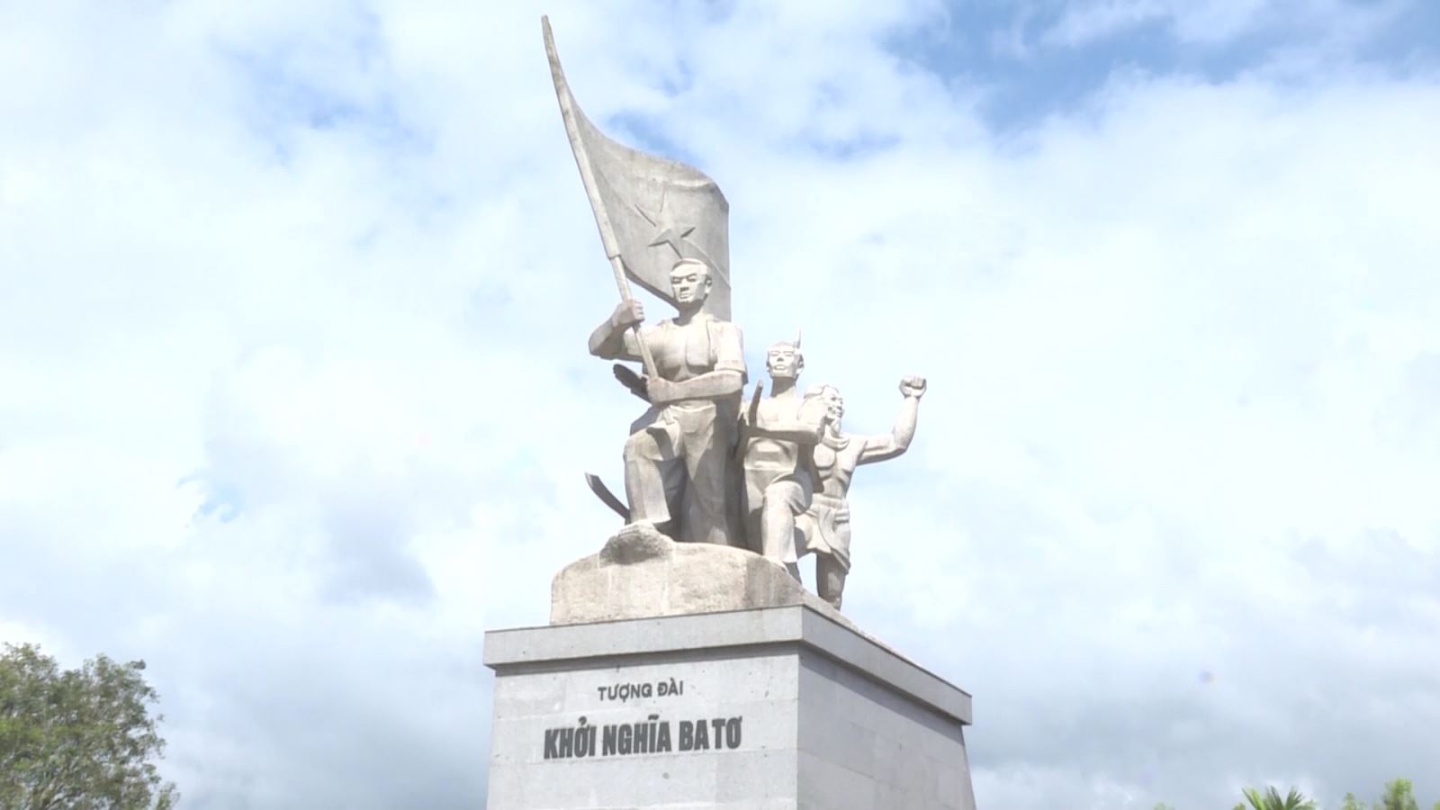
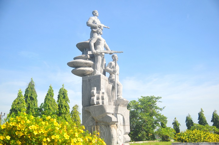
The Ba To uprising broke out on March 11, 1945 with 278 guerrilla members, two days after Japan overthrew the French in Vietnam, establishing a new government in Ba To district and Quang Ngai province. The Ba To uprising was associated with the Ba To Guerrilla Team, the first armed organization of the people of Quang Ngai province directly organized, trained and led by the Communist Party of Vietnam. The Ba To guerrilla team is one of the revolutionary armed forces born in the pre-uprising period and became the core force of the revolutionary masses in Quang Ngai during the days of the general uprising in August 1945, contributing part in building revolutionary armed forces in Thua Thien - Hue and the South Central region. Many members of the Ba To Guerrilla Team later became talented officers and excellent generals of our army in the two resistance wars against the French and the Americans. In 1980, the complex of relic sites about the Ba To uprising and the Ba To guerrilla group was recognized as a national historical and cultural relic by the Ministry of Culture and Information. In 2010, the Ba To Guerrilla Team was awarded the title of Hero of the People's Armed Forces during the anti-French period by the State. Accordingly, the special national relic site of the Ba To uprising includes 11 locations:. 1. Lieng river section (Ba To town), behind Ba To station, where revolutionary soldiers pretended to have tuberculosis, demanded to live in isolation under boats, covered the enemy's eyes to print leaflets and propaganda materials Revolution. 2. Nuoc Nang brick kiln (Ba To town), where the Quang Ngai Provincial Party Committee was established at the end of December 1944. 3. Comrade Tran Quy Hai's house (Ba To town), where the Provisional Provincial Party Committee held an extraordinary meeting (March 10, 1945) to decide to rebel and seize power. 4. Suoi Loa watchtower (Ba Dong commune), where the Quang Ngai Provincial Party Committee held an emergency meeting at noon on March 11, 1945 to decide on the direction of the uprising to seize power in Ba To district capital. 5. Ba To station, the garrison of the army commanded by the French station chief, controlling Ba To district, was captured by insurgents on the night of March 11, 1945. 6. The Procuracy Department (Ba To town) is where on the night of March 11, 1945, rebel forces rounded up Procurator Bui Danh Ngu, confiscating all seals, records, documents, and weapons; take power back to the people. 7. Ba To Stadium (Ba To town), where the Ba To guerrilla team was founded and where on the morning of March 12, 1945, the Uprising's Steering Committee organized a large rally, declaring He abolished the feudal colonial government and established a revolutionary government. 8. Hang En beach (Ba Vinh commune), at the foot of Cao Muon mountain, is where on the night of March 14, 1945, the Ba To guerrilla team held the oath "Sacrifice for the Fatherland!". 9. Ben Buon (Ba Thanh commune), this is the place to receive food and weapons donated by lowland people, transported by river to supply Ba To guerrillas to build an anti-Japanese war zone in Fig Juice, Leaf Juice. 10. Nuoc La War Zone - Voot Rep Cave (Ba Vinh commune), where the Ba To guerrilla group stationed troops, built a base, and practiced military resistance against the Japanese. 11. Cao Muon Mountain War Zone (Ba Vinh commune), one of the places where the Ba To guerrilla team based itself in the early days of the uprising, building forces and cultivating Kinh-Thuong solidarity. In August 2013, the Prime Minister decided to recognize the communes: Ba Vinh, Ba Giang, Ba Dong, Ba Chua, Ba Thanh and Ba To town as belonging to the "Central Safety Zone in Quang Ngai" during the anti-French period. On December 25, 2017, the Prime Minister decided to recognize the locations of the Ba To uprising as "Special National Monuments". Source: Collection of national monuments
Quang Ngai 2344 view
Memorial area of Prime Minister Pham Van Dong in Duc Tan commune, Mo Duc district, Quang Ngai. Where many high-ranking delegations from the Party and state, from Quang Ngai province and the people of the country, international friends come to commemorate and learn about Prime Minister Pham Van Dong. Prime Minister Pham Van Dong was born in Thi Pho Nhat village. Since 1925, he participated in the student movement fighting for the French to release Phan Boi Chau, and mourned Phan Chau Trinh. In 1926, he participated in a training course organized by Nguyen Ai Quoc and was admitted to the Vietnam Revolutionary Youth Association. From then on, young man Pham Van Dong embarked on the revolutionary path. The August Revolution was successful and he held the position of Minister of Finance. During the years of resistance against the French, he was a representative of the Party Central Committee and the Government in the South Central region. In 1949, he was appointed Deputy Prime Minister and from September 1954 also served as Foreign Minister and Head of the Central Foreign Affairs Commission. Then from September 1955 to December 1986, he held the position of Prime Minister. Tourists often stop for a long time at the artifacts of the late Prime Minister's daily life. A bike. One suitcase. Coffee box containing rice. Mr. Nguyen Tan Van, Former Vice Chairman of the People's Council of Mo Duc district, Quang Ngai province shared his thoughts: I visited the souvenir area many times, stopped for a long time at the bicycle and the rice cart with 4 food boxes when going. work and was touched by Uncle Ho's simplicity. Prime Minister Pham Van Dong always mingles with the people, sticks with the people, shoulders the burden, and leads the Vietnamese revolution through extremely difficult historical periods. In every position and responsibility, the Prime Minister has completed his duties excellently. During the years of resistance against the French, as a representative of the Party Central Committee and the Government, Pham Van Dong, along with martyrs Huynh Thuc Khang and Nguyen Duy Trinh, directed the fight against the French to maintain the freedom zone of Inter-Region 5. Especially , an extremely astute person in foreign affairs, was the head of the delegation of the Government of the Democratic Republic of Vietnam to the Fontainebleau Conference in France in 1946, and the head of the delegation to the Geneva conference in 1954. Although, busy Busy with national and people's affairs, Prime Minister Pham Van Dong always cares about the young generation and the country's education cause. Educate and cherish the future generations of the country and the nation. During 75 years of revolutionary activities, 41 years as a member of the Party Central Committee, 35 years as a member of the Politburo, 32 years as Prime Minister, 10 years as Advisor to the Party Central Committee, Prime Minister Pham Van Dong has made many great contributions. Prime Minister Pham Van Dong's life is a life of commitment to the revolutionary cause of the Party and the nation. The 115th birthday anniversary of Prime Minister Pham Van Dong is another time to remember and pay tribute to the contributions of the Prime Minister who always lives in the hearts of the people. Source: Quang Ngai province website
Quang Ngai 2185 view
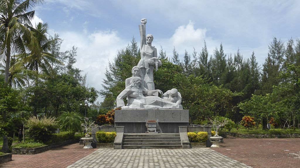
Son My relic site, located next to Highway 24B, belongs to Tu Cung village, Tinh Khe commune, Son Tinh district, Quang Ngai province. This is a place to preserve evidence of the scene, as well as a place to display images, artifacts and place a monument commemorating the 504 victims of the Son My massacre, also known as the My Lai massacre. Son My is the name the Saigon government gave to Tinh Khe commune, while My Lai is the spelling in military documents and maps, and later in the American press, to designate Tinh Khe commune. This name originates from the name of My Lai village, one of the four villages (hamlets) of Son My. Pinkville (Pink Village) is also another name for Son My used by the US military as a nickname in combat maps. The Son My massacre occurred on March 16, 1968, on February 18, Mau Than year, according to the lunar calendar. The main unit that caused the bloody event that shocked world public opinion was the 1st platoon, 11th brigade, Army division, American expeditionary force. On that "terrible morning", after heavy rounds of artillery shelling the village, American troops landed by helicopter on the fields west of Tu Cung hamlet and Go hamlet (Co Luy hamlet) in Tinh Khe commune. The insanely brutal and destructive massacre began with American soldiers hunting down and shooting civilians. Houses and shelters were destroyed, burned, and cattle were shot and killed. The climax of the brutality was the gathering of villagers, mostly old people, women and children, into groups and then shooting and killing. 102 people were killed at Watchtower, 170 others were shot in a ditch east of Thuan Yen hamlet, Tu Cung hamlet. American soldiers did not encounter any reaction from the "enemy" side, other than the screams of panic and pain from innocent victims. Their only loss in personnel was when black soldier Herbert Carter shot himself in the leg to avoid participating in the massacre of his fellow men. Horrifying truth:. In just one morning, 504 innocent civilians were killed (407 people in Tu Cung village, 97 people in My Hoi village), including 182 women, 173 children, and 60 elderly people. There were 24 families killed, 247 houses burned down. Immediately after the massacre, the National Liberation Front Committee at all levels and the Government of the Democratic Republic of Vietnam spoke out to denounce the crimes of the American expeditionary force before domestic and foreign public opinion. However, it was not until a year and a half later that this horrifying event was revealed in America by American journalists and veterans. Americans and the whole world were shocked. The movement opposing America's involvement in Vietnam spread widely. Many prestigious figures, intellectuals, and social activists in the US and many parts of the world demand that leading figures in the White House and the Pentagon be put on trial for war crimes. After the liberation of the South, the revolutionary government protected the remaining evidence after the massacre, built a memorial for the victims and a house displaying pictures and artifacts related to the Son My massacre. In Thuan Yen hamlet, Tu Cung hamlet, next to the water canal that was once red with the blood of 107 victims who were collectively murdered. After many restorations, the evidence area now has an area of 2.4 hectares, including two main areas: the field evidence area (west) that has been preserved and restored and the additional exhibition area and statues. memorial, reception house (east). In addition, there are relics related to the massacre in Tu Cung village and My Lai village. There are documentary films recording the stories and images of survivors, and many scrapbooks that visitors have written in in many languages, truly expressing the feelings and attitudes of many people. people, of many generations, many different religions, ethnicities and political trends, when learning firsthand about the Son My massacre. Source: Quang Ngai Electronic Newspaper
Quang Ngai 2177 view
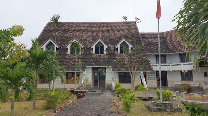
Martyr - Doctor Dang Thuy Tram was born on November 26, 1942, a son of his hometown Thua Thien Hue, born and raised in Hanoi. Father is surgeon Dang Ngoc Khue, mother is Pharmacist Doan Ngoc Tram - former lecturer at University of Pharmacy, Hanoi. In 1966, after graduating from Hanoi Medical University. Dang Thuy Tram brought with him the strength of youth, the will to fight, and the ambitions of youth, volunteering to accept the duty of a physician in the Southern battlefield. Her working place is Duc Pho district hospital, Quang Ngai province. While on duty in the area, she was ambushed by the enemy and heroically died in 1970 at a very young age, just under 28 years old with 3 years of professional experience and 2 years of Party life. Local people buried her right on the land where she sacrificed and her family reburied her at the Martyrs cemetery in Xuan Phuong commune, Tu Liem district, Hanoi capital. Dang Thuy Tram relic area includes: Dang Thuy Tram Clinic in Pho Cuong commune, Duc Pho district and historical relics associated with Dr. Dang Thuy Tram's activities during the war such as: Forward surgical station in Bong Dau mountain, Quy Thien village, Pho Khanh commune. Secret bunker in the garden of physician Ta Thi Ninh in Nga Man village, Pho Cuong commune. Duc Pho clinic at Go Chay hill, Dong Ram 1 village, Ba Kham commune. Duc Pho Clinic in Nuoc Dang village, Ba Trang commune, Ba To district. Dang Thuy Tram Clinic is located right next to National Highway 1A, about 50km south of Quang Ngai city. The clinic was built according to the wishes of Dr. Dang Thuy Tram during his lifetime. This is the first medical examination and treatment model with a special model in the nationwide community health care and examination system. In addition to performing medical examination and treatment for people in the area, the clinic is also an address that attracts tens of thousands of visitors each year. Dang Thuy Tram Clinic was built on an area of 3,900m², with architecture following the style of Rong house - Central Highlands so that visitors can feel the closeness and friendliness. Palm rows along the walkway and front porch make the clinic look like a resort with a garden. Prominent on the main campus is the monument of Hero and Martyr - Doctor Dang Thuy Tram, holding a hat to cover his head, striding forward, as if rushing through the forest while on duty, looking for a new location. It was safer to build an infirmary to treat wounded soldiers and avoid enemy raids. In addition to the treatment area, the clinic also has a separate display area introducing artifacts and images related to Heroes and Martyrs - Doctor Dang Thuy Tram in particular and the revolutionary struggle tradition of the Duc Pho people. (Quang Ngai) and Zone 5 in general. In particular, in the exhibition hall are the luggage left behind by Doctor Dang Thuy Tram before his death, which are two diaries that were picked up on the battlefield by an American veteran named Frederic Whitehurst, a former US military intelligence officer. and kept for 35 years until it was returned to the author's family at the end of April 2005. Due to difficulties in finding Doctor Dang Thuy Tram's family and seemingly despair, 2 diaries This document was donated by Frederic Whitehurst to the Vietnam Archives Institute at the University of Texas, Lubbock for storage and preservation. These two diaries were later published by the Writers' Association Publishing House as a book titled "Dang Thuy Tram's Diary". The works were successively translated into many languages and published in many countries, making the image of Dr. Dang Thuy Tram familiar to international friends, becoming a shining symbol of the spirit of fighting against injustice. hidden and the desire for peace of the young generation of Vietnam. It can be said that with the far-reaching influence of Dang Thuy Tram's diary, it is one of the bright examples for spiritual education and revolutionary heroism in modern times... That is why today the Dang Thuy Relic Area Tram is a very famous attraction for young people every time they have the opportunity to visit Quang Ngai. Source: National Museum of History
Quang Ngai 2096 view
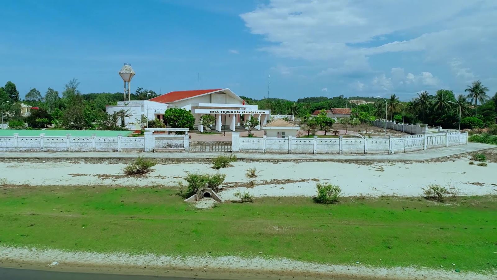
Sa Huynh culture is an archaeological culture of the Metal Age, formed at the peak of civilization in the Iron Age dating from 500 BC, ending in the second century AD, originating from formed and developed from the previous pre-Sa Huynh cultures of the Early Bronze and Middle Bronze Ages. The distribution of Sa Huynh Culture is in Central Vietnam, the North intersects with Dong Son Culture in Quang Binh, the South intersects with Dong Nai Culture in Binh Thuan, the West is the edge of the Central Highlands, the valley area. East of Truong Son, the east reaches out to the island near the shore. The basic burial formula of the Sa Huynh Culture is tombs with jars buried in large cemeteries. At the same time, jar tombs and earthen tombs are also found at burial sites of the Sa Huynh Culture. Typical jewelry of the Sa Huynh Culture are two-headed animal earrings, three-pronged earrings, agate beads, bracelets made from gems, glass, and sea mollusk shells. Glass making and iron smithing are outstanding achievements of Sa Huynh civilization, playing an important role in promoting the development of Sa Huynh society. Sa Huynh culture has extensive exchanges with other cultures in mainland and island Southeast Asia. Sa Huynh cultural special national relic is a type of archaeological relic, with 6 relic sites including:. An Khe Lagoon, An Khe Creek - Cua Lo River, Phu Khuong, Long Thanh, Thanh Duc, Champa Relics Complex. The two locations Long Thanh and Phu Khuong have been decided by the Ministry of Culture and Information to be ranked as National Historical and Cultural Monuments. 1. Location of Long Thanh relic. Long Thanh relic site (also known as Go Ma Vuong) belongs to Long Thanh 2 residential group, Pho Thanh ward, Duc Pho town. Long Thanh is a pre-Sa Huynh relic of the early Bronze Age, the direct origin of the development of the Sa Huynh Culture of the early Iron Age. Long Thanh relic stands out with its egg-shaped and spherical jar coffins, with lids that are covered with bowls or pot tombs with two pots buried face down. The collection of artifacts features cat tongue-shaped stone picks, buffalo tooth-shaped stones, and nephrite gemstone jewelry including 4-point earrings, scarf-shaped earrings, bamboo-shaped chains, and shaped chains. The pillar is elaborately and delicately crafted. The Long Thanh artifact collection is notable for its ceramics. Long Thanh's ceramic containers are diverse in type and rich in pattern. Long Thanh relics are characterized by an early period, representing a cultural stage of the early bronze age progressing to the early iron stage of the Sa Huynh Culture. 2. Location of Phu Khuong Relics. Phu Khuong relic is a very large Sa Huynh Culture jar tomb, distributed on a large sandy plain of Sa Huynh sand dunes along An Khe lagoon, in Phu Long village, Pho Khanh commune, Duc Pho town. Relics belonging to the early Iron Sa Huynh period, jar tombs are always buried in clusters on sand dunes along the coast, next to freshwater lagoons and therefore somewhere nearby are the residential relics of the owners of the jar tombs. Phu Khuong. Inside the jars are many burial items, some jars contain human remains, burial relics in the jars include pots, bowls, ceramic vases, iron objects, jewelry including earrings, glass bracelets and semi-stones. precious. Phu Khuong relics are characterized by precious stone jewelry, which are dark red beads made of agate stone with many shapes such as flat squares, diamonds, diamonds, hexagonal polyhedrons, and bowls. sense. 3. Location of Thanh Duc Relics. Thanh Duc relic is the tomb site of Sa Huynh Culture jars distributed on the Sa Huynh sand dunes, between one side is the sea and the other side is the salt water lagoon of Tan Diem salt flat area, belonging to Thanh Duc residential group, Pho Thanh ward. , Duc Pho town. Thanh Duc jar tomb area has a very large number of burial jars, if we count the total number of jar tombs excavated, it reaches 175 jars. The jar contains burial relics such as bronze objects, iron tools, nephrite stone jewelry and earrings, and many ceramic containers. Thanh Duc bronzes have bronze rattles, this is evidence of exchange between Sa Huynh Culture and Dong Son Culture. Especially in Thanh Duc, there are bracelets made of copper and iron combined. This is a unique relic found for the first time in the Sa Huynh Cultural relic. 4. Champa relic complex in Sa Huynh space. The Champa relic complex in Sa Huynh space includes: Mot Mountain Tower, Go Da Tower, Stone Bridge, Champa Temple (Temple of Tho Chu), Champa inscriptions, Champa well system, ancient stone folding road (Sa Huynh - Champa - Vietnamese), Champa ancient irrigation ditch system. Regarding the current status: Champa towers such as Mount Mot tower only have ruins of the base of the tower left. Go Da Tower has traces of its base located next to Thien Ly route. Ancient stone roads, ancient irrigation ditches, and ancient stone bridges are still intact. 5. An Khe Lagoon. An Khe Lagoon is located next to National Highway 1A, in Pho Khanh commune, Duc Pho town, Quang Ngai province. An Khe Lagoon has outstanding value as the largest freshwater lake next to the sea in Vietnam, a transition place for terrestrial and marine ecosystems, coexisting in an overall ecosystem of freshwater, brackish water, and freshwater. salinity and agricultural production, playing an important role in the environment and socio-economic development of the region. 6. An Khe creek, Cua Lo river. To the east of An Khe lagoon, there is a small narrow creek draining into the sea with an area of 58.5 hectares. At the end of the creek is the lagoon mouth - local people often call it Cua Lo, this mouth is almost closed all year round. An Khe lagoon, creek and Cua Lo river are associated with the formation of Sa Huynh Culture, and are the basic natural conditions for the formation of Sa Huynh Culture, Champa Culture and Vietnamese Culture relics in the surrounding area. dress. Source: Duc Pho town cultural and sports information center
Quang Ngai 2066 view
Mo Cay Victory Site Relic located in village 1, Duc Chanh commune, Mo Duc district, Quang Ngai province Immediately after the Ba To uprising, from March 1945 to May 1945, the Provincial Party Committee decided to move the Ba To guerrilla team to operate in the Co Nhat area of the Cao Muon mountainous region (Ba To district), building Anti-Japanese war zones in Nuoc Sung and Nuoc La areas (Ba Vinh commune, Ba To district) and propagating and mobilizing local ethnic people to stand up to expel the Japanese fascists and their henchmen. From 28 soldiers trained in Nuoc Sung and Nuoc La, the Ba To guerrilla team quickly developed its force, moved to the delta to build a base in Vinh Son base area (Tinh Hiep commune, Son district). Tinh) and Nui Lon base area (Duc Lan commune, Mo Duc district), forming two revolutionary armed companies named Phan Dinh Phung and Hoang Hoa Tham. Phan Dinh Phung Company led by comrade Pham Kiet as Company Commander, comrades Phan Phong and Vo Thu as Vice Captains, comrade Ta Phuong as Political Commissioner, was staffed into 5 platoons: Am Loan, Bo Khiet, Phong Phong, Cao Thang, Tu Trong and Tu Nhai. Each Platoon has 5 squads, each squad has 12 people. Hoang Hoa Tham Company also has 5 platoons: Nguyen Nghiem, Cu Dinh, Pham Hong Thai, Ngo Dang and Tan Tu, the staff is the same as Phan Dinh Phung Company, with comrade Nguyen Don as Company Commander and Politician. member, then comrade Tran Cong Khanh returned as Company Commander to replace comrade Nguyen Don, comrades Nguyen Khoach (Thanh) and Le Van Duc as Deputy Company Commanders, comrade Nguyen Cu (Nhan) as Deputy Political Committee pellets. While the Ba To Guerrilla Team rapidly developed into the core armed force for the pre-uprising climax in Quang Ngai, on August 14, 1945, Japan surrendered to the Allies. The time has come, although we have not received the order for a general uprising from the Central Government, but after grasping the situation, at exactly 4:00 p.m. on August 14, 1945, from Thi Pho and Mo Duc, the Provincial Party Committee ordered a general uprising to seize power. throughout the province. Complying with the General Uprising order of the Provincial Party Committee and according to the agreed plan, Phan Dinh Phung Company from Vinh Son war zone launched a sortie to capture the posts of Di Lang, Ha Thanh, Tra Bong and the guard post of Chau O bridge, Then he pulled his troops back to stand at Xuan Pho, west of Quang Ngai town, waiting for orders. Hoang Hoa Tham Company from the Nui Lon war zone quickly marched to capture the posts of Ba To, Minh Long, Nghia Hanh, Mo Duc, Duc Pho, then advanced to the Lam Dien (Mo Duc) station area, then Deploying an ambush formation to attack the Japanese in Mo Cay On the morning of August 17, 1945, the unit of comrades Nguyen Hoa and Nguyen Khai arrived at Lam Dien station, after destroying the railway, digging a tunnel to wait for the Japanese to arrive, but no Japanese soldiers arrived. The comrades turned to Highway 1A and arranged an ambush at Thi Pho. When we saw a Japanese military vehicle appear, we suddenly opened fire and killed 5 people. The Japanese soldiers panicked and drove away. We recovered a Japanese Sten submachine gun and 75 bullets. After that, the unit continued to march to Mo Cay, implementing a plan to ambush the Japanese convoy from the south to pull the vehicle to Quang Ngai town. At 4:00 p.m. the same day, the Provisional Revolutionary Committee of Hoai An and An Phong communes (now part of Duc Chanh commune) organized red self-defense teams and people to dig roads and destroy sewers to create obstacles to hinder the group. Japanese military vehicles travel on Highway 1A to block the march of Japanese troops from the south toward the town. The victory of the Mo Cay Battle of the Ba To Guerrilla Team left behind a lot of valuable experience in flexibly applying ambush tactics to attack the enemy on National Highway 1A, achieving high combat efficiency and destroying many vital forces. enemy. This lesson was applied in the resistance war against America to save the country. Here, on June 7, 1966, Battalion 48, the provincial armed forces heroically blocked and attacked Battalion 3, belonging to Regiment 4, destroying 408 people, including 2 Americans, setting fire to and destroying 18 vehicles. 267 guns of all kinds. From here, Mo Cay became a place marking the victory against the Japanese and American puppets in the struggle for national liberation. Source: Collection of Quang Ngai Provincial Museum
Quang Ngai 2064 view
Thien An Pagoda is located on top of Thien An mountain in Tinh An commune, Son Tinh district, 3 km from Quang Ngai city center. The ancient pagoda has the most beautiful and unique architecture in Quang Ngai. Thien An Pagoda was opened and formed in 1716, but at that time, this was just a small, quiet hermitage, few people frequented it. After that, the temple was restored and the number of monks, nuns and Buddhists coming here increased more and more. In 1717, this place was given a plaque by Lord Nguyen Phuc Chu with the words, "Sac Tu Thien An Tu". Over the months of experiencing wind and rain at the pagoda, the sign was seriously damaged and was recreated by Zen master Hoang Phuc in 1946. And it was not until 1964 that this place was officially restored and built. became a temple at the end of 1965. Since its inception, Thien An Pagoda has undergone 5 times of restoration, construction and expansion. To date, the temple's campus has increased to about 1 hectare. Over more than 300 years of establishment and existence, Thien An Pagoda has had about 15 abbots, of which 6 are revered as monks - sixth ancestors. With the pagoda's rich history, Thien An Pagoda was included in the list of national historical relics of the Ministry of Culture and Sports in 1990. Thien An Pagoda has a very large space with surrounding walls. Thien An Pagoda impresses with its elaborate motifs of dragons flanking the moon, along with scrolls and a system of parallel sentences. Above the three-entrance gate is a statue of the guardian god. Inside are two rows of Arhat statues on both sides of the Buddha statues. In the grounds of Thien An Pagoda, there is a large area of land with ancient trees providing shade all year round. Thien An Pagoda was built in the Ruong architectural style, made entirely of wood, with the main pagoda in front and the ancestral house at the back of the temple grounds. In particular, in the temple there is a precious bell with a wide echo throughout the region. The area around Thien An Pagoda is a flower garden. Among them, the statue of Avalokiteshvara Buddha in the surrounding temple grounds is planted with flowers and many beautiful ornamental plants. To the east of the pagoda is the tomb area, this is the burial place of the abbots. To the south is Huynh Thuc Khang's tomb. In the north is a large lotus lake blooming with fragrant flowers. The water in the lake is blue and the most impressive is the rockery in the middle of the lake. Next is the monk's tomb with a lotus statue and a stupa. Thien An Pagoda is famous for having a Buddha well in the temple grounds, the well water is deep and cool all year round. The special thing about Buddha's well is that the water source in the well has never dried up and people here believe that drinking water from the well can cure all kinds of diseases. Thien An Pagoda - a pagoda with more than 300 years of history associated with many sacred and mysterious anecdotes. The temple is a place to send prayers, hoping for good things to come in the coming days. Source: People's Committee of Quang Ngai province
Quang Ngai 1918 view
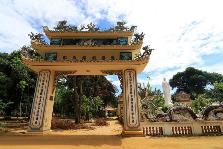
Hang Pagoda (Thien Khong Thach Pagoda) also has the folk name "Kong Khong Pagoda" located northeast of Re Island (Lon Island) in An Hai commune, Ly Son island district. The unique architecture of Hang Pagoda was not built by human hands but by the magic of creation. Not built of wood, bricks, lime, or mortar, Hang Pagoda is simply a stone cave deep into the foot of Thoi Loi mountain (Ly Son district, Quang Ngai province). Hang Pagoda is the largest natural cave in the cave system in Ly Son, formed during the seaward period, about 4,500 years ago. From the wave marks around the foot of Thoi Loi mountain, rising significantly above the current tide level, especially the rocks in front of Hang Pagoda are vivid evidence of the phenomenon of ocean waves eroding into fine-grained sediment layers. , rocks and carbonate mud. The notes of French archaeologist Parmentier, oral tradition and a few remaining traces show that Hang Pagoda was originally a stone cave that the Cham people used as a place of residence or worship. before the Vietnamese set foot on Ly Son island. The genealogies and legacies of the first families to explore An Hai village show that about 4 centuries ago, during the reign of King Le Kinh Tong, Mr. Tran Cong Thanh and the ancestors of An Hai village were the initiators of this work. renovated and expanded the cave, turning this place into a Buddhist temple. Later, descendants of the Tran family added the spiritual relics of the Zen sages of Ly Hai village to the pagoda to worship. According to the genealogy of the Tran family, the family that oversees Hang Pagoda, this pagoda is about 300 years old. During the time when pirates (Tau O invaders) were harassing, Hang Pagoda was a safe hiding place for people. Inside the pagoda is a cave 24m deep, 20m wide, 3.2m high, and there are many nooks and crannies. Legend has it that in the past, this was the road to the underworld. According to the concept of good and evil going hand in hand, the main space of Hang Pagoda is for the good and those who know how to repent. On the contrary, if the guilty person refuses to turn back, they will be banished to the underworld in a smaller cave next door. Before there was a concrete road running to the top of the slope down to the pagoda, to get to the pagoda, one had to follow the difficult mountainside. The part of the mountainside facing the sea is called the meow, and is where many unfortunate people slip and fall onto the rocks and are injured or even lose their lives. From the foot of Thoi Loi mountain in the Southeast, around the mountain ridge in the Northwest, then following the stone steps down gradually, closer to sea level, visitors will see rows of banyan trees towering in front of the pagoda yard. (square almond tree) is hundreds of years old. Looking up is the windy ocean, looking back is the "heavenly rock cave", looming in the distance is Bo Bai island. In front of the majestic stone pagoda is a full-body statue of Avalokiteśvara Bodhisattva with benevolent eyes facing the ocean as if containing sympathy for sentient beings. Lightly step into the temple, which is also a stone cave, amidst the faint smell of incense, a dim candle shines into the gloomy light and darkness, it takes a moment to calm down, eyes get used to the darkness, to recognize to the altar to worship Tam The Buddha, Amitabha Tam Ton, Hoa Nghiem Tam Thanh and the bodhisattvas, patriarchs, and sages who publicly destroyed An Hai village and Ly Son district. Like all other Buddhist temples, the largest number of people coming to worship and pray to Buddha at Hang Pagoda is on the occasion of Lunar New Year, Nguyen Tieu, Buddha's Birthday, Vu Lan and the days of worshiping, wishing, worshiping Buddha, Bodhisattva... Especially In particular, Ly Son fishermen, whether they are Buddhists or not, come here to worship very solemnly and seriously on Bodhisattva Avalokiteśvara days or before entering the fishing season (sea gate opening). . Source: Vietnam National Tourism Administration
Quang Ngai 1866 view
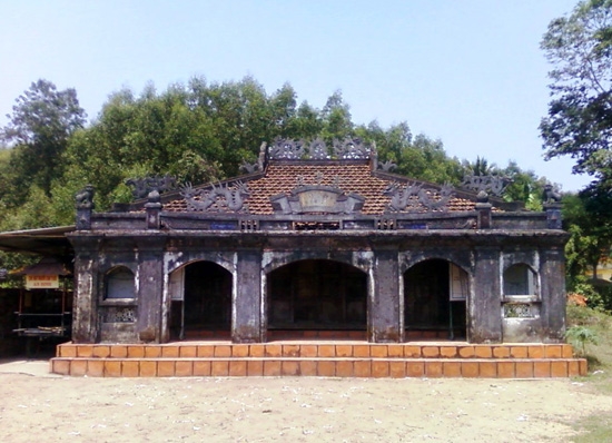
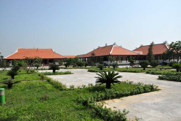
An Dinh village communal house (An Dinh village, Hanh Dung commune, Nghia Hanh district) was built in 1820, with contributions from seven ancient families: Tran, Nguyen, Pham, Huynh, Vo, Phan, Le and villagers. to create. An Dinh village communal house not only has a rich history and is imbued with the nation's cultural identity, but is also a unique work of art. Over time and the changes of history, An Dinh village communal house has become a traditional cultural symbol of Vietnamese villages. The communal house is located on the highest and most beautiful land in the village, surrounded by rows of ancient trees, with a total area of 5,372 square meters. In which the construction area of the communal house is 204m2. An Dinh communal house has undergone four restorations. In particular, in the second restoration period (1875), the communal house was rebuilt almost completely and has the same overall architecture as today. The communal house has a bold architectural style of the Nguyen Dynasty, reflected in a very unique wood carving technique. From the outside in, the architectural works are arranged in an inverted T-shaped axis. The main side of the communal house faces south. The embossing technique of visual art is expressed by artisans very sophisticatedly and vividly. An Dinh village communal house is one of the typical architectures in the village and commune architecture of ancient Quang Ngai people. The communal house takes on the role of both a cultural center and a common place of worship for the community, the administrative headquarters of the government, the village, and the place to handle all matters related to village members. In addition, the communal house also reflects the ability to conquer and build the homeland with the hands and creative minds of our ancestors, absorbing the knowledge of communal house building from the Red River Delta with a truss structure throughout the gong rack, stack of beds with gong shelves, developed into new structural elements with local elements, suitable for climatic conditions so that it is both dignified, spacious and unique, contributing to the traditional cultural identity of the country. Quang Ngai land. An Dinh village communal house has an important position in spiritual life, as a place to worship the ancestors of seven ancient clans that contributed to creating this land. Every year, at An Dinh village communal house, festivals take place such as: Communal ceremony with color procession (February 15), Thanh Minh (March 16), Lady Ngoc festival and harvest festival (August 2). The festival also operates according to general regulations on musical ceremonies of feudal dynasties, especially the Nguyen dynasty. But festivals also partly originate from everyday activities that suit local needs and certain cultural traditions. Furthermore, An Dinh village communal house also shows a unique, appropriate, and harmonious overall architecture from the Northern communal house style and the Central truss house style still remaining in the province. During the years of fierce war, especially during the two resistance wars against the French and the Americans, An Dinh village communal house was the site of secret activities of the revolution. This is where senior officials of the Party Committee and the Inter-Region 5 government meet to discuss battle plans. Not only that, officers, soldiers and people of An Dinh also dug a tunnel from An Dinh communal house to the riverbank to serve as a place to hide soldiers, wounded and sick soldiers. An Dinh village communal house is also a secret medical facility to treat injuries for officers, soldiers and people. An Dinh communal house has witnessed many ups and downs of history. The communal house embodies the will and strength of the Vietnamese community in building villages, and is a place where the traditional cultural beauty of the Vietnamese people converges. An Dinh village communal house has gone deep into the hearts of many generations, becoming a nostalgic memory for people living far away from home, wholeheartedly aiming for love for the Vietnamese countryside. An Dinh village communal house was recognized as a national historical, cultural, architectural and artistic relic in 2018. Source: Quang Ngai Newspaper
Quang Ngai 1859 view
Chau Sa Citadel or Hoi Citadel, located in the downstream area, left bank of Tra Khuc River, in Son Tinh district, Quang Ngai province. The south borders Tra Khuc river, the north borders Ham Giang river, the east borders Dinh field and the west borders Ban Co mountain. Chau Sa ancient citadel was built by the Champa people in the 9th century to protect the south of the capital Tra Kieu. According to the information recorded on the stele, Chau Sa Ancient Citadel was built in 903. After the king of the 5th dynasty of the Champa kingdom, Java Vikrantavarman III, passed away, Sri Indravarman II became the successor. The new king moved the capital from Panduranga (now Ninh Thuan) to Amaravati (now Quang Ngai) and established the Indrapura dynasty (Cham Thanh). Then, in the south of Indrapura, the Cham people built Chau Sa citadel, an important defensive structure of the Champa empire, with the goal of preventing and preventing uprisings and invasions from other states. . Chau Sa Citadel was once the capital, economic, cultural and political center of the prosperous Champa kingdom. This was a place of bustling trade between the Champa kingdom and neighboring countries during the late 9th and early 10th centuries. After the Champa kingdom weakened, Chau Sa Ancient Citadel continued to experience many upheavals in Vietnam's history. In 1471, after King Le Thanh Tong expanded his territory to the South, Chau Sa citadel became an important military post until Quang Ngai citadel was built in 1807. Before 1975, Chau Sa citadel was officially established. Saigon government used it as a military post and named it Son Thanh post. Chau Sa ancient citadel is an architectural wonder built of earth on a large scale, including two layers of citadel: inner citadel and outer citadel. Each of these citadels has unique architectural features and plays an important role in the historical development of the Cham people and the Champa kingdom. 1. Inner citadel. The inner citadel has a total of five doors, each door is located in the East, West, South, North and Southwest directions. These gates are built of brick and have raised gazebos. In particular, the southern gate was carefully dug and reinforced and is considered the main gate of the citadel. With its special terrain and strategic location, it has created a solid defense system for Chau Sa Ancient Citadel. Chau Sa citadel also has two citadels called "crab claws", connecting the inner citadel with the largest river of Quang Ngai province, Tra Khuc river. 2. Outer city. The outer citadel was skillfully built by combining excavation and taking advantage of the natural terrain of the area. The outer citadel uses low hills, rivers, canals, and ponds in the area to create a fortified system, protecting Chau Sa Ancient Citadel from outside threats. The outer citadel was only built with three ramparts in the West, East and North directions. The western and eastern walls of the citadel were built firmly and solidly, while the northern side mainly relied on the mountains. The south side has no protective wall, overlooking the Tra Khuc River. Many ancient ceramic artifacts and Go Pho ancient tower were also found here, showing that the citadel was once a pilgrimage destination for Brahmin believers in ancient times. On the outskirts of Chau Sa, many artifacts called "quails" were also found, shaped like playing cards worn on the body. Inside the citadel there are also many beautiful Buddhist miniatures made from terracotta. In 1994, Chau Sa ancient citadel was recognized as a national relic. Source: Collection of Quang Ngai tourism newspaper
Quang Ngai 1838 view


 vn
vn en
en ja
ja ko
ko zh
zh VIP member benefits