Explore the history, culture, people and beautiful landscapes of Vietnam on the 63Stravel travel app
Download the 63stravel app


Yen Bai 357 view

Download the 63Stravel app to immerse yourself in countless beautiful photos of Vietnam
Cycling around the village and admiring an impressive natural picture
Opportunity to experience a day of Thai ethnic people
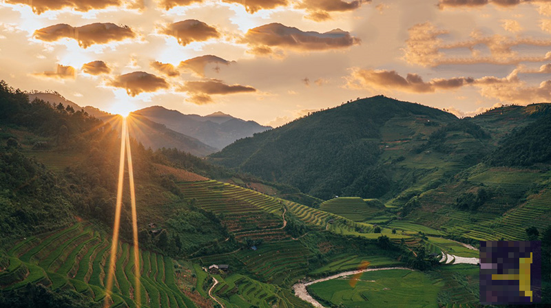
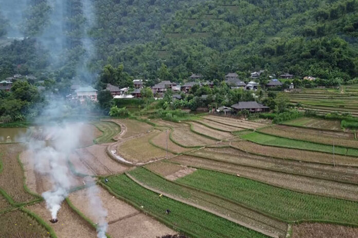
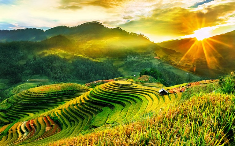
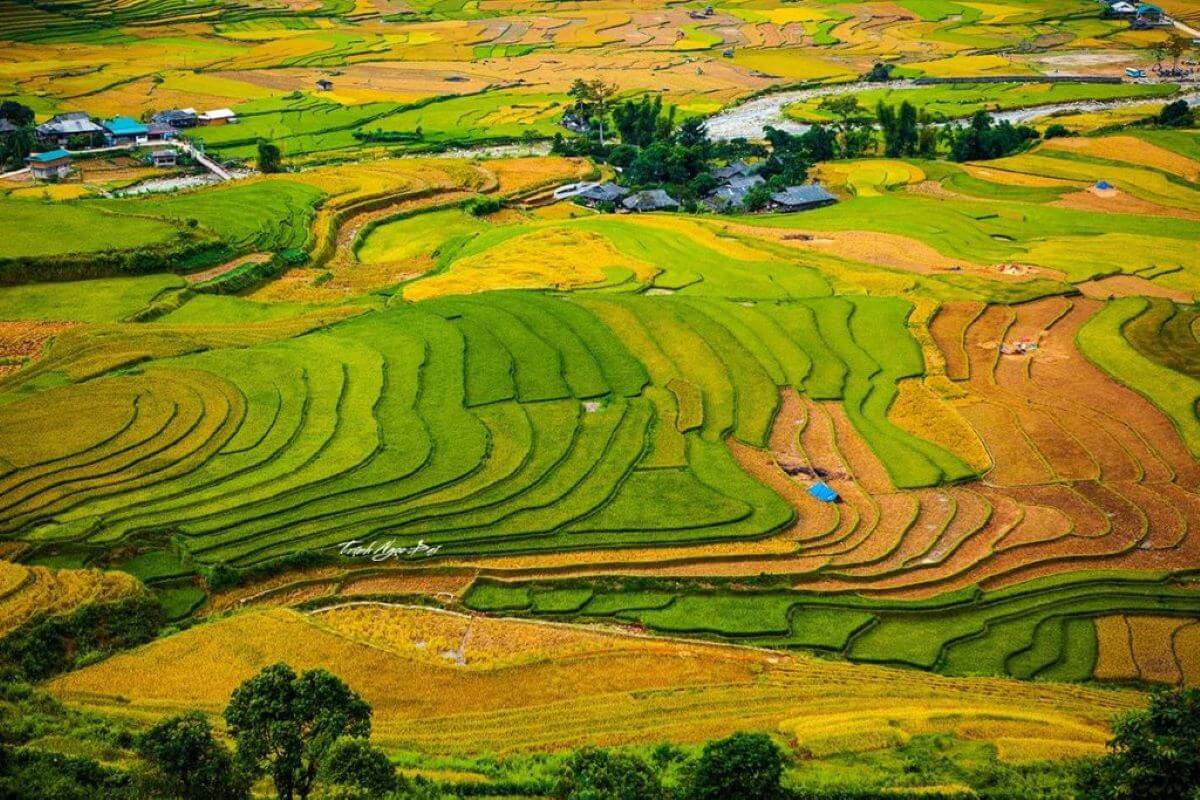
The terraced fields are vast and picturesque
The village is one of the places especially loved by foreign tourists
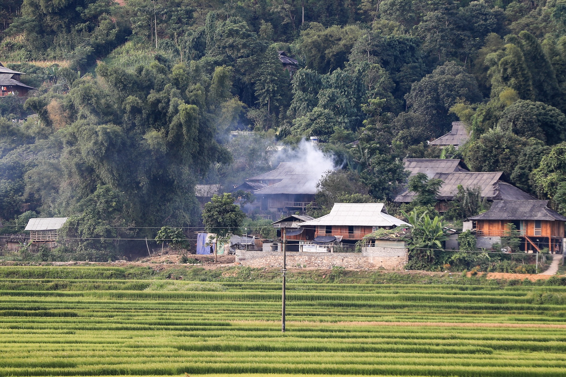
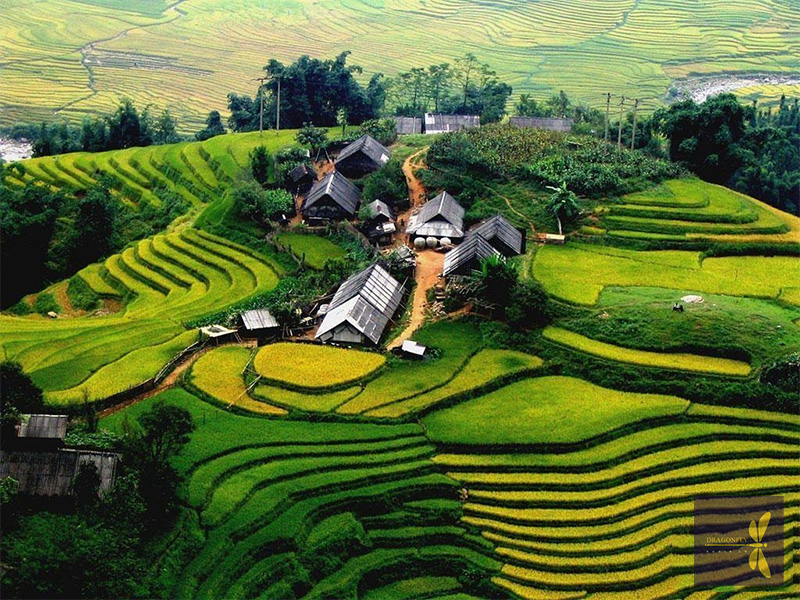
Pristine village in Muong Lo valley
The simple lifestyle of the people in Ban Chao Ha and the surrounding area of Muong Lo.


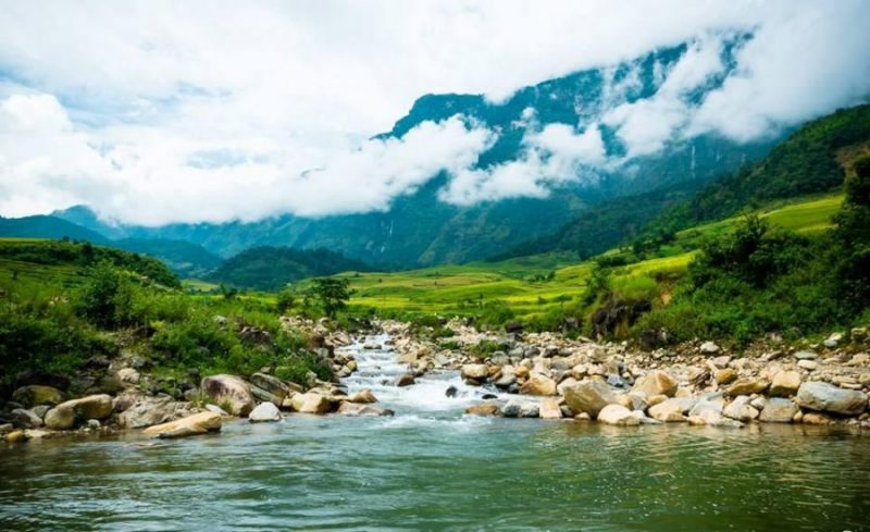
In recent years, every year, around the end of September and beginning of October every year, tourists from all over the country flock to Mu Cang Chai to admire the wonderful scenery of the highland land. This. Coming here, visitors can not only enjoy the beauty of terraced fields and the sea of white clouds on top of Cao Pha pass but also immerse themselves in the unique cultural festivals of the Mong people. Mu Cang Chai is a western highland district of Yen Bai province, 180km from Yen Bai city center, more than 300km northwest of Hanoi capital. This land is located at the foot of the Hoang Lien Son mountain range, at an altitude of over 2,000m above sea level. Coming to Mu Cang Chai, visitors can take Highway 32 in two directions. If from Hanoi, you will go to Yen Bai, from Yen Bai to Muong Lo 70km, sleep here so that you can drive from Muong Lo early tomorrow morning and arrive at Mu Cang Chai in the afternoon. This section is nearly 100km long, but more than 80km is a steep mountain pass that continuously advances. Once it reaches an altitude of 1,750m, covered with mist and clouds, it will soon reach Mu Cang Chai town. In the middle of the pass, there is a flat land, stop here to enjoy the fragrant Tu Le sticky rice that is famous throughout the region. In the second direction, tourists go all the way to Noi Bai - Lao Cai highway, go to Sa Pa and pass O Quy Ho pass, then go through Tan Uyen and Than Uyen of Lai Chau to reach Mu Cang Chai. Coming to Mu Cang Chai even once, visitors will feel the richness of nature, the uniqueness of culture, and the warmth of human love. The road to Mu Cang Chai is far and difficult, but very interesting. The scenery changes constantly on the road. Tourists have not yet had time to see all the Thai stilt houses on the vast Muong Lo field with countless white daylilies before they have reached the winding, meandering roads on the steep hillsides. stand. Geological movements have created high peaks for Mu Cang Chai such as: Pung Luong (2,985m), Phu Ba (2,512m), Mo De (2,100m)... Through Khau Pha Pass (2,100m high), this is The highest mountain peak in the "four great passes" of the Northwest is covered in a sea of floating clouds, with a cool climate all year round. The top of Cao Pha Pass is also the 4th most beautiful place in the world for paragliding pilots, for those who love thrills and adventure games to conquer the sky and enjoy admiring. Explore the majestic natural beauty of heaven and earth from the air through paragliding. From here, from pass to pass, mountain to mountain, visitors will clearly feel the change in altitude. On both sides of the road are beautiful terraced fields that make each of us feel stunned. overwhelmed. The beautiful small town of Mu Cang Chai is nestled between two mountain slopes with peaceful villages in the green valley or on Khau Pha pass. Accounting for 90% of the district's population, the Mong people in Mu Cang Chai have 4 groups: Mong Do (White Mong); Butt Swing (Black Butt); Mong Linh (Mong Hoa); Mong Si (Red Mong), they reside on mountain slopes from 800 to 1,700m high with rich traditional and unique cultural features that always attract many researchers. Coming here, visitors can visit Mong ethnic villages, explore the culture and customs of the Northwest highlands with many unique folk cultural and artistic values and famous products. language. Watch the Khen dance, go with Mong boys and girls to the Sai San festival, experience some traditional crafts such as blacksmithing, flax weaving, jewelry making and enjoy traditional dishes of the Mong people. . In particular, tourists cannot miss and visit Thai village, just cross the bridge right in the center of the district (towards Che Tao commune where there is a conservation area for ornamental species) and then turn left about 1km to get there. Thai version. A small peaceful village located in the middle of the valley, its back leaning against the mountain. Here, visitors will enjoy Thai specialties, take a herbal bath in the traditional Thai way, rest in a stilt house and organize exchanges, light a campfire, and dance. Coming to Mu Cang Chai, visitors can enjoy the beauty of the Mu Cang Chai National Scenic Rice Terraces complex with a total area of 330 hectares distributed mainly in 3 communes Che Cu Nha, La Pan Tan and De Su Phinh, The place has been recognized as a National Landscape by the Ministry of Culture, Sports and Tourism since 2007. The terraced fields here are as beautiful as the fingerprints of heaven, an artistic architectural work full of creativity from the couple. the skillful hands of the Mong people. Not just now but for a long time, the harsh land of Mu Cang Chai with the meaning of "dry tree village" in the Mong language has become a symbol of human diligence and persistent creativity. From an arid, deserted land, the Mong people who are good at climbing passes and crossing mountains have cleverly turned each bed of land and each hill into beautiful terraced fields, not only providing a source of food to feed the community but It also adds highlights to nature, turning wild mountains and hills into unique masterpieces imbued with the traditional cultural values and creative feats of the Mong people. The fields are level by level, each level hugs the mountain slopes. Throughout the 13 communes and towns of Mu Cang Chai, there are terraced fields. The terraced fields are most beautiful in May-June when the fields are in the flood season and September-October when the sticky rice is ripe and shiny golden spreading across the hillsides. Tourists come to Mu Cang Chai at these two times to witness firsthand the green and yellow raspberries appearing among the vast hills and mountains. Stopping at the three communes of La Pan Tan, Che Cu Nha and De Su Phinh, everywhere visitors can see terraced fields spread across the hills. Visitors will not be able to help but admire, admire, and appreciate the glorious brocade painting between heaven and earth woven by the "peasant artists" of the Northwest. This entire mountainous area is a beautiful picture of the Northwest highlands painted by blue sky, white clouds, high fields and a simple, simple but realistic life down to every look and smile. laugh.
Yen Bai 1893 view
May to June
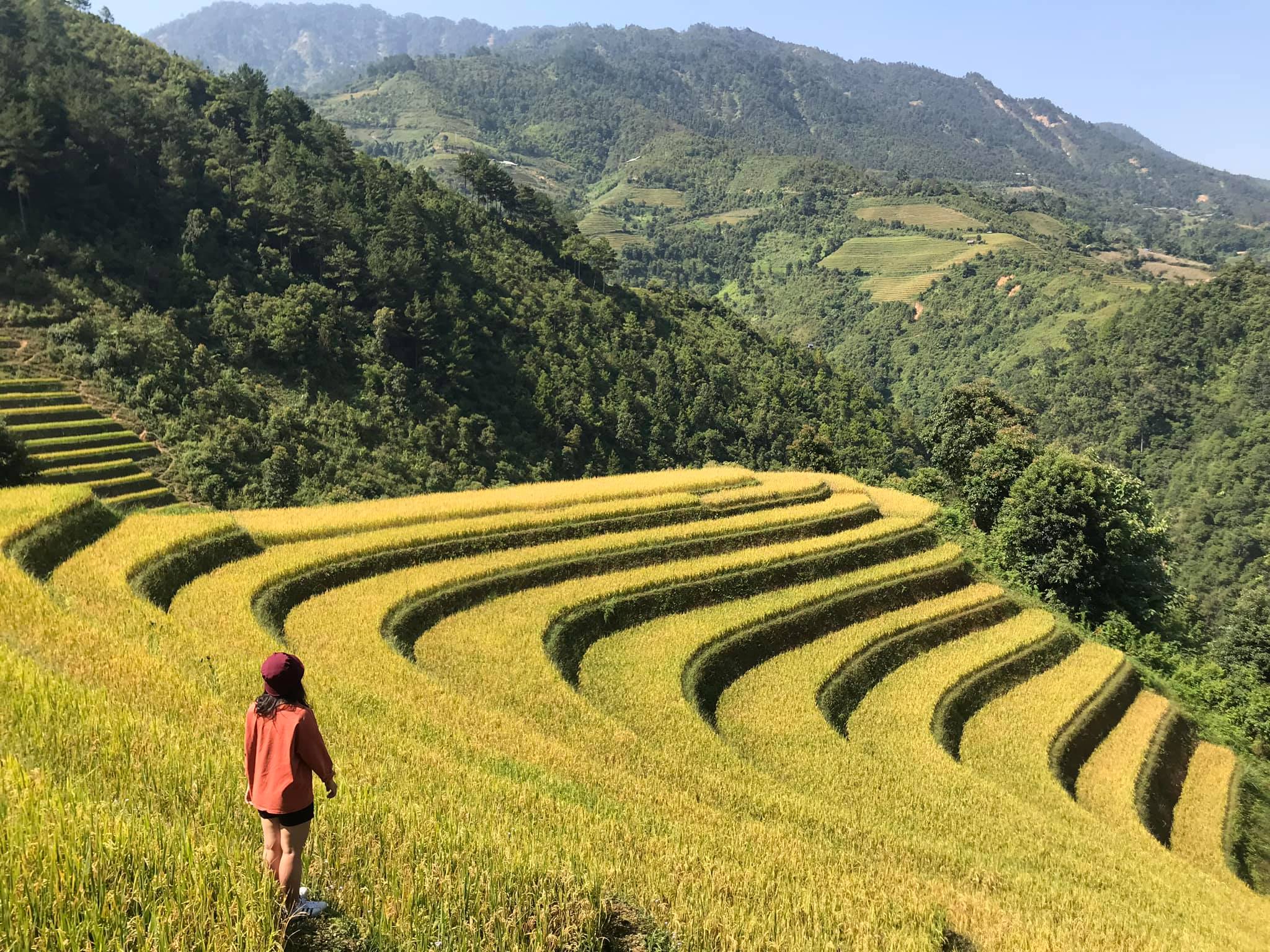
La Pan Tan is a highland commune in Mu Cang Chai district, Yen Bai province. With its location on the top of Khau Pha, nearly 2000 meters above sea level, La Pan Tan commune possesses an extremely beautiful natural picture with terraced fields, towering mountains and indigenous culture. H'mong people. From Mu Cang Chai town to La Pan Tan commune, about 15km, visitors can easily reach the destination by going in the Northeast direction. After the journey through the mountain passes, you will come to a beautiful land with up to 2,200 hectares of terraced fields arranged in layers. In the past, La Pan Tan commune used to be a poor commune, the "capital" of opium when up to 80% of the population was addicted. However, that "dark" period has gradually passed when the commune received adequate investment to develop tourism. The lives of local residents have gotten better. In 2007, La Pan Tan was recognized by the Ministry of Culture, Sports and Tourism as a National Scenic Monument. With a prime location in the high mountains, cool climate and average temperature of about 19 degrees Celsius, this place has become a favorite destination in Mu Cang Chai for many tourists. The journey to explore La Pan Tan commune brings you countless memorable experiences in both the beautiful scenery, culture and people here. If you discover La Pan Tan commune for the first time, you will probably be immediately overwhelmed by the beautiful scenery here. On the journey to visit this Northwest highland commune, visitors will enjoy the beautiful scenery of terraced fields surrounded on all sides. As one of the communes with the most terraced fields in Mu Cang Chai, everywhere you look you will see rice fields overlapping. It is truly admirable for the farmers here, with their human strength and rudimentary agricultural tools, they can turn the mountains and hills into beautiful fields, curving beneath the mountain slopes. Terraced fields lie gently along the hillsides, extending to the stream banks, weaving into the villages. Everywhere are rice fields. Exploring La Pan Tan commune, visitors can check in many beautiful places here. Among them, Mam Xoi hill is the hottest coordinates of each ripe rice season. This hill is supported by terraced fields below, and above has a round shape like a tray rising to the sky. Every golden rice season, Mam Xoi Hill attracts many tourists to check in and take photos. According to the experience of many tourists going to Mu Cang Chai, Mam Xoi Hill is most beautiful in the early morning at dawn when the golden sunlight has just gently crept onto the fields, surrounded by white mist covering it, painting a picture. beautiful like a fairyland. Near Mam Xoi hill, there is a small wooden shack owned by local people, where visitors can sit and admire the scenery and enjoy taking photos. Visiting La Pan Tan during the ripe rice season in September - October, visitors can both admire the beautiful terraced fields and have the opportunity to watch people harvest rice manually. The image of Hmong women with small sickles quickly harvesting each clump of rice in the field is so beautiful and simple. Coming to La Pan Tan, Mu Cang Chai district, in addition to terraced fields, visitors can also explore the beautiful waterfall here. That is Pu Nhu waterfall with a height of more than 20 meters, pouring loudly into Dragon Lake and creating a very majestic and mysterious scene. Around Pu Nhu waterfall are large and small rocks covered with moss, leading to a peaceful, poetic forest of ancient trees. Coming to Pu Nhu waterfall, you can spend time admiring the beautiful scenery, taking photos or camping around the lake shore. Indigenous people believe that Dragon Lake is a sacred place so no one goes to bathe. However, later when local tourism activities are promoted, visitors can experience bathing in the waterfall to feel the cool water here.
Yen Bai 1628 view
September to October
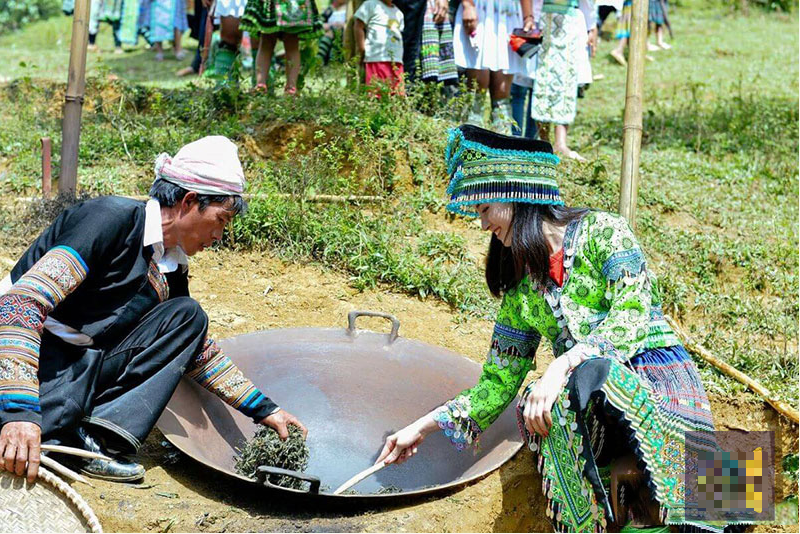
Yen Bai Giang Stream is located at an altitude of about 1,300 - 1,400 m above sea level, covered by layers of clouds all year round, plus the air is always extremely fresh and cool, making this place a hot spot. The spot is very popular with tourists, choosing it as a place to stop. Besides, this place also has a unique feature that MIA.vn believes that when you hear it, you will want to pack your things and go to Suoi Giang immediately, that is, you can feel all four seasons of the year in just one breath. in... a day in Suoi Giang. When mentioning Yen Bai, it is impossible not to mention Suoi Giang, and when mentioning Suoi Giang, it is impossible not to mention Shan tea. Stop here for a moment to let MIA.vn tell you a fairy tale about this type of tea associated with Suoi Giang. Legend has it that, once upon a time, a fairy sowed seeds in Suoi Giang and this divine seed germinated into a lush green tree. When the tree grows, it spreads its leaves and buds as white as snow. At this time, the Mong people living here were suffering from hunger and cold. They used this leaf to eat. After eating, their bodies felt healthier. It was that miracle that they believed that God had helped them, so they decided to establish a village here to live and call this place Suoi Giang. It must be said that the ancient tea trees in Suoi Giang are also very magical, they live at an altitude of 1,400 meters above sea level, the "young" trees are over a hundred years old, the older trees are over 300 years old. Yet young buds still grow green on rough, moldy white tea stems, firmly clinging to the roots on the craggy mountainside, creating a unique ancient tea garden landscape. In addition, those fat tea buds are covered with a translucent white layer, so they are called snow tea. Tea is picked and prepared with the experience and skillful hands of the Mong people. Shan Tuyet Suoi Giang tea is very unique. Although it lives in a pristine mountain area, the green tea contains all the top flavors of world-class teas in the bowl. When traveling here, there are many activities for you to enjoy this green, clean, and beautiful living space, such as closing your eyes and thinking about a bowl of fragrant tea, or carelessly drinking a cup of tea. Sleep soundly under the canopy of a huge tea tree, or immerse yourself in the lives of the people here through tea picking and tea making activities, and finally enjoy the tea that is a finished product that you have made with your own hands. It is truly an ideal destination for us to "detox" the fatigue and worries from life in the city, isn't it! Traveling to Suoi Giang, in addition to enjoying Shan tea, there are also many specialties of the Mong people waiting for you to enjoy such as: men men, Yen Bai kitchen buffalo meat, armpit pig, wild vegetables, cassava wine, corn wine,... and extremely unique dishes, blended with the flavor of ancient sweet soup such as meat rolled in grilled tea leaves, young sweet soup leaves eaten raw with herbs. The cuisine is simple and rustic but has an unforgettable flavor. Imagine sitting comfortably at the wooden dining table, in the cold weather of a quiet night, enjoying hot grilled meat skewers, accompanied by the strong aroma of wild vegetables, the heat of a bowl of wine and wine. Occasionally "coating" your mouth with the sweet taste of men men made from corn, it will definitely make you want to take a once-in-a-lifetime trip with your best friends.
Yen Bai 1650 view
From January to December
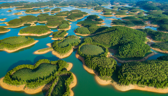
Located in the Northwest of the country, Thac Ba Lake of Yen Bai province, a place called "Ha Long on the mountain", is one of the three largest artificial lakes in Vietnam formed when the Thac Ba Hydroelectric Plant was built. The lake is located in two districts of Yen Binh and Luc Yen. The lake has nearly 20 thousand hectares of water surface, including more than 1,300 large and small green islands, along with a beautiful cave system hidden deep within the limestone mountains. Coming to Thac Ba Lake, visitors can enjoy watching the vast sea of water and the immense islands of trees reflecting on the blue lake surface. The people here are also very friendly and hospitable. Anyone who has once visited Thac Ba Lake will surely be surprised and will never forget the clear, poetic and majestic Thac Lake. Not only does it provide water to generate electricity from the national grid, Thac Ba Lake is also a place for fresh air conditioning and a stopping point for tours. Visiting Thac Ba Lake, when traveling by boat, visitors will enjoy the fresh air amidst the vast, shimmering water surface reflecting the seemingly endless overlapping islands, forgetting all the tiredness and worries. troubles of life. The first place visitors can visit is the Thac Ba Hydroelectric Plant area, where Thac Ba Temple is located, this is Vietnam's first hydroelectric project standing tall on the lake. Having the chance to visit the country's historical works with their own eyes and hear the story of the people who devoted their lives day and night to building the factory, each visitor will be moved and more proud of the glorious national tradition. , the sacrifice of his father's generation. At the end of the trip to visit Thac Ba Hydroelectric Plant, visitors can also visit Thac Ba Mau Temple - a spiritual tourist destination not far away. The temple is located on Hoang Thi mountain, with its back against the mountain, overlooking the Chay River in the East Northeast direction, far away is Cao Bien Mountain. For a long time, Thac Ba Mau Temple has been famous as a sacred place, recognized as a Provincial Cultural and Historical Relic in 2004. Tourists visiting Mau Temple light a stick of incense, letting go of the chaos of life. , praying for peace of mind at the door of compassionate Buddha to continue the journey that takes visitors to discover the magical beauty of stalactites, of strange natural stone statues that hide many human desires and ambitions in the world. Limestone cave complexes on the lake such as: Thuy Tien cave, Xuan Long cave, Bach Xa cave, Thac Ba, Thac Ong... Thuy Tien cave, located in the heart of the rocky mountain is about 100m long with sparkling, clear stalactites. It has a picture of nine fairies, each with a unique look associated with a thrilling and attractive love legend. Visit Xuan Long cave hidden in the rocky mountains, with natural stone statues and stalactites associated with colorful legends. Along with the cave system, visitors can go up Cao Bien Mountain, the largest and longest mountain range of Thac Ba Lake. Standing on the top of the mountain, you can see the lake engulfed in mist with its shimmering and magical beauty. , feel the majestic beauty of nature, to find the ancient mark of Ngoc market, the famous Thac Ba Ivory market, once a bustling market... Sitting on a canoe up the Chay River, not far away, visitors will Visit the land of Ngoc Luc Yen with famous landscapes such as Sao Pagoda cave, Dai Cai temple... and admire the magic of natural gemstone paintings under the talented hands of craftsmen. Charming scenery, rich in aquatic resources, the lakeside is also home to many ethnic groups such as: Kinh, Tay, Nung, Mong, Dao, Phu La, Cao Lan... People here still keep local cultural identity, in which many special festivals often take place such as the New Rice Festival of the Tay people, Tet dancing of the Dao people... Coming to Ngoi Tu Cultural Village - Vu Linh commune, Yen Binh district, where 5 ethnic groups gather (mainly White Dao people), visitors will experience a relaxing life under low stilt houses. Wander among the palm forests, learn about the traditional craft of weaving shrimp baskets, and watch red-cheeked Dao girls in brilliant national costumes. In particular, every time night falls, by the flickering campfire, visitors will hear captivating folk songs and enjoy the delicate flavors of dishes such as: bamboo-tube rice, banana flower salad. forests, chicken cooked with sour bamboo shoots or fish salad, shrimp salad... Most of the villages along Thac Lake still retain their wild features, along with the cultural identities of the Tay, Nung, Dao, and Cao ethnic groups. Lan... with many unique festivals. Currently, Ngoi Tu village has many fully invested households qualified to welcome foreign guests. Every year, the village welcomes hundreds of groups of visitors, mainly from Germany, France, Italy, Sweden, Australia and overseas Vietnamese. In addition, visitors can also attend the unique boat racing festival called "Echoes of Thac Ba Lake" or visit the famous Kha Linh grapefruit village. And on that journey of discovery, visitors can also spend a little more time to visit the adjacent land of Luc Yen, a famous gemstone area in the country, visit the historical relics of Dai Cai temple, Ma Mut cave, and Sao pagoda. , Black King Mountain... where archaeologists have discovered traces of ancient Vietnamese people. Compared to Ha Long Bay on the mountain - Thac Ba Lake promises to bring tourists wonderful, unforgettable experiences.
Yen Bai 1943 view
From January to December
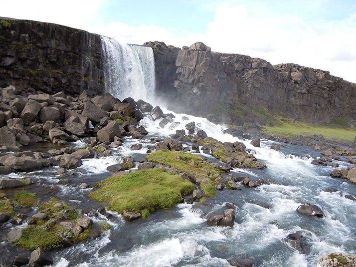
Yen Bai province is known to many people thanks to the impressive beauty of its charming natural scenery, the most famous is probably Mu Cang Chai. But few people know that this is also the place where the endless echo of the majestic and beautiful Pu Nhu waterfall is heard. Pu Nhu Waterfall is located in Pu Nhu village, La Pan Tan commune, Mu Cang Chai with the waterfall creating melodious sounds like a proud story about the honest, simple people of the majestic high mountains of the West. North. The waterfall is located about 10km west of the center of Mu Cang Chai district, originating from streams in the upstream forests of Lao Cai and Son La. The extremely impressive high mountain terrain here has turned that stream into the majestic, impressive waterfall it is today. The most special thing to mention is that during the flood seasons, the water here is compensated with a layer of fertile silt to help the plants grow, bringing fresh flavors and full of vitality. Nature is very clever in delicately surrounding this beautiful waterfall, only "revealing" the majestic echo of the waterfall to those from afar. That's why Pu Nhu waterfall becomes more mysterious, making everyone curious to discover it just by hearing those sounds. Before you can see Pu Nhu waterfall, you will already be ecstatic about the poetic beauty of the path leading there. The road is quite easy, just passing through the stream and cornfield, you can enjoy the cool feeling of the cool water here. If you choose to travel along the main road, it will be difficult to admire this waterfall. Do you know why? Because nature has embraced this waterfall with tall forest trees, creating a delicate hiding place for the waterfall. With a height of about 200m, the waterfall is divided into many different levels. The most beautiful is on sunny days, the Pu Nhu waterfall flows down like a white silk cloth fluttering to the joyful melodies of the whispering wind and the singing of birds in the surrounding pristine forest. If you have the opportunity to explore Mu Cang Chai on days with such great weather, you will surely admire the pristine beauty, majestic sounds and the most memorable moment is the moment of immersing yourself in the fresh air. that heaven and earth bestowed on this place. Standing proudly between two high vertical cliffs, Pu Nhu waterfall appears like a watercolor painting. The image of the majestic high mountain is like a mighty man surrounding and protecting the beautiful young woman named Pu Nhu waterfall through many ups and downs of life. Around the waterfall, there are also large rocks covered with moss that are somewhat scary, but that is also a special highlight that makes you unable to take your eyes off the strangeness. If you are struggling to find a place to let go of all your worries and relax in the fresh nature, this is truly the ideal place for you. With what Pu Nhu waterfall possesses, you will surely have a memorable trip with wonderful and impressive scenery here. Beneath the continuously flowing water of the waterfall there is also a mysterious lake called Dragon Lake. According to the people here, this lake is extremely sacred because there is a dragon sleeping at the bottom of the lake, and it is said that the Pu Nhu waterfall is the beautiful result gushed out from that dragon. Although it is only a story that has been passed down orally to this day, it has made people not dare to immerse themselves in this water, because no one dares to wake up the dragon's sleep. However, this is just a legendary story. Nowadays, tourism services here have become much more developed, you can be completely guaranteed safety during your visit. Therefore, you can still enjoy the cool water here without having to worry too much.
Yen Bai 1643 view
From January to December
Lim Mong village is located in Mu Cang Chai district, Yen Bai, with a beauty that has captivated the hearts of many people. Lim Mong village is located at the end of Yen Bai, blessed by nature with breathtaking beauty and stretching rice fields, interspersed with roofs that appear hidden in the clouds, as beautiful as paradise. . It is no exaggeration to say that Ban Lim Mong is one of the extremely challenging attractions and discoveries for those who are passionate about backpacking. With an extremely dangerous road full of hardships and challenges, Ban Lim Mong responds to everyone's patience with a breathtakingly beautiful natural scenery, not inferior to Tu Le Town in Yen Bai. Between September and October is the best time for you to explore Ban Lim Mong. This is also the time when Mu Cang Chai terraced fields are at their most beautiful season. Coming here at this time, you will admire the natural scenery of Yen Bai dressed in shiny golden colors, as beautiful as a picture painted by the hands of Mother Nature. If you missed Yen Bai's golden season, you can also visit Ban Lim Mong around May to June. At this time, Yen Bai is in the flood season, so the natural scenery is extremely beautiful and poetic. At this time, Ban Lim Mong is also much more cheerful and bustling because people begin to invite each other to go to the fields to plow for a new, bountiful crop. Coming to Yen Bai and missing out on the beautiful natural scenery of Ban Lim Mong is an extremely big mistake. Located at the end of the land of clouds, the road to Ban Lim Mong is also extremely dangerous, making many backpackers restless, wanting to pick up their backpacks to come here to explore one of the most dangerous roads in Vietnam. To get to Ban Lim Mong, from Hanoi you move in the direction of Trung Ha bridge. Coming to Thanh Son (Phu Tho), continue moving straight through Highway 32 towards Yen Bai province. After arriving at the foot of Khau Pha pass, you have to pass through the Thai village at Nam stream to reach Lim Mong village located on the other side of the stream. Right from the time you are on the road to Lim Mong village, you can admire the impressive beauty of Khau Pha pass. With an altitude of up to 1200m above sea level, the spectacularly beautiful Khau Pha Pass brings a significant challenge for those who are planning to explore Ban Lim Mong. Standing from the top of the pass, you will easily admire the natural scenery of Ban Lim Mong. The beauty of Yen Bai's mountains and forests is captured in full view. Especially when Ban Lim Mong is in the ripe rice season, the rice fields stretch out in an extremely bright yellow color, adding to the enchantingly beautiful landscape. Young people often choose the top of this pass as a place to watch Ban Lim Mong, live virtual lives and especially catch the moment of sunset or sunrise. If you intend to explore Ban Lim Mong, one of the first things you need to do is to thoroughly check your vehicle and have it serviced if possible. The road to the village is extremely difficult and dangerous with many steep passes and bends, so if you are not careful, you can easily encounter mishaps in the middle of the road. Make sure you are in good health before leaving because the road to get here is not only long but also full of hardships and challenges. If you are not confident enough to drive, you should go with someone who has a strong handlebar, has experience driving long distances and is as familiar with the roads in Yen Bai as possible. You should check the weather forecast before leaving. If the weather is bad, you should consider changing your itinerary to other destinations before going to Ban Lim Mong. Especially, you should not go down a steep mountain pass at night because the road is very dark, deserted and extremely dangerous for those who are not familiar with the roads of Ban Lim Mong. Prioritize comfortable clothes and sports shoes for ease of movement because most people come to Ban Lim Mong with the desire to explore as much as possible. The terrain here is not suitable for wearing too elaborate dresses and skirts for virtual living.
Yen Bai 1666 view
From September to October
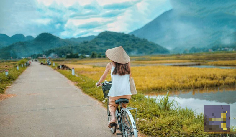
Muong Lo field is located in Nghia Lo town, located on Highway 32, about 80km west of Yen Bai city center. The vast, straight fields are the source of life for the Thai ethnic people, and are also the cradle of culinary culture and traditional traditional dances typical of this land. If Tu Le and Mu Cang Chai are extremely famous with tourists, Muong Lo is still not known to many people. However, this place possesses a very unique beauty that MIA.vn would like to suggest you visit and conquer. You can conveniently go to Mu Cang Chai by Highway 32, then you will pass through Muong Lo Field to explore. Coming to Muong Lo, visitors will be surprised by its extremely peaceful and quiet beauty. The simple small houses, the tall trees, the people who work hard every day, all create a beautiful land. Muong Lo has a terrain like a giant basin, located in Nghia Lo town and a few other communes in Van Chan district. Looking down from above, this place is surrounded by the majestic Hoang Lien Son range, the yellow color of ripe rice and the green color of trees and mountains interwoven together spreading to the horizon. The Muong Lo basin is home to more than 10 ethnic groups including Thai, Muong, Kinh, Tay, Nung, Mong... Therefore, it creates a unique cultural region with unique interwoven features. no two. For a long time, people have called Muong Lo field the land of white rice with clear water and the fragrant flavor of Tu Le sticky rice. Muong Lo rice valley is currently the second largest rice granary in the Northwest region, only after Muong Thanh in Dien Bien province, providing a huge source of food for people here. With a limited economy, mainly dependent on agriculture, Muong Lo plays a huge role in people's lives. Famous as the land of "white rice, clear water", Muong Lo has become the inspiration for many poetic works. With ecstatic beauty, each season appears before visitors' eyes with its own colors and beauty. Because the area of Muong Lo Field is very large and belongs to many localities, it creates a very special scene. At the same time, each commune will have a different farming schedule. On this side, in Nghia Lo, the rice has turned golden, while in Van Chan, the fields are still green. Therefore, creating a very unique landscape of interwoven fields. Every morning when dawn rises, the first rays of light shine down on the vast field. Images of farmers carrying hoes and sickles to the fields to weed and harvest rice, the sound of laughter and talking echoing throughout the sky. As the sky gradually deepened into the afternoon, the boys and girls drove the buffalo back to the barn, the rice flowers sparkled in the sunset, a beauty that was both peaceful and magical that made people's hearts flutter. When harvest season comes, carts laden with rice are returning home. Left behind are fields filled with straw. The smell of straw is strong, dry and yellow under the sun. Coming here this season, you also have the opportunity to participate in local people's new rice festivals, enjoy many delicious dishes and fragrant jars of wine.
Yen Bai 1717 view
From January to December
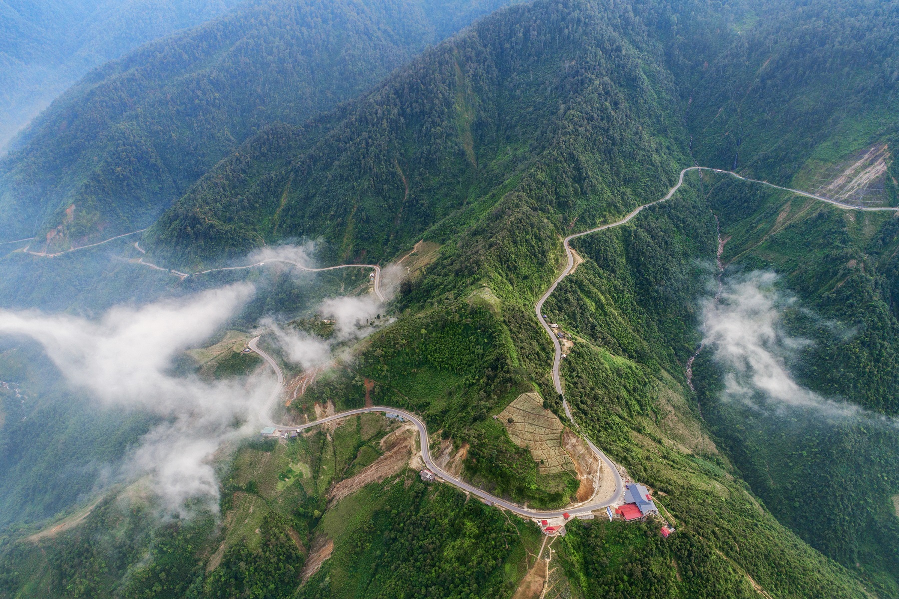
Khau Pha is one of the four most dangerous passes in Vietnam. This place is not only winding and winding with steep cliffs but also precariously surrounded by majestic nature. This pass has a total length of about 30km, at an altitude of more than 1,200 meters and is also the dividing point of Van Chan district and Mu Cang Chai district. Experience exploring Khau Pha Pass on your own: If starting from Hanoi, you should follow Highway 32. On the way to Yen Bai, you can follow Google map, combined with asking people for directions. From Hanoi, you will go through Phu Tho province and then Van Chan district, through Nghia Lo, you will reach Khau Pha pass. Total travel time is about 5 to 6 hours, depending on weather conditions and your driving skills. Two popular vehicles chosen by many people are passenger cars and motorbikes. The advice is that taking a passenger car will help you move more easily and with less effort, while a motorbike will give you the feeling of truly enjoying the mountain roads. If traveling by bus, you should contact and book tickets from reputable bus companies. Do not catch a bus along the way to avoid unwanted risks. If you ride a motorbike, you must carefully check the vehicle's performance. The long distance through the Northwest mountainous roads requires a quality vehicle and a strong engine. According to the experience of most people who have had the opportunity to explore the beauty of Khau Pha Pass, September and October are the most ideal times. In early autumn, the weather here is very cool, a little chilly, and dry, so it is very suitable for tourist activities. At a location of more than 1000 meters, from the top of Khau Pha you will freely enjoy the beauty of Mu Cang Chai Rice Terraces, capturing the panoramic view of the lives of local people, and the most attractive is the journey. Cloud hunting is super fun. To hunt clouds smoothly, you also need a little "fate" with nature here. Usually in the fall and winter, the clouds on the top of the mountain will be very thick, floating, and soft. However, there are also sunny days where the clouds dissipate early, so you won't have a chance to hunt for clouds. However, the view from the top of the pass is extremely perfect, so you can rest assured that your trip, even if you cannot hunt clouds, will not be in vain. In addition, you can also consider coming to Khau Pha in May and June to see the fields in the rainy season. All the fields are like a giant mirror shining under the sunlight, the sparkling water surface makes you captivated. The process of reaching the top of Khau Pha pass will require overcoming 30km of extremely arduous trekking road, with many jagged rocks. Therefore, you need to have a steady handlebar and choose a quality motorbike that operates well to ensure your safety. In addition, on your self-sufficient journey to explore Khau Pha Pass, don't forget to bring a good camera and phone to record super impressive images. The view from the top of the pass is super beautiful, so you will definitely get hundreds of angles shaped like distilled water.
Yen Bai 1923 view
September to October
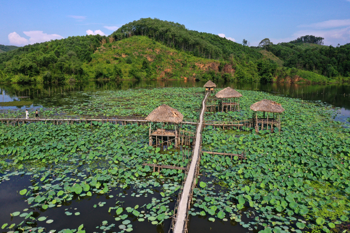
The lotus pond in Van Hoi commune, Tran Yen district, Yen Bai is filled with the fragrance of millions of lotus flowers. This lotus pond has the largest area in Yen Bai province. Coming to the lotus pond in Van Hoi commune, Tran Yen district, Yen Bai province at this time, visitors not only capture poetic and romantic pictures beside the lotus petals, a rustic, pure flower, but also feel the Get closeness and peace from nature. This place has a large lake surface and a peaceful and quiet village landscape. Thanks to those advantages, the lotus pond is known as the most beautiful and largest lotus pond in Yen Bai province. The lotus tree lies deep in the mud, stretching out to show off its fragrance, sometimes brilliant and beautiful, but sometimes shy and gentle. When mentioning the lotus flower, people will immediately think of the elegance, purity as well as the purity of the taste of heaven and earth. The smell of lotus flowers is not as strong as milk flowers, not as attached as roses, but gentle and passionate, the more you smell it, the more you love it. Every June to mid-August, people living here can inhale the scent that is both noble and brings economic value. The pink color of the flowers mixed with the green color of the leaves makes the countryside scene of Van Hoi commune, Tran Yen district even more poetic and attractive. In the cool breeze, the scent of lotus wafts, creating an elegant, gentle feeling. Walking among the brilliant lotus fields, inhaling the pure morning air and immersing yourself in the beautiful nature is an experience that anyone will fall in love with when coming to this lotus pond. Wooden bridges were built along with huts stretching out into the middle of the lake covered with green lotus leaves interspersed with buds, flowers fluttering and blooming, releasing incense in the wind, captivating many people who have come here. Keeping up with the trend, people in Van Hoi commune have renovated lotus ponds into beautiful check-in spots. In recent years, the lotus lagoon has always been bustling with visitors coming to take check-in photos. When the lotus flowers begin to bloom, young women and tourists from inside and outside the district all come to the lotus fields in Van Hoi commune to admire and enjoy the gentle, pure fragrance of the lotus and not forget to save the moments. beautiful engraving. With a large lake surface and a peaceful and quiet village landscape, this lotus pond is known as the most beautiful and largest lotus pond in Yen Bai province. Please come to enjoy relaxing moments and immerse yourself in the fragrant lotus space at Van Hoi lotus lagoon!
Yen Bai 753 view
From May to August.
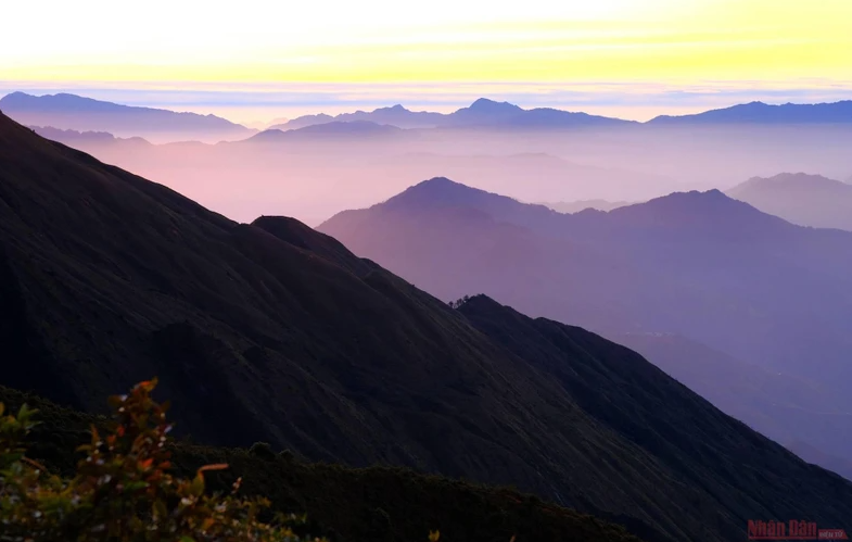
Ta Chi Nhu is the highest mountain in Tram Tau district, Yen Bai province. This place is an ideal cloud hunting place for trekking enthusiasts, ranked 7th among the highest mountains in Vietnam and has a highlight. is a sea of clouds floating above purple mountains. The mountain peak is located in Xa Ho village, Tram Tau district, Yen Bai Province, with an altitude of 2979m and is the 7th highest mountain in Vietnam. At the foot of the mountain are villages of the H'mong and Thai ethnic groups, so the mountain is also called by different names such as Phu Song Sung of the Thai people or Chung Chua Nha of the H'mong people. Here, the scenery is still very wild and the access road is not very easy, so to enjoy the view of the sea of clouds as far as the eye can see, there is only one path, which is to walk from the foot of the mountain to the top, a distance of about 8km. . The suitable time to conquer Ta Chi Nhu is from around September to April of the following year, this is the cold season where clouds easily appear and the air is also cool, with few storms so it is very suitable for the activity. hiking. From around September to early November, this place has a type of grass flower that covers the entire mountain. When the flower blooms, it is purple, so looking from afar to the top of the mountain, you will see the mountain has an extremely dreamy purple color. And even if you get close and stand among the blooming flower bushes, you will be able to take extremely artistic photos. This type of flower is called Chi Pau flower, starting from the story of a tourist who asked the porter who is a native H'mong ethnic group about the name of this flower, the porter replied "chi pau". In H'mong language it means "don't know", due to this confusion the name Chi Pau flower has become more popular among the trekking community. Ta Chi Nhu trekking experience is definitely something you need to bring when coming to Yen Bai. Considered a cloud paradise halfway up the mountain, Ta Chi Nhu always brings a different and exciting feeling to anyone who comes here even for the first time. The Ta Chi Nhu trekking route is considered quite difficult, with many extremely dangerous rocky terrain. After a journey that is not too long but full of hardships and challenges, you will arrive at the surprisingly beautiful mountain top, admiring the scenery of Yen Bai from above. There is a horse shack here where you can stop and rest. The horse shack is located close to a natural water source, so it is very suitable for those who want to camp overnight right at Ta Chi Nhu because they can bathe and cook. One of the attractions for backpackers to conquer Ta Chi Nhu peak is the charming fairy purple flower field. This scene only appears from late October to early November. In the H'mong language, this field is called Chi Pau. The purple color of the flower is not too dazzling, but brings a gentle feeling. You can meet people's horses patrolling, freely grazing in this area. All create a poetic picture, like you are living in a fairy tale. Other specialties of Ta Chi Nhu are the soft sea of clouds and lingering mountain breeze. Clouds stretch from above, covering the entire surrounding space. You will have a clearer view of this scenery when climbing in the dry season. The wind on the top of the mountain is also very strong. Any fatigue you experience during the climb will melt away as you take in the view surrounded by a sea of clouds and a gentle cold breeze. They seem to blow away all the stress and pain. However, prepare warm clothes carefully and don't stay at the top for too long to avoid catching a cold. Ta Chi Nhu is a beautiful and wild mountain, not as crowded as other tourist destinations. This place is ideal for a weekend adventure to exercise and admire the beauty of the mountains and forests. After conquering the top of the mountain, you can go down the old road and return to Tram Tau town. There is a hot mineral spring bath service that is very suitable to relax your muscles after a long journey. You can refer to Cuong Hai hot spring area here, the space is beautifully decorated and has accommodation services. If you are looking for an interesting tourist destination in the North, come immediately to Ta Chi Nhu - an attractive place for mountain climbing lovers.
Yen Bai 754 view
From September to April.
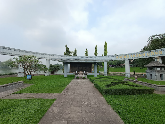
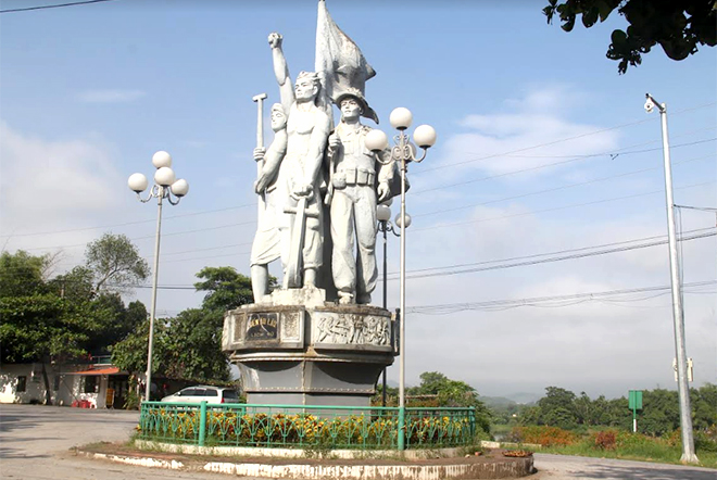
The grave site of Nguyen Thai Hoc and soldiers in the Yen Bai uprising in 1930, located in Yen Hoa park (30 hectares wide), Nguyen Thai Hoc ward, Yen Bai city, built in 2001 . Nguyen Thai Hoc was born on December 1, 1902 in Tho Tang, Vinh Tuong district, Vinh Phuc province. He was a patriot right from the time he was in a colonial school. He sent a letter to Governor General of Indochina Alexandre Varenne, a member of the French Socialist Party, calling for social reform in Vietnam. The Governor-General of Indochina did not pay attention to what Nguyen Thai Hoc suggested. On December 25, 1927, Nguyen Thai Hoc and his colleagues organized the establishment of the Vietnam Nationalist Party, and he was elected Chairman. The Vietnamese Nationalist Party was hunted down and arrested by the authorities. Faced with the risk of the Vietnamese Nationalist Party being broken up, Nguyen Thai Hoc, Nguyen Khac Nhu and Pho Duc Chinh decided to carry out a "general armed uprising". If you fail, it is also an example for the next generation to follow, "If you don't succeed, you will become a good person". The uprising force consisted of the Vietnam Nationalist Party, mainly red loincloth soldiers belonging to Companies 5, 6, 7, Battalion 2, 4th Tonkin Red Loincloth Soldier Regiment. Green loincloth soldiers did not participate in the uprising. On the night of February 9 to 10, 1930, the Yen Bai uprising broke out. The insurgent army killed most of the officers and non-commissioned officers in private houses, coordinating with the two-armed insurgent army and soldiers in the red loincloth station. 5 and 6 posts under rebellion. In front of the barracks yard, a representative of the Vietnam Nationalist Party read the article "Hit Uprising" with the slogans: "Drive the French enemy back to France. Bring the South back to the South. Let hundreds of them avoid suffering. More happy part". The flag of the Vietnam Nationalist Party flies above military camps and offices. Due to not being able to attract all the green loincloth soldiers No. 7 and No. 8 on the high station, the force was thin, so the insurgents were knocked out of their occupied positions, and the uprising was drowned in a sea of blood. Five days after the Yen Bai uprising, Nguyen Thai Hoc organized an uprising in Vinh Bao and Phu Duc, advocating to take over all of Hai Phong. The insurgents captured the district capital of Vinh Bao and killed district governor Hoang Gia Mo, a cruel and greedy mandarin. With a fierce counterattack by the French army with modern weapons, the insurgent army was destroyed. Nguyen Thai Hoc escaped due to the protection of the people. With a number of remaining prominent party members of the Vietnam Nationalist Party, Nguyen Thai Hoc discussed and planned to reform the Party and change the Party's strategic and operational direction. As soon as this policy was launched, on February 20, 1930, Nguyen Thai Hoc was arrested in Co Vit hamlet (Chi Linh, Hai Duong). On March 23, 1930, he was sentenced to death. On June 17, 1930, France sent Nguyen Thai Hoc and 12 other soldiers of the Vietnam Nationalist Party in Yen Bai to the guillotine. Stepping onto the scaffold, before putting his head into the guillotine, Nguyen Thai Hoc shouted: "Long live Vietnam!". France had to admit that the Yen Bai uprising had dealt a fatal blow to the colonial government. Nguyen Thai Hoc historical site marking the "Yen Bai Uprising" currently includes a mausoleum area, a monument area, a reception area, a memorial stele and a bonsai garden. Monument to Nguyen Thai Hoc and his associates during the Yen Bai uprising in 1930 at Yen Hoa Park, Yen Bai city. Most prominent in this area is the famous saying of Nguyen Thai Hoc, which became the main action motto and ideology of the Vietnam Nationalist Party, which is "If you are not successful, you will become a man", which was considered by the insurgents as a saying. swear to death. Although the Yen Bai uprising was not successful, patriotism is eternal. That's why, in our country, many places take the name Nguyen Thai Hoc to name avenues and schools. Mr. Phan Boi Chau wrote an oration about the Yen Bai uprising and the key figures of the uprising. Nguyen Thai Hoc historical relic site, Yen Bai city, Yen Bai province was recognized by the Ministry of Culture (now the Ministry of Culture, Sports and Tourism) as a national historical relic on March 5, 2019. 1990. Source: Yen Bai province electronic information portal
Yen Bai 2026 view
Au Lau Wharf (now located in Au Lau commune and Nguyen Phuc ward, Yen Bai city) is an important place to transport officers, soldiers, citizens, food and weapons to serve major campaigns. during the resistance war against the French colonialists, paving the way to the victory of the Dien Bien Phu campaign, restoring peace in the North in 1954. In 1953, the ferry wharf where people along the Red River traveled back and forth to exchange and trade was built into the Au Lau ferry wharf. Au Lau ferry terminal is a convenient connection point between Viet Bac and the Northwest of the country. From the early days of the resistance war against the French colonialists, Au Lau wharf was the place to gather and secretly transport revolutionary cadres and soldiers to prepare for the general uprising and then establish the Revolutionary Committee. temporarily and took over Yen Bai town. It was also here that the French colonialists escorted political prisoners from Nghe An (1943) and Thai Nguyen (1945) to prison at Cang Nghia Lo. On the night of August 16 and 17, 1945, according to the plan, the Au Lau Guerrilla Revolutionary Military Committee and the Au Co Guerrilla (Van Hoi) along with the soldiers on the right bank of the Red River crossed the river to attack the Security Camp to seize the government from their hands. Japan. In 1951, during the Ly Thuong Kiet campaign, one direction of the 312th Division crossed the wharf to attack Nghia Lo military zone (October 3, 1951). The Northwest Campaign took place on the night of October 10-11, 1952. Au Lau wharf was one of four wharves where the 36th regiment, 174th regiment of the 316th regiment and the 308th regiment crossed the Red River into Ca Vinh, Ba Khe, and Pass. Hong attacked Cua Nhi base. At the end of November 1952, according to the instructions of the Party Central Committee and the General Command, it was requested to urgently expand route 13 from Viet Bac through Yen Bai. Despite difficult circumstances and fierce enemy bombardment, we still opened the road 13 early 5 days through Au Lau wharf to provide reinforcements for the Northwest battlefield. Au Lau wharf has an important position connecting the Viet Bac transportation system with the Northwest, and is the only place where heavy weapons can be hoisted such as: ground artillery, anti-aircraft artillery, cars carrying ammunition. , military equipment crossed the river to reinforce the Dien Bien Phu battlefield. During this time, Au Lau wharf was reinforced in terms of both manpower and facilities to transport weapons, ammunition, food, foodstuffs, citizens, and soldiers across the Red River, and at the same time brace itself against the battles. fierce bombing by the French colonialists. At night is the time when most activities take place at Au Lau wharf to avoid enemy detection. Ferries travel back and forth as quickly as possible to clear the way for reinforcement vehicles. To prevent sabotage by enemy aircraft, during the day we had to drag the ferry upstream to Ngoi Lau to submerge the ferry, and at night we had to flood it again and pull it out. From November 1953 to May 1954, the French colonialists focused fierce bombardment on Au Lau wharf for more than 200 days and nights with 2,700 tons of bombs and ammunition, but we were only able to transport thousands of tons of food and goods for only 8 days and nights. hundreds of tons of ammunition and weapons for the Dien Bien Phu front. After serving the Dien Bien Phu campaign, from 1955-1965, the wharf was upgraded from a wooden ferry to a steel ferry with iron canoes. In 1965-1968, with the spirit: "Living by the bridge, dying courageously" the wharf 100 times brought 500 trucks across the river, transported nearly 200,000 cars, and thousands of tons of goods back and forth. During the years of fighting against the destructive war of the US imperialists, they used many groups of planes to attack for 4 hours, causing heavy damage to Yen Bai town and Au Lau ferry port on May 31, 1966. In 1967, Au Lau Wharf was honored to be visited by Prime Minister Pham Van Dong on the occasion of wishing New Year to the troops and people of Yen Bai and Nghia Lo provinces. On December 18, 1972, the American enemy continued to raid Yen Bai, including Au Lau wharf, but still could not stop ferries carrying people and food supplies to the southern battlefield. After the country was unified, Au Lau ferry continued to operate and became a key unit of the transportation industry in Yen Bai province. On August 7, 2012, Au Lau Wharf was recognized by the Ministry of Culture, Sports and Tourism as a national historical relic. Source: Yen Bai province electronic information portal
Yen Bai 1896 view
Yen Bai City Stadium Stadium, Hong Ha Ward, Yen Bai City is where Uncle Ho stood and talked to the people of Yen Bai province on September 25, 1958. This is a National Historical Site recognized by the Ministry of Culture and Information on November 16, 1988. The original ceremony is the grandstand of the old town stadium. The courtyard and ceremony platform are located in a densely populated area, the center of the former provincial capital. The town stadium dates back to the French colonial period. After completing the conquest and establishment of Yen Bai province (1900), in 1905, France established a legion camp to protect their government. To serve the spiritual life of soldiers, especially cultural and sports activities. In 1927, France built this stadium to organize festivals and football activities, but around the stadium were only built into high mounds without any stands, and it was not completed until 1930. Since then, France has regularly organized fun and entertainment activities here, invited football teams from Hanoi, Phu Tho, Tuyen Quang to compete, and also organized many days of "Western festivals" at the stands. this town stadium. In 1954, when peace was restored, Yen Bai province advocated restoring the football field into a town stadium. In January 1957, the province built a grandstand (the current grandstand) and a wall surrounding the field in an oval shape. The most important historical event was on September 25, 1958, the Government delegation led by President Ho Chi Minh visited Yen Bai province. During his time working in the province, at the request of President Ho Chi Minh, the Provincial Administrative Committee chose the town stadium as a meeting place for Uncle Ho to talk to people of all ethnic groups in the province. At that time, Yen Bai province was one of the most difficult provinces in the North, having just gained independence, the war was heavily destructive, most of the terrain was mountainous, sparsely populated, low educational level, and many victims. Nomadic farming, superstitions still abound, life is still extremely poor. During the most difficult time, Uncle Ho visited Yen Bai. Early in the morning of September 25, 1958, nearly 5,000 officials and people of Yen Bai town's ethnic groups and people from neighboring areas eagerly flocked to the rally to see Uncle Ho and hear his voice. Coming out of the provincial team, Uncle Ho went to the stadium and stepped onto the ceremony platform amid the thunderous cheers of his compatriots. After everyone was silent, Uncle Ho started talking. He cordially visited officials and people, pointing out practical actions. He mentioned many issues from national unity, increasing production, and practicing thrift. After talking, Uncle Ho joined the entire Yen Bai people in singing the song "Unite". From the platform, he left to return to work amid the applause and majestic songs of the people of the province. On May 31, 1966, a bombing by a US aircraft collapsed a corner of the stadium. In 1977, the stadium was repaired, replacing the arched door with a square door, the entire architecture remained the same. . In 2016, the Ceremonial Monument area was renovated and upgraded. The monument and the entire architecture of Uncle Ho's memorial area are designed in traditional architectural style, simulating the memorial architecture of Uncle Ho in Kim Lien - Nghe An, Uncle Ho's hometown. With that cultural and historical significance, this place is a destination, an address for people and tourists to visit and burn incense to commemorate Uncle Ho, forever a place to preserve sacred memories of the Leader. Great - President Ho Chi Minh in the hearts of the people of Yen Bai province, is a traditional educational address for young generations today and tomorrow. Source: Yen Bai province electronic information portal
Yen Bai 1877 view
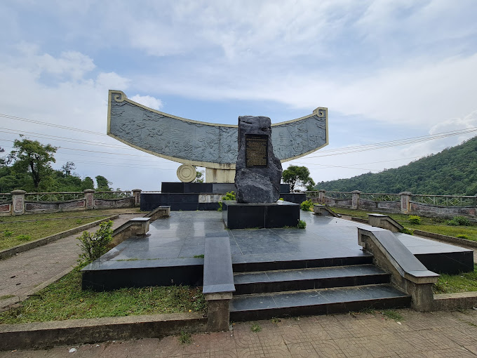
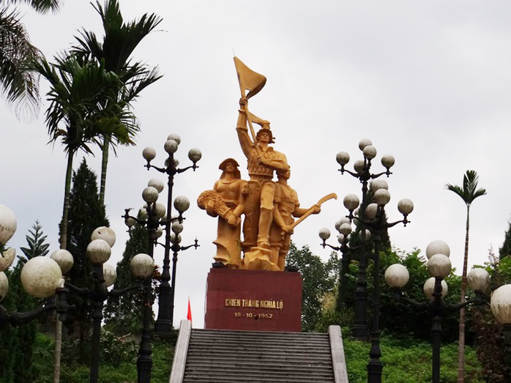
Khau Pha guerrilla team (Cao Pha commune, Mu Cang Chai district) was established in October 1946 at Trong Tong Khua village on the top of Khau Pha pass (previously it was an armed team established in 1944 by the Vietnamese people). Hmong people to fight against the oppression and exploitation of the rulers, then became the armed forces against the Nationalist Party). Initially, the force had only 7 members and only 3 self-made guns were weapons: flintlock guns, sharp knives and bows and crossbows. After a period of fighting, the guerrilla team grew very quickly in number, up to 30 people, 50 people and then at its largest number of more than 200 members, the participating forces were mostly local people (Hmong people). ). This is a relic located on a rugged mountainous area, stretching from the foot of Cao Pha pass to the top of the pass (over 20km long). The guerrilla team's area of operation is wide, with many locations, including the three most important locations, where important events took place during nearly 8 years of operation of the Khau Pha guerrilla team. They are: Tong Khua Drum Village - where the Khau Pha guerrilla team was founded;. Mr. Ly Nu Chu's house - the revolutionary base of the Khau Pha Guerrilla Team (Lim Mong village) and Bat Cave - the site of the French ambush at the foot of Khau Pha pass, in 1948. During the years of operation (1946 - 1952), the guerrilla team fought many battles, causing France many difficulties and losses. Established in 1946, the Team not only organizes training but also performs the duty of guarding and protecting the people and protecting production at the top of the pass while relying on the rugged mountain and forest terrain, coordinating with the main force and the army. The local team heroically fought the enemy, achieving many outstanding victories. On October 8, 1947, the enemy swept and attacked Khau Pha. Under the command of Captain Ly Nu Chu, the guerrilla team used a small force to fight back, killing a second officer and wounding many French soldiers, forcing the enemy to abandon the operation. During the period 1947-1949, the guerrilla team starved and thirsted many times, lived in the forest, ate brown tubers and grated tubers, determined to fight the enemy. During these arduous years, the Team achieved many remarkable achievements. Typically, in the battle of Nam Khat, a guerrilla team ambushed, shot and ran away an enemy company, capturing 2 guns. Next, in two consecutive battles in Gia Hoi and Tu Le, the guerrilla team coordinated with the army to chase the enemy, capturing 2 guns, many mines and grenades. In March 1948, the guerrilla team coordinated with the Quyet Tien Assault Team led by comrades Hong Quan and Ly Bach Luan to organize an ambush to attack the enemy on the Tu Le - Gia Hoi road, capturing 3 rifles. and some ammunition. At the end of March 1948, the Inter-Zone Party Committee and the Inter-Zone Command 10 decided to open the Nghia Lo campaign, with the Khau Pha guerrilla team coordinating with Company 520 and the Quyet Tien assault team to attack Tu Le post and capture them alive. named Bang Colonel Lo Van Inh (commander of the station), and at the same time disbanded a unit of 27 soldiers, confiscating 2 machine guns, nearly 20 rifles and a number of other weapons. After this victory, the team was equipped with 50 more guns. Since 1949, realizing the effectiveness of the Khau Pha Guerrilla Team, the enemy became more and more terrorist, they tried to concentrate the population and strictly control the terrain. Therefore, the team's activities encountered many difficulties: lack of food, ammunition, complete loss of contact with the Party, the government, and the army, but still remained absolutely loyal, persistent, and fought continuously. custom. After 1951, France fiercely attacked our facilities in the enemy's rear area, most of them were disintegrated. But with courage and tenacity to hold on, the Khau Pha Guerrilla Team still maintained the fight, causing many losses to the enemy. The team has become an important connection point located at Mu Cang Chai gateway, connecting revolutionary bases in the region with the two ends of Nghia Lo - Than Uyen. In October 1952, the General Command launched the Northwest campaign to liberate Nghia Lo Subdivision and the subregions of Than Uyen, Phu Yen, and Son La. On October 16, 1952, the enemy parachuted a battalion into Tu Le, Cao Pha, but it was destroyed and pursued by a guerrilla team coordinating with the main army. On October 15, 1952, Than Uyen was liberated. On October 18, 1952, the enemy failed miserably in Nghia Lo Subdivision and found a way to flee to Son La. The remnants of the enemy army passing through Cao Pha were pursued and destroyed by guerrilla forces. Mu Cang Chai was completely liberated from French colonial occupation. On August 27, 2012, the place where the Khau Pha guerrilla team was founded was recognized by the Ministry of Culture, Sports and Tourism as a national historical site. Source: Yen Bai province electronic information portal
Yen Bai 1866 view
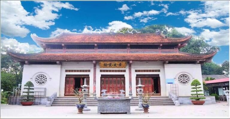
Dong Cuong Temple is one of two large temples in the upper reaches of the Red River, which has existed for a long time, located in Dong Cuong commune, Van Yen district, Yen Bai province. Dong Cuong Temple is a relic cluster consisting of 4 points: In addition to the main Temple, there are also Co Temple, Cau Temple and Duc Ong Temple. The temple has been around for a long time. Through historical records, it is known that the temple was built at the latest in the Le dynasty, developed from an ancient temple (in the center of Quy Hoa camp during the Tran dynasty); Ancient bibliographies such as Kien Van Tieu Luc and Dai Nam Thong Nhat Chi all have records about this Dong Cuong Temple. The temple and temple area are related to Ngoc Thap Temple and Hung Temple (Phu Tho). Dong Cuong Temple was initially a temple to worship Princess Dong Quang, founded by the Ha and Hoang families, who were Tay Khao people, and took turns in charge of government duties, and was also the workplace of Tho Tu, translators, and mandarins. and functioned as "Dinh Tram" to serve two-way dispatches between the central court and the grassroots. During the Tran dynasty, the general headquarters of Quy Hoa - Ha Bong and Mr. Tu (Ngoc Thap - Quang Son) came to guard the border. Currently, formerly the Dinh, now the Ha family temple is run by the Ha family's ancestor, Ha Van, who once led the locality to fight the Nguyen - Mongol invaders during the Tran dynasty. History records that in the second month of Dinh Hoi year (1287), the Nguyen - Mongol king took 70,000 troops, 500 warships, 6,000 Yunnan troops and 10,000 5,000 troops in 4 continents outside the sea and sent crown prince Thoat Hoan to be the great marshal; A Bat Xich became the Left Vehicle; Ah Lo Xich pacified political affairs; O Ma Nhi, in charge of politics, brought more than 300,000 troops to attack the South. Faced with that situation, Emperor Tran Thanh Tong and King Tran Nhan Tong ordained Hung Dao Vuong Tran Quoc Tuan as a moderator to command the entire Dai Viet army and people in the resistance war against the Yuan-Mongol invaders. The Yuan - Mongol army led by Nat Toc La Dinh ran up the Lo River to Van Nam. When running through Phu Ninh territory (now Phong Chau district, Phu Tho province), they were attacked by local soldiers and people led by the Ha Dac brothers, Ha Chuong withdrew his troops to attack the base of Mount Chi (in Phu Tho province). From the mountain, he sent militiamen to storm the enemy's vanguard station, launching a surprise attack with many military strategies. Ha Dac and Ha Chuong's troops chased the enemy all the way to A La, then were blocked by the enemy's rear army. Ha Dac heroically sacrificed his life, and Ha Chuong was captured. The Yuan - Mongol army was broken and suffered heavy losses, the survivors fled to Yunnan. According to the genealogy of the Ha family, "the Tay Khao people originally belonged to the Ha Dac and Ha Chuong lineages during the Tran dynasty. Now residing in An Boi - Kien Xuong, Thai Binh: Ha Dac and Ha Chuong are two brothers. When fighting the enemy, Ha Chuong enthusiastically pursued the enemy to the Yen Bai area and died there. He was awarded the title "Binh Nguyen Thuong General Trung Dung Marquis". (According to Tran Hung Hoa's fairy tale section) after being killed in battle and the villagers built a shrine next to the throne rapid (in Ghenh Ngai village on the left bank of Tan commune). Hop, Van Yen district), his wife Le Thi and his son Hoang Bao, when they died, were also worshiped by the villagers at Ghenh Ngai and shortly after, the mother and child altar was moved to Dong Cuong communal house (where the temple is located). Dong Cuong today). The second victory over the Yuan-Mongol army was a glorious victory. The typical places of Ham Tu, Chuong Duong, Tay Ket, and Cu Da will forever be recorded in history books. Since the relocation, the communal house was expanded and converted to become the Temple of Mr. Le Quy Don in the Later Le Dynasty, which has records. The book "Dai Nam Nhat Thong Chi" is named "Temple of the Guardian God" after the ordination. The events of the Giap Dan uprising (1913-1914), in 1914, the insurgents of Man Bach, Man Dai Ban and the Tay and Nung people of Yen Bai province organized to gather forces and rose up in the year of Giap Dan to attack the army's posts. France in Yen Bai and Lao Cai provinces. At the same time, overseas Viet Kieu railway workers and businessmen in Yunnan province - China responded to the call of Phan Boi Chau and other Vietnamese people to celebrate and establish friendship and patriotic associations overseas. , secretly supported the anti-French movement in the country. Some French military posts along the Vietnam-China border and Lao Cai area were attacked by insurgents. The uprising failed. Due to lack of proper organization. The French ruling government established a special military court during the war... to try patriotic soldiers, most were sentenced to death, life in prison or forced exile, some were secretly executed. sneaky. In 2000, the temple was recognized by the People's Committee of Yen Bai province as a provincial-level historical and cultural relic. On January 22, 2009, the temple was recognized by the Ministry of Culture, Sports and Tourism as a national historical-cultural relic in Decision No. 296/QD-BVHTTDL. Source: Yen Bai Provincial Museum
Yen Bai 1807 view
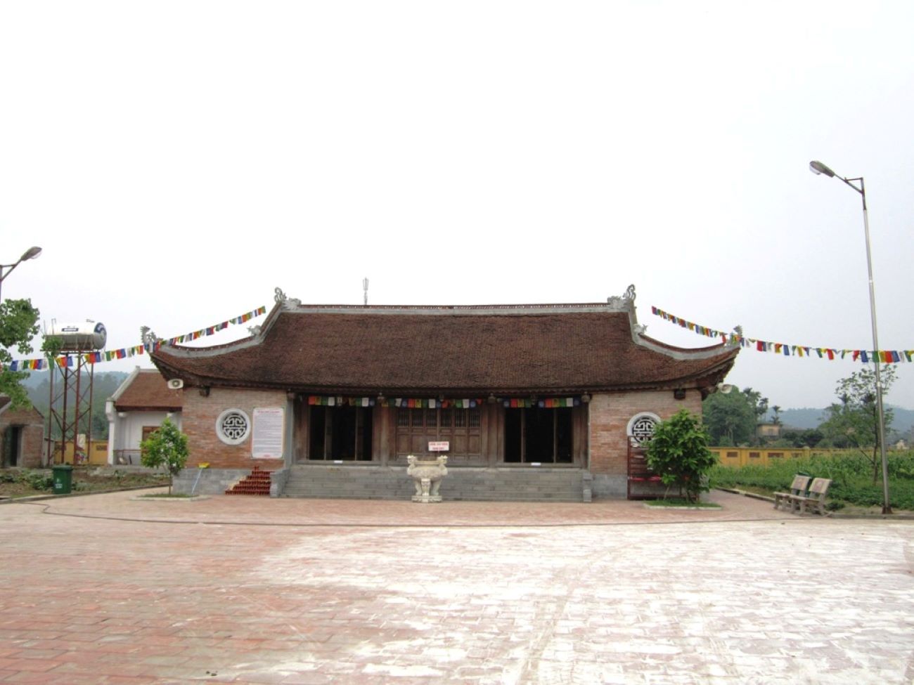
Nghia Lo Cang and Fort relic area is located on the main road of Dien Bien road (National Highway 32). This is the center point of Nghia Lo town and the Muong Lo field basin. When mentioning the history of Cang and Nghia Lo Fort, we refer to the place Van Chan and the history of this place during the resistance war against the French in the 40s of the twentieth century. With the intention of extinguishing our revolutionary movement, the French colonialists set up "special labor" camps to capture patriots and put them in concentration camps. After Cang Ba Van (Thai Nguyen) was dissolved, the French colonialists brought imprisoned patriots to Nghia Lo. In the summer of 1944, governor Van Chan mobilized the governors and communes to arrest husbands and submit materials to build the Cang. The French colonialists also sent Dinh Van Dung and Lam - Be from the district secret police department to urgently inspect day and night. By January 1945, construction was completed. Looking at the overall scene at this time, Nghia Lo Cang looks like a vertical cabinet with three long rows of houses. "Two rows are where political prisoners are detained for men, the inside is where political prisoners are detained for women, the outside is a permanent place and the outside is a place to detain political prisoners. Next to it is the guard station of green loincloth soldiers. Surrounding the entire Cang - Don area is a barbed wire fence, outside the fence is a deep tunnel with spikes, the Cang corner tank has a towering hut, carefully guarded day and night. The fierce fighting of our army and people with the incident of destroying Cang - Nghia Lo Fort, liberating Van Chan for the first time in 1945, are truly extremely heroic pages in history. Van Chan is a large district, located in the west of Yen Bai province, the terrain is a mountainous and forested area, with many high mountains and caves, and is a strategically important military position. retreat and take a defensive position". Therefore, the French enemy set a goal to conquer Van Chan. To carry out that intention, on October 2, 1947, they led troops to retake Van Chan, with the intention of attacking quickly and using strong military force and advanced weapons. The French colonialists wanted to subjugate the people of the Van Chan ethnic groups by shooting and killing in an extremely barbaric manner. Capturing Van Chan, the enemy relied on his henchmen to establish a governing apparatus from district to commune; At the same time, Nghia Lo station was established as the strongest military subdivision among the four subdivisions in the Northwest region of Vietnam. After setting up posts and setting up a governing apparatus, the French enemy carried out a plot to divide and rule, using people from one ethnic group to kill people from another ethnic group, using war to feed war; They turned the puppet army and puppet government system into a tool to oppress and exploit people of all ethnicities. They beheaded, disemboweled, and gutted some of our officers and soldiers. Then they used the stone mound on Ngoi Lao as an execution ground to execute 76 officers and soldiers in the middle of the rushing water. During nearly 5 years (1947 - 1952) of occupying Van Chan, the French killed and injured more than 300 people, leaving about 56 people missing. Thousands of children from all ethnic groups were forced to work as mercenaries for them, holding guns to shoot back at their compatriots and burning down their homeland's forests and mountains. In addition to shooting and killing, they also burned houses, destroyed rice, stole cattle and thousands of tons of food, and raped women and children. They forced the people to live right at the foot of the post to cut off contact with the Viet Minh and get them used to barbaric shooting and killing. Even more cruel, they also made fences with the bones and flesh of their compatriots to block the attacks of our troops. Small things like potatoes, cassava roots, rice bowls, rice bowls, and the most precious human things, the soul and body, are all snatched away by them and belong to the police station. Faced with the carnage of guns and bullets, the people of the Van Chan ethnic groups aroused deep resentment against the enemy, arousing faith, affection and patriotism, believing in the Viet Minh, believing in the resistance. Our people rose up with the spirit of determination to fight, determination to win and achieved victory at 5:30 a.m. on October 18, 1952. It was the support of our compatriots and the determination to win independence and freedom for the Fatherland that urged our army and people to fight, achieving a resounding victory in the fall of 1952, liberating Nghia Lo. To commemorate the heroic battles, on July 25, 1992, the People's Committee of Van Chan district built "Nghia Lo Cang Memorial". Currently, the Nghia Lo Cang - Fort relic area includes: Nghia Lo Cang Monument, Nghia Lo Victory Monument bearing the image of Uncle Ho's soldiers and people of all ethnic groups in the campaign to liberate Nghia Lo in October. in 1952, along with the stele inscribed with the names of martyrs. On September 27, 1996, the Minister of Culture and Information recognized Nghia Lo Cang and Fort relics as a National Historical Relic Area. Source: Yen Bai province electronic information portal
Yen Bai 1805 view
Van war zone is a fairly large area of land, located in the south of Tran Yen district and southeast of Van Chan district. Before 1945, Van War Zone was located in the areas of 3 cantons: Luong Ca, Gioi Phien (Tran Yen) and Dai Lich, Van Chan with a distance of 23km from North to South and 18km from East to West. The history of the war zone has undergone many changes over time, the place names and boundaries have changed. Previously this land belonged to Van Chan district, now belongs to Tran Yen district. In 1945, today's Van Hoi commune was called Minh Phu commune; On January 6, 1946, the Minh Phu - Dong Phu - Phu Thinh - Phu Luong commune was called Viet Cuong commune; On March 23, 1949, Viet Cuong commune was divided into two communes: Hong Duc and Viet Cuong; On January 1, 1951, 3 communes Viet Cuong, Hong Duc, Minh Quan were merged to be called Viet Hong commune; On January 4, 1954, Viet Cuong commune was divided into 3 communes: Viet Hong, Viet Cuong and Minh Quan; On June 6, 1988, the Council of Ministers divided Viet Hong commune into two communes: Viet Hong commune and Van Hoi commune. The boundaries may change, but the center of the War Zone is Minh Phu commune (Luong Ca district, Tran Yen district) which now includes 3 communes Viet Hong, Viet Cuong, Van Hoi, of which the typical 2 points are Lang Van, Viet Hong commune ( is the command center of the War Zone) and Dong Yen Village (in Van Hoi commune) is the military training center of the revolutionary base of the War Zone. Van Village: A valley surrounded by mountains with an average height of 200 to 500m, the valley is 4.5 km long, the road is difficult to travel, today it is structured by terraced fields. , after the revolution, it was explored by the people (with low variation) and is now called Dong Tro, Dong Cay Gao... with a Van stream running along the village. This is also the confluence of 3 small streams to create the Rhyme stream. The terrain is difficult, in the past there was only one road to the village and had to go through the pass. Both discreet and close to political centers (provincial capitals of Yen Bai and Phu Tho provinces), this area was chosen by the Northern Party Committee as a favorable place for establishing revolutionary bases that gradually developed and formed a model. War Zone style. Dong Yen village: About 4 km east of Van village and more than 3 km west of Hien Luong, is a village located between Van and Hien Luong. With a favorable location and raspberry-shaped hills, Dong Yen was chosen by the Au Co guerrilla team as a military training center to develop the armed forces to prepare for a general uprising to seize revolutionary power in Yen Bai. and Phu Tho. After assessing the geographical situation and people's spirit. Under the direct leadership of the Northern Party Committee, when establishing the Au Co guerrilla team, they moved to Dong Yen and then to Van village. Using Van as the command center, using Dong Yen as the military training center to form the War Zone. An important event took place here, on June 30, 1945, the Phu - Yen Inter-Provincial Affairs Committee (Phu Tho - Yen Bai) was established - an important historical milestone marking the formation of the War Zone. . The Van war zone relic is a milestone of historical events in Yen Bai in particular and of the vast Northwest region in general. The Van War Zone played a decisive role in preparing forces to fight for revolutionary power in the two provinces of Phu Tho - Yen Bai and Phu Yen district (Son La) and was also a base to ensure the locality in the war. preparation for the fierce resistance war against the French (1946 - 1954), where the inter-provincial Party Committee of Yen Bai - Phu Tho was established and was the forerunner of the Party Committees of the two provinces. On September 4, 1995, the Ministry of Culture and Information (now the Ministry of Culture, Sports and Tourism) recognized the Van War Zone as a National Historical Site. Source: Yen Bai province electronic information portal
Yen Bai 1749 view
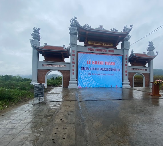
Located on the banks of the Red River, about 41 km from Mau A town, Van Yen district (Yen Bai) along provincial road 151 to the Nhuoc Son Temple Historical - Cultural Relic Area. This relic area in Ngoc Chau village, Chau Que Ha commune, is the temple to worship general Ha Chuong - a real figure in history, a talented martial general during the Tran Dynasty - who made great contributions to the defense and control of the war. kept the northern border area, contributing to our nation's glorious victory over the Yuan Mongol invaders. The relic site was classified as a national historical-cultural relic on November 16, 2005. Every year, on January 20 and September 20 (lunar calendar), local people eagerly prepare to welcome tourists from all over. Recently, not only local people, in the district, in the province but also many tourists from Hanoi and other provinces come to the temple. In the past two years, Nhuoc Son temple restored its festival activities and attracted more and more tourists from all over. Local people call Nhuoc Son temple by another name: Loong Meac, At Meac. According to "Records of Nhuoc Son Temple Relics" (Hoang Tien Long, Yen Bai Provincial Museum), in February of the year Dinh Hoi 1287, more than 300,000 Yuan Mongol troops attacked our country, the Yuan Mongol army led by Nat Toc Lat Dinh When the commander fled through Phu Ninh area, he was blocked and attacked by the local army and people led by brothers Ha Dac and Ha Chuong. When chasing the enemy to A La, the brothers Ha Dac and Ha Chuong were blocked by the enemy's rear army, Ha Dac heroically sacrificed his life, and Ha Chuong was captured. Taking advantage of the dark night and the enemy's loopholes, Ha Chuong took the enemy's flag and uniform to escape, asking the court to use the flag and uniform to pretend to be the enemy's soldiers at their camp. When the enemy was suddenly attacked, they were unable to take precautions and were attacked from the inside by Ha Chuong's army. The Mongol Yuan army was broken and withdrew its remaining troops to Yunnan. According to the genealogy of the Ha family, they were originally Tay Khao people, belonged to the Ha Dac and Ha Chuong lineages during the Tran dynasty, now residing in An Boi, Kien Xuong district, Thai Binh province. When fighting the Yuan army, Ha Chuong enthusiastically pursued the enemy. went to Yen Bai area and sacrificed. According to the elders in Chau Que Ha commune, Ha Chuong, during the second resistance war against the Mongol Yuan army, chased the Yuan army along the Red River to Yen Bai, arriving at present-day Chau Que Ha to recruit more soldiers to continue the pursuit. attack and destroy the enemy army. During the decisive battle, Ha Chuong was seriously injured, sacrificed and was taken to the river to be buried at the mouth of Nhuoc Son waterfall.... Source: Yen Bai province electronic information portal
Yen Bai 1707 view
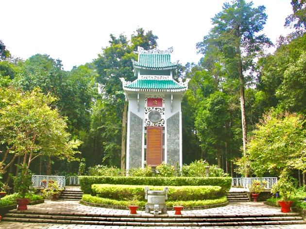
Location of the Northwest Party Committee is in Chanh village, Phu Nham commune, Van Chan district, Yen Bai province, 12km east of Van Chan district capital, 80km northeast of Yen Bai city. The headquarters of the Northwest Regional Party Committee from November 1953 to the end of 1954 was Chanh village, Phu Nham commune, Van Chan district. Previously, Chanh village was called Chanh Quan village, but due to the increasing population density, Chanh Quan village was split into two villages: Quan village and Chanh village. In the 19th century, around 1873, when the Yellow Flag invaders (remnants of the Thai Binh Thien Quoc - China peasant uprising movement) were attacked by Doi Tai (according to Thai reading, the official name is recorded in history books). Diep Tai) led the army to invade Muong Lo land, Phu Nham people heroically stood up at the call of the Thai leader Cam Ngoc Hanh against the Yellow Flag invaders. In 1875 - 1896, in response to King Ham Nghi's Can Vuong decree, the anti-French colonial movement led by Nguyen Quang Bich developed rapidly. In Yen Bai, operational centers of the insurgents were formed in the Dai Lich and Muong Lo basin areas... during that time, people of all ethnic groups in the above locations were united with the insurgents. against the invaders and the people of Phu Nham commune also enthusiastically participated in those activities. To prepare to liberate the Northwest region from French colonial occupation, in May 1952 the Party Central Committee and President Ho Chi Minh decided that the four provinces of Yen Bai, Lao Cai, Lai Chau and Son La separated from Viet Bac and Son La inter-regions. under the direct leadership and direction of Region XX (predecessor of the Northwest Region Party Committee). In mid-1953, the Central Committee mobilized Comrade Tran Quyet - Secretary of the Son La Provincial Party Committee to add to the Regional Party Committee, the Northwest region police director, Mr. Lo Van Muoi - Member of the Son La Provincial Resistance Administrative Committee to take over. work in the District. In May 1952, the headquarters of zone XX was located in Dong Ly village, Yen Binh district, Tuyen Quang province (now Yen Bai province). On October 14, 1952, the Northwest campaign began. In just ten days, we liberated a large area on the left bank of the Da River, including the districts of Van Chan, Than Uyen (Yen Bai), Phu Yen and one district. Quynh Nhai district (Son La); After that, our troops launched the second phase of the Northwest campaign, by the end of December 1952, liberating most of the Northwest (except for Na San base and Lai Chau town). To deepen the leadership, in November 1952, zone XX moved its headquarters to Hung Khanh commune, Tran Yen district, Yen Bai province (Thac Thien - km 28, road 13A). In early 1953, we opened road 13A from Ba Khe to connect with road 41 (Hanoi to Son La - Lai Chau) in Co Noi to prepare forces to attack the Na San stronghold group. Seeing the risk of being attacked, the French enemy secretly withdrew their Na San base (May 1953) to preserve their forces. In November 1953, the Northwest Party Committee transferred all agencies of the Party Committee to scattered locations in the villages of Phu Nham commune, Van Chan district. Up to now, due to the new demands of the revolution and the country, although the Northwest Party Committee no longer exists, the site of Chanh village, Phu Nham commune - where the Party Committee chose to have its headquarters and work, led the movement. The revolution of the four Northwest provinces has become a place deeply engraved in the minds and emotions of generations of officials and people who directly participated in activities and served the resistance. On August 27, 2012, the Ministry of Culture, Sports and Tourism recognized the site of the Northwest Party Committee, Phu Nham commune, Van Chan district as a national relic. Source: Yen Bai province electronic information portal
Yen Bai 1652 view
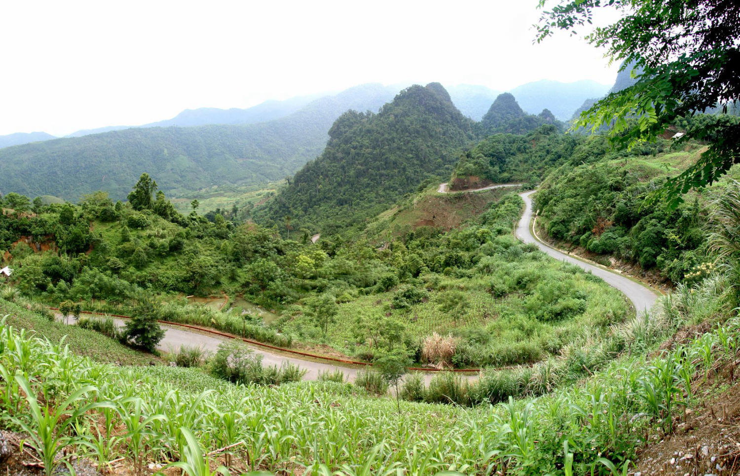
Lung Lo Pass belongs to Da village, Thuong Bang La commune, Van Chan district, Yen Bai province, the pass is also known as Dao Pass. Lung Lo - a place that has entered the history books during the nation's heroic resistance war against the French as a legend. Here, the army and people of the whole country devoted their efforts to supplying supplies to the Dien Bien Phu battlefield through Lung Lo pass. Lung Lo Pass is located on National Highway 37 (old Road 379, connecting National Highway 32 with National Highway 32B) at the border of Van Chan (Yen Bai) and Phu Yen (Son La) districts, located northeast and far from town. Phu Yen33 km. The pass is 15 km long, from km 349 to km 364, with a slope of 10%. During the resistance war against the French colonialists, the Party Central Committee decided to open road 13A starting from Ben Hien, Tuyen Quang province, passing Ben Au Lau, passing Lung Lo pass to Co Noi intersection, connecting with road 41 Phuc service for the Dien Bien Phu campaign. The route that the engineers and civil workers had to open was over 120km long, the terrain was mainly high mountains and deep abysses, and had to pass through three large rivers: the Chay River, the Red River and the Da River. Clearly defining the political task of ensuring smooth traffic flow to the battlefield, as early as April 1953, at the request of the General Staff, Yen Bai province decided to establish route 13, mobilize 124,458 people participated in paving the road with 173,197 people digging, filling and leveling bomb craters to prevent landslides. Local people voluntarily donated thousands of trees, tens of thousands of bamboo trees, bamboo trees, bamboo poles, and house pillars to line roads, build bridges to open traffic, and transport military food into the campaign. After more than 200 days and nights, our army and people paved the way, protected and transported thousands of tons of food, military equipment, weapons and ammunition to safety. The route through Lung Lo Pass was smoothly connected to the Viet Bac war zone and the Northwest provinces, serving the Dien Bien Phu campaign, thanks to which tens of thousands of cars and carts carrying weapons and goods provided timely and adequate support to the soldiers. battlefield. Faced with that situation, in February 1954, the French colonialists concentrated their air force on fierce attacks on the roads to the Northwest, in order to prevent reinforcements from the rear to the battlefield. Along with Au Lau, Hung Khanh, Vuc Tuan, and Co Noi, the Lung Lo pass location is where the enemy dropped nearly 12,000 tons of bombs, some days the enemy dropped 200 bombs. During the campaign, 16 to 18 enemy planes bombed 5 to 6 times every day. Overcoming danger, despite falling bombs and explosions, with the spirit of all serving the front line, tens of thousands of people and citizens stuck to the road day and night. The enemy destroys, we correct ourselves, the enemy destroys this section, we open another section, the enemy destroys during the day, we open the way at night. Tens of thousands of tons of food, military equipment, weapons and ammunition, tens of thousands of tons of food and foodstuffs gathered in the Thuong Bang La area crossed the pass into the battlefield and were safely protected. With a heavy task and urgent time, the supply road to Dien Bien Phu through Lung Lo Pass was completed 10 days ahead of schedule and became a historical miracle, surprising and terrifying the French colonialists. brave spirit of our army and people. From the solidarity and unity in labor and fighting of officers, soldiers and people of all ethnic groups in Yen Bai province, Road 13A - a historical and cultural road was formed, making a positive contribution to the war. Dien Bien Phu victory and the process of socio-economic development of the two provinces of Yen Bai and Son La. Later the road was named "National Highway 13A" - historical road. Lung Lo Pass - a legendary road, was recognized and ranked as a national historical relic by the Ministry of Culture, Sports and Tourism in 2011, on the occasion of the 57th anniversary of the Dien Bien Phu Victory (May 7. 1954-May 7, 2011). Source: Yen Bai province electronic information portal
Yen Bai 1588 view


 vn
vn en
en ja
ja ko
ko zh
zh VIP member benefits