Explore the history, culture, people and beautiful landscapes of Vietnam on the 63Stravel travel app
Download the 63stravel app


Binh Phuoc 901 view

Download the 63Stravel app to immerse yourself in countless beautiful photos of Vietnam
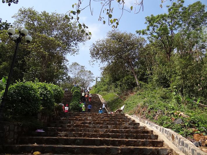
The way to the top of Ba Ra mountain
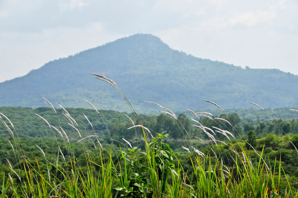
Ba Ra Mountain - The highest mountain in Binh Phuoc
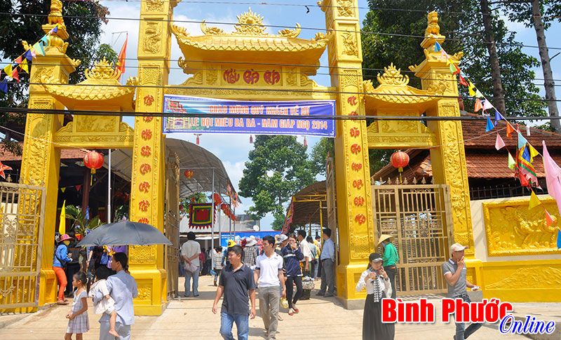
Temple area of Ba Ra mountain
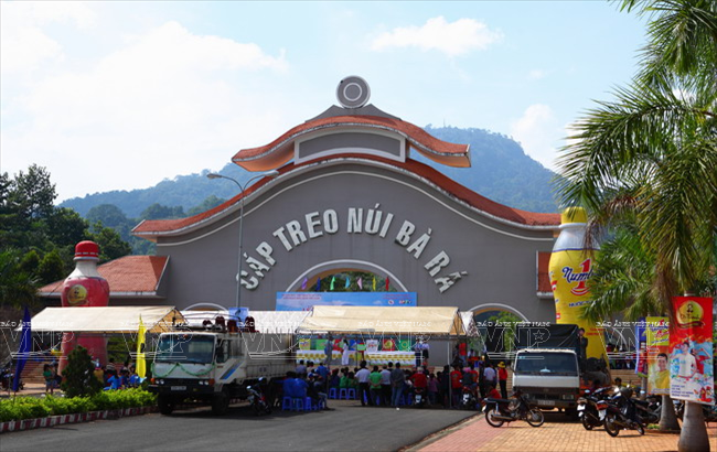
Ba Ra mountain cable car area

The beauty of Ba Ra mountain from afar


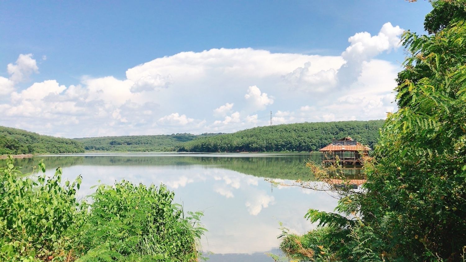
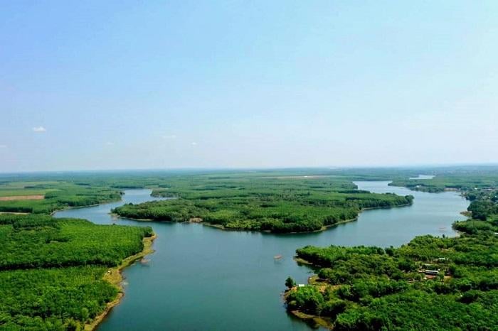
Suoi Lam Lake Tourist Area is one of the famous natural tourist destinations in Binh Phuoc next to Bu Gia Map National Park, Thac Mo Hydroelectric Lake, Ba Ra Mountain... With a romantic blue lake and forests. Rubber trees stretch to the horizon, the scenery here not only captures the hearts of the traveling community but also turns Suoi Lam Lake into the most popular weekend destination. It can be said that every season, this place captivates the footsteps of discoverers in a very unique way. If the period from December to January next year is memorable because of the cold weather and the radiant spring sunlight filtering through the leaves that are gradually changing color, then late February and early March will be the ideal time. Let you immerse yourself in the pure white color of the blooming coffee flower forest. Located in Dong Phu district, Binh Phuoc province, Ho Suoi Lam tourist area is very close to Ho Chi Minh City. With a distance of about 120km, it is extremely convenient for traveling, you can easily get here by many types of means of transport such as motorbikes, cars, and buses. A little more specifically about long-distance transportation, at Mien Dong Bus Station there are many bus routes departing from Saigon to Binh Phuoc. Depending on the bus company as well as the travel distance you choose, the expected ticket price will be around 65,000 VND to 100,000 VND/person. For backpackers who want to conquer Binh Phuoc in general and Ho Suoi Lam tourist area in particular by motorbike, below are the most popular routes from near and far: Starting from Saigon, you can go towards Binh Trieu Bridge to Highway 13 or Saigon Bridge to Hanoi Highway. No matter which route you choose, explorers will stop by Binh Duong - a place that welcomes you with a forest of rubber trees all along both sides of the road, as beautiful as a Korean movie, extremely suitable for check-in. virtual living". Possessing an area of up to 100 hectares, Suoi Lam Lake has a depth of about 4 meters. The lake surface here is calm all year round, making a special impression with its clear water reflecting the clouds. Surrounded by immense forests, the lake and stream are home to many species of freshwater fish such as silver carp and carp. carp, snakehead fish, carp... Not only does it impress with the pristine, peaceful and green natural scenery, coming here during the flower blooming season you also have the opportunity to enjoy the beautiful lake space like an earthly fairyland. The surface of the lake, which was originally like a shining mirror, is now covered with a layer of pure white flowers with extremely clear and pure beauty. Rowing a boat in the middle of the lake, you will soon let your soul drift along this beautiful forest of flowers and let them gently relieve all the pressure and fatigue that comes from a busy everyday life. Besides the captivating natural beauty, Suoi Lam Lake Tourist Area is also an ideal destination for relaxation, camping, fishing and picnics. Young people who come here after taking photos with the poetic lake and setting up tents to camp along the forest often participate in recreational activities such as bathing in streams, boating, water skiing... The tourist area also Providing large bamboo huts and cheap charcoal stove services to serve the picnic needs of families and groups of friends.
Binh Phuoc 1705 view
November to April
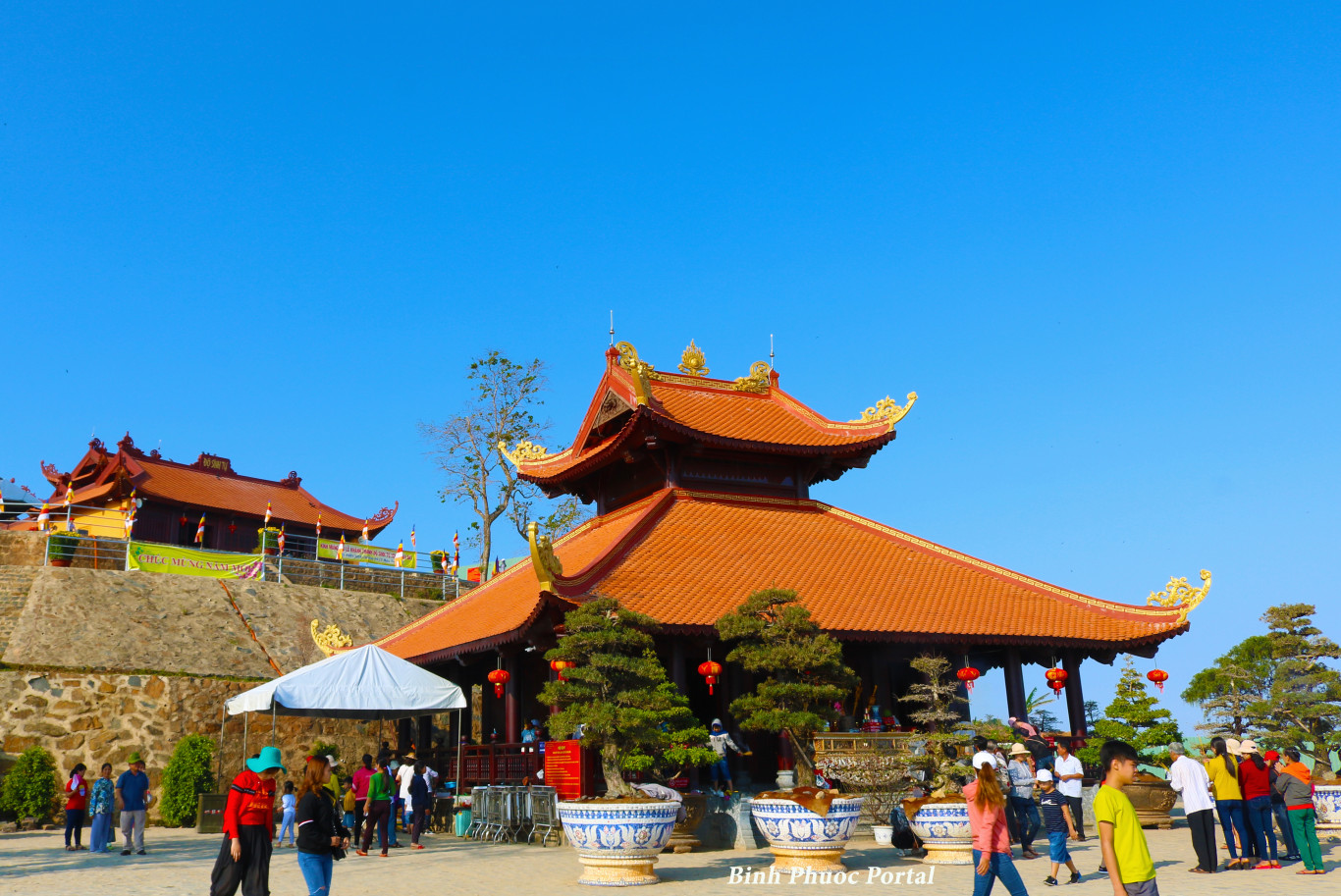
As one of the three highest mountains in the Southeast region, Ba Ra Thac Mo Mountain, Binh Phuoc, located at an altitude of 723m above sea level and with rugged terrain, was once a place marking many heroic, resilient and heroic achievements. There are so many anecdotes associated with important historical events of the nation. At Ba Ra Mountain Thac Mo Binh Phuoc also has Be River, Thac Me, Thac Mo hydroelectric power plant and forests with diverse and rich flora. Coming here, you will definitely admire the beautiful landscape painting that captivates people's hearts. From 1925 to 1941, the French colonialists built at the foot of Ba Ra mountain a large prison consisting of 3 military camps: Military camp A to imprison thieves and robbers; Military camp B held female prisoners, political criminals, and people suspected of being communists but not convicted; Military camp C to hold political prisoners. Currently, on the top of Ba Ra mountain there are still traces of the airport built by the American invaders. In addition, to commemorate the merits, a stele house and a memorial temple for soldiers, soldiers and people who sacrificed their lives in the resistance war in the Ba Ra area were built on Bang Lang hill in the Ba Ra mountain relic complex. Thac Mo Binh Phuoc. Another option for young people who like to explore and conquer spectacular challenges is trekking Ba Ra mountain. From the foot of the mountain, you can travel by motorbike or car along the paved road leading to Bang Lang hill. There is a memorial stele here to remember the merits of heroic martyrs. In addition, you can also try to experience the feeling of riding the cable car here. Ba Ra Temple is a project belonging to the Ba Ra historical relic complex and is also known as Linh Son Temple. The design here is inspired by the beliefs of the Southeast region, similar to famous architectural works in the Ba Den mountain complex (Tay Ninh) and Ba Chua Xu (An Giang). On the 1st, 2nd, 3rd, 4th days of the third lunar month every year, the Ba Ra Temple Festival is held, attracting many people to gather here to visit and express their gratitude and belief in their beliefs. folk. Binh Phuoc is not only famous for tourist destinations such as Bu Gia Map National Park or Quang Minh Pagoda. Ba Ra Mountain Thac Mo Binh Phuoc is also one of the tourist attractions that attracts many people from all provinces and cities to admire.
Binh Phuoc 1726 view
From January to December
If you are looking for a spacious and cool camping location near Saigon, please refer to Bu Lach Glade. Located in village 7, Dong Nai commune, Bu Dang district, Binh Phuoc, this is one of the most attractive camping locations for tourists. Surrounded by primeval forests and a large lake in the middle, Bu Lach has a strangely pristine and peaceful natural scenery. This place was originally a cluster of nearly 20 grasslands of different sizes with an area of up to 500 hectares. The reason for its name is due to a misreading of the local language of the M'Nong people. The village elders explained that here the word "lach" in the M'Nong language means "glad", in the glade there is a water tank so it is called Bau Lach, if read incorrectly it becomes Bu Lach. The road to Bu Lach Grassland is not too difficult. If you are from Saigon, you can buy bus tickets at Mien Dong bus station. Ticket prices are usually from 100k to 250k. If you want to explore nature and travel, you can travel by motorbike. There are two directions to get to Binh Phuoc. One is from Binh Trieu Bridge to follow Highway 133. The second direction is from Saigon Bridge to Hanoi Highway. Travel time is about 2 hours and 30 minutes to arrive. Check-in to the grassland, visitors will be amazed at what nature has bestowed upon them. These are vast green lawns surrounded by clear blue water, surrounded by primeval forests. Just like that, one glade follows another, endlessly green. The glades are usually about 5-10 hectares wide, but Big Glade is the most beautiful and widest, nearly 100 hectares. Another unique feature is that there is only one type of needle grass growing mixed with purple wildflowers, making the scene even more wild. Not only is the background beautiful for taking photos, you will also be impressed with the scenery here. Just standing there looking and breathing feels good. All the worries, fatigue, and dust have gone, leaving only the feeling of being surrounded by nature. Visitors here can also fish, walk sightseeing, boating, camping, play soccer on the grass, etc. Especially, in the dry season, the grass in the glade will turn bright yellow. You can bring tents to camp and hold BBQ parties. In addition to playing in the lake and grass fields, you can also go deep inside to see beautiful waterfalls. The grasslands and water basins are all protected forest areas and forbidden forests, so there are no residents living here. Around the grassland there are only villages of the S'tieng, M'Nong and Chau Ma ethnic groups. You can visit the communal houses to visit and learn about their culture. If you come in the third lunar month, you will be able to participate in their Dam Bau fish-catching festival.
Binh Phuoc 1947 view
From January to December
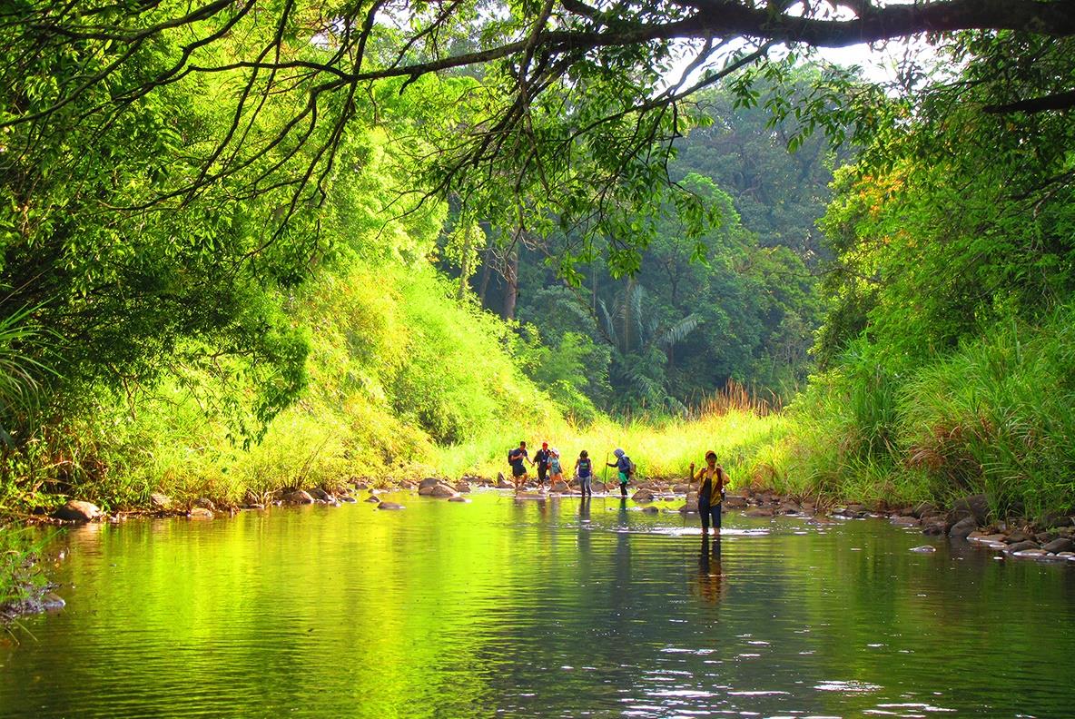
Known as one of the famous national parks in Vietnam thanks to its diverse natural ecosystem, flora and fauna that contribute to creating impressive scenery. Bu Gia Map National Park is currently a famous tourist attraction that many people choose to visit when coming to Bu Gia Map district, Binh Phuoc province. Although it has been established for many years, it was not until 2002 that this place was officially converted from a conservation area to a national park. With a total area of 25,601.18 hectares and divided into many conservation areas for many rare plants, directly affecting the genetic research process of many precious plant species. In particular, the forest coverage reaches 90%, creating a habitat for many types of animals. Not only does it play a conservation role, this is also a national park that greatly contributes to protecting and regulating water sources for hydroelectric and irrigation lakes. Visitors to Bu Gia Map National Park will be able to admire the close natural scenery, admire the green beauty, discover many precious flora and fauna species, and participate in interesting activities. Characterized by a sub-equatorial tropical monsoon climate, the national park has two distinct seasons: sunny and dry during the year. In particular, the average temperature will be about 25.8 - 26.2°C, which is quite favorable for visiting and exploring the national park landscape during the trip. Therefore, you can schedule a visit to the tourist area at any time of the year. However, to have a smooth visit and keep many memorable memories, you should choose to go during the dry season. Specifically, from November to early May of next year, you should avoid going to Bu Gia Map National Park during the rainy season because it will make it difficult to move and see the scenery. After arriving in Binh Phuoc province, to have a memorable and easier trip to Bu Gia Map National Park, many tourists are interested in choosing a quality place to stop. With the strong development of the tourism industry and the large number of tourists visiting every year, here you can find many hotels in Binh Phuoc. In particular, depending on the needs and desires of each person, they can choose a hotel with suitable quality for themselves. Therefore, you do not need to worry about where to stay on this tour. Besides, visitors can also refer to hotels in Binh Duong or City. Ho Chi Minh if you plan to visit during the day or camp on site. Trekking activities are indispensable when visiting natural tourist destinations such as national parks. During this process, you will experience many adventurous activities, immersing yourself in exciting space and scenery. At the same time, this is also an opportunity to explore many species of flora and fauna preserved in the national park. In addition, Da Voi Beach and Dak Mai Waterfall are an interesting attraction located in the national park area. Not only is it a large area, but this place also possesses many giant rocks in the middle of lush cashew gardens. and create the majestic Elephant Rock. Besides, Dak Mai waterfall flows from Dak Nong through Bu Gia Map national park combining changes in height to create an impressive and beautiful waterfall. One of the great experiences when coming to the famous tourist area in Binh Phuoc is to enjoy delicious dishes that are uniquely prepared and attractive. Some outstanding dishes that are highly appreciated by many tourists include: beef soup, bamboo-tube rice, wild boar meat, etc. All of them use available ingredients grown by local people. Through skillful processing, it creates unforgettable specialties from the first time you enjoy it.
Binh Phuoc 1823 view
November to early May
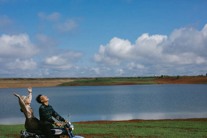
Suoi Giai Lake is a charming landscape located in Tan Lap commune, Dong Phu district. About 20 km from the center of Dong Xoai City, and about 80 km from the center of Ho Chi Minh City, Suoi Giai Lake is like a peaceful space nestled among the noise and dust of the city. The name Suoi Giai Lake comes from the connotation of Giai Nhan stream, which also means beautiful young woman. Therefore, the beautiful scenery here is often compared to a fairy descending to earth, gentle, gentle but no less flashy. Suoi Giai Lake is about 1.5 km wide, nestled between two hills, you can see the lake bed from above while driving. Review of Suoi Giai Lake shows that, in the past, Suoi Giai Lake was the upstream of a small stream. In 1978, after being approved by the Binh Phuoc provincial government, this place was converted into an irrigation dam with the task of storing and providing water for the use of the people here. Currently, this place is an interesting destination for the backpacking community, suitable for experiencing various types of activities such as camping, boating or fishing. Suoi Giai Lake is a large dam with a romantic and charming scene. At noon, the rays of sunlight shine down on the sparkling clear water, creating a very poetic and peaceful space. The most expensive scenery at Suoi Giai Lake must be at sunrise and sunset. When the sun appears and disappears, the scene seems to be dyed a brilliant orange-yellow color, lighting up the whole land and sky. On the lake bed, you can easily see the scene of a fisherman fishing and catching fish. It all took place under the sunset, painting a picture that couldn't have been more peaceful and romantic. Besides, when moving to Suoi Giai Lake, you will easily encounter wonderful and quite famous scenery. If you move from Binh Duong, you will pass by the Song Be Broken Bridge Relic, a famous place that appears quite a lot on the screen. In addition, when moving around the province, it will not be difficult for you to encounter Binh Phuoc rubber forests during the leaf-changing season. This is a place that many young people check in at the end of the year, when the forests are tall. The sun becomes bright yellow in a corner of Binh Phuoc sky.
Binh Phuoc 1658 view
November to April
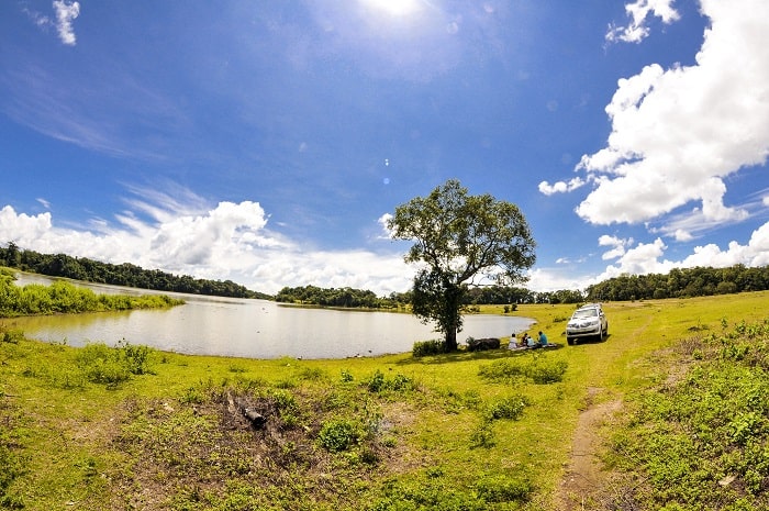
Thac Mo hydroelectric reservoir is located in two districts of Phuoc Long and Bu Dang of Binh Phuoc province. This is an artificial lake with an area of about 110km2 in the Thac Mo hydroelectric project complex. This place's main task is to provide water to surrounding areas as well as help Thac Mo hydroelectric plant produce electricity to serve people's daily activities. Besides, Thac Mo hydroelectric lake has a charming landscape with many cultivated plantations, green grasslands, open space and fresh air. This place is gradually becoming an attractive destination for young people who like to explore new and interesting things. Currently, Binh Phuoc province still does not have an airport, so if you are in the North and want to explore Thac Mo hydroelectric lake, you can move to Tan Son Nhat airport, Ho Chi Minh City. Then, from the airport continue to travel by bus from Ho Chi Minh City to Binh Phuoc to this attraction. With a distance of 154km, it will take you about 4 more hours to drive from the city center to Thac Mo hydropower plant. Don't be afraid of the long distance, the road to Thac Mo hydroelectric power plant will make you surprised by the beautiful and enchanting scenery. If you choose Ho Chi Minh City center as the starting point when traveling by motorbike, we will guide you on the route from Ben Thanh market to Thac Mo hydroelectric lake. From Nguyen Thi Minh Khai and Dien Bien Phu streets, you go straight to Xo Viet Nghe Tinh/National Highway 13 (5.3km). Then, go along Highway 13 to Go Dua Street in Thu Duc (7.8km). At the intersection between DT743 and DT745/DT747B, continue moving toward Nguyen Tat Thanh in Phuoc Long town (107km). Finally, after reaching Thac Me bridge at Duc Hanh (6.4km), run straight to reach Thac Mo hydroelectric power plant. Along the road to Ba Ra Mountain Thac Mo Binh Phuoc, you will admire many beautiful landscapes that cannot be found anywhere else. Here you can trek with friends and relatives to Ba Ra mountain. On the way, you will easily encounter perennial rubber forests planted in extremely poetic straight lines. If you are lucky enough to go here in the fall, this road will be tinged with a dreamy yellow color like a European scene. You can also see fruit orchards such as durian, rambutan, or vegetable plantations. If you want, you can visit, experience and pick vegetables and fruits at the garden to enjoy the fresh taste of newly picked fruits. Thac Mo Hydropower Plant is located at the foot of Ba Ra Mountain, as beautiful as a vast steppe. Because tourism has not been exploited much, the scenery here is still wild and has a poetic beauty. Try with the people to experience fishing right on the lake, vacation on a beautiful small island here or enjoy rustic grilled fish. On weekends, to avoid the hustle and bustle of the city, have a picnic with friends right at the Thac Mo hydropower grassland. The large, green lawn will be a place for you to release all daily fatigue and stress and immerse yourself in the open nature. Most especially, you will have the opportunity to enjoy fish dishes, eel from Be River accompanied by Ba Ra wild banana flowers and a few jars of wine by the red fire.
Binh Phuoc 1829 view
November to April
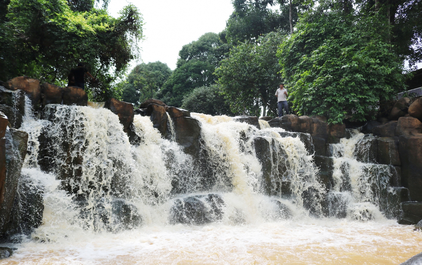
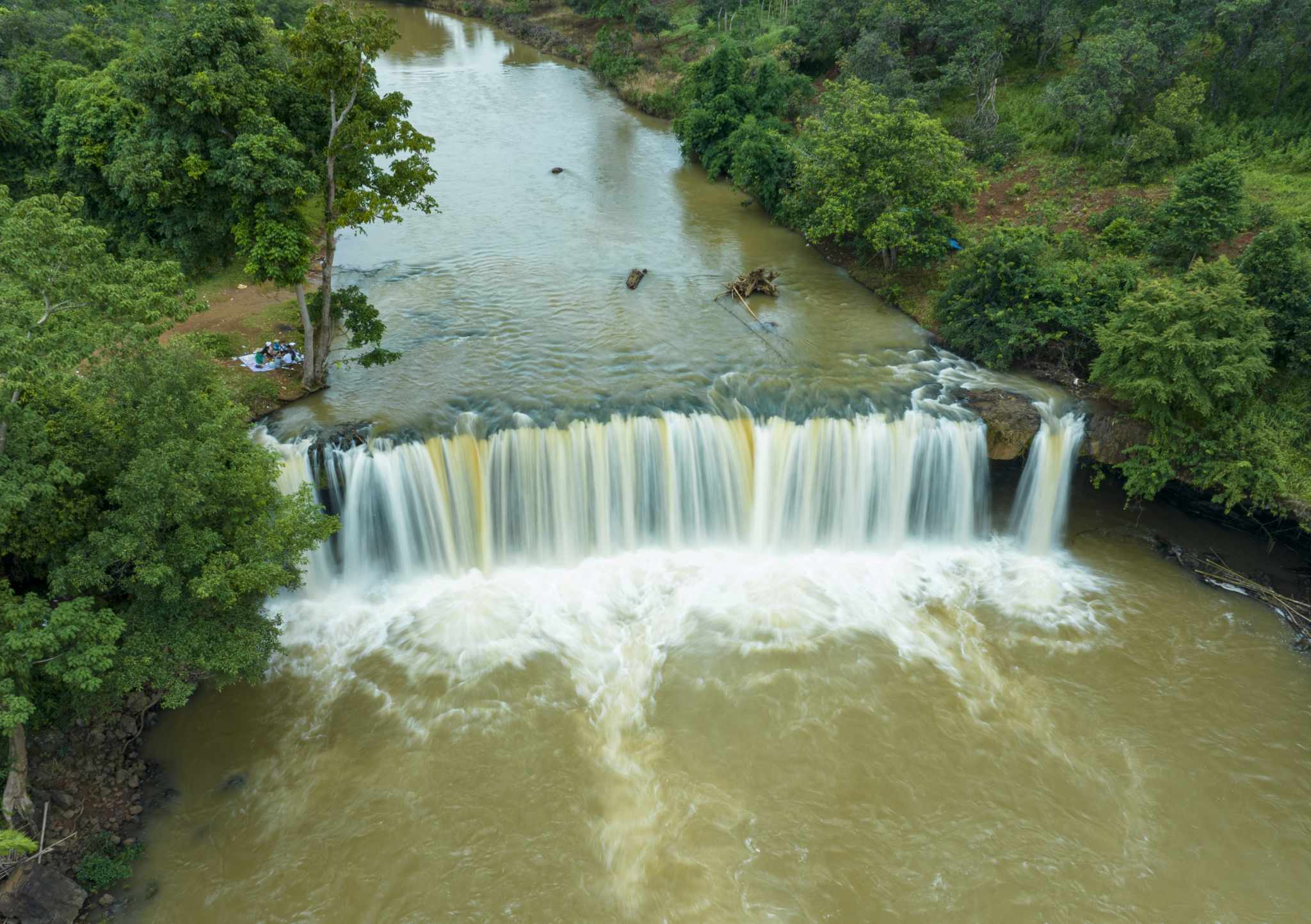
Standing Waterfall is originally a waterfall in the flow of Dak Quottle stream, in Bu Dang district, Binh Phuoc province. This is a waterfall connecting two hillsides in Minh Hung and Doan Ket communes, about 6km from Bu Dang district center, 55km from Dong Xoai city center, and about 23km from Bu Lach Grassland. With a geographical distance not too far, you can absolutely choose to visit Standing Waterfall if you have the opportunity to visit Dong Xoai city. The name Standing Waterfall comes from the difficult terrain of this waterfall. The scenery of the waterfall is the image of tall rocks stacked vertically on top of each other, so the waterfall is called Standing Waterfall. Depending on each climate type, Standing Waterfall will have its own unique beauty that nothing can mix with. Standing Waterfall in the rainy season, with strong streams of water due to the high flow of water, Standing Waterfall is like a wave rolling vertically, water pouring back into the lake surface, rushing hard against the rocks, releasing bubbles. White. The scenery at Standing Waterfall at this time looks splendid and easily makes people excited. However, because of the strong flow, the terrain of Standing Waterfall now becomes complex and winding, making it difficult to move. The waterfall water in the rainy season is also yellow in color because the soil here is mainly red basalt soil. Standing Waterfall in the dry season, this place seems to be nestled among the noise of the mountains and forests. No longer rolling waves churning out white foam, Standing Waterfall now gently nestles in the rocks, pouring out charming blue streams. This is also the best time that you should visit Standing Waterfall, floating and enjoying the cool sounds of nature. The notable highlight of the waterfall is the tall rocks stacked on top of each other amidst the vast mountains and forests, creating a valuable watercolor picture bestowed by nature. Under the erosion of water and natural arrangement, the rocks around this area are often hexagonal or rectangular in shape. Dotted on the banks of Standing Waterfall are lush green lawns lying peacefully under the shady canopy of ancient trees. Looming in the background are orchids mixed with wildflowers as if adding to the sound of the mountains and forests. Standing Waterfall on quiet dry days, we can relax and soak in the cool spring water, enjoy the peaceful feeling that nature brings, and erase all the fatigue that everyday life brings. The area around Standing Waterfall is also a unique cultural space of the Stieng ethnic people. This place is often chosen as the place where festivals of the Stieng people take place. If you visit on the right occasion, you will certainly have interesting experiences as well as learn more about the unique cultural lifestyle of this nation. In addition, if you are a lover of camping, you can go to the waterfall peak area. This is an ideal place for communal activities and together watching the entire beautiful scenery of Standing Waterfall.
Binh Phuoc 1712 view
November to April
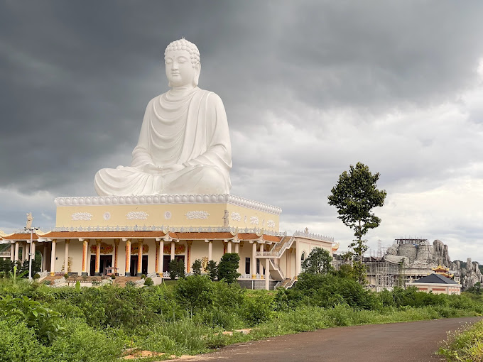
Possessing a 73m high Buddha statue, Van Thanh National Buddhist Pagoda is the perfect stop for Buddhists on their Binh Phuoc travel itinerary. Coming here, you will definitely have peaceful moments admiring the pagoda scene and immersing yourself in the pure atmosphere of the place of practice. About 100km from Saigon, Van Thanh Buddhist Pagoda is one of the most important projects in the world. Typical spirit of Binh Phuoc land, and also the pride of many generations of local Buddhists when owning the tallest Buddha statue in Southeast Asia up to the present time. If you have ever been impressed by the solemn, ancient and traditional space of Tan Khai Communal House, then Van Thanh National Buddhist Pagoda is a harmonious combination of Vietnamese Buddhist architecture and Japanese culture. The village will definitely make you overwhelmed and excited. Binh Phuoc is a land of many communal houses, temples and pagodas, so this place has always been an ideal stop for many Buddhists and those who love this type of tourism. spiritual calendar. If the temples in Binh Phuoc with their typical traditional architecture in the past are what impressed you, then when you visit the Van Thanh National Buddhist Pagoda, you will be able to admire many interesting and interesting things. more surprising. Based on the inspiration of the current chairman, Van Thanh Buddhist Pagoda is a harmonious combination of Vietnamese Buddhist architecture from both the North and South with Japanese culture, creating a pure practice space. , peaceful but also maintains its inherent solemnity and sacredness. From the first moment you stop at the three-entrance gate area, you will definitely be impressed by the 5-door design and two fake doors on the outside. In front of the gate of Van Thanh National Buddhist Pagoda are placed two statues of guardian angels guarding the gate, this further contributes to enhancing the solemnity of the place of practice. The temple gate is a system of three paths with the largest main door in the middle and two small equal doors arranged on both sides. The middle gate is built higher than the two side gates and the walls are built entirely of bricks, covered with white paint and carved with elaborate, sophisticated patterns. Meanwhile, the front of the gate was built higher and wider, with a carved image of two dragons flanking the moon attached to a scroll, symbolizing spiritual devotion to the gods according to belief. Meanwhile, the roof gate at Van Thanh National Buddhist Pagoda is designed in the Japanese roof style with a straight, sloping top and a curve at the top. The interesting point is that the Japanese roof does not have a dragon pattern on the roof like what we often see in temples built in the traditional Vietnamese style. Going inside, you will see the temple tower area with three very majestic floors. The tower's body is designed in a square shape with the body on the first floor being the largest, the higher it goes, the smaller it gets. The tower is carved with many delicate and meticulous patterns. The most prominent feature at Van Thanh National Buddhist Pagoda is the 73m high Buddha statue sitting on the temple roof. This was even the tallest statue in Southeast Asia and the tallest in Binh Phuoc province to date. The Buddha statue was built on a plot of land with an area of 8,100 square meters with the pose depicting a blooming lotus flower, and the roof is covered with flower petals blooming brilliantly under the gentle sunlight. Around the pagoda tower area is a spacious campus with cool space, contributing to portraying the inherent airy and pure beauty of this place. In addition to the impressive 73m high Buddha statue, on the grounds of the Van Thanh National Buddhist Pagoda, there is still a 30m high Maitreya Buddha statue that weighs up to 1 ton. This is what attracts a large number of Buddhists to come here to sightsee, burn incense and worship during important holidays of the year. With an impressive space and a 73m high Buddha statue, it is not surprising that Van Thanh National Buddhist Pagoda has become a magnet attracting many people to quickly come to this land to worship and enjoy. On your upcoming trip to Binh Phuoc, if you want to find some peace in your soul after tiring hours with all the worries and chaos out there, Van Thanh Buddhist Pagoda is an ideal stop for you. .
Binh Phuoc 978 view
From April to November
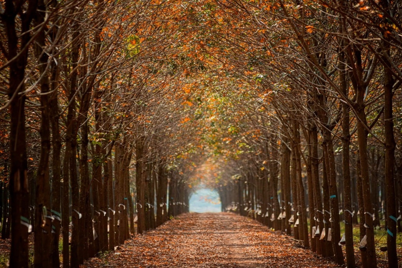
Bu Dang Rubber Forest is a large rubber forest in Bu Dang district, Binh Phuoc province. With its location right in the Southeast of the country, this is one of the most important rubber growing areas in our country. Besides economic value, rubber forests also bring extremely valuable value. big on tourism. This is an attractive destination for tourists who love nature and want to explore life in the forest. When entering this forest, visitors will be engrossed in looking at hundreds and thousands of lush green rubber trees stretching along. This is a scene that is likened to a majestic natural lacquer painting. Recently, the rubber forest is becoming a place that attracts many tourists to visit, take photos to check in or organize camping on weekends. If you have the opportunity to visit during the rubber leaf changing season, you will think you are lost in Korea right in the heart of Binh Phuoc. When entering Bu Dang Rubber Forest, you will be fascinated by the fresh feeling and natural fragrance. natural rubber tree. The air in the forest is fresh and clean without urbanization. This brings comfort and eases the stresses of urban life. Besides, you will find a harmonious interaction between humans and nature right here. The beauty of Bu Dang Rubber Forest lies not only in the landscape but also in its rich biodiversity. This place is the habitat of many rare species of trees, shrubs and animals. Encountering diverse bird species, wild animals and rare insects will no longer be too difficult. You will witness the bustling life and diversity of the ecosystem in the rubber forest. It can be said that the beauty of the Rubber Forest is a harmonious combination of lush natural landscape and cool green space. At the same time, it is also combined with thousands of green rubber trees to create a beautiful and enchanting scene. Bu Dang Rubber Forest allows visitors to participate in nature experience activities such as camping, picnicking and hiking. Walking and hiking in the rubber forest will bring quite a pleasant experience. This helps you relax, enjoy the green space and explore the beautiful natural landscape of the forest. At the same time, you can see the streams in the forest or beautiful waterfalls. In addition to relaxingly strolling on roads lined with rows of extremely fresh rubber trees. Suggest to you that this is a great place to check-in to make a vivid impression in the beautiful scenery of the Rubber forest. With a romantic and dreamy landscape as if from the West, Bu Dang rubber forest brings wonderfully beautiful photos. This location is also a wedding photography location chosen by many couples. And an interesting experience that you should try is visiting some rubber processing factories near the Bu Dang Rubber Forest area. You will have the opportunity to learn about the process of producing products from rubber trees. Finally, try local dishes at area restaurants and eateries. This is an opportunity for you to explore the unique culinary culture and experience the typical flavors of this land. In the summer, the sky of Bu Dang Rubber Forest is filled with fresh green. Every corner is filled with green trees and shade, creating an extremely fresh space. If you are passionate about the yellow and red leaves of autumn in Hanoi or the sights of the West, then the end of the year and early spring will be the ideal time to see them. At that time, the entire rubber forest suddenly changed color, with green leaves gradually turning yellow and then orange, creating a beautiful picture throughout the forest.
Binh Phuoc 978 view
From November to April
Dak Mai Waterfall belongs to Bu Gia Map National Park, located in Bu R'Nga village, Bu Gia Map commune, Bu Gia Map district. The waterfall is in a remote mountain district of Binh Phuoc province, so the path is quite difficult. If you start from Dong Xoai city center, you need to travel about more than 100km to get here. If traveling from Ho Chi Minh City, the distance is up to 220km. Therefore, despite its heart-touching beauty, this waterfall is rarely visited by tourists. Dak Mai Binh Phuoc Waterfall has a height of 12m and a width of 50m, located in the middle of quiet mountains and forests, with white foam all year round. Although this place does not have the overwhelming beauty like the waterfalls in the Central Highlands, it still possesses a natural landscape that is both wild and mysterious. When you visit Dak Mai Waterfall, you will be immersed in beautiful nature, immerse yourself in the fresh air, and explore the simple life of ethnic minority villages here. The waterfalls located in the Bu Gia Map National Park complex are mostly associated with heroic legends and indomitable stories of the nation's history. Thanks to its location far from crowded residential areas and the access road being quite arduous, in 1962, Dak Mai stream became the base of the Security Committee of Area 10. After the Dong Xoai victory in 1965, Dak Waterfall Mai continues to be chosen by our military and people as a base. Thanks to the advantageous location and the heroic fighting of our army and people, we completely destroyed the tricks of the US imperialists and completed the task of protecting the Central Command of the Regional Party Committee. The name Dak Mai waterfall comes from the stream of the same name, which is also the source of this waterfall. The waterfall has a very large area, up to 45 hectares. During the rainy season, when the water level increases, the waterfall becomes wilder, with a large amount of water flowing rapidly, causing white foam to appear day and night. If you come here in the dry season, you will see Dak Mai waterfall become very peaceful, gentle and quiet, like a white silk strip winding between the mountains and forests. Around Dak Mai Waterfall is a very rich ecosystem. Trees grow wild, beautiful little flowers bloom, bees and butterflies flutter, and birds chirp. Here, you will enjoy the fresh air, sit next to the waterfall, listen to the echoes of heaven and earth, feel the gentle breath of life, completely away from the sound of traffic, without the dust and smoke of the city. . Spread along Dak Mai Waterfall are many large round pebbles. Thousands of years of time and fast flowing water every day have eroded these rocks into smooth and unique shapes. You can bring snacks and drinks and organize an outdoor picnic with friends in the cool and fresh air. Exploring Dak Mai waterfall, you can also admire the skylight created by the hands of mother nature. These are two skylights formed by the vortex force of the water flow over many years. You can check-in many super quality "virtual life" photos. The downstream area of Dak Mai waterfall is very gentle, with many long and flat rocks. On both sides of the bank are tall clumps of bamboo and bamboo, growing vast, creating a lot of shade. The terrain is flat, with little weeds, so it is very suitable for you to camp overnight, fully enjoying the beauty of majestic nature. Each waterfall season has different beauty. Amidst the immense greenness of Bu Gia Map mountains and forests, Dak Mai waterfall is hidden, flowing white, this is an attractive and pristine tourist destination located adjacent to Bu Gia Map National Park.
Binh Phuoc 951 view
From December to April
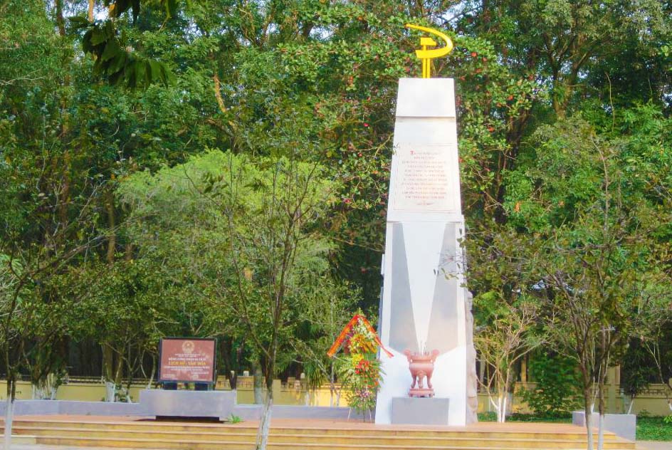
The site of the establishment of the Indochina Communist Party cell in Phu Rieng is located in Thuan Phu commune, Dong Phu district, Binh Phuoc province. Here, on October 28, 1929, the Indochina Communist Party Cell was established as the foundation for the later revolutionary movement of rubber workers in the Southeast region. Phu Rieng rubber plantation belonging to Michelin Company was established in Phu Rieng village, Ba Ra district, Bien Hoa province (now belongs to Dong Phu Rubber Joint Stock Company). When investing in exploiting and developing rubber here, French capitalists recruited hundreds of thousands of people from the Northern and Central provinces to the South to work as laborers. With the support of the colonial government apparatus, French capitalists severely and cruelly exploited the labor of the laborers such as: beatings, salary cuts, torture, harsh working regimes, homeless, hungry, lacking clothes, living in "hell on earth", causing "For every rubber tree that grows, a worker falls". The workers only knew how to react in spontaneous ways such as cutting down rubber trees, protesting, fleeing... but all were severely suppressed. Faced with that situation, in 1928, comrade Nguyen Xuan Cu was sent by the Revolutionary Youth Committee of the Northern Association to "proletarianize" the Phu Rieng rubber plantation. To lead the workers' struggle movements, in April 1928, the Revolutionary Youth Comrades' Association was established with comrade Nguyen Xuan Cu as Secretary along with comrade Tran Tu Binh and comrade Pham Thu. Hong, comrade Ta, comrade Hoa, comrade Doanh and comrade Song. This is the headquarters leading the fighting activities of Phu Rieng rubber workers. From this grassroots organization, implementing the policy of developing the Party organization, on October 28, 1929, on the banks of the Village 3 stream, the Indochina Communist Party Party Cell, also known as the Phu Rieng Party Cell, was established, led by Comrade Nguyen Xuan Cu as Secretary. This is the first Communist Party cell of Binh Phuoc province and also the first cell of the Vietnamese rubber industry. The birth of the Indochina Communist Party Cell - Phu Rieng Party Cell promptly responded to the requirements of revolutionary struggle, quickly leading rubber workers to demand their rights through different, organized forms of struggle. organizations and plans in many forms. Among them, a typical strike of 5,000 rubber workers in 1930 created the heroic "Phu Rieng Do", destroying "Hell on Earth". After 8 days (from January 30, 1930 to February 6, 1930), the struggle won a great victory, with far-reaching influence, contributing to promoting the struggle movement of the Vietnamese working class. a victorious step and a historical milestone in the country's revolutionary struggle. The site of the establishment of the Indochina Communist Party cell in Phu Rieng is a place that marks the value and importance of the correct policy and the strong development process of the Party organization. Today, the old "Phu Rieng Do" has become a vast land of rubber, contributing "white gold" to building and creating an increasingly rich and beautiful hometown of Binh Phuoc. In 1985, Dong Phu Rubber Joint Stock Company built a memorial. In 2019, Vietnam Rubber Industry Group invested in embellishing the monument. The location of the establishment of the Indochina Communist Party Cell in Phu Rieng more spacious. Today, the relic of the founding site of the Indochina Communist Party cell in Phu Rieng is a place to review the tradition of revolutionary struggle, affirming and enhancing pride in the contributions of rubber workers in particular. in particular, the working class, the army and people of Binh Phuoc in general for the cause of national independence. With those typical historical values, on February 12, 1999, the site of the establishment of the Indochina Communist Party Cell in Phu Rieng was decided by the Minister of Culture and Information to be classified as a historical relic. nation. Source: Binh Phuoc Provincial Museum Electronic Information Page
Binh Phuoc 2222 view
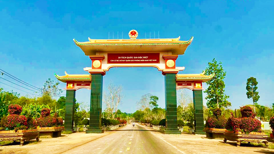
The South Vietnam Liberation Army Command Base Relic is located in Loc Thanh commune, Loc Ninh district, Binh Phuoc province. This place was formerly the Forward Command Post of the Nguyen Hue campaign in 1972. On April 7, 1972, Loc Ninh was liberated, then became the capital of the Provisional Revolutionary Government of the Republic of South Vietnam. . To accommodate the new situation beneficial to the Southern revolution, the Central Bureau and the Regional Command decided to move the Regional Military Commission base from Soc Con Trang (Tay Ninh) to Ta Thiet Soc. The South Vietnam Liberation Army Command base was built in 1973 in the Ta Thiet forest, so it is also called "Government Forest" or Ta Thiet Base. Here, under the canopy of large trees and tangled bamboo forests, is where high-ranking leaders of the Party and State once lived, fought and directly directed the struggle to liberate the South. : Commander Tran Van Tra, Deputy Commander Nguyen Thi Dinh, Political Commissar Pham Hung, Deputy Commander and Chief of Staff Le Duc Anh... Particularly, Senior General Tran Van Tra's house and workplace are built according to stilt house architecture. in an empty glade in the squirrel area of the Khmer ethnic people. In addition, at the Base there is also a system of other service works such as Hoang Cam kitchen, briefing tunnel, conference hall... All are built in a semi-submersible style (half submerged, half above ground) to limit light. The lights go out at night, ensuring safety if the enemy bombs. The materials used are mainly forest trees, the roof is thatched, and each building has a system of escape trenches and shelters. The command bunkers, information bunkers, military medical bunkers... were built quite large, for convenient work as well as precautions when the ground is unsafe. The South Vietnam Liberation Army Command base in Ta Thiet fulfilled its mission of protecting and developing the activities of the Military Commission and the Regional Command in the final phase of the resistance war against the US. Important events took place here: A place to welcome high-ranking delegations from the Politburo, the General Staff, and the Central Bureau to discuss plans to build the armed forces, and a place to implement plans. operations, Directives and Resolutions of the Central Government. In particular, in 1975, here, the Ho Chi Minh Campaign Command was established, making an important contribution to the glorious victory of the historic Ho Chi Minh Campaign, completely liberating the South and reunifying the land. water. In 1994 - 1995, the relics of the South Vietnam Liberation Army Command Base were restored, embellished and brought into play to promote their value. By 2018, the Provincial Party Committee and People's Committee of Binh Phuoc province will carry out a project to renovate, embellish and add items such as: Memorial House, Reception House, Traditional House, Memorial, Gate to the relic site, Landscape lake… Ta Thiet Base Relic is a place marking the activities of the South Vietnam Liberation Army Command in the resistance war against the US for national liberation and national reunification. Today, the relic is both a red address with a meaning of gratitude and education for revolutionary traditions, as well as an ideal tourist destination for tourists. With great historical significance, November 16, 1988 , the Minister of Culture decided to classify the relic of the Command of the Liberation Army of South Vietnam as a national historical relic. On December 23, 2015, the monument was decided by the Prime Minister to rank as a special national historical relic. Source: Binh Phuoc Provincial Museum Electronic Information Page
Binh Phuoc 2048 view
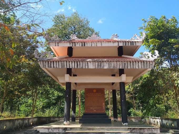
The relic of the uprising of the S'tieng people - Phu Rieng commune against the French colonialists on October 25, 1933 (also known as Tay Tay's grave) is located at Phu Rieng intersection, Phu Rieng commune, Phu Rieng district, Binh Phuoc. This place was built by the French colonialists in 1933 to commemorate District Chief More - one of the notoriously cruel rulers of the French colonialists in Ba Ra district at that time. In the early years of the twentieth century, the French colonialists promoted rubber planting and exploitation in Cochinchina, including Ba Ra district in Bien Hoa province. France considers this region a sacred forest and poisonous water and often calls it with the ironic name "the land of all teeth and ears straining". They turned this into a place to exile opponents and force them to do hard labor to serve the rubber plantation capitalists. At the same time, here, the French colonial government implemented a sinister policy of appropriation, using every trick to exhaust the labor and humiliate the ethnicity of the S'tieng people. Because of their national identity and unable to continue their harsh life, the S'tieng people stood up to fight against the enemy. In 1933, two brothers Dieu Mon and Dieu Mot (in Soc Bu Sum), who had participated in leader N'Trang Long's insurrection movement in the 1920s, stood up to campaign and gathered about 200 young people. The S'tieng clan joined the insurgent army. After being established, the insurgent army discussed and planned to destroy District Chief More. On October 25, 1933, the insurgents organized an ambush. More rode a horse and urged soldiers to investigate the people "going to work" (going to serve, working for free), then fell into the ambush of the insurgents. District Chief More and his accompanying soldiers were destroyed by the insurgents of Mr. Dieu Mon and Dieu Mot. The French colonialists, after suppressing the uprising of the S'tieng insurgents, set up a memorial stele in the name of District Chief More. But for our people, this is a place that marks a resounding victory, a victory that has entered the hearts of every Ba Ra citizen, has great historical significance and value, and contributes to educating patriotism. , the spirit of fighting for independence and freedom of the S'tieng people in particular and the Vietnamese people in general. With typical values, on May 29, 1989, the Minister of Culture decided to classify the relic of the Uprising of the S'tieng people - Phu Rieng commune against the French colonialists on October 25, 1933 as a relic. national historical record. Source: Binh Phuoc Provincial Museum Electronic Information Page
Binh Phuoc 1997 view
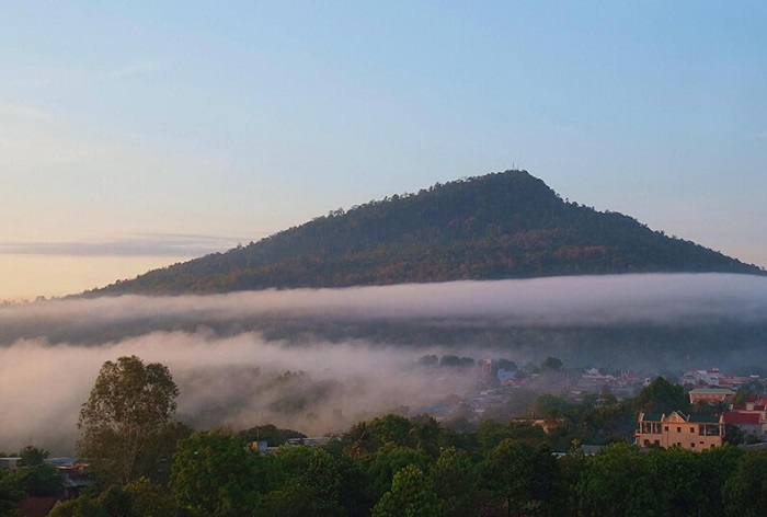
Ba Ra Mountain is located in Son Giang ward, Phuoc Long town, Binh Phuoc province. This is one of the three highest and most majestic mountains in the South. Legend has it that the founder of the S'Tieng people had two younger sisters; He built Ba Den mountain for his first sister and Ba Ra mountain for his second sister to protect the land of the S'Tieng people. The S'Tieng people call this mountain with a respectful name: "Bônom Brah", meaning "God mountain" or "Yang Yumbra Mountain God" is the god worshiped on the top of Ba Ra mountain. Khmer people call it "True Buddha" mountain. With an altitude of 723m, the rugged terrain of Ba Ra Mountain is a place that marks many heroic and resilient victories as well as many anecdotes, associated with important historical events. Here, during the two resistance wars against the French and the Americans, it was the base of operations for revolutionary soldiers. This is considered a solid revolutionary base. From 1925 to 1941, the French colonialists built a large prison at the foot of the mountain including 3 camps: Camp A to imprison thieves and robbers; Camp B imprisons female prisoners, political criminals, and people suspected of being communists but not convicted; Camp C holds political prisoners. The prison guards used many barbaric tricks to torture prisoners, but with the spirit of self-reliance, the communist soldiers turned this prison into a place of political struggle with the French colonialists. This "God" mountain is associated with the resistance war of the people of Phuoc Long in particular and our people in general. At Bang Lang Hill, a stele house and a memorial temple were built to commemorate the soldiers, soldiers and people. compatriots sacrificed their lives in the resistance war in the Ba Ra area. Ba Ra Mountain is a beautiful landscape famous for its winding Be River, Mother Waterfall, Mo Waterfall, and forests with a rich diversity of flora recognized by the Ministry of Forestry (now the Ministry of Agriculture and Rural Development). ) classified into the special forest system of the country. From Bang Lang Hill, step up 1,767 stone steps to reach the top of the mountain. The road up the mountain is quite beautiful covered with a green color of bamboo and bamboo, especially on both sides of the road there are many ancient trees estimated to be several hundred years old. year old. On the top is the antenna of Binh Phuoc Radio and Television Station, 48m high to bring television waves to remote areas in the province. There is also a shrine here worshiping the Holy Mother Buddha Thien Hau and the goddess of the land (Ba Ra mountain), which is very sacred. There is a project to build a Buddhist spiritual area associated with eco-tourism at the relic. Ba Ra Mountain also has Bat cave and Ba Bay Tuyet cave, which are deep and wide and very beautiful. This was the refuge of our army and people during the two resistance wars against the French colonialists. With great values, Ba Ra Mountain - Thac Mo relic was recognized and ranked as a historical relic and national landscape by the Ministry of Culture and Information on April 20, 1995. Source: Binh Phuoc Province Electronic Information Portal
Binh Phuoc 1872 view

VK98 Gasoline Tank Relic - Fuel Warehouse is located in Loc Quang commune, Loc Ninh district, Binh Phuoc province. The relic belongs to the special national historical relic system of Truong Son - Ho Chi Minh Trail. The VK98 fuel depot was built in 1974, located around hill 117 (the name of a high point in the military map) in Loc Quang commune, Loc Ninh district, with an area of 10 hectares, including 7 tanks, each tank has the capacity containing 250,000 liters, VK98 total fuel warehouse has a reserve of 1,750,000 liters. The petroleum tanks are welded with steel, each 10m in diameter, 3.5m high and 100m apart in a triangular shape, buried underground, surrounded by forest trees with dense piles. . The tanks are connected to each other by pipelines, at a height above the road surface, so vehicles coming to get gas do not have to use a vacuum cleaner but only need to open the valve to let the material flow into the tank. A company of 30 tank trucks (tank trucks), day and night, transported gasoline and oil from VK96 Bu Gia Map station to gather at the VK98 fuel depot and transport gasoline and oil to the battlefield. After the country's liberation, the petroleum tanks were dismantled by Military Region 7 Logistics, leaving one tank remaining to serve the sightseeing and learning needs of the people. Along with other petroleum gathering points, the VK98 Gas Tank - Fuel Warehouse relic marked a time of "Cutting along Truong Son to save the country", successfully completing the task of supplying petroleum, contributing to the victory. of the historic Ho Chi Minh Campaign, completely liberating the South and reunifying the country. Today, the relic has become one of the places to learn and research about the petroleum pipeline system in particular and the legendary Truong Son road in general during the resistance war against the US. With typical historical values, the Minister of Culture decided to classify the VK98 Gas Tank - Fuel Warehouse relic as a national historical relic on April 21, 1989. On December 9, 2013, the VK98 Gas Tank - Fuel Warehouse relic in Loc Quang commune, Loc Ninh district, Binh Phuoc province is a relic in the Truong Son Road - Ho Chi Minh Road relic system that was approved by the Prime Minister. vetoed the decision to rank a special national historical relic. Source: Binh Phuoc Provincial Museum Electronic Information Page
Binh Phuoc 1706 view
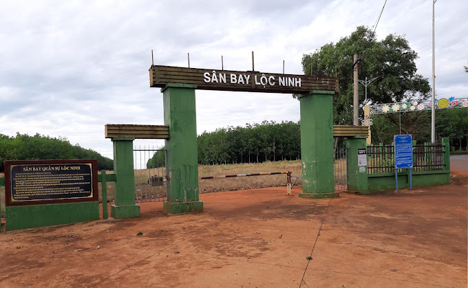
Loc Ninh military airport is located about 500m from the center of Loc Ninh town. The airport is entirely assembled with iron grilles (Tec-nich) instead of concrete, located on a flat hill with an area of 50,000 square meters. This is an airport built by the US puppet on March 10, 1965 to be used for supplying food, ammunition and moving war vehicles to Loc Ninh - Cambodia. Due to time and many other factors, Loc Ninh military airport is no longer intact as before, only the runway remains without iron grills. After Loc Ninh was liberated on April 7, 1972, the airport belonged to the provisional revolutionary government, and was the place that marked many important historical events: January 31, 1973, led by Senior Lieutenant General Tran Van Tra. The head of the military delegation of the Provisional Revolutionary Government of South Vietnam flew to Saigon to attend the first meeting of the Four-Party Military Joint Committee at Camp Davis (Saigon). Also here, on February 12, 1973, we returned 27 American officers, soldiers and military personnel. They thanked our soldiers for helping them escape death and reunite with their families. also welcomed hundreds of outstanding and loyal children back from American and puppet prisons. Between two rows of puppet soldiers with guns drawn, the prisoners could not move their steps, they had to help and carry each other. Go, strip off prison clothes and shout the slogan "Nothing is more precious than independence and freedom". Thousands of Loc Ninh compatriots held flags and flowers to welcome the returning winners with indescribable emotions and tears (quote from Loc Ninh history and traditions (1930 - 2000)). From February 12, 1973 to March 28, 1973, 4 rounds of returning prisoners of war took place at this airport and, along with 5 other locations across the country, returned 26,492 people, in the following months. In April, May, and June, we continued to return prisoners of war. On March 7, 1974, the last group of prisoners of war was returned, including Ms. Vo Thi Thang, the image of her smile - the female student fighting for national independence who was imprisoned as she stepped off the military airport. Loc Ninh incident. It is a beautiful, unforgettable image. That smile entered poetry as a beautiful image: "Very naturally, that girl brought a smile into history for thousands of years" and that smile also proved her previous strong statement. "Will your government exist for 20 years to imprison me?". Also here on September 12, 1973, we welcomed the International Commission delegation and the ambassadors and deputy heads of delegations of the International Commission to visit and work in Loc Ninh. Later, many Americans went to the old battlefield during their trips to Vietnam to remember "that day of Loc Ninh". History has turned a page, the past has ended, but for the Loc Ninh family, those days will never be in the past. The Loc Ninh Military Airport relic is not only a source of pride but also evidence denouncing the crimes of aggression committed by the imperialists and their henchmen, thereby educating the revolutionary spirit and the tradition of love. water for young generations today and tomorrow as well as attracting tourists coming to Binh Phuoc province. Loc Ninh Airport was recognized as a national historical relic by the Ministry of Culture on December 12, 1986. Source: Binh Phuoc Province Electronic Information Portal
Binh Phuoc 1694 view
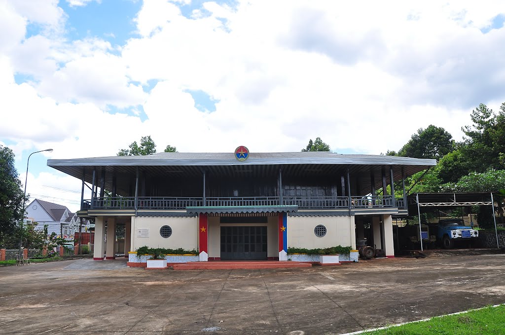
The historical site of the Provisional Revolutionary Government of the Republic of South Vietnam is a house in Loc Ninh Town, Loc Ninh District, Binh Phuoc Province, at the end of the Ho Chi Minh Road - the North-South strategic road. On April 7, 1972, Loc Ninh was completely liberated. This was the first district liberated in the entire South. Since then, Loc Ninh is the gathering place of Political, Military, Logistics agencies... Especially the House of Relations - Headquarters of the Provisional Revolutionary Government of the Republic of South Vietnam. The house was built in 1911, as the office of the French rubber company Xeo - Xo, to manage the exploitation of rubber latex in Loc Ninh. The house is built in the style of stilt houses of ethnic minorities, so people in the area still call it "Cao Can" House. During the Nguyen Hue campaign (1972), the house was completely destroyed. In March 1973, in response to the needs of the work situation on the diplomatic front, the Provisional Revolutionary Government of the Republic of South Vietnam agreed to choose the location of the foundation of the "Cao Cang" house to build the revolutionary headquarters with Design drawings by architect Huynh Tan Phat. The house was built to welcome domestic and foreign diplomatic delegations, so it is called "The House of Relations". After more than a month of construction, the grand and spacious project was completed, including a ground floor and a first floor. The ground floor is built of solid concrete, used for meetings, mitting and is also where cultural and artistic activities take place. The upper floor is built of wood, surrounded by railings designed in the style of a stateroom, with a "5-roof, 4-roof" corrugated iron roof painted red. In this room, in 1973, a four-way military conference between Vietnam and the United States took place; The four-party conference discussed the provisions signed in the Paris Agreement under the supervision of the ICCS International Committee, including four member countries: Poland, Canada, Hungary and Indonesia. During meetings, there is a clear division from the aisles, meeting seating positions and resting positions during breaks... are all arranged separately. Representatives of the four delegations sat in a large round table, the International Committee sat in a small round table, and four small tables in the four corners of the house were the seating positions of the four parties' attachés. All are under the flag of the National Front for the Liberation of South Vietnam. On both sides there are two stairs going up. Looking out from inside the house, the staircase on the right is the path of the Vietnam People's Army, the left is the path of the American military and the Republic of Vietnam. Choosing a square or round table for a meeting is also an issue of concern to all parties. When meeting at Camp David (Saigon) or meeting in Paris, the Four-Party Joint Military Committee used square or rectangular tables to sit at meetings, but when meeting at the House of Exchange, they chose round tables. Because a round table shows equality and respect between parties, but if it is a square or rectangular table, when one of the four parties stands up to speak in the meeting, it will be like that party is the chairman of the meeting. When using a round table, all parties are equal. The birth of Giao Te House has fulfilled its historical mission, being a testament to the defeat of American imperialism and its henchmen, in addition to the heroic and clever struggle of our army and people. on both military and diplomatic fronts in the struggle to protect national independence and unify the country. The Relics of the Provisional Revolutionary Government Headquarters of the Republic of South Vietnam (House of Relations) were recognized by the Ministry of Culture as a National Historical Monument on December 12, 1986. Source: Binh Phuoc Province Electronic Information Portal
Binh Phuoc 1626 view
Ho Chi Minh Road - a bridge connecting the great northern rear with the great southern front line, was a solid base of the southern Indochina battlefield in the resistance war against America. As we know, during the resistance war against the US, petroleum fuel was an urgent requirement to serve the large-scale and speedy war. Binh Phuoc, the land of "the hard-working but heroic East", is very honored and proud when in the province there are two relics belonging to the special relic system of Truong Son - Ho Chi Minh trail, the relics of Petrol Tank - VK98 fuel depot and VK96 petroleum pipeline terminus. Through extremely arduous years, despite terrain conditions, harsh weather and fierce enemy attacks, after 6 years (from 1968 to 1974), Truong Son pipeline soldiers has built, protected and operated smoothly a 5,000km long petroleum pipeline and a petroleum storage system of nearly 30,000 tons from the northern border of the country across Truong Son to Bu Gia Map. Bu Gia Map is the final point of the North-South petroleum pipeline. From here, the petroleum source is transported by tanker truck (completely secret) to the gasoline tanks - VK98 and VK99 fuel warehouses in Loc Ninh. The VK96 petroleum pipeline end point relic also has other names such as: symbols K22, O30. Later, he used the codename VK. The end point of this petroleum pipeline system is VK96, followed by the gasoline tanks in Loc Ninh are VK98 (Loc Quang), VK99 (Loc Hoa). The relic is the place that marks the great and silent victories of the soldiers, petrol soldiers, youth shock troops, local soldiers and civilians... during the years of resistance against the US to save the country of our nation. is a testament to one of the legends of the historic Truong Son road, which is the Truong Son petroleum pipeline system, one of the miracles of Group 559. This is one of the three main systems of the road. undermine Ho Chi Minh's strategy, demonstrating the tenacious spirit and iron will of our army and people in the resistance war against America to save the country. The victory of the resistance war against America to save the country is the victory of Vietnamese revolutionary heroism. In particular, the petroleum pipeline system - Truong Son road is the embodiment of iron will, expressing the will to win, courage, desire for independence, determination to liberate the South, and recover the mountains and rivers. about a bond of the entire Party, entire army and entire people, a shining symbol of the faithful fighting solidarity between the three countries of Vietnam - Laos - Cambodia. Truong Son route has existed in the history of the resistance war against the US to save the country as a legend with the name "Ho Chi Minh Trail". The system of petroleum pipelines - Truong Son road, the road connecting South - North associated with many heroic victories of the entire nation during the years of resistance war is forever a source of great pride, encouragement and encouragement. members of our entire army and people in the work of building and protecting our Fatherland today. With such great historical significance, the VK98 Gasoline Tank - Fuel Warehouse relic in Loc Ninh district and the VK96 petroleum pipeline end point relic in Bu Gia Map district, Binh Phuoc province are located in the Truong Son - Binh Phuoc province relic system. Ho Chi Minh Trail was recognized by the Prime Minister as a special national monument on December 9, 2013. Source: Binh Phuoc Province Electronic Information Portal
Binh Phuoc 1590 view
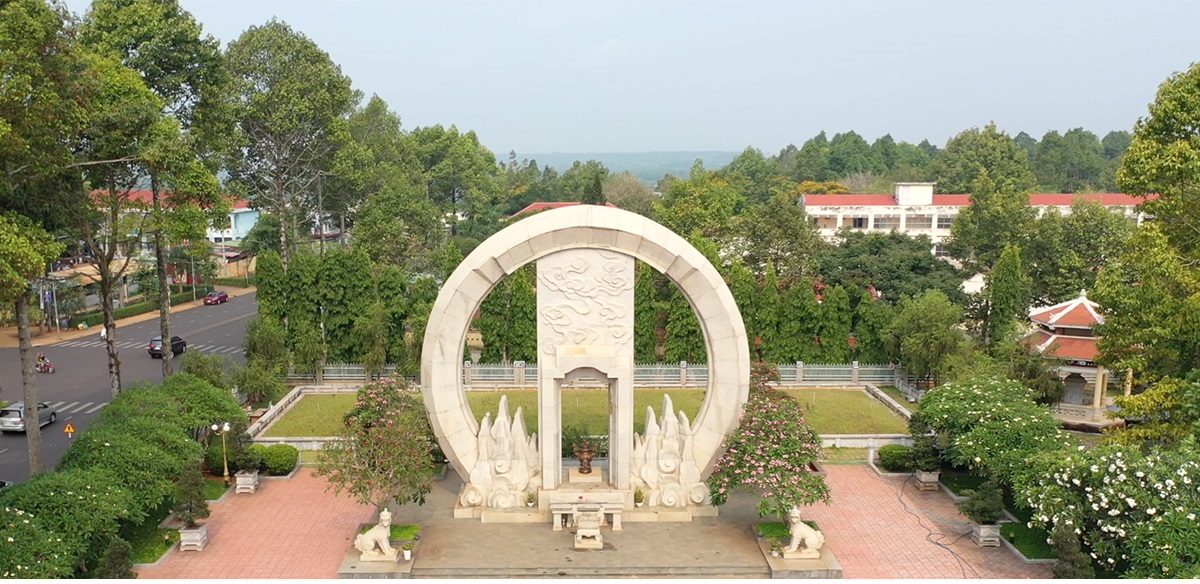
The relic of the grave of 3,000 An Loc compatriots who were massacred by the US imperialists on October 3, 1972 (also known as the collective grave of 3,000 people) is located in An Loc ward, Binh Long town, Binh Phuoc province, and is one of the Evidence marks the war crimes that the US and puppets committed against our people in general and the people of Binh Long in particular during the resistance war against the US. In 1971, implementing the policy of the Politburo, the Central Executive Committee of the Communist Party of Vietnam met and approved the determination to defeat the "Vietnamization of the war" strategy of the US imperialists and their henchmen, the Nguyen Hue Campaign. was opened with the main attack direction on Road 13 and the decisive battle area of Loc Ninh and An Loc in Binh Long province. On April 7, 1972, Loc Ninh was completely liberated, our troops continued to attack to liberate An Loc town. Faced with the stormy attack of the main force, the enemy tried their best to hold the town because if An Loc was lost, Binh Long would be lost and "Binh Long is gone, Saigon is gone". During 32 days and nights (from April 13 to May 15, 1972), the fighting took place extremely fiercely, the enemy concentrated a large amount of firepower, artillery, bullets, and bombs to plow the ground, thousands of compatriots. murdered, property and houses were heavily destroyed. The enemy also cruelly let a B52 plane drop bombs on An Loc town hospital, where most people gathered to avoid artillery fire and where injured enemy soldiers were being treated, causing many deaths. . To deal with the number of casualties, the enemy used vans and bulldozers to collect and bulldoze thousands of corpses into burial pits, creating a mass grave of over 3,000 people and erecting a stele "Fatherland's credit" to commemorate the deaths. deceive the people. Today, the relics of the graves of 3,000 An Loc compatriots who were massacred by the US imperialists on October 3, 1972 have been invested in and renovated, including the following works: Memorial, Memorial Stele House, Reception House... The relic is A place to commemorate the sacrifices and losses of the Regional Main Army and the people of Binh Long during the resistance war against the US. It is a place for people and tourists to commemorate and learn about the historical traditions of the revolutionary struggle. heroic and glorious of the soldiers and people of Binh Long town. On April 1, 1985, the site of the graves of 3,000 An Loc compatriots who were massacred by the US imperialists on October 3, 1972, was decided by the Minister of Culture to be classified as a national historical relic. Source: Binh Phuoc Provincial Museum Electronic Information Page
Binh Phuoc 1533 view
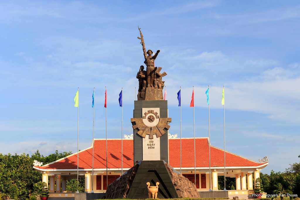
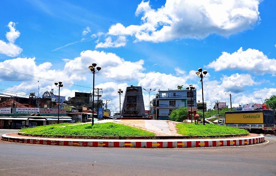
Tau O is the name that comes from Tau O stream flowing across Highway 13 in Hamlet 4, Tan Khai commune. During the Nguyen Hue Campaign, the Tau O blocking point was located about 400m north of the Tau O culvert (the section of the Tau O stream flowing through Highway 13). This is an important key point in the blocking system of Division 7. The victory of the Tau O Blockade contributed to the overall achievements of the Nguyen Hue Campaign in the 1972 Strategic Offensive, contributing to bringing our nation's resistance to the stage of complete victory both militarily and in parliament. situation, forcing the US to sit at the peace negotiation table, sign the Paris Agreement, ending the war in Vietnam. To commemorate the officers and soldiers of Division 7, soldiers and local people in the 1972 Nguyen Hue Campaign who sacrificed for national independence, in 2009, received material attention from the Provincial Party Committee and Provincial People's Committee. Binh Phuoc, Binh Duong province, Dong Nai province, City. Ho Chi Minh City, the Veterans Liaison Committee of Division 7, Division 7 organized the construction of the Tau O Victory Monument on an area of 11,451.7m2. The project includes 2 main items: Memorial stele house and the Victory Monument of the O-Train checkpoint. The relic has become a red address for trips back to the origin, sightseeing, and studying of people inside and outside the province. The Tau O Block Victory Site Relic is a typical relic with great historical significance and value. On March 29, 2012, the Ve O Passage Victory Site relic was decided by the Minister of Culture, Sports and Tourism to be classified as a national historical relic. Source: Binh Phuoc Province Electronic Information Portal
Binh Phuoc 1496 view


 vn
vn en
en ja
ja ko
ko zh
zh VIP member benefits