Explore the history, culture, people and beautiful landscapes of Vietnam on the 63Stravel travel app
Download the 63stravel app


Dien Bien 525 view

Download the 63Stravel app to immerse yourself in countless beautiful photos of Vietnam
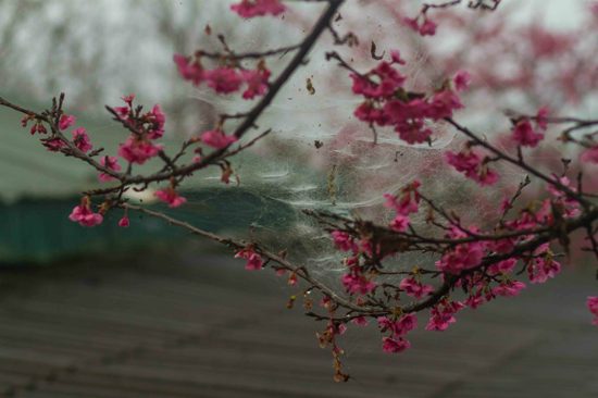
Peach blossom petals are dreamily beautiful in the morning
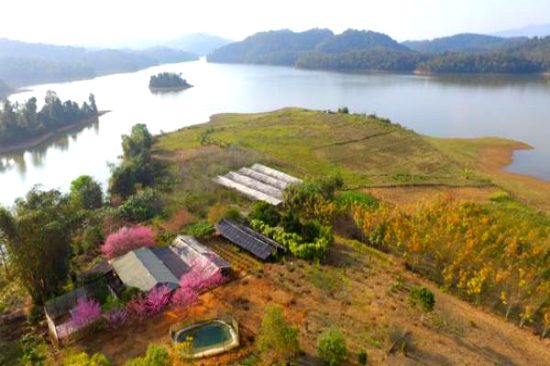
The charming landscape of Dien Bien cherry blossom island
Muong Phang cherry garden is an ideal place for a spring trip

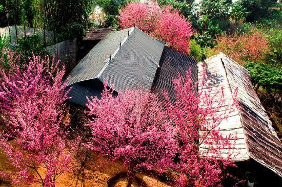
Young people can comfortably check-in amid the romantic cherry blossom garden
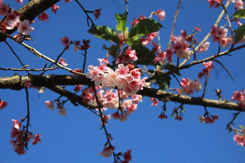
Bunches of cherry blossoms are bright in the early morning sunlight
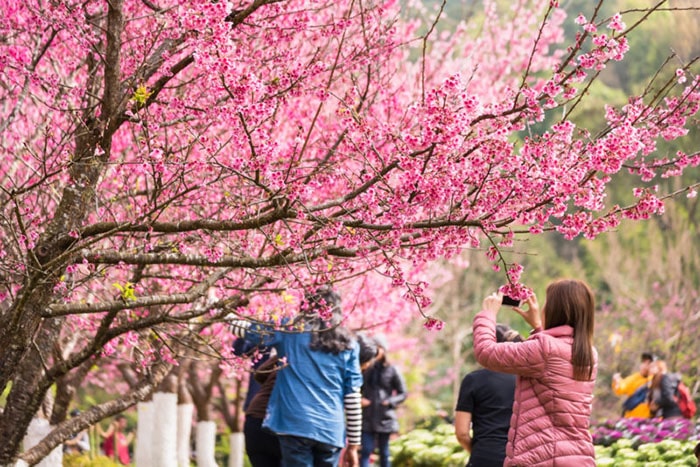
The cherry blossom garden attracts hundreds of tourists to visit each year


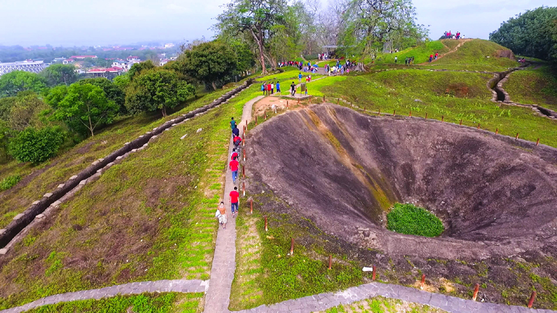
The Dien Bien Phu Battlefield relic site includes 45 component relics. This is a historical space and also an outstanding tourism product, contributing to traditional education for the young generation, reminding Vietnamese people of the heroic memory of the Dien Bien Phu victory "illustrious in five continents, earth-shattering" while bringing economic value to the locality. During these historic days of May, many delegations flocked to Dien Bien Phu city (Dien Bien province) to visit the old battlefield on the occasion of the 65th anniversary of the Dien Bien Phu Victory (May 7, 1954 - May 7, 2019). 2019). There have been a lot of changes in the land that was once a fierce battlefield in the past, with the 56 day and night campaign of "cutting mountains, sleeping in cellars, pouring rain, squeezing rice" by our army and people, successfully ending the battlefield resistance. period against the French colonial invasion. The Dien Bien Phu Battlefield relic complex is now one of more than 100 special national monuments in the country and plays an important role in the tourism development of Dien Bien province. The Dien Bien Battlefield relic complex includes outstanding relics such as: A1 Hill, Doc Lap Hill, Hong Cum base, Him Lam, Muong Thanh bridge, Dien Bien Phu base group command tunnel (or Do tunnel). Sand), Victory Monument, Cannon Monument, Dien Bien Phu Campaign Headquarters... These relics have left a deep impression, attracting many tourists to visit when coming to Dien Bien. Located east of the center of Dien Bien Phu stronghold group, A1 hill has the most important position in the system of 5 hills protecting the center of Muong Thanh. Here, on the night of May 6, 1954, our troops dug a tunnel, placed an explosive weighing nearly 1,000kg and set it on fire. By the morning of May 7, 1954, our troops had complete control of A1 hill, paving the way for the final general attack on the stronghold group headquarters and achieving complete victory. Hill A1 is now a tourist attraction for domestic and international tourists with tunnels, trenches, blockhouses, and tanks preserved almost intact. Here, tourists can experience pushing bicycles, cooking with Hoang Cam stoves, listening to veterans tell stories... General De Cat's command bunker is located in the center of the Dien Bien basin. This is the basement with the working and resting rooms of General De Cat and the Dien Bien Phu base group command. This is also the place that marks the tragic defeat of an expeditionary army with the image of the commanding general and all officers under his command raising their hands to surrender and our soldiers raising the flag of determination to win and ending the war. Translating the history of Dien Bien Phu. Another relic that cannot be ignored along with the epic poems about Dien Bien soldiers is the artillery pulling Duong relic. This legendary route has entered the nation's history and become legendary. Using only human strength and rudimentary tools, but with patriotism and heroic spirit, our army and people opened routes on winding and dangerous mountain slopes to pull artillery into the battlefield. 20km from the center of Dien Bien Phu city is the campaign headquarters located deep in the Muong Phang forest. This was the headquarters of the Dien Bien Phu Campaign Command from January 31 to May 15, 1954. During the days here, General Vo Nguyen Giap made many important and historic decisions. Muong Phang Forest has become a symbol of the strength of the Vietnam People's Army and is called "General's Forest" by the people. In the complex of Dien Bien Phu Battlefield relics, a project that was born in peacetime but plays a very important role is the Dien Bien Phu Historical Victory Museum. This project was completed in 2014, on the occasion of the 60th anniversary of the Dien Bien Phu Victory. The museum has a shape that simulates the helmet of our soldiers in the past. This is where artifacts from the historical Dien Bien Phu campaign are kept, including 2 display areas: Outside, there are 112 artifacts that are weapons used by the Vietnam People's Army and the French army, inside. Displaying 274 artifacts and 202 documentary photos. The museum has contributed to promoting the value of the historical complex of Dien Bien Phu battlefield and is a highlight attracting tourists to Dien Bien.
Dien Bien 1715 view
From January to December
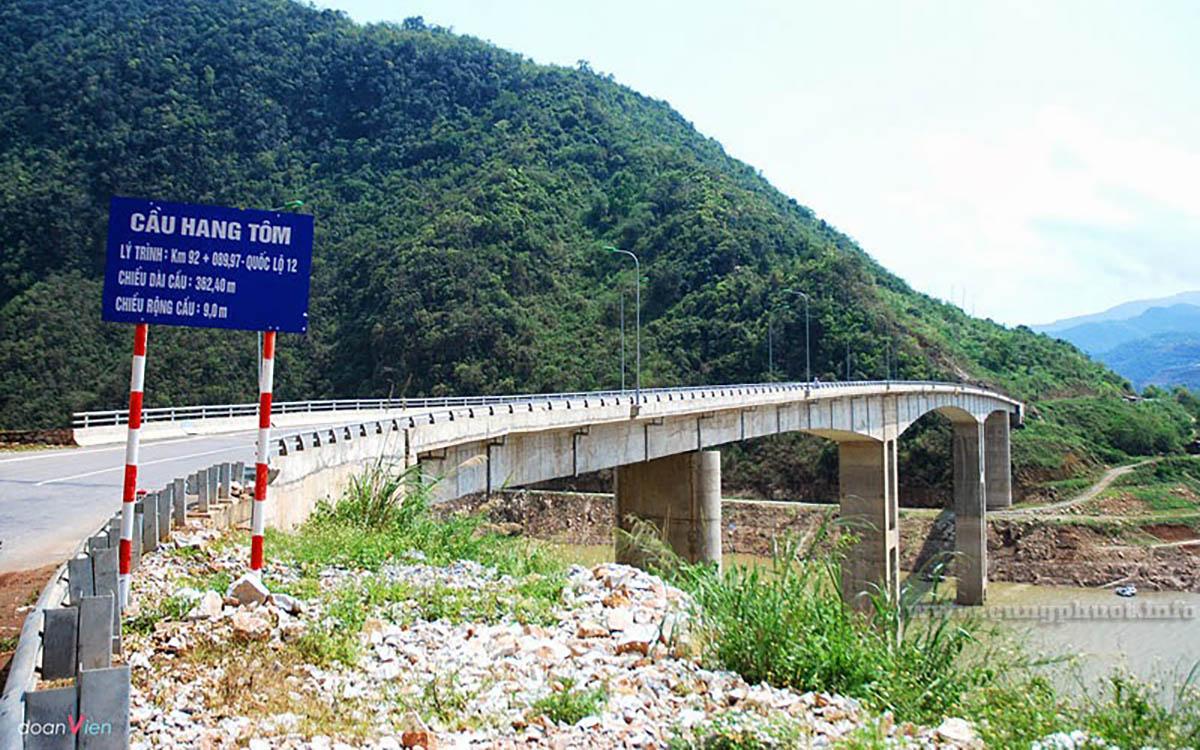
The old Hang Tom Bridge was previously famous as the most beautiful cable-stayed bridge in the Northwest, connecting Muong Lay (Dien Bien) and Phong Tho, Sin Ho of Lai Chau. The reason the bridge is called Hang Tom is because this part of the river used to have too many shrimp. About 50m from the bridge, there is a "pool" of very cool water, shrimp from the Da River flock there to lay eggs, the whole stretch of the river is densely packed with shrimp. Every day, people take turns going up there to catch them and eat them. But the people around this area have an unwritten custom: each family can only arrest for about an hour before the other family continues. In the late 1960s, Hang Tom Bridge began to be built. That day, Chinese experts and workers also came to help us build the bridge. However, in 1968, China had a cultural revolution, and all its experts and workers withdrew home. Fortunately, the item considered to be the most difficult, the cable car, had been pulled, leaving only the finishing stages remaining. But it was not until 1973 that Hang Tom Bridge was inaugurated. That day was truly a big festival for tens of thousands of Northwest people. Thousands of people came from all over to eat, eat rice balls, and walk for several days to see with their own eyes and once cross the dream bridge. Tom Cave is a highlight for the Northwest region. Because of the majestic and wild beauty of Hang Tom Bridge, in recent years, tourists, Westerners as well as ours, have flocked here, especially since the emergence of the backpacking tourism movement. In November 2012, Son La hydroelectric power station flooded, the entire old Muong Lay town, including Hang Tom bridge, sank deep under Song Da lake, ending 40 years of operation of the historic bridge. Right near the old Hang Tom bridge location, a new bridge was built to replace the task, 70m higher than the old bridge.
Dien Bien 1713 view
From January to December
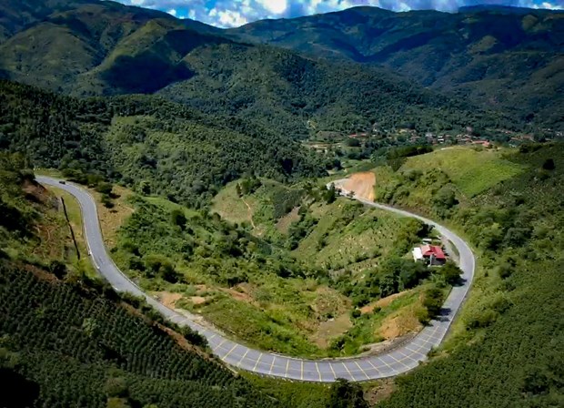
Pha Din in Thai is called "Pha Din", in which "Pha" is heaven, Din is "earth". The name of this pass means the place where earth and sky intersect - the name is enough to help people imagine the remoteness and danger here. Pha Din Pass is about 100km from Dien Bien Phu city. This is considered the boundary between Dien Bien and Son La provinces. Pha Din is located at an altitude of 1000m above sea level, with a total length of about 32km. The starting point of the pass is 66km from Son La City, and the end point is about 84km from Dien Bien Phu City. Pha Din, along with O Quy Ho, Khau Pha, and Ma Pi Leng, make up the four legendary passes of the Northwest highlands. Tourists from far away who want to conquer this great pass need to come to Hanoi by bus, train or it is best to book a plane ticket to Hanoi. From Noi Bai airport, visitors can book an airport shuttle on Traveloka to get to the city center. From Hanoi, to Son La - the starting point of Pha Din Pass by sleeper bus, limousine or motorbike. This pass is located on Highway 6, connecting the two provinces of Son La and Dien Bien. Backpackers starting from Hanoi will travel along Highway 6 through Moc Chau - Yen Chau - Mai Son - Thuan Chau plateau to reach the starting point of Pha Din pass. If you depart from Dien Bien Phu City, you will follow Highway 279 towards Tuan Giao district. Each season, Pha Din Pass has a different beauty. But the most beautiful seasons in Pha Din are spring and summer. Spring is the season when wild flowers bloom. There are pink peach blossoms, pure white plum blossoms, and banyan flowers filling the sky. March is the season when ban flowers bloom - a typical flower of Dien Bien province and is also considered the most beautiful season by backpackers. Summer in the delta provinces is scorching hot, but the climate in Pha Din is cool and pleasant. Winter with drizzle, cold weather and more dangerous roads is not the ideal season to conquer Pha Din. In addition, from May to August is the rainy season in Dien Bien. Before starting your journey, you should closely monitor weather developments. Because the Pha Din area is a red soil mountain, not a limestone mountain. When there is a lot of rain, extremely dangerous landslides can occur. Most tourists and backpackers come here to satisfy their adventurous spirit. The rugged mountain pass and majestic nature here seem to have a strange hypnotic power. Looking back from afar, the long pass road curves like a rope suspended between mountains and hills. The terrain here is extremely dangerous with a cliff on one side and a deep abyss on the other. The highest point of Pha Din pass is 1,648m above sea level. The slope of the pass ranges from 10% to 19%. The mountain pass is zigzag with 125 dangerous curves, A-shaped and Z-shaped curves with a curve radius of less than 15m. Going from the starting point to the top of the pass, each natural picture slowly opens, both majestic, breathtaking and poetic. At the foot of the pass are scattered villages. Halfway up the pass, clouds covered it. Looking down from the slope of the pass is the vast Muong Quai valley. Approaching the top of the pass, there is only the deep sky and majestic, vast mountains and forests. When conquering Pha Din, don't forget to stop to admire the scenery at Ang Nua valley or check in at Pha Din Pass - a 50ha tourist area built by Pha Din cooperative. Vitality is present throughout Pha Din pass. On the conquering route, visitors will encounter images of highland markets when passing through Phong Lai commune, Thuan Chau district, Son La province or Toa Tinh commune, Tuan Giao district, Dien Bien province. People gather at the market to buy and sell agricultural products, medicinal herbs, and mountain and forest products. Tourists can also stop to buy some to take home as gifts. What makes Pha Din Pass more special than the other three great Northwest passes is that this pass is associated with the famous Dien Bien Phu campaign in five continents, shaking the earth. During the resistance war against the French, Pha Din was the route to supply and transport artillery to Dien Bien Phu and became a symbol of the brave spirit of 8,000 young volunteers. To block this supply route, the French army sent planes to bomb Route 6 continuously for 48 days and nights. Among them, Pha Din Pass was one of the two places that suffered the most from bombs and bullets. Now, Pha Din Pass has been recognized as a National Monument, a testament to the nation's history.
Dien Bien 1774 view
From January to December
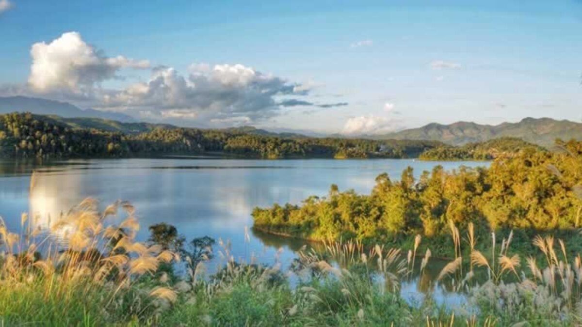
Pa Khoang Lake is located in Pa Khoang commune, City. Dien Bien Phu; About 8km from Highway 279 and from the city center. Dien Bien Phu is nearly 20km to the Northeast. In the language of the Thai people, Pa Khoang means "bamboo forest". Mr. Quang Van Viet, Chairman of the People's Committee of Pa Khoang commune, said: In the past, countless bamboo trees grew around the lake. Thai people here have a funny saying that "look up and see the sky, look down and see bamboo". Local people often use bamboo to make fishing rods and some household items. In addition to ensuring irrigation for 5,000 hectares of Muong Thanh fields with 2 rice crops, Pa Khoang lake also regulates the climate, limits the harmful effects of floods, and stores water for two hydroelectric projects: Thac Bay and Na Loi. . With the advantage of diverse vegetation, the forests around the lake are rich in all kinds of animals; Many species of plants and animals floating and under the lake bed. In 2004, on the occasion of the 50th anniversary of the Dien Bien Phu victory, the road leading to Pa Khoang Lake was paved. Also at this time, 4 motels, both luxurious and rustic, with nearly 100 rooms were opened; Cultural villages of the Thai and Kho Mu ethnic groups were also deployed with a total area of over 1,000 hectares. To get to Pa Khoang Lake, visitors can move from Highway 279 along Highway 279b into Muong Phang commune. Or you can follow the road southeast of the city. Dien Bien Phu passes through Ta Leng commune. These two routes lead visitors through winding roads along the lake, occasionally appearing behind the forest canopy on the clear blue surface of Pa Khoang Lake... Visiting Pa Khoang Lake, visitors can row a boat on the rolling waves, creep into every corner of the islands, and discover the magic of the natural world. Visitors can also walk through the forest to enjoy the scenery and visit villages of the Thai ethnic group. The people here are very friendly and hospitable; Visitors will be invited to attend cultural exchanges, enjoy art and culinary dishes, such as sticky rice, bamboo-tube rice, grilled fish, smoked meat... In winter, mist covers the lake surface, creating a magical watercolor painting. Summer comes, the lake surface is clear and gentle, reflecting the mountains, clouds, sky and dark green forests. In 2015, the Prime Minister approved the "Master plan for development of Dien Bien Phu - Pa Khoang National Tourist Area, Dien Bien province until 2020, vision to 2030". The general goal of the planning is to develop the Dien Bien Phu - Pa Khoang Tourist Area by 2020 to basically meet the criteria of the National Tourist Area; By 2030, it will truly become a National Tourism Area with a system of synchronous and modern technical facilities; is a highlight and milestone on the tourist route through the Northwest region, creating a driving force to promote tourism and socio-economic development in Dien Bien province.
Dien Bien 1777 view
From January to December
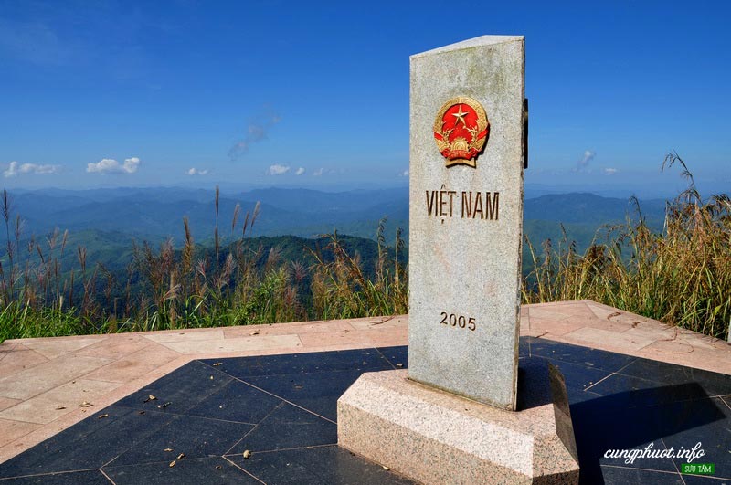
A Pa Chai is located in Sin Thau commune, Muong Nhe district, 250 km from Dien Bien Phu city, is the westernmost point of the country, where there is a landmark dividing the boundary between the three countries Vietnam - Laos - China. This is called the border junction located on the top of Khoang La San mountain, 1,864m above sea level, welcoming many tourists every year, especially young people from all over the country to visit. , conquer. Previously, A Pa Chai was considered a difficult landmark to conquer because the road to the landmark was difficult, having to cross three head-high thatched grass hills, cross forests, wade streams, and climb high mountains, which took four to five hours from The border guard station has just arrived. It's different now. In 2018, Dien Bien province completed the concrete road along the cliffs and built steps, making it easier for visitors to conquer the milestone even though they still have to walk a few kilometers of small, steep and climbing concrete roads. 500 steps to reach the landmark. The border junction marker placed on the top of the mountain is triangular in shape, with three sides facing three directions, each side has the country's name engraved in its own national language and the national emblems of the three countries of Vietnam, Laos and China. From the high point of the westernmost point of the country, looking into the distance is a vast space, majestic mountains and forests. The three-sided landmark dividing the boundary of the three countries Vietnam - Laos - China shimmers in the sunlight. Emotion and national pride surged.
Dien Bien 1747 view
From January to December
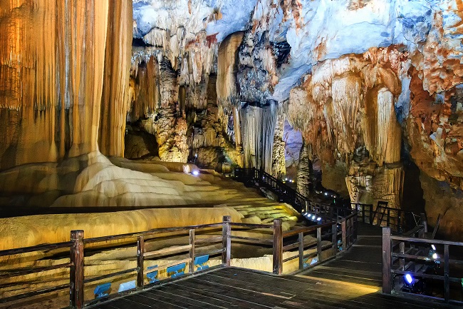
Pa Thom Cave belongs to Pa Thom commune, located in the west of Dien Bien district, bordering the Vietnam - Laos border. Local people call the cave "Tham Nang Lai" (cave of many flower fairies). The cave was discovered a long time ago along with beautiful myths and legends about couple love. Pa Thom cave scenic spot was granted a certificate of recognition as a national scenic spot by the Ministry of Culture, Sports and Tourism in 2009. At an altitude of over 1,500m above sea level, Pa Thom cave is surrounded by dense primeval forest, with rich vegetation and biodiversity. To get to the cave entrance, visitors have to walk a steep path of more than 200m long with bumpy rocks and many types of vines. Pa Thom Dien Bien Cave is located halfway up the mountain, the cave entrance is dome-shaped, 12m high, 17m wide, and the rock roof protrudes 7m. From the cave entrance, vivid shapes appear, iridescent stalactites, many with illusory colors glowing under candlelight. The cave domes are all soaring, each dome is majestic and splendid like a palace, stalactites rise high, all kinds of soft stalagmites hang down from the ceiling of the cave onto the iridescent eaves. Next to the cliff, the rocks look like large flowing waterfalls, sparkling with silver light. Continuing into the cave, visitors will encounter a giant python with a body as big as a large pot (about 20m long), with shiny skin as if it had just crawled out from the bottom of the deep cave. Going deeper, visitors will have the opportunity to see many stalactite carvings of various shapes: depictions of heaven and earth, grass and trees, animals, angels and demons..., while the carvings are affectionate. Many metaphors are endless; Everything is like a treasure trove of codes, causing visitors to stop and engrossed in looking, imagining and pondering the mysteries of heaven and earth. In addition, if you want to follow the fairy tale of earthly love, you should come and enjoy the magnificent fairyland on the path leading to the bottom of the cave: The dim room suddenly glows with a golden and silver light. when the torch is lit. The stone bed is covered with a soft mattress woven with silver stone like a silver thread, appearing behind a thin screen that can gently sway in the wind. Fairy Cave is like an unforgettable memory of endless wishes and earthly happiness. fragile. When you arrive at the cave entrance, you will see with your own eyes the cave dome over 10 m high, nearly 20 m wide, with a rock roof protruding over 5 m. Visitors will immediately encounter a giant stalactite shaped like an elephant's head. At a depth of about 20 m, there are 3 stalactites blocking the road, breaking into three sections, creating two entrances to the cave. To go through the entire cave, visitors must bring candles and flashlights and walk nearly 350 m, through 9 cave domes of different sizes. There are beautiful, shimmering natural stalactites with colorful and interesting shapes; Visitors can even hear the sound of water falling from the cave walls and stalactites... Pa Thom Cave is not just an attractive eco-tourism destination in the cave system in Dien Bien province. It also contains many good historical meanings for the nation. When you come here, you will hear about the legendary love between couples at the beginning of heaven and earth from the ethnic people here. Besides, Pa Thom Cave is a relic containing many precious values that can serve geology, minerals, archeology, botany... Scientists study tectonic processes and cycles. movement, soil and rock formation, terrain features, geomorphology and environment, soil organisms. In addition, caves are one of the attractive and interesting natural tourism resources for tourists who love to experience and explore. Pa Thom Dien Bien Cave - a cave that has both scenic value and is associated with beautiful myths and legends about couples' love, making the landscape more poetic and becoming an attractive tourist destination. This deserves to be an ideal tourist destination for tourists to visit when planning a trip to Dien Bien.
Dien Bien 1121 view
From September to December.
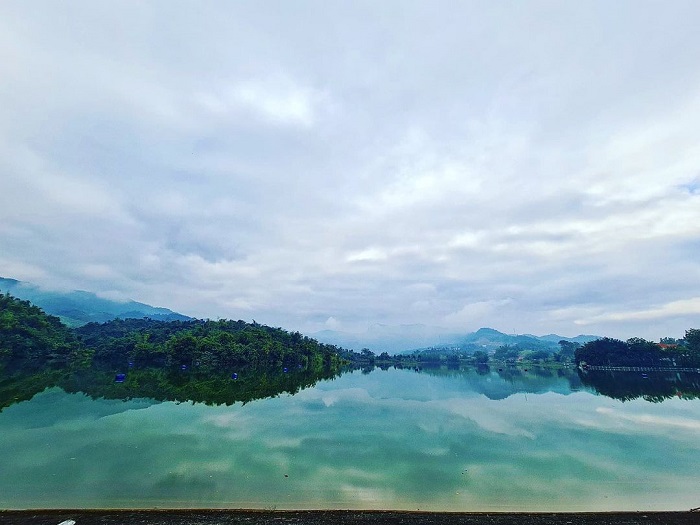
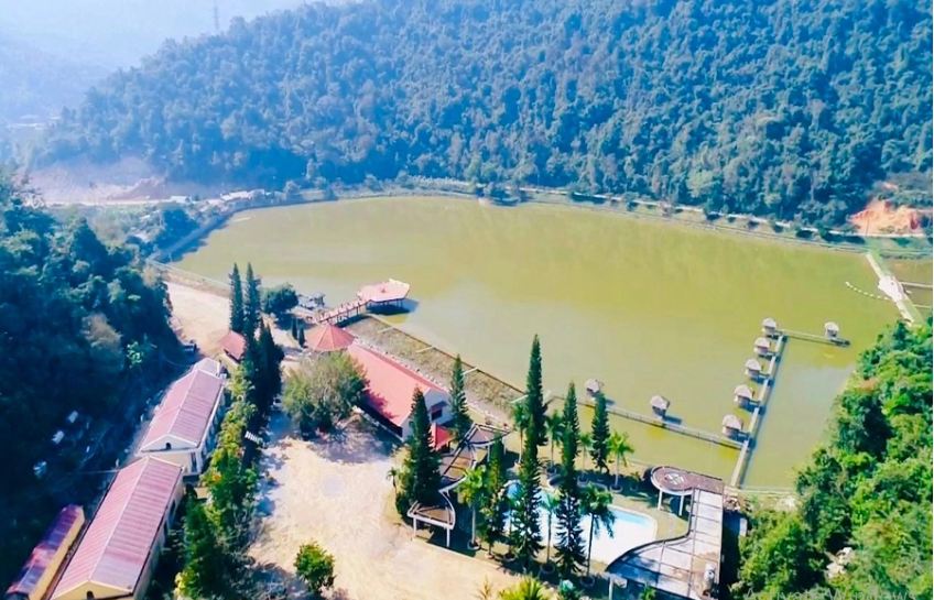
Pe Luong Lake is an artificial lake with charming natural scenery, located in the middle of the romantic Northwest mountain landscape, bringing many interesting experiences to visitors. Pe Luong Lake is a cool, clear blue lake in Thanh Luong commune, Dien Bien district, Dien Bien province. From Thanh Luong commune center to here is about 11 km, the road is quite easy and convenient for you to travel by motorbike. Therefore, this coordinates is a very interesting destination on weekends or short vacations. This is originally an artificial lake but possesses a lyrical natural landscape, located among peaceful, poetic and unique Thai villages. Tourists visiting Pe Luong Lake have the opportunity to immerse themselves in the fresh scenery, eat delicious specialties and learn more about the indigenous culture. Although this lake is a destination in Dien Bien that is still quite new to many people. But thanks to the full convergence of traffic, landscape and experience factors, more and more young people know and visit the lake. Pe Luong Lake is located in the middle of a peaceful, poetic land of Dien Bien district. This is an artificial lake project with an area of up to 25 hectares, stretching through many villages of Thai ethnic people living around the lake. If you have the opportunity to travel to Dien Bien, please visit this beautiful lake once. This lake is an artificial structure built to provide water for daily life and agricultural production of indigenous people. Besides, thanks to the beautiful and fresh scenery, this lake also has great potential for community tourism and eco-tourism. Covering this lake are lush green forests, lush and cool trees. The color of the lake's water is clear and blue, sparkling on sunny days. To visit this lake, you can drive or walk on the trails around the lake, breathing fresh, clean air. Thanks to the many trees around the lake, it is always cool and pleasant here. Pe Luong Lake has become a place for entertainment and stress relief on weekends for many tourists and local residents. This is not a professional tourist area, so anyone can come anytime they want. Coming to Pe Luong Lake, visitors have countless interesting experiences. If you just like to admire the scenery, find a clean and beautiful spot to sit and watch the lake. Or you can take a walk around the lake by motorbike or bicycle as you like. Besides, many tourists choose to explore the lake by motorboats. Here, local people prepare boats to take tourists across the lake, admire the lush green scenery on both sides of the lake and immerse themselves in the cool air. Sitting on the boat, you will feel the blue, clean and fresh water more clearly. In the distance, both sides of the lake are bright green patches that are extremely peaceful and soothing. After walking on the lake, if you have time, set up a camping tent on the lake shore and watch the calm water surface every afternoon. At night, visitors will light a campfire, organize a small barbecue party combined with singing and dancing, forgetting all the worries and troubles in life. If you belong to the team that loves to exercise, when you come to Pe Luong Lake, don't miss the opportunity to jump into the lake and immerse yourself in the cool, clear blue water. You can also bring water to paddle in the middle of the lake and experience fun water skiing. If it's quieter, you can find a small corner of a fish tree or check in some virtual live photos. Around this beautiful lake, there are about 100 Thai ethnic households living with extremely unique indigenous culture. Visitors coming here have the opportunity to enjoy delicious Thai dishes including purple sticky rice, grilled chicken, grilled fish,... extremely attractive to understand more about the culinary culture of the local people. Pe Luong Lake is a beautiful destination in Dien Bien district, promising to bring visitors truly chill and interesting experiences. In just one day, you can have fun and immerse yourself in the truly comfortable and pleasant scenery of this lake.
Dien Bien 1000 view
From April to June.
Coming to the Dien Bien travel itinerary, visitors have heard of names such as A Pa Chai, Muong Nhe, Pa Khoang Lake, Pha Din Pass,... all of which are extremely famous and attract tourists to visit. annual. But besides that, if you are looking for a new and attractive hot mineral bathing resort in the highlands of the westernmost region, don't miss the U Va hot springs area! U Va hot mineral tourist area is located in Noong Luong commune, Dien Bien district, about 17km from Dien Bien Phu city. This tourist area is a minute away from Dien Bien Phu city center, so it is very convenient, especially for tourists to visit. This road is also very easy to travel by private car, motorbike, or even passenger car. Another plus point of U Va Hot Mineral Tourist Area is that it is located in the complex of tourism resource systems of Dien Bien district such as Hoang Cong Chat temple, Pa Thom cave, Tay Trang international border gate. So visitors can completely combine U Va resort and visit famous tourist destinations of Dien Bien. Extremely convenient! U Va Hot Mineral Tourist Area was invested and built with the goal of becoming a medical resort in Dien Bien. The temperature of mineral water at U Va always reaches from 70 to 80oC, an excellent level to eliminate toxins in the body, relax tendons and bones and balance the yin and yang of the body and internal organs. Even better, at U Va Hot Mineral Tourist Area, visitors can also experience the traditional medicinal bath of the Red Dao people, which is famous for its many health benefits. Cuisine is one of the most special features in Dai Phu An. When coming here, visitors can comfortably enjoy Northwest specialties. These are: bamboo-tube rice, Ban chicken, underarm pig, Pa Phit Top, kitchen buffalo meat... Uva Hot Mineral Tourist Area only uses ingredients to prepare clean dishes with clear origins. This not only makes the dish delicious and fresh, but also ensures food hygiene and safety. Especially for large groups of people coming to the U Va hot mineral tourist area, visitors can prepare their favorite dishes themselves if desired, this brings a very interesting experience during the trip. vacation time in U Va. Uva Hot Mineral Tourist Area is surrounded by high mountains with many precious trees, in front is a large lake creating a majestic and poetic landscape, while also making the air in U Va always fresh and cool. suitable for relaxation. In particular, visitors to U Va during the lotus blooming season will be able to admire a vast lotus lake with lotus flowers blooming in the gentle breeze. The fragile, gentle beauty and pleasant fragrance will make visitors feel pure and relaxed. U Va Hot Mineral Tourist Area has 2 types of rooms. Visitors can comfortably choose to stay in modern houses or stay in stilt houses with Thai ethnic style. Not only does it have a variety of room types with flexible capacity, U Va Hot Mineral Tourist Area also has a swimming pool for both adults and children, an event restaurant with a capacity of hundreds of people and modern equipment. to serve the entertainment and entertainment needs of tourists. The best time for tourists to take a vacation to Uva Hot Springs is from November to April every year! In particular, if you want to soak in hot minerals, you should soak in the early morning or in the afternoon. It is the difference, the dedicated and professional service attitude... that makes U Va Hot Mineral Resort a favorite stop for many people. If you have the opportunity to travel to Dien Bien, you should stop here to feel it!
Dien Bien 961 view
From November to April of the following year
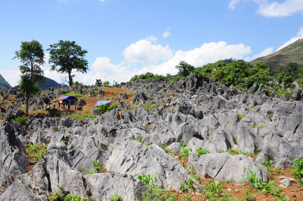
Tua Chua Stone Plateau is a special destination of Dien Bien province, known as "little Ha Giang" in a remote, desolate land. Tua Chua Stone Plateau is a limestone mountain area in Tua Chua district, about 130 km from Dien Bien Phu city center. To get here, visitors need to travel 130 km to the Northeast. This entire plateau is located in the communes of Sinh Phinh, Ta Phin, Ta Sin Thang, Sin Chai, Tua Chua district. Those who have traveled to Ha Giang and then returned to Tua Chua district all commented that this place has beautiful scenery like the Dong Van stone plateau. The journey here is full of hardships when visitors have to go through steep winding passes, treacherous mountain roads and even deep abysses. This land is the residence of the Mong people. They live on rocks, in harmony with the unique and different natural picture. Coming here, you will truly feel the impressive landscape of the rocky plateau, learn about the culture rich in national identity. Surely you will have many special memories when traveling here. Tua Chua Stone Plateau is located at an altitude of 1400 meters above sea level, gifted by Mother Nature with extremely special terrain. Up to 70% of the district's area is limestone mountains. So coming here, you will get lost in a space full of rocks. The higher you move, the more desolate and wild the scenery appears. First-time visitors to Dien Bien share that coming to this rocky plateau feels like entering another world. There, black rocks are nestled into the cliffs, covering the ground and covering the simple houses of the Mong ethnic people living here. Exploring the Tua Chua stone plateau, the best thing is driving a motorbike on the roads. The curved bends lead deep into a "stone forest" that is both mysterious, magical, and irresistibly beautiful. On the way, you will see the wooden stilt houses of the Mong people built on rocks. They live in a land where all sides are covered with rocks. The scenery in Tua Chua karst plateau is really similar to the Dong Van karst plateau global geopark. If you choose any location to take photos, you will have difficulty distinguishing which is Tua Chua and which is Dong Van. However, in reality, this place also has many differences that visitors must come here to explore to fully feel. Tua Chua district not only attracts tourists because of its pristine and wild nature, but is also a place that photography enthusiasts love. Here, you will be able to save beautiful moments with images of limestone mountains of all shapes and sizes. There are patches of cat-ear rocks stacked on ramparts, and places where the rocks are as sharp as skyscrapers, enchanting visitors. Exploring this destination in Dien Bien, in addition to admiring a unique stone plateau, visitors also have the opportunity to learn more about the life and activities of the Mong people here. It seems that in this place filled with only rocks, there is nothing that can be done, but the Mong people know how to take advantage of pouring soil into the rock holes to grow vegetables, grass and fruit trees. In small, flat valleys without rocks, indigenous people also take advantage of growing rice to increase the source of agricultural products to serve their lives. Looking at the way the Mong people take advantage of every inch of land to cultivate, we can truly admire their spirit of overcoming difficulties. On the Tua Chua rock plateau, visitors also have the opportunity to explore caves deep in the rocks. Among them, Tham Khen cave in Na Xa village, Muong Dun commune is visited by many tourists. Entering this cave, you will admire the stalactites in yellow, blue, gray with all kinds of images such as chandeliers, rice bundles, banyan trees, terraced fields... very special. Tua Chua Stone Plateau is located in a remote area of Dien Bien province, possessing extremely unique and impressive beauty. This place is inherently a poor district of the province so tourism has not been developed. There aren't many services here, so it's best to explore and return during the day, avoid staying overnight. Any season of the year is suitable for tourists to visit Tua Chua, but spring is the most beautiful. Coming here in the first days of the year, you will see cherry blossoms blooming brightly, see bright red rice flowers on the roads and enjoy the fresh, cool and pleasant air of this place. Tua Chua Stone Plateau is one of the tourist destinations worth exploring in Dien Bien. This place opens up a unique picture for visitors to have the most memorable travel experiences when visiting the historical land called Dien Bien.
Dien Bien 972 view
From January to March.
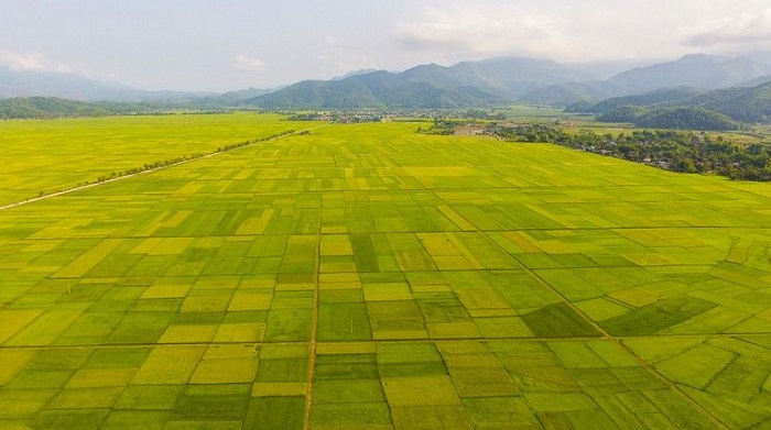
Muong Thanh field, the largest in the Northwest, is the famous rice granary of the North of our country, possessing immense beauty and bringing many interesting travel experiences to tourists. Muong Thanh field is the largest rice field in the Northwest region, larger than Muong Lo, Muong Than and Muong Tac. This place is the rich rice granary of Dien Bien province, covering more than 140 square kilometers and located at an altitude of more than 400 meters above sea level. This field stretches about 20 km long and about 6 km wide. If you have the opportunity to travel to Dien Bien, you must definitely stop at Muong Thanh to admire a vast valley spreading from Nghia Lo to Dien Bien, passing through 12 Thanh Minh communes, Dien Bien town, Thanh Xuong respectively. , Thanh An, Noong Het, Sam Mun, Noong Luong, Thanh Yen, Thanh Chan, Thanh Hung, Thanh Luong and Thanh Nua. Muong Thanh field is surrounded by Nam Rom stream and rolling high mountains, creating a charming and beautiful landscape painting. In addition to its agricultural significance, this vast rice field also contributes to the development of local tourism. This place has become a very attractive destination in Dien Bien for the province. Visiting Muong Thanh Dien Bien field, visitors will be overwhelmed by a scene that is so beautiful, majestic, magnificent but also very peaceful. Only by coming here directly and seeing the vast rice fields and rolling hills in the distance can you fully feel the beauty of this land. Visitors have many directions to approach this vast rice field. However, no matter which way you go, you will see a beautiful and charming Muong Thanh. The most beautiful thing is when looking at the rice fields from above, through the image of the flycam. All the consecutive fields and winding roads create an extremely unique and impressive scene. Muong Thanh fields are beautiful in any season, but their peak beauty is in September when the green fields begin to turn a beautiful bright yellow. This place has a valley terrain so there are no terraced fields like Hoang Su Phi or Mu Cang Chai. However, that does not make this rice field less beautiful. In the ripe rice season, Muong Thanh is like a giant cloak with eye-catching bright yellow colors. Surrounding the rice fields are mountains and green forests, creating a very satisfying scene. Any corner of the rice field is a beautiful background for visitors to stand in and take photos. If you are a travel enthusiast and have all the equipment such as flycam, drone,... you definitely have to take many beautiful photos from above to fully enjoy the beauty of this largest rice field in the Northwest. . A bright yellow color scheme, a very peaceful scene makes you love the beauty of Vietnam's homeland even more. Coming to Muong Thanh fields, visitors will have many memorable activities such as exploring the beautiful scenery of the ripe rice season in September and October. You can spend time walking around the golden rice fields, inhaling the fragrant rice smell. in the sun or freely hunt for beautiful virtual photos. In addition to the experience of sightseeing, walking or taking photos, coming to Muong Thanh is also an opportunity for you to understand more about the heroic history of Dien Bien land. This is where the famous 1954 Dien Bien Phu campaign took place. Among them, the Muong Thanh basin is a base with important significance in the fight. In particular, when you return to Muong Thanh fields, you will also enjoy delicious meals cooked from a very special type of Muong Thanh rice. This type of rice is small, short grain and has a unique aroma. When cooked, rice will have a rich, sweet taste and a very beautiful white color. With Muong Thanh rice, people can also make traditional dishes such as sticky rice used at weddings and engagements. Besides exploring Muong Thanh, tourists traveling to Dien Bien can also spend time visiting Khau Ty hill, Pa Khoang lake, Muong Phang... all are beautiful destinations in Dien Bien, giving visitors unique experiences. Diverse and interesting travel to be more proud of your homeland and country. Today, Muong Thanh fields and many other rice fields in the Northwest region contribute to the strong development of Vietnamese tourism, especially in the fall when rice ripens. During your trip around Vietnam, remember to visit these rice fields to save yourself many valuable youthful experiences.
Dien Bien 892 view
From September to October.
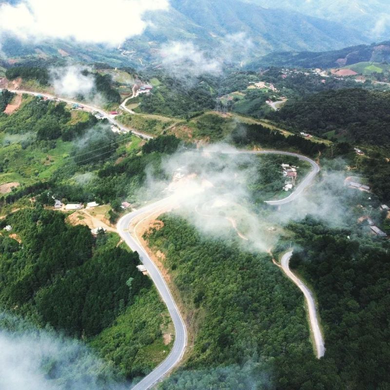
Nearly 100 km from Dien Bien Phu city, Dien Bien province, Pha Din Pass is the boundary between Son La and Dien Bien provinces. The name Pha Din Pass comes from the Thai word "Pha Din" in which "Pha" means "Heaven", "Din" means "Earth", meaning this is the junction between heaven and earth. The pass is 32km long and is located on Highway 6, part of it in Phong Lai commune, Thuan Chau district, Son La province and part of it in Toa Tinh commune, Tuan Giao district, Dien Bien province. The starting point of the pass is 66km west of Son La town, while the end point of the pass is about 84km from Dien Bien city. At Pha Din slope, she carried the burden. Lung Lo Pass, brother and sister sing. Even though bombs and bullets shatter bones and flesh. Don't get discouraged, don't regret your youth. The optimistic poem sketches the spirit of a fiery time 65 years ago. Pha Din Pass has an altitude of over 1,000m above sea level, the terrain is very dangerous with one side being a steep cliff, the other side being a deep abyss "a thousand meters up, a thousand meters down". During the Dien Bien Phu campaign in 1954, Pha Din Pass was one of the important arterial routes transporting weapons, ammunition and food to the front and it became a symbol of bravery for more than 8,000 young people volunteered to "Determine to die for the country." In order to block the Viet Minh's reinforcement line into Dien Bien Phu, for 48 days and nights, General De Castries sent planes to hijack Route 6, in which Pha Din Pass was one of the points that suffered the most bombs and bullets. At the top of the pass there is still a stele recording this historical mark. On the stele, it is written: "This is the place that suffered the most from air bombardments by the French colonialists to block our supply of weapons, ammunition, food, and food to serve the Dien Bien Phu campaign." ". By 2005, the government decided to invest in upgrading National Highway 6 to the Northwest. The new Pha Din Pass was built along the mountainside on the left side of old Highway 6, 26km long. The new pass route has been put into use to help vehicles circulate more safely. The old pass route is now for indigenous people or adventurous tourists to conquer and explore. Source: Dien Bien Province Monuments Management Board
Dien Bien 2133 view
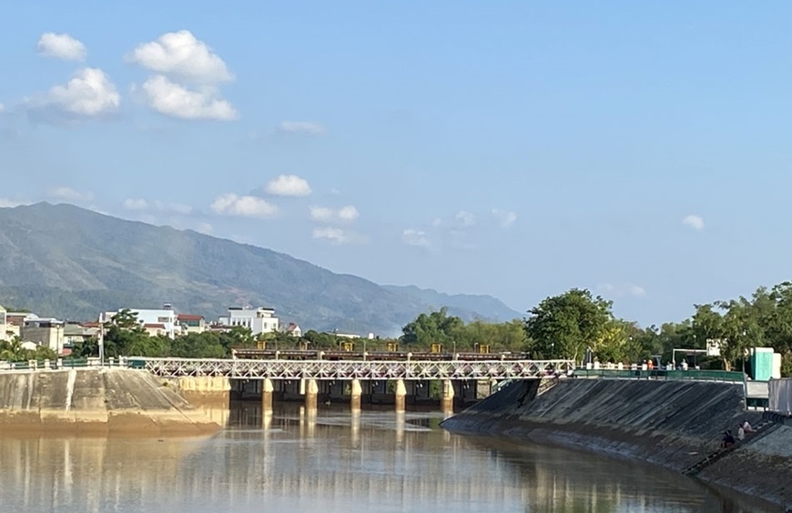
Muong Thanh Bridge, also known as "Prenley" bridge by the French military, is a bridge across the Nam Rom River, built by the French. The bridge is a military project located in the central subdivision of the Dien Bien Phu base group. On November 20, 1953, the French Colonialists chose Dien Bien Phu to build the strongest stronghold group in Indochina at that time with 49 strongholds divided into 3 subdivisions: Northern Division, Southern Division, also known as is the Hong Cum subdivision and the Central subdivision is the most important subdivision. Because the terrain of Dien Bien Phu is a wide basin, surrounded by high mountains, in the central battlefield there is the Nam Rom river flowing through dividing the central area into left and right banks, so the Communication from the central command post with the base groups on the eastern and northeastern hills encountered many difficulties. To solve those difficulties, the French army built Muong Thanh bridge across Nam Rom river. Muong Thanh iron bridge is a pre-made bridge that was shipped from France and assembled in Dien Bien. The entire bridge is 40 m long and 5 m wide. On both sides of the bridge are simple supporting iron bars, without a middle shaft. The bridge floor is paved with wood, and underneath are iron beams that are very firmly linked together to ensure a load of 8-15 tons. To protect this vital bridge, the French arranged bases 509, 508 and 507 on the eastern bridgehead, while on the western bridgehead they arranged a 4-barrel machine gun nest to prevent the enemy from attacking beyond. Cross the bridge to attack the central command post. With such a force arrangement, General De Cat hoped to maintain the bridge and maintain the gateway for reinforcements to the eastern and northeastern peak clusters of the Dien Bien Phu stronghold group. When war has not yet occurred, Muong Thanh bridge is a transport route for raw materials, ammunition, and barbed wire to serve the construction of defensive bases in the East and the Northern subdivision. During the general attack to destroy all the eastern heights at 4:00 a.m. on May 7, 1954, our troops destroyed the entire A1 base. At 2:00 p.m., Regiment 209, Division 312 launched an attack. Base 597 at the beginning of Muong Thanh bridge. The enemy at base 507 raised the white flag to surrender, took advantage of the victory, and rushed forward. Group 312 attacked and destroyed two bases 508 and 509 on the left bank of the Nam Rom river. At these two bases, the enemy resisted weakly and was quickly defeated. extermination. From the east, Regiment 209 advanced straight into the central area of Muong Thanh with Regiment 98 and Regiment 174 close to the central area. In the west, the 36th Regiment entered the last strongholds covering the enemy's headquarters. The 88th Regiment opened the way through the airport and straight into Gono's last lair. Wherever our troops fought, the enemy's white flag appeared, many enemy groups from bases and trenches flocked out to surrender their weapons. At exactly 5:30 p.m. on May 7, 1954, our army's Decisive War - Determined Victory flag fluttered on the roof of General De Cat's bunker, successfully ending the historic Dien Bien Phu campaign. This was the biggest victory in the long resistance war against the French colonialists and American interventionists, and also the most famous victory in the history of the Vietnamese people against foreign invaders. Initially, Muong Thanh bridge was built by the French after parachuting to occupy Dien Bien Phu. In the end, the bridge became a means of guiding the way for our soldiers to attack, planting the Decisive Victory flag on the roof of the bunker of defeated General De Cat. Source: Compiled by Department of Culture, Sports and Tourism of Dien Bien province
Dien Bien 1956 view
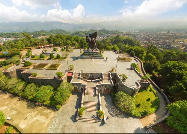
Hill D belongs to the Dominique cluster, the French colonialists built and turned this base into the frontline position of the eastern hills. Because the location of Hill D was to shield and protect the Dien Bien Phu Fortress Group Command Headquarters and Muong Thanh Airport, the French colonialists took advantage of the natural terrain to benefit them militarily to build the position. The defense position is extremely solid and powerful. Here, the French army arranged the very battle-hardened 3rd Battalion of the Algerian Regiment to occupy it. As for the Vietnam People's Army, capturing the Eastern peak range, including peak D1, is a very important task in the second attack of the Dien Bien Phu campaign. The unit responsible for destroying D1 base is Battalions 166 and 154 of Regiment 209, Group 312. At exactly 5:00 p.m. on March 30, 1954, artillery guns of the Vietnamese army simultaneously rained down on hill D1 and the eastern high points in the central area of Muong Thanh. Within 30 minutes, the 209th regiment captured D1 hill. The next morning, the French army counterattacked in conjunction with the air force to recapture the base. The battle took place fiercely after 2 days of complete control by the Vietnamese army. D1 hill base. After capturing hill cluster D, Vietnamese soldiers turned this place into a battlefield for the 209th Regiment's firepower, continuing to support other units to capture the remaining French bases. It can be said that the battle that took place on the eastern hills, including D1, was one of the important battles that contributed to the victory in the second attack of the Dien Bien Phu campaign. On the historic land of Dien Bien today, there are a number of monuments and bas-reliefs built to fully, realistically and vividly recreate the great battle of our army and people more than a few years ago. 6 decades, in which the Dien Bien Phu Victory Monument is the largest and only bronze monument in the project of works celebrating the 50th anniversary of the historic victory of Dien Bien Phu. Hill D1 relic was honored to be chosen as the location for the Dien Bien Phu Victory Monument, because the relic is located in the center of the city, has a beautiful terrain, from the relic you can observe the entire Dien Bien basin. Bien Phu. This was the tallest, largest and heaviest bronze statue cluster in Vietnam at that time. The statue was built with a height of 12.6m, mounted on a 3.6m high pedestal and cast with 217 tons of bronze. The Dien Bien Phu Victory Monument stands tall in the midst of historical Dien Bien and together with other relics such as: Hill A1, Muong Thanh bridge, Him Lam, Doc Lap, Ban Keo, Muong Phang.... has become The place is eternal with the country, a testament to the heroic history of the Vietnamese people in the thousands of years of struggle to build and defend the country; creating national identity, passing on heritage to future generations; Strengthen solidarity and attachment between generations of Vietnamese people and among ethnic groups in the area; It is one of the typical symbols for the desire for peace, friendliness, hospitality, always open to welcome friends and international tourists, and the spirit of cooperation and development towards the future. Source: Department of Culture, Sports and Tourism of Dien Bien province
Dien Bien 1902 view
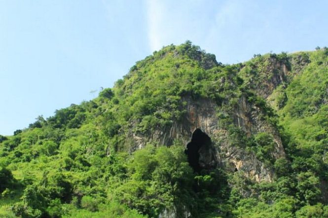
Tham Pua Cave is located at the foot of Pu Hong Cay limestone mountain in Ban Po area, Chieng Sinh commune, Tuan Giao district, Dien Bien province. Dien Bien Museum in conjunction with the Department of Culture, Information and Sports of Tuan Giao district inspected and surveyed Tham Pua cave and collected more than 100 relics including pebble work tools; rough almond-shaped chopping tool with rough chisel on one end; Labor tools made of stream snail shells and traces of charcoal and ash. The archaeological relics discovered in Tham Pua cave have many points very similar to the relics unearthed in Tham Khuong cave and the rocky mountains with Tham Pua cave. All of these artifacts have great historical significance, proving that this is the place of residence of ancient Vietnamese people since ancient times and this land is always associated with the history of existence and development as well as the history of Vietnam. The history of the struggle to build and defend the country of the Vietnamese people. That's why Tham Pua cave is truly a historical and cultural relic of immense value in Dien Bien. During the resistance war against the French colonialists, Tham Pua cave was chosen as the location for the first Command Post of the Tran Dinh Campaign (alias of the Dien Bien Phu Campaign) led by General Vo Nguyen Giap as Commander-in-Chief. (from December 17, 1953 to January 17, 1954). Here, from the early days of January 1954, combat orders were disseminated on a large sand table. The location of Tham Pua cave was chosen as the Command Post with a safe terrain. Next to the cave is a flat land, more than 10 hectares wide, convenient for directing campaigns in mountainous areas. Near the day of opening fire to attack the Dien Bien Phu stronghold group, the command post from Tham Pua cave was moved to Huoi He cave at km 62 near Na Tau village. Tham Pua Cave, the location of the first Command Post in Chieng Sinh, Tuan Giao and Huoi He Cave in Na Tau, Dien Bien District, where an important moment was witnessed in the decision to change the motto "fight quickly". "Quick victory" became the motto "Strong fight, steady advance" of the Dien Bien Phu Campaign Command, headed by General Commander Vo Nguyen Giap, which has become one of the prominent relics of the battlefield relics cluster. Dien Bien Phu. Source: Dien Bien Phu Historical Victory Museum
Dien Bien 1886 view
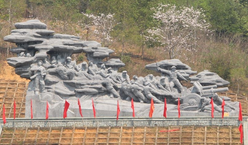
The artillery track relic is located in Na Nhan commune, Dien Bien district, Dien Bien province, located along Highway 279 on the right bank of Nam Rom river in the direction from Tuan Giao to Dien Bien. This place marked the change in the combat motto of the Front Command from "fight quickly, win quickly" to the motto "fight firmly and advance firmly". And this is also a historical place imprinted with sacrifices, difficulties and hardships as well as solidarity and synergy during the preparation of the campaign, the spirit of determination to overcome all challenges and hardships to win. On January 14, 1954, at the Campaign Command Headquarters in Tham Pua Cave, Km 15, Tuan Giao - Dien Bien Street, the Party Committee and the Campaign Command met to discuss a plan to destroy the Dien Bien Phu stronghold group. The Politburo's strategic determination at the meeting was to concentrate forces to destroy all enemy troops in Dien Bien Phu according to the principle of "sure victory". The artillery towing command was established with comrade Le Trong Tan as commander and let each type of gun be tested to learn from experience and decided to use a truck to tow the artillery at kilometer 9 near Na Nhan village and stop cutting. The artillery got out of the vehicle and used human power to pull dozens of 3-ton artillery pieces into battlefields over a distance of 15km. The artillery road is 3m wide, running from the mouth of Na Nhan forest through the 1150m high Pu Pha Song peak, equivalent to a 40 - 60 degree slope down to Ban Tau, Dien Bien Phu - Lai Chau road to Nghiu village. To ensure secrecy, the artillery path must be completely camouflaged to prevent detection by reconnaissance aircraft. The estimated road construction time was one day and one night. The soldiers of the 308th Army, a company of mountain artillery, and an engineering battalion of more than 5,000 people successfully completed the road to pull the artillery in 20 hours. The next thing is to put howitzers and anti-aircraft guns into the battlefield position to fire. The mission was given to Group 351 and Group 312, expected to be completed in 3 nights. But after 7 arduous days and nights, our artillery still did not reach all the battlefields compared to the original plan, so the planned shooting time of January 20, 1954 had to be postponed for 5 days, i.e. January 25, 1954. At this time, our Command Post moved from Tham Pua cave to Huoi He cave, Na Tau village. Here, after considering the many changes in the enemy's situation, in order to ensure "a sure victory", General Vo Nguyen Giap quickly changed the battle plan from "quick attack, quick victory" to "sure victory, sure advance." ”, ordered the artillery to be pulled out of the battlefield, retreated to the gathering place, and re-prepared. Pulling artillery into the battlefield is difficult and difficult, pulling artillery out is even more difficult. Our artillery path has now been exposed, the road is slippery, enemy planes are searching day and night to bomb. On open roads, artillery transfer must be carried out at night. At night, on the roads pulling artillery, the soldiers' backs were drenched in sweat, their eyes were dark from lack of sleep, their hands were tightly clinging to the winch rope, their feet were as if they were stuck to the ground, gritting their teeth to hold the artillery. Also in this situation, the song "Ho pulled up artillery" by musician Hoang Van was born. The song immediately became widely popular among front office units, taking to the streets to sing artillery to serve the soldiers. . Up to now, the comedy song "Ho pulling the firecrackers" has become an immortal epic about one of the heroic historical periods of our nation. After 11 arduous days and nights, all of our artillery was gathered to a safe area. In 2004, on the occasion of the 50th anniversary of the historic victory of Dien Bien Phu, our Party and State provided funding to build, restore and embellish the road to pull artillery by hand. Source: Dien Bien Phu Historical Victory Museum
Dien Bien 1773 view
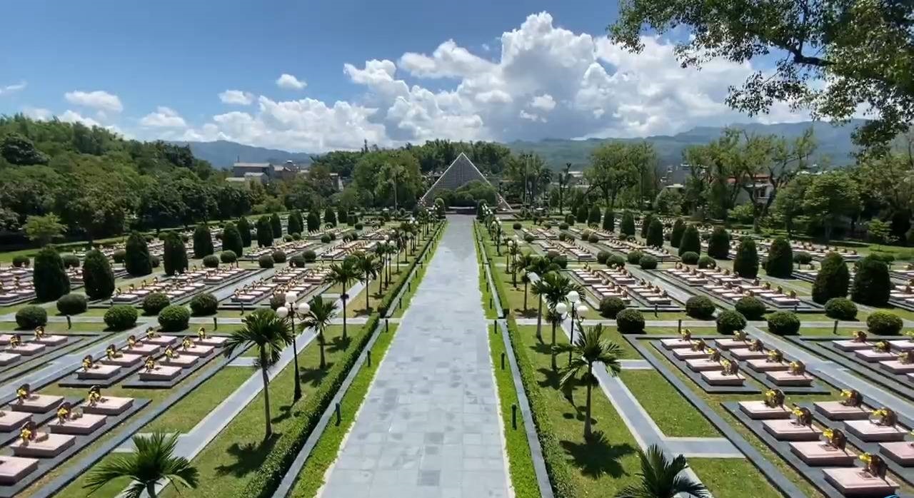
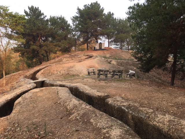
Hill A1 is located in Muong Thanh ward, Dien Bien Phu city, Dien Bien province, and is the most important base in the group of French colonial bases in Dien Bien Phu. Hill A1 is where the historic battle that lasted 39 days and nights between our troops and the enemy took place, contributing to the famous Dien Bien Phu victory in five continents, shaking the earth. A1 is the symbol that the Vietnamese army gave to the hill, while the French army called it Eliane 2. Due to its particularly important position, the French army built A1 to become the strongest resistance in Dien Bien Phu. With an extremely solid secret underground bunker system, strong firepower arrangements, machine gun nests, and battlements so that one defending soldier can fight off many attacking soldiers at the same time. At the same time, France continuously reinforced its strongest forces and provided maximum firepower support to protect this base to the end. Therefore, in the first attack, the 174th Regiment of the Vietnam People's Army launched four consecutive attacks but only captured half of the hill. It was not until dawn on May 7, 1954, thanks to a 1-ton explosive block secretly dug to destroy the underground tunnel system, that the Vietnam People's Army was able to complete the occupation of Hill A1. This was the most fierce battle in the entire Dien Bien Phu campaign, with the highest number of soldiers and casualties. Currently, on the Northwest peak of Hill A1, there is a monument commemorating the soldiers and martyrs who sacrificed their lives, built in the "Three Mountains" style, high in the middle, low on both sides and both shaped like a leader's roof. In front is an incense burner, in the middle is a stele, the National Flag insignia, a yellow star with a red circular background, surrounded by a wreath of flowers. Next to the monument is the body of one of two 18-ton tanks that Quan Ba Hecvuê brought from the center of Muong Thanh to counterattack the Vietnamese army. Another important relic is a funnel-shaped hole as big as a shallow "pavilion pond". That is a trace of our army's thousand-pound explosion, which our soldiers often call "digging a tunnel to conquer a tunnel", conquering both the enemy's bunkers and bunkers. Located not far south of the historical site Hill A1 is Hill A1 National Martyrs Cemetery built in 1958. This is the resting place of 644 military officers and soldiers who heroically sacrificed their lives to protect the country during the Dien Bien Phu campaign. In 1994, the cemetery was renovated, planned and built into a historical and cultural project, a park cemetery with many items. Inside the campus is the manor house designed in the style of a typical stilt house of the Thai Dien Bien people, the outside ceremony platform is designed in the Khue Van Cac style, on both sides are two types of ancient city walls with two moats in front. 6m wide, outside the city wall is a bas-relief depicting the heroic fight of our army and people and the nine years of long resistance to regain national independence. Source: Dien Bien province electronic information portal
Dien Bien 1752 view
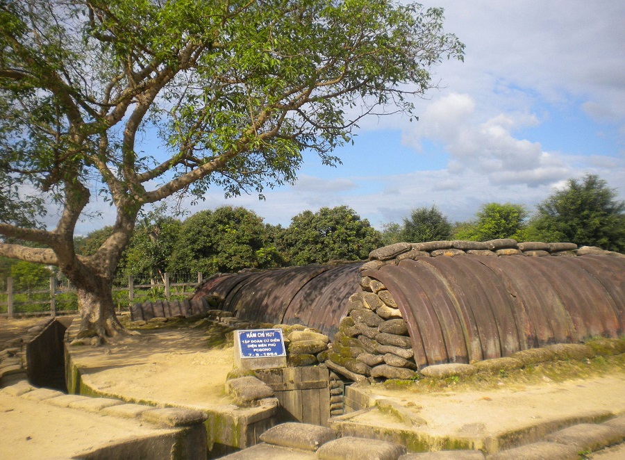
Ham Do Castries (local people's name) full name is Dien Bien Phu stronghold group command post, also known as GoNo command post, located in Thanh Truong ward - Dien Bien Phu city - Dien Bien province. . During the Dien Bien Phu campaign, GoNo Command Post was located in the center of the stronghold group, 2m underground and in a lower position than the direction of our army's attack. This is the headquarters of a giant military group that France and the US are very proud to consider the strongest fortress ever in Indochina. GoNo command post is given priority to have solid and solid construction materials capable of resisting enemy firepower, in addition to being protected by all the most modern weapons and means of warfare at the time. then. The structure and arrangement of the basement are still kept intact with a length of 20m and a width of 8m divided into 4 compartments used for both work and accommodation. Surrounding the bunker is a barbed wire fence with alternating mines and 4 defensive tanks in 4 directions. In this basement, De Castries solemnly welcomed many high-ranking officials from England, France, America and dozens of writers and journalists from the Western journalism industry. It was also here that De Castries and his entire General Staff plotted to destroy our main army, but he also had to go crazy many times to deal with enemy attacks. Vietnam People's Army. At 3:00 p.m. on May 7, 1954, our campaign command ordered a general attack on the entire front to destroy the entire group of Dien Bien Phu strongholds. After destroying key strongholds around the central division, our troops crossed Muong Thanh bridge and headed straight to Gono Command. At 5:30 p.m., comrade Ta Quoc Luat, commander of company 360, regiment 209, regiment 312, and 2 assault soldiers captured General De Castries and the entire French command, holding the flag "Determined battle, Quyet". Victory" flew high above the tunnel roof in the middle of the historic summer afternoon of May, signaling the day of complete victory for our army and people. Today, the Ham Do Castries relic along with other relics in the Dien Bien Phu historical relic complex have been invested in by the Party and State to restore and renovate to serve domestic and foreign visitors. Part of promoting the value of the Dien Bien Phu historical victory relic site and also to propagate and educate the heroic Dien Bien Phu tradition. Source: Department of Culture, Sports and Tourism of Dien Bien province
Dien Bien 1748 view
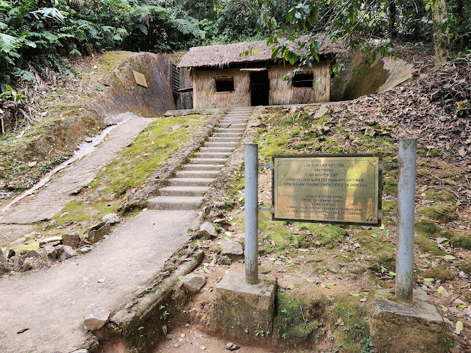
Dien Bien Phu campaign headquarters is hidden in the old forest at the foot of Pu Don mountain in Muong Phang commune, Dien Bien district, nearly 40 km from Dien Bien Phu city. This is where General Vo Nguyen Giap often worked and rested during the Dien Bien Phu campaign, which achieved a "famous victory on five continents, shaking the earth". The Dien Bien Phu campaign command area was stationed in Muong Phang for 105 days from January 31, 1954 to May 15, 1954. With the arrangement of tunnels and camps into a continuous system, hidden in the jungle at the foot of Pu Don mountain, the important headquarters of the Dien Bien Phu campaign was guaranteed absolute safety... From this Command Post, going higher, standing on the highest point, you can observe the entire city of Dien Bien Phu, Muong Thanh valley and former strongholds of the French army such as Him Lam hill and Doc Lap hill. , D1 hill, C1 hill, A1 hill... The telephone switchboard tunnel helps the Campaign Command communicate with the infantry, engineering, artillery, and antiaircraft units at the front and the warehouse units, stations of the General Department of Supply, military medical system, The civilian fire line is behind the front. This is a direct communication network between the Campaign Command and the Party Central Politburo, Uncle Ho... From the tunnel through the mountain, connecting from General Vo Nguyen Giap's shack to Major General Hoang Van Thai's shack, to other locations such as the workplace of the Chinese military advisory group, the workplace of the Chief of Information Department. Hoang Dao Thuy campaign... all still seem to have intact traces of history... Next to the General's working and resting place is a shelter dug through the mountain. When the French army bombed heavily, the General worked and rested in this shelter. From the shack of General Vo Nguyen Giap to the shack of Chief of Staff Hoang Van Thai and the shack of military advisor Vi Quoc Thanh is a 69m long tunnel. The tunnel is 1.70m high, 1 to 3m wide, in the middle of the tunnel there is a meeting room with an area of 18m2 and 5 communication locations. Located 300m northeast of the Campaign Headquarters is where our army and people solemnly held a military parade to celebrate victory on May 13, 1954. In the Project to renovate the Dien Bien Phu Campaign Command Headquarters Relics, the Dien Bien Phu Relics Project Management Board implemented General Vo Nguyen Giap's idea of planning a campus on the old military parade grounds and placing a cluster of monuments commemorating the 55th anniversary of the victory of Dien Bien Phu. Along with the Dien Bien Phu Campaign Command Relics, the Victory Monument cluster at Muong Phang Park is also a stop not to be missed when coming to the Dien Bien Phu Campaign Command Relics. Local people often call this place by the familiar name "Memorial Monument". Source: Dien Bien Province Radio and Television Station
Dien Bien 1703 view
Him Lam is one of the outer locations of the Dien Bien Phu stronghold group, located on Road 41 (now Road 279) next to a small village, the gateway to the Northeast, blocking the road from Tuan Giao to Dien Bien. , one of the strongest resistance centers of the Dien Bien Phu stronghold group. The French colonialists chose to build a defense system here located on 3 hills at a height of nearly 500m with 3 bases in the form of a tripod, supporting each other, with a solid defensive position and lots of powerful firepower. There is also a system of secondary fortifications made of dense barbed wire fences, in addition to being equipped with guns with infrared rays to detect targets at night, tanks, artillery, and air force. Him Lam was identified by our Front Command as the opening battle. To ensure the principle of "the first battle must be won", our troops arranged strong forces, including backup plans; plans for artillery defense, air defense, prevent enemy counterattacks, anticipate basic situations and how to handle them during the course of combat. The task of destroying the Him Lam Resistance Center was assigned to the 312th Battalion. Before we opened fire, all doubts about the defensive capabilities of the Dien Bien Phu stronghold group were extinguished. The French colonialists completely knew in advance the time and plan to attack the Him Lam resistance center of the Vietnam People's Army and had the most optimal preparations. French artillery was also ready and waiting for the opportunity to extinguish any movements that could cause aggression against the base group. But the element of surprise is something they cannot predict. The presence of our heavy artillery on the hillsides surrounding the basin and the construction of perfect camouflaged battlefields brought an unbelievable surprise to the French, for which they had to pay the price with a near collapse. almost completely of the Him Lam stronghold cluster right in the first hours of the campaign. Also in this battle, we witnessed the heroic sacrifice of Mr. Phan Dinh Giot, who used his body to cover the enemy's fire points, creating an opportunity for his comrades to advance and occupy the remaining positions. Along with Be Van Dan, To Vinh Dien and Tran Can, these four heroes stand out for the spirit of "Determining to die for the country and deciding to live" and become examples and immortal names in history books, associated with the war. later won Dien Bien Phu. The rapid fall of the Him Lam Resistance Center caused deep mental panic to not only the soldiers but also high-ranking figures of the Dien Bien Phu stronghold group. Immediately after Him Lam, Doc Lap and Ban Keo were also quickly destroyed and forced to surrender; We have opened the northern and northeastern gates of the Dien Bien Phu stronghold group, continuing to take the next steps towards another important goal, the center of Muong Thanh, gradually destroying the extremely strong stronghold group. This strong. Him Lam resistance center is a component relic of the ancient Dien Bien Phu battlefield relic site. Source: Department of Culture, Sports and Tourism of Dien Bien province
Dien Bien 1692 view
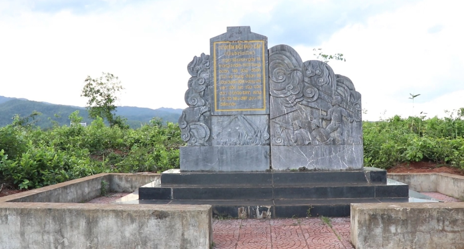
Independence Hill is a component relic of the Dien Bien Phu Battlefield Special National Monument. Doc Lap Hill has another name: Pu Vang (Victory Hill). Located right at the foot of Pu Vang is Tong Khao field, a sunken field. In the past, the Phe invaders captured all the children in the area and killed them. Children who are still infants are put in a mortar and pounded. Children who are toddlers or older are thrown into this low field and then drained to die. When the field dried up, children's bones were white all over the field, from then on this field was called Tong Khao (local language meaning field of white bones). At Tong Khao field, according to local people, there are also traces of the victory of the insurgent leader Hoang Cong Chat who came from the lowlands to wave the insurrection flag. The leader was assisted by the Thai ethnic people, typically General Ngai and General Khanh, in the fight against Phe enemy general Pha Chau Tin Toong in Tam Van citadel. The insurgents chased the Phe invaders up to the foot of the hill and destroyed all the enemy troops, beheading the enemy general in 1754. During the 1954 Dien Bien Phu campaign, the French Army named this base Gabrielle. Doc Lap is the name given to this base by the People's Army of Vietnam because the hill stands separately in the middle of a flat area in the north of Muong Thanh field. On November 20, 1953, French troops parachuted to occupy Dien Bien Phu and then built Dien Bien Phu into an unprecedented stronghold in Indochina. Gabrielle base, located on Muong Thanh hill, 500m long, 200m wide, is one of the most fortified resistance centers of the Dien Bien Phu base group, in the North division, about 4km from Muong Thanh center. . Doc Lap resistance center, along with two resistance centers Him Lam and Ban Keo, form a powerful outer defense area to the North and Northeast of the stronghold Group Center. As for the Vietnamese Army, during the Dien Bien Phu Campaign, the task of attacking Doc Lap Hill was assigned to the 88th Regiment, 308th Infantry commanded by Regimental Commander Bui Nam Ha and the 165th Regiment, 312th Infantry led by Lieutenant General Bui Nam Ha. Group leader Le Thuy commanded. The two units were reinforced with 4 105mm guns, 4 120mm mortars, 4 75mm mountain guns and were under the command of 308th Company Commander Vuong Thua Vu. Regiment 165 took on the main offensive, breaking through from the East-South direction, attacking along the length of the base. Regiment 88 took charge of the secondary attack to break through from the East-North direction, and at the same time organized a return mission in the West and arranged forces to block reinforcements from Muong Thanh. The victory on Doc Lap base was the second biggest victory after the Him Lam victory, creating a very good spirit for the soldiers of the Vietnamese Army to fight and win in the next battles. The victory at Doc Lap base opened the way to the central Muong Thanh subdivision, the Vietnamese Army destroyed and wiped out the elite Le Duong units of the French army. Currently, Doc Lap Hill Relic is one of 45 component relic sites belonging to the Special National Historical Site of Dien Bien Phu Battlefield. Restoration and renovation work is expected to be carried out in the near future to meet the sightseeing, learning and research needs of domestic and international tourists, becoming an official tourist destination on their travel itinerary. calendar, learn about the history of tourists when coming to Dien Bien province. Source: General Electronic Information Portal Department of Culture, Sports and Tourism of Dien Bien Province
Dien Bien 1223 view


 vn
vn en
en ja
ja ko
ko zh
zh VIP member benefits