Explore the history, culture, people and beautiful landscapes of Vietnam on the 63Stravel travel app
Download the 63stravel app


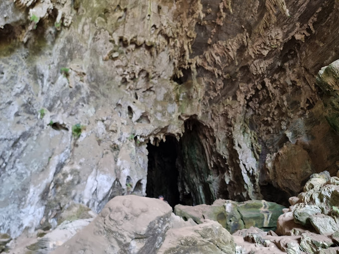
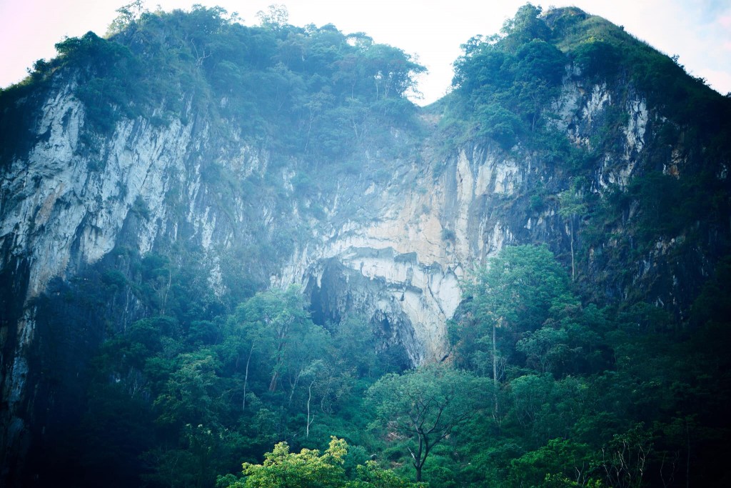
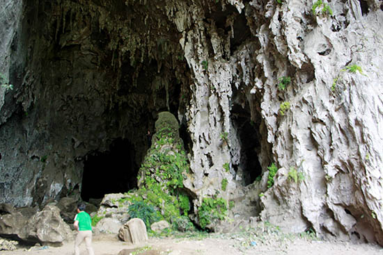
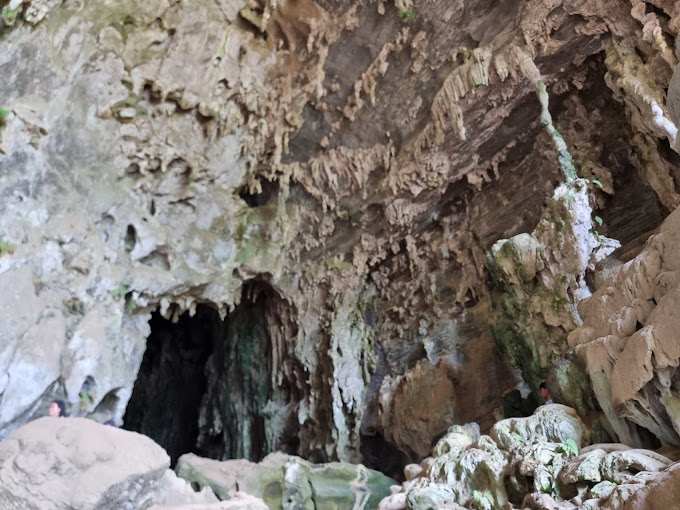


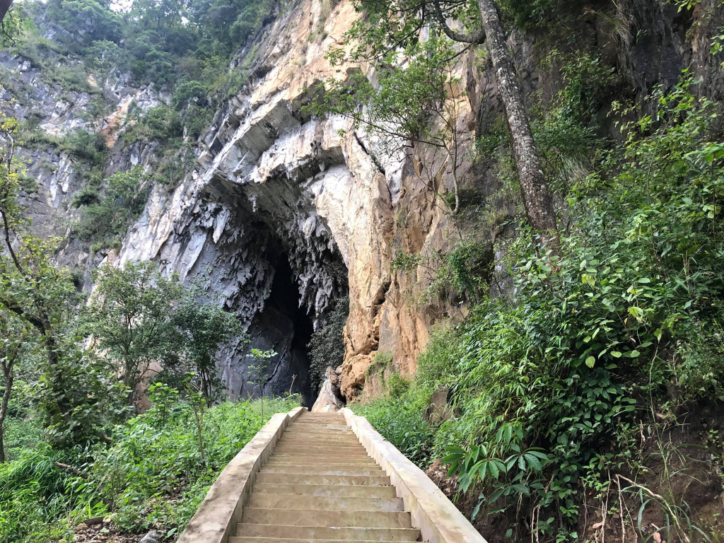
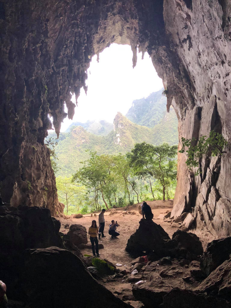
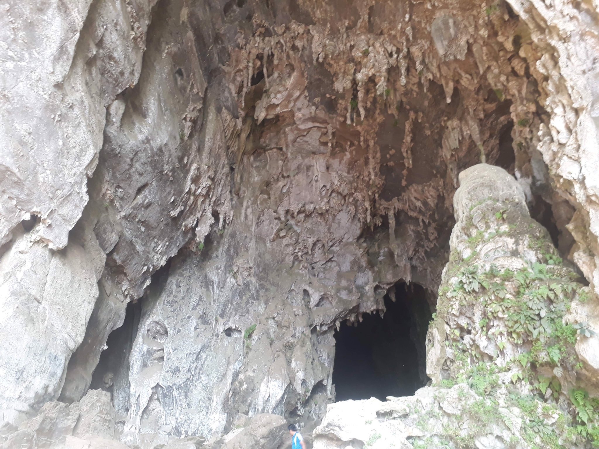
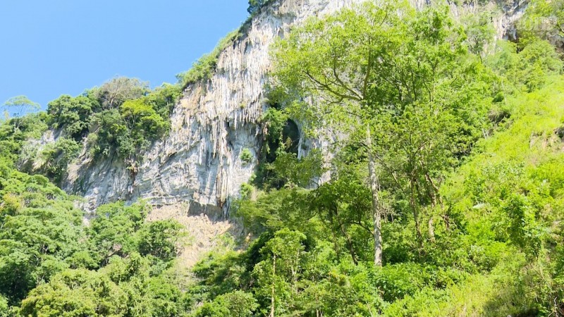
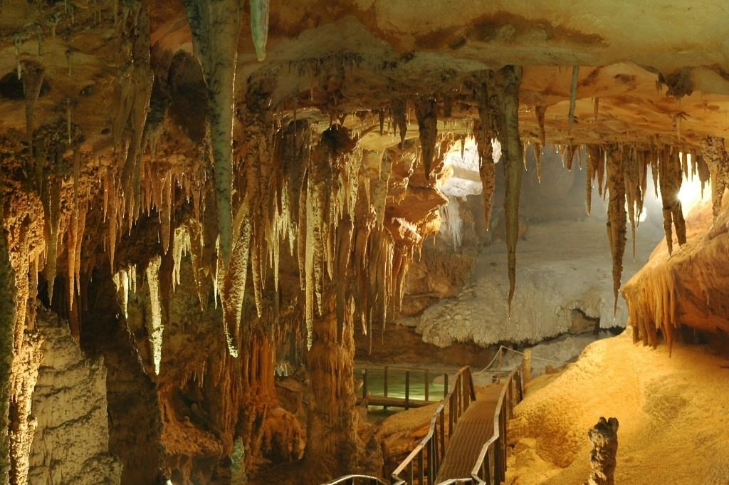
Tham Can Cave, also known as the "A Phu Couple" cave, was the 99th revolutionary base during the resistance war against the French in Son La province. The cave belongs to Hong Ngai commune, Bac Yen district, Son La province. The relic includes two caves: The first cave (dry cave) is located at the foot of U Bo mountain, surrounded by primeval forest, with a cool, airy climate. In front of the cave is the people's fields, covered in all four seasons with green flowers and fruits. The dry cave consists of 2 doors located on the East and West sides, connected to each other, dividing the cave into 3 compartments. The total length of the cave from West to East is about 200m. The western door is about 3m high, 1.5m wide, the entrance to the cave is small and narrow, limiting light. The deeper you go, the more the cave expands, with an average ceiling height of 20 to 40 meters and an average width of 15 to 30 meters. The cave floor is rough and slightly sloping, with many rocks scattered all over the cave floor. The ceiling of the cave has many beautiful stalactites shaped like animals, forests, etc. In the second and third chambers, there are also many narrow niches running along the cave walls, on average 10 to 15 meters deep. Go through compartment 3 to reach the east door. The oval cave entrance is about 50 to 60 meters high, about 20 meters wide at the bottom, and about 30 meters wide in the middle. This is where the Military Intelligence Company of the General Staff temporarily stayed for two days to find a way to cross the Da River to prepare for the 1952 Northwest campaign. According to local people, Tham Biet cave was also the place where soldiers and soldiers were stationed. storing weapons of our army and people in the resistance war against American invasion. In addition, Tham Bien cave is also known in literature as A Phu Couple Cave. According to legend, after escaping from Governor Pa Tra's family to reach the Phieng Sa guerrilla area, My and A Phu (the two main characters in the work) stopped here for a while to avoid being searched by the bandits. Governor. The second cave is a water cave about 20 meters south of the first cave. The entrance to the cave is about 5 meters deep underground. The road down to the cave is steep, has many bumpy rocks, and is very dangerous. The cave is about 300 meters long. The cave is dark, about 7 meters wide, from the cave floor to the ceiling is on average about 10 to 12 meters high, in some places it is only 4 to 5 meters high. The cave floor is a stream flowing along the cave from West to East. This is where the Military Intelligence Company came to get water for daily use during their temporary stay in the dry cave. Tham Can Cave - Resistance Base Area 99 was ranked as a Provincial Historical Monument on May 28, 2012. Source: Electronic information portal of Bac Yen district, Son La province
Son La 1756 view
Rating : Provincial level relics


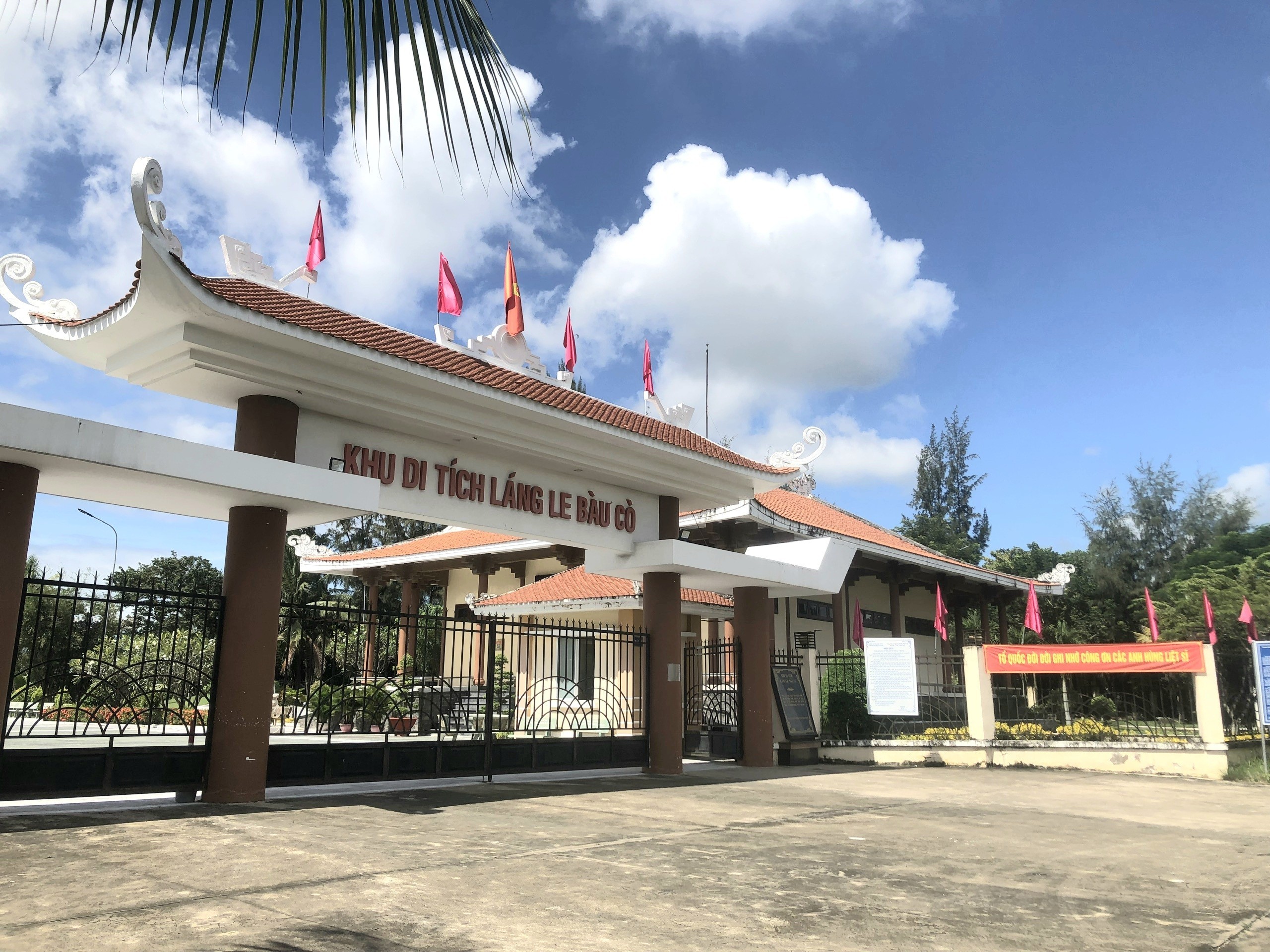
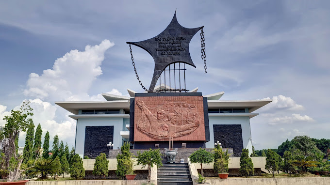
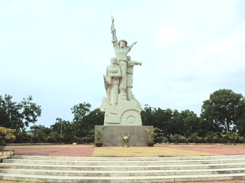
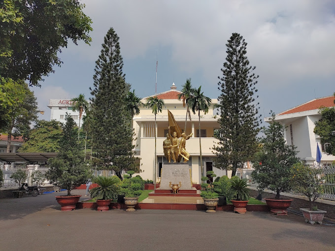
Lang Le Bau Co relic site is located in Tan Nhut commune, Binh Chanh district, Ho Chi Minh City. Lang Le Bau Co is associated with the resistance war against the French invasion in 1948 with major battles that went down in history. Lang Le Bau Co relic was recognized as a city-level historical relic in 2003. The reason it is called Lang Le Bau Co relic area is because the name of Lang Le Bau Co relic area was given by local people. The hamlet was established next to the interlaced canals and rivers. Lang Le Bau Co is located inside a large field with many shrimp, crabs, and fish. Along with many species of birds such as mallards, storks, teal, nuthatches, gongs, partridges, herons, and red armpits come to feed here. Therefore, Tan Nhut people call it by the familiar and rustic name Lang Le Bau Co. Lang Le Bau Co relic is considered the gateway to move to the center of Vuon Thom base and attack the enemy headquarters in Saigon. Previously, Lang Le Bau Co relic area was originally a field of overgrown reeds. On April 15, 1948, the French colonialists sent 3 thousand soldiers and many modern weapons to simultaneously attack the Lang Le Bau Co area to destroy the Vuon Thom base. At that time, the revolutionary armed forces in Lang Le - Bau, because of their small force and rudimentary weapons, had the help of local people along with the advantage of terrain. After just over half a day of fighting, it turned to attack, causing the French army to suffer a large number of casualties. The victory at Lang Le Bau Co killed 300 enemies, captured 30 mercenaries, and destroyed many machines, military vehicles, and guns of all kinds of the enemy. However, on our side, there are many officers and soldiers who heroically sacrificed their lives at a very young age. On October 14, 1966, in Lang Le, the Republic of Vietnam Army Ranger Battalion was destroyed by tourist militia. Lang Le Bau Co relic site has great historical significance for the people of Saigon in particular and the whole country in general. Faced with hatred for the French colonialists, Lang Le Bau Co's army and people fought a war of great historical significance that opened the door for our side and the enemy. For our side, the battle opened the door to heroism in a strong resistance position. As for the enemy, they had to retreat into a strategic position and were destroyed. The French colonialists could no longer form a strategy to defeat the Viet Minh. Moreover, at Vuon Thom base, Lang Le Bau Co also took place a determined battle to protect our base and destroy all sabotage plans of the enemy. Lang Le Bau Co relic area, after the Dong Khoi movement in 1960, was also a logistics and springboard for the armed forces to liberate Long An - Saigon - Gia Dinh. To commemorate the sacrifices of our compatriots and soldiers, in 1988 Binh Chanh district built a historical building in Lang Le Bau Co land with an area of 1000m2. Source: Ho Chi Minh City Electronic Information Newspaper
Ho Chi Minh City 6812 view
Tan Hiep Prison, also known as "Tan Hiep Correctional Center", is located in Quarter 6, Tan Tien Ward, Bien Hoa City. Tan Hiep Prison Relic was ranked as a national relic by the Ministry of Culture and Sports on January 15, 1994. Tan Hiep Prison is one of the six largest prisons in South Vietnam and the largest prison in the Southeast region, built in an important military position, northeast of Bien Hoa town. Ahead is National Highway 1; Behind is the North - South railway line. This is an isolated location, convenient for transportation, easy for protecting, guarding, receiving prisoners from other places and transferring prisoners to Con Dao, Phu Quoc... Tan Hiep Prison has an area of 46,520 square meters with 8 prisons, including 5 prisons for communist prisoners and patriots. The prison is surrounded by 4 layers of barbed wire with 9 bunkers, 3 watchtowers with a team of guards and a modern alarm system. It's called "Correctional Center" but inside is actually a gun warehouse, an interrogation and torture room with the most modern tools. Each prison only has an area of nearly 200 square meters but holds 300-400 people, sometimes up to a thousand people. In particular, there are "repentance" rooms and "tiger cages" that are very small and narrow and living conditions are extremely harsh, prisoners live like in a crematorium. The diet was extremely unhygienic. The prison guards bought rotten rice and rotten fish to fertilize the fields, and fried them in oil to feed the prisoners, leading to many people being poisoned. With the determination to escape the imperial prison, return to the Party and the people to continue fighting and liberating the nation, on December 2, 1956, with the agreement of the Eastern Inter-Provincial Party Committee, the soldiers Communists were "detained" in Tan Hiep prison under the direct direction of comrade Nguyen Trong Tam (Bat Tam) - in charge of the prison Party Committee and a number of other comrades who suddenly broke the shackles. was able to free nearly 500 comrades and patriots. This event caused a stir in the Pentagon. America - Diem hastily mobilized both main forces and security forces, civil guards defending the three provinces of Bien Hoa, Ba Ria, Thu Dau Mot and two special forces to encircle and capture the prisoners, but all were defeated. failure. Our comrades and compatriots who escaped from Tan Hiep prison received help and protection from local facilities and returned safely to base. Among the escaped prisoners were comrades: Bay Tam, Hai Thong, Ly Van Sam... who became the core nucleus of the Dong Khoi movement later. In 2001, to partly recreate the crimes of the US - Diem against our comrades and compatriots imprisoned at Tan Hiep prison and describe the entire Tan Hiep uprising on December 2, 1956. , Dong Nai Museum has collected images, documents, and artifacts displayed at the relic and made a model to serve the research and sightseeing needs of all classes of people. Every day, the monument is open to visitors. Source: Dong Nai Electronic Newspaper
Dong Nai 6187 view
La Nga Victory Relic (at km 104-112 on Highway 20 to Da Lat, in Phu Ngoc commune, Dinh Quan district) was ranked a national historical relic by the Ministry of Culture on December 12, 1986. To cheer for the Viet Bac victory in the fall-winter of 1947 and also to deal a fatal blow to the enemy, the command board of squad 10 decided to organize a big battle, to show the enemy that the Vietnamese people were , Vietnamese people do not easily submit to any enemy; With a spirit of courage and ingenuity after nearly half a year of preparation, studying the terrain, and choosing a location: at 15:12 on March 1, 1948, the La Nga ambush battle began and ended at 15:12 on March 1, 1948. 15:57 on the same day, in just 45 minutes. The victory of La Nga delighted the people of Dinh Quan in particular and the people of Dong Nai in general. This is a victory that demonstrates the cunning and courage of our army and people, causing the enemy to be stunned and defeated. From this victory, our force grew stronger and stronger, contributing to defeating the enemy's plan to attack quickly and win quickly, forcing them into a passive position. The scenic complex of Chong Rock, Mai Waterfall, La Nga River and La Nga Victory Monument is an interesting tourist complex of Dinh Quan. The amazing beauty of Hon Ba Chong, Da Voi Mountain, Hon Dia, along with the natural pagoda at the foot of the rocky mountain are typical clusters that create a harmonious beauty for the Da Chong scenic area. Dinh Quan Da Chong Complex is also a place that retains traces of prehistoric life. Here, under the stone roofs, along the streams and on the slopes along the valley, many production and daily life tools of the ancients made of stone, bronze and terracotta were discovered. During the 30-year resistance war. Dinh Quan is an important part of War Zone D. Da Chong witnessed the formation, development, stationing, and combat deployment of revolutionary forces. Today, a part of the land of Da Chong Dinh Quan scenic area has been used and built into the Dinh Quan District Cultural and Sports Center. In the near future, Da Chong Dinh Quan scenic area will be invested in and renovated, contributing to making the natural landscape more beautiful and becoming an attractive eco-tourism destination. Source: Dinh Quan District People's Committee
Dong Nai 4167 view
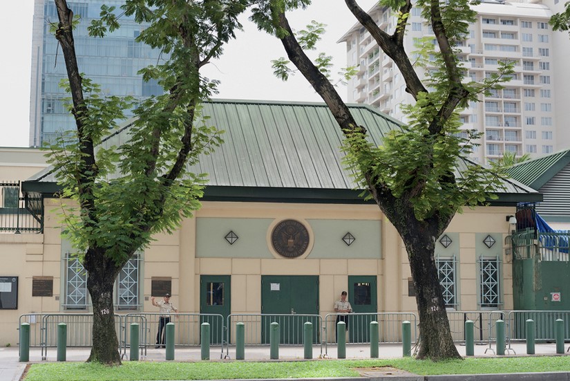
The US Embassy relics, also known as the "White House of the East", are the origin of sinister military and political plots aimed at long-term annexation of Vietnam. The relic site is a 5-storey building built Built in modern architecture, located at the corner of Mac Dinh Chi - Le Duan Street, Ben Nghe Ward, District 1, Ho Chi Minh City, on a plot of land nearly 5,000 square meters. Previously, the US embassy was located at 39 Ham Nghi Street. At around 10:00 a.m. on March 30, 1963, the US embassy on Ham Nghi Street was hit with explosives by the F21 Commando team, collapsing three floors: 1, 2, 3, so the US decided to rebuild it. Construction began on the building in 1965, most of the materials and construction machinery were transported from the US, under the control of American engineers. According to the design, the building is surrounded by 7,800 Taredo stones that can withstand mines and artillery shells. The main door is equipped with thick steel, the other doors are blocked by a special thick bulletproof layer. All doors use automatic systems, including iron doors blocking the way to the upper floors. Inside the building there are 140 rooms with 200 staff serving day and night. In addition, next to the building is also built an additional row of houses called the "Norodom" area exclusively for C.I.A. employees. When inaugurated, the building had only 3 floors. At the end of 1966, two more floors and a terrace were built to serve as a landing place for helicopters. Surrounding the building is a 3m high wall, at both ends of the wall close to Le Duan Street, 2 high blockhouses are built, guarded day and night. The Embassy was completed in September 1967 with a defense system such as a fortress with 60 guards, a bomb shelter, and a radar screen system to control the facade. Immediately after the building was completed, on September 24, 1967, thousands of students flocked to the gate of the US Embassy to fight for "America to stop bombing the North", "America to go home" and issued a notice denouncing the US for "trampling and seriously violating the right to self-determination of the Southern people". But the outstanding event that happened at the US Embassy was the battle of the City Rangers during the General Offensive and Uprising in the Spring of 1968. The target of attacking the US Embassy was added on January 24, 1968 by Ngo Thanh. Van is in charge of general affairs. Ranger Team 11 took on this important mission, including captain Ut Nho (military region reconnaissance captain) and soldiers: Bay Truyen, Tuoc, Thanh, Chuc, Tran The Ninh, Chinh, Tai, Van, Duc, Cao Hoai Vinh, Mang, Sau and 2 drivers: Tran Si Hung and Ngo Van Thuan. Another equally humiliating event for the US Embassy was the chaotic escape that occurred on April 29 and 30, 1975 by the US and its accomplices. Faced with the rapid attack of the Vietnamese army and people in the historic Ho Chi Minh campaign, over 1,000 Americans and more than 5,000 pro-American Vietnamese jostled, pushed, and kicked each other to compete for a place on the terrace of the building. building to be rescued by helicopter. This relic was granted a certificate of recognition by the Ministry of Culture on June 25, 1976. Currently, the US Embassy building has been demolished and a new consulate in Ho Chi Minh City has been built, but next to it is a memorial stele forever remembering the achievements of the special forces soldiers who died in the battle. . Source: Ho Chi Minh City Youth Union
Ho Chi Minh City 4128 view
Nguyen Huu Canh temple, also known as Binh Kinh communal house, is located on the left bank of Dong Nai river, formerly belonging to Binh Kinh hamlet, Binh Hoanh village, Tran Bien canton, now Nhi Hoa hamlet, Hiep Hoa commune, Bien Hoa city. It was ranked as a national historical relic by the Ministry of Culture, Information, Sports and Tourism on March 25, 1991. Nguyen Huu Canh Temple was built around the end of the 18th century. Initially, the temple was small in scale, with walls made of boards and a yin-yang tile roof, about 400m south of the current temple. Documents say: the temple was first rebuilt in the fourth year of Tu Duc (1851); By 1923, the temple was rebuilt at its current location. Nguyen Huu Canh was born in 1650 in Gia Mieu, Tong Son district, Thanh Hoa province in a family with many famous generals in the dynasty. He was a man of both literature and martial arts, accomplished many great victories and was trusted, loved and respected by Lord Nguyen. In the spring of the year Mau Dan (1698), he obeyed Lord Nguyen's order to invade Dang Trong while it was still very desolate. Arriving in Dong Nai, he set up his headquarters at Cu Lao Pho (now Hiep Hoa commune); took Dong Nai land as Phuoc Long district, built Tran Bien palace, took Saigon land as Tan Binh district, built Phien Tran palace, the land expanded thousands of miles. He recruited immigrants to settle down, organized the administrative apparatus gradually and systematically, encouraged land reclamation, and promoted Cu Lao Pho to develop into one of the busiest and most dynamic port towns throughout the century. 18 and officially annexed the new land of the South into the Dai Viet map. After returning from the invasion of the South, the following year he again served Lord Nguyen Phuc Chu's command to lead an army to suppress King Chan Lap and maintain the southern border region. In April of the year Canh Thin (1700), after completing his mission, on the way back to Rach Gam (Tien Giang), he fell ill and passed away on the 16th day of the 5th lunar month, at the age of 51 years old. On the way to his hometown for burial, his coffin was stopped at the land where he once had his headquarters on Cu Lao Pho so that local people could have the opportunity to say goodbye to him one last time. At the mandarin's communal house, local people built a tomb to remember this event. When hearing the news of Nguyen Huu Canh's death, Lord Nguyen was extremely sorry and conferred on him the title of High-ranking official of the Town Chancellor with the title: Thanh Marquis Ceremony and had his tablet enshrined at the Thai temple. Source: Dong Nai Electronic Newspaper
Dong Nai 4066 view

During the period when the Mac dynasty had its capital in Cao Bang, in order to prevent the Le dynasty from attacking, the Mac dynasty restored and repaired Na Lu citadel (now in Hoang Tung commune, Hoa An) and Ban Phu citadel (now in Hung Dao commune). ), Phuc Hoa citadel, in addition to building many other citadels in Cao Bang, making Cao Bang a political and military center in the far Northeast border region at that time. Na Lu citadel and Phuc Hoa citadel are two citadels built before. According to the records of Be Huu Cung in Cao Bang Thuc Luc, Na Lu citadel and Phuc Hoa citadel began in the reign of Tang Y Tong in the year Giap Than, the 5th Ham Thong era (874). Based on the presence of many ancient tombs with stone inscriptions containing the names, addresses, and hometowns of the citadel builders who died here during the Ham Thong Dynasty, it can be confirmed that these two citadels were built during the Tang Dynasty. Na Lu Citadel was built over many different dynasties. When the Mac dynasty came to Cao Bang, it was rebuilt with bricks. Na Lu citadel has a nearly rectangular shape, has a total area of about 37.5 hectares, a length of about 800 m, a width of about 600 m, the citadel has 4 gates. Ban Phu citadel in the capital of Nam Binh, Nam Cuong country of Thuc Phan in the past in Cao Binh (Cao Bang), the Mac dynasty renovated the royal palace in the inner circle of the old capital of Nam Binh and called it Ban Phu citadel or Royal Palace. In the ancient capital of Nam Binh of the Nam Cuong country and the Mac dynasty, Ban Phu citadel still has clear traces. The capital city of Nam Binh consists of two citadels, to protect the citadel, the outer ring has a circumference of about 5 km, including a low hillock area, around the foot of the hill is covered with vertical canvas like a wall, convenient for navigation. Build defense lines. The western wall of the citadel runs parallel to the bank of the Bang River to the beginning of Bo Ma village, connecting the southeast wall of the citadel, flowing in front of Ban Phu, following the foot of the hill to meet National Highway 4, the northeastern side running along the foot of the hill close to the outside of National Highway 4. , up to the top of the mound is the northwest side, continue running along the foot of the hill, out to the river bank and meet the west wall, forming a closed citadel. When the Mac Dynasty established the capital, it repaired and built a number of additional works, in which Ban Phu Citadel (inner citadel - the king's working place) was built higher on the old citadel walls from the Thuc Phan period. The citadel is located on a flat land. Along with rebuilding the capital, the Mac dynasty also built a system of posts and ramparts quite thick around the capital and a number of important border points, forming a system of protecting the capital and protecting the border. gender. Phuc Hoa citadel (Phuc Hoa district) was built in a square style, about 400 m in each direction, including two citadel rings, the distance between the two rings is 80 m. Currently, the southern wall has been completely destroyed. Phuc Hoa Citadel has 2 main gates: The North Gate is open to the national highway to Ta Lung Border Gate today, people often call it Pac Gate, this gate is built in a rectangular style, 8 m wide, 5 m high. , including two gates made of thick, very sturdy wood; The second gate is in the south, opening to the river bank. Both gates were flattened long ago, and now there are no traces left. Near the citadel, in the northwest suburbs along the riverbank, there are many traces of brick kilns. People said that during the process of labor and exploration, many intact brick kilns were found in this area. Through research and surveys, it has been shown that in Cao Bang, the Mac dynasty renovated, embellished and built many citadels and fortresses, including repairing, embellishing and rebuilding Ban Phu citadel, Na Lu citadel, and Phuc citadel. Hoa. These fortifications have formed a quite solid system of protecting the capital. Up to now, of the ancient citadels built by the Mac Dynasty during the capital period in Cao Bang, some of the citadels built of earth only have traces left, but the citadels built of stone are still very clear. Source: Cao Bang Electronic Newspaper
Cao Bang 3819 view
Chot Mat Tower Historical-Cultural Relic, located in Xom Thap hamlet, Tan Phong commune, Tan Bien district, Tay Ninh province, was recognized by the Ministry of Culture and Information (now the Ministry of Culture, Sports and Tourism) as historical - cultural relic on July 23, 1993. Also one of the last three ancient towers remaining in the South of our country. Having undergone many restorations in 1938, 2003 and most recently in 2013. Despite undergoing restorations, the Chot Mat ancient tower relic site has given itself a new look but still remains retains the spirit of ancient architecture. The entire Tower is built of brick and slate with the top of the tower tapering upward, from the ground to the highest point of the tower is estimated to be 10m. In addition, this ancient tower is located on a high mound in the middle of the field, so from a distance it looks like a pen rising gradually. In 2003, the People's Committee of Tay Ninh province decided to approve the investment project to restore, embellish and preserve Chot Mat tower relics and carried out the restoration, restoration, display and opening of the excavation pit in 2003. into use. On November 27, 2019, the Provincial People's Committee issued a Decision regulating the decentralization of management, protection and promotion of the value of historical and cultural relics and scenic spots in Tay Ninh province. Decision to assign the People's Committee of Tan Bien district to directly manage 4 relics, including the National Historical-Cultural relic Thap Chot Mat. In particular, the Chot Mat Tower Historical-Cultural Relic in Tan Phong commune, Tan Bien district was chosen to be part of the tourism development link of Tay Ninh Province. This is a tourist destination worth exploring, contributing to tourism development in Tan Phong commune in particular and Tan Bien district in general. Source: Tay Ninh province electronic information portal
Tay Ninh 3748 view
Bac Cung Temple (literally known as Thinh Temple) in Tam Hong commune, Yen Lac district is one of four large temples around the Ba Vi mountain region and the Red River Delta worshiping Saint Tan Vien. The temples: Tay Cung, Nam Cung, and Dong Cung are on the other side of the Red River in Son Tay territory. These are four temples that were built and preserved relatively carefully by the people. The temple is located in the middle of fertile fields on a 10,000 square meter plot of land next to winding canals, surrounded by rich and densely populated villages. On both sides, the left desert and the right desert stand majestically and silently, covering a large brick yard, looking up to a unique architectural work. Thinh Temple was built 20 centuries ago on the foundation of a small temple worshiping Saint Tan, where he had previously let his troops stay during a mission to help people clear land and manage water. The divine genealogy passes down that: Saint Tan (still called Son Tinh), whose name is Nguyen Tuan, was born on January 15, Dinh Hoi year in Lang Xuong cave, Trung Nghia commune, Thanh Thuy district, Phu Tho province. He lost his father at a young age and lived with his mother and two cousins, Nhuy Hien and Nguyen Sung. Every day, the three brothers crossed the Da River and went to the Ba Vi mountains to clear fields and farm, looking for a living. Here, Nguyen Tuan met Princess Thuong Ngan, was adopted by her, and gave her a walking stick and many magic spells to save humanity. After defeating Thuy Tinh and marrying Princess Ngoc Hoa, he refused the throne that King Hung wanted to give him, and with his two younger siblings traveled everywhere, helping people clear land and water, and was respected by people everywhere. When passing through the Tam Hong area, he let the troops rest and taught the people to grow rice and fish... After he left, the villagers came to the place where the Holy One rested and saw that there were still some packets of hearing left there, so after This temple is called Thinh temple. There is also a story that: when letting the army stay here, Saint Tan taught the people to butcher Thinh, so the people called the temple that name. From a small temple, during the reign of King Ly Than Tong (1072-1128), the temple was rebuilt into a large temple. This is where the king came to pray for longevity. During the reign of King Minh Mang (1820-1840), the temple was repaired many times. During the reign of King Thanh Thai, the Tri of Yen Lac district appointed monk Thanh At to restore the temple. The project lasted until the 6th reign of Khai Dinh (1900-1921). Through many ups and downs, the temple continues to be preserved and preserved by local people. On January 21, 1992, the temple was recognized by the Ministry of Culture and Information as a cultural and historical relic. Every year, the Thinh Temple festival is held from the 6th of the first lunar month to the 20th of the first lunar month. The festival includes sacrifices, palanquin processions from villages inside and outside the commune and many folk games will be held. Source: Vinh Phuc province electronic information portal
Vinh Phuc 3639 view
Mai Xuan Thuong was the leader of the Can Vuong movement against the French at the end of the 19th century in Binh Dinh. Mai Xuan Thuong was born in the year of Canh Than, 1860, died in the year of the Pig, 1887, from Phu Lac village, Phu Phong district, Tuy Vien district, Binh Dinh province (now Phu Lac village, Binh Thanh commune, Tay Son district, Binh Dinh province). His father, Mai Xuan Tin, was the chief father in Cao Bang. His mother, Huynh Thi Nguyet, was the daughter of a noble family in the village. Mai Xuan Thuong is inherently intelligent and eager to learn. At the age of 18 (1878), he passed the Baccalaureate at Binh Dinh Examination School. At the age of 25 (1885), he passed the bachelor's exam. Responding to King Ham Nghi's Can Vuong edict, Mai Xuan Thuong returned to his hometown of Phu Lac, recruited insurgents, set up a base on Sung island to raise the Can Vuong flag against the French, then Mai Xuan Thuong brought his forces to join the army. The insurgent army was led by Dao Doan Dich and was appointed by Dao Doan Dich to the position of Military Salary Officer (in charge of food for the insurgent army). From then until 1887, the Can Vuong movement in Binh Dinh developed strongly and spread to Quang Ngai, Phu Yen... attracting tens of thousands of people from all walks of life to participate. On September 20, 1885, Dao Doan Dich died and assigned all his forces to Mai Xuan Thuong. He chose the Loc Dong mountain area (now in Binh Tuong commune, Tay Son district) as his headquarters and organized a flag worshiping ceremony, calling on scholars, literati, and people to join the movement to fight against the French. During that ceremony, insurgents from many regions in Binh Dinh province agreed to honor him as the Marshal leading the uprising and raised the slogan: "First to kill the left, later to attack the West". In early 1887, the French army under the command of Lieutenant Colonel Cherrean and the royal army led by Tran Ba Loc along with Minister Trira launched a major attack on the headquarters of the Can Vuong movement in Binh Dinh, the battle The fighting between the insurgent forces and the French enemy was extremely fierce, the fight was unequal, and in the end the insurgent force was pushed back. In March 1887, after a fierce battle in Bau Sau (An Nhon town, Binh Dinh province), Mai Xuan Thuong was seriously injured, the insurgents withdrew to Linh Dong secret area. On April 21, 1887, Tran Ba Loc surrounded and captured the Linh Dong secret base and captured a number of insurgents, including Mai Nguyen Soai's mother. On the night of April 30, 1887, Mai Xuan Thuong sent a suicide squad to break into Tran Ba Loc barracks, relieve the captured people, and he and a group of 50 subordinates crossed the mountain into Phu Yen and continued to resist. battle, but when she reached Phu Quy Pass (boundary between Binh Dinh and Phu Yen), she was captured by Tran Ba Loc's ambush and taken to be beheaded at Go Cham (East of Binh Dinh Citadel). The mausoleum of patriot Mai Xuan Thuong is located on a high hill of the Ngang mountain range (in Hoa Son village, Binh Tuong commune, Tay Son district, Binh Dinh province) about 50km northwest of Quy Nhon city; The mausoleum was built on a land area of 1988m2, inaugurated on January 22, 1961. Overall, the mausoleum is designed in the style of an ancient mausoleum, surrounded by low walls. The Lang gate (three gates) is made up of 4 square pillars, the top is tied in the style of a gourd and a vase, bearing the architectural appearance of a communal house or temple gate of the late 19th century. In the middle of the Mausoleum is Mai Xuan Thuong's tomb, rectangular in shape in the East - West direction; At the head of the grave is a stone stele engraved with an inscription recording the biography and career of Mai Xuan Thuong: The relic was ranked at the National level by the Ministry of Culture and Information on April 20, 1995. Source: People's Committee of Tay Son District, Binh Dinh Province
Binh Dinh 3556 view
Hoc Mon District Palace is located at No. 1, Ly Nam De Street, Hoc Mon Town, (next to the District People's Committee headquarters) and is the place where many outstanding fighting events have been recorded throughout the long history from 1885 to the Southern days. Complete liberation of the People of 18 Betel Garden Villages. After defeating Chi Hoa Fort, the French colonialists built a 3-storey wooden house here to use as a military post. When Tran Tu Ca took office as Governor of the Palace, he used the Station as the Palace of Binh Long district. Originally a cunning drunkard of the French colonialists, Tran Tu Ca was led by a group led by Mr. Phan Van Hon (Quan Hon) and Nguyen Van Qua (Chanh Lanh Binh) of nearly 1,000 insurgents who came to burn the District Palace, captured and head cut off in the middle of the market. That was February 8, 1885, At Dau Tet. Afterwards, Hoc Mon District Palace was rebuilt with a blue stone foundation, brick walls, and a defense system from the upper floors to the fence. The architecture is similar to the Military Fort, so the locals call it Hoc Mon Fort. Tran took over from Tran Tu Ca as Governor of Ngon district, moving to Tra District and then Tho District. This was a long period of time when the people of the Hoc Mon region suffered from many cruel and despicable scenes from the French colonialists and their oligarchic henchmen mentioned above. With the indomitable tradition of Hoc Mon people. On June 4, 1930, around 6 a.m. in front of the District Palace, hundreds of Hoc Mon people protested demanding "abolition of poll tax, reduction of license and market taxes, and granting land to poor farmers." Tra District invited the leaders into the Palace to negotiate, but they cunningly arrested them, including Mr. Le Van Uoi (Secretary of Tan Thoi Nhi Commune), who was the leader of the protest. People were undaunted and fiercely demanded that Tea District release those detained. The protest group became more and more crowded, the fighting spirit spread somewhat, causing Tra District to give in. On the one hand, they released the detained people, on the other hand, they called the officials in Saigon for help. 2 hours later, the struggle was led by two men, Blachole and Nobbot, who opened fire on the protest group, causing many casualties. But the most impressive historical event at Hoc Mon District Palace was the Southern Uprising on November 23, 1940. Hoc Mon Fort is very solid, built of green stone like a fortress, about 15 meters high, has a gun emplacement and a defense system with battlements guarded by a platoon of green soldiers. On November 22, 1940, France reinforced one more platoon to deal with the situation. On the afternoon of November 22, 1940, Mr. Do Van Coi's army broke into the town, disguised as civilians, ambushed behind the Station waiting for orders to rob the Station. Another army wing has the task of destroying bridges, cutting down trees blocking roads, and occupying offices and houses... The army wing from Phuoc Vinh An, Tan Thong, Tan An Hoi, Tan Phu Trung is led by Mr. Pham Van Sang and Dang Cong Binh commanded, started from Ben Do hamlet, attacked the house, killed 1 person, collected 4 guns, and took control of the situation here (Tan Phu Trung). Immediately this army was ordered to pull back to Hoc Mon. The Long Tuy Thuong army was commanded by Mr. Bui Van Hoat. The army of General Long Tuy Trung was commanded by Mr. Do Van Day and Le Binh Dang. At around 24:00 on the night of November 22, 1940, the sound of artillery fire had not yet been heard in Saigon. After consulting, the army commanders united to attack the enemy's post. Immediately the troops headed straight to Fort Hoc Mon, where District Chief Bui Ngoc Tho resided. Two insurgents named Nghe and Kinh volunteered to enter the front gate and sacrificed their lives. Insurgents from all directions rushed into the Fort like water bursting its banks. Faced with the power of the insurgents and the masses, the soldiers in the Station no longer had the spirit to resist and fled in disarray. The insurgents completely occupied the inside of the station, but upstairs, the enemy still stubbornly used guns to shoot sporadically, at the same time calling Saigon and Thu Dau Mot for emergency help. Because he was eager to capture the name of Tho District, comrade Do Van Day climbed up to the upper floor of the Station by clinging to the gutter. Halfway up, he was hit by bullets, the comrade fell and died later. The battle was at a standstill when enemy reinforcements arrived. Unable to hold out, the insurgents withdrew from the town, dispersed to the villages, the armed forces withdrew to Ben Do hamlet (Tan Phu Trung) and then moved to My Hanh hamlet (Duc Hoa). Although the attack on Hoc Mon Fort (later called Hoc Mon District Palace) failed, it left a deep impression in the hearts of all civilians admiring the courage of revolutionary soldiers in the fight against colonialism. steal the country. During the historic Ho Chi Minh campaign, at 7:00 a.m. on April 30, 1975, Hoc Mon town was completely liberated, the National flag fluttered above the District Palace, where District Chief Nguyen Nhu Sang and his gang sai has been running away since last night. Today, Hoc Mon District Palace is chosen as the District Museum, where many documents are displayed, illustrating the ups and downs of historical periods as well as the revolutionary fighting spirit of the army and people in Hoc Mon district over the past two years. resistance war against French colonialism and American imperialism. A monument placed in front of the Hoc Mon District Palace relic represents the indomitable sacrifice of the army and people of 18 Betel Garden Villages, recognized as a national historical and cultural relic. Source: Hoc Mon District People's Committee
Ho Chi Minh City 3370 view
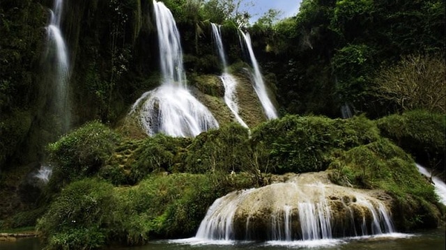
In addition to the name Dai Yem, this waterfall is also called "Nang waterfall" or "Ban Vat waterfall". The waterfall originates from two streams of Bo Co Lam and Bo Ta Chau, located at the confluence of Vat stream and Bo Sap stream, in Muong Sang commune, Moc Chau district. Legend has it that more than 700 years ago, there was a couple who loved each other dearly. But because of the war, both had to separate. The boy went to war, and the girl went to the waterfall every day to wait for her lover to return. One day, it rained and stormed, the water flooded the entire waterfall. The girl was swept away, leaving only the token of love, an embroidered scarf, scattered near the waterfall. The villagers mourned so they named the waterfall "Dai Yem", which in ancient Thai means "Love Thread". Because of this touching legend, the waterfall has become a place to "prove love" and an ideal destination for many couples. Currently, the waterfall is being preserved and managed by Dai Yem Waterfall Tourist Area. Like a girl in the age of love, Dai Yem waterfall is sometimes gentle and peaceful but also sometimes fierce and passionate. To fully feel the wild beauty mixed with a bit of dreaminess of the waterfall, you should come here during the pouring water season. The period from April to September is the best time to see the falls. At this time, the stream flows rapidly, the amount of water pouring in is huge, creating a white, mesmerizing curtain, making viewers overwhelmed and excited. But if you want to see something gentler and quieter, you can also visit the waterfall in the dry season. At that time, the waterfall will become gentle and full of dreams. The sound of the gurgling stream mixed with the chirping of birds from the deep forest, all blend together, creating a poetic scene. But if you want to see something gentler and quieter, you can also visit the waterfall in the dry season. At that time, the waterfall will become gentle and full of dreams. The sound of the gurgling stream mixed with the chirping of birds from the deep forest, all blend together, creating a poetic scene. The first experience that any tourist cannot miss is admiring the majestic beauty of Dai Yem waterfall. The waterfall is more than 100m high, divided into two distinct branches: the upper waterfall is about 4,000 m2 wide with 9 floors symbolizing 9 levels of love, while the lower waterfall is smaller (area of about 300 m2) and includes 3 floor. The two clusters of waterfalls are about 200m apart, flowing day and night. From a distance, they look like a soft peach band winding around the cliff. With its poetic and magical beauty, this waterfall has become a place to visit, picnic, check in and take photos for many tourists, especially young people.
Son La 1656 view
From January to December
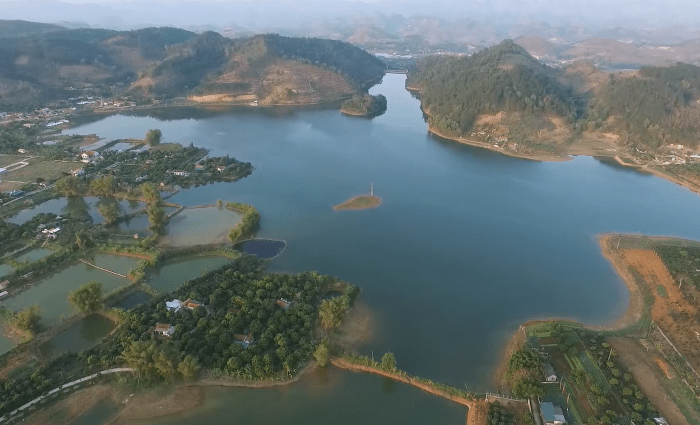
Tien Phong Lake in Son La is a typical place of wild and majestic beauty, but extremely romantic in the Northwest mountains and forests. Visiting this land, visitors will admire the charming feng shui and enjoy the fresh air of nature, and have many interesting experiences when yachting on the lake. Located in the middle of the vast steppe, Tien Phong Lake has thousands of winds and warm sunshine, captivating many tourists. Tien Phong Lake in Son La is located in Muong Bom commune, Mai Son district. The place is located right next to National Highway 6, 23km from Son La town, 7km from Hat Lot town and 2km from Na San airport. This is a prime location surrounded by majestic mountains. It is a place surrounded by beautiful nature - in the middle of the immense steppe. To the East and North are two majestic mountain ranges, one after another. To the East is the Na San plateau full of fruits and thousands of green tea hills. All have created a charming landscape, attractive nature, bringing moments of relaxation and peace, holding the traveler's feet. The scenery of Tien Phong Lake is created from Tien Phong dam made of earth and solidified by solid concrete panels. Tien Phong Dam is 23m high, 120m2 wide and 120m long. Coming here, visitors can witness with their own eyes the beautiful natural scenery with a stretching blue color. The vast lake surface is jade green, in the distance there are deep green tropical forests and deep clouds and sky. Nature guides us, people do not want to leave the majestic landscape of Tien Phong. Cruising is an attractive experience for tourists when visiting Tien Phong Lake in Son La. There's nothing more wonderful than floating on the water and taking in the wonderful view of nature. You can choose to row a manual boat, a pedal boat or a motor boat depending on your preference. Many tourists also choose to fish to preserve the beautiful nature. Just do it the way you like, immerse yourself in nature to feel the slow passage of time, preserving the most wonderful emotions. From a distance, the floating island looks like a turtle's shell floating in the middle of the lake. The landscape here is always green and fresh from the young grass and the wind. The wind brings cool and refreshing steam to the small island. Exploring the floating island, visitors will be immersed in the fresh nature here, enjoying the freshest and most peaceful air of their lives.
Son La 1767 view
From January to December

Possessing an impressive height above sea level of 2,000 m, the mountain peak is located in the Vietnam - Laos border area and has received the love of many tourists in recent years. After arriving at the center of Moc Chau district, you need to travel another 40 km to reach the foot of the mountain. In addition to the name Pha Luong peak, visitors can also use the name Bo Lung to talk about this tourist destination. When you come here, you will experience the feeling of conquering the mountain peak with impressive heights. In particular, it is the feeling of seeing the majestic and wild scenery from above that is not available everywhere. For those who love to explore and are passionate about adventure sports, this will be a great destination. You can also enjoy the fresh, cool atmosphere of the Northern highlands and relax after the stress and fatigue of life here. For young people, this is an ideal check-in point and great "cloud hunting" in the early morning. Featuring the climate of the North with four distinctly changing seasons, visitors can reach Pha Luong peak at any time of the year. Because this place at each time will bring its own unique beauty and impression to tourists. However, because the road to the top of the mountain is up to 2000m high and difficult, visitors should choose a travel time from March to April. This is the time with warm sunshine and no rain, convenient for climbing. The mountain is safer as well as helps the sightseeing process. One of the famous check-in points when conquering Pha Luong peak is the uniquely shaped rock outcrop. The breadth of space and scenery, along with the rocky outcrop that juts out, make your photo even more impressive. Visitors do not need to worry because the stones are quite large and thick. Be careful when checking in in the rain because they are easily slippery. In addition to experiencing the scenery and atmosphere at the top of the mountain, visitors also have the opportunity to discover more about the typical Lao market. You can find handicraft products, specialty dishes in Moc Chau, dried meat,... as gifts for relatives or friends after the trip. Although it is an attractive tourist destination and brings wild and impressive beauty to tourists. But Pha Luong peak is quite difficult to conquer, so in addition to experience, you also need to know the following notes: With an altitude of 2000m, when you reach the top of the mountain you will see the temperature drop quickly. Especially, if you come in the winter, the temperature is lower, so you need to bring warm clothes, towels, wool hats, gloves, etc. To avoid sudden changes in temperature that affect your body. During climbing, you should use specialized shoes for climbing. Do not wear flat shoes or sandals because they can cause slipping and danger during movement. Visitors should carefully consider their health and mobility before deciding to climb Mount Pha Luong. People with cardiovascular diseases should not move to the mountains. Before conquering the mountain peak, you should have a light snack and drink water to give yourself more energy. Absolutely do not arbitrarily throw trash indiscriminately while moving or visiting the mountain top. Always bring identification documents to present for check-in procedures at the border station.
Son La 1919 view
From March to April
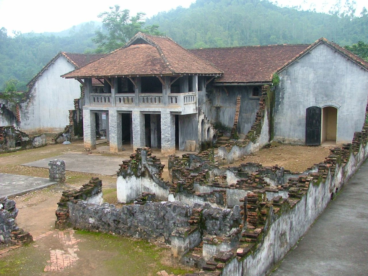
In the heart of the city, there is a hill named Khau Ca lying beside the Nam La stream. This place also preserves historical evidence of Son La Prison - evidence of a historical period of revolutionary struggle and the spirit of injustice. The remains of resilient communists who were imprisoned by the French colonialists, and the Son La museum, which displays many precious artifacts, introducing the historical and cultural traditions of a community of 12 ethnic groups united together. together to build Son La into a rich province of Vietnam. Son La Prison was built by the French colonialists in 1908 with an initial area of 500 m2. The prison is built quite solidly: the walls are built of stone and brick, the roof is covered with corrugated iron, there is no ceiling, the beds for prisoners are also built of stone, the surface is cemented, the outside edge is attached with a system of vertical leg shackles. along the length of the floor. In each cell there is a floating toilet built higher than the floor, without a lid, without flushing water, and not cleaned regularly. With such a design, in the summer, the Lao wind of the Northwest region causes scorching heat, the frost creates cold, bone-chilling cold in the winter, combined with the polluted environment in the area. Each cell has caused diseases to arise and spread very quickly among prisoners. In 1930, the Communist Party of Vietnam was born and led the people to fight against the brutal regime of feudal colonialism. The struggle movement surprised the enemy, who frantically sought every way to suppress and arrest patriotic Vietnamese people in an attempt to quell the revolutionary movement. On the other hand, strengthen the construction and expansion of the prison system throughout the country, paying special attention to Son La prison. In 1940, Son La Prison was expanded to add a large prison to hold more prisoners and send a number of female prisoners to Son La, but that plot failed to materialize. Thus, through 3 times of construction and expansion, Son La prison has a total area of: 2,170m2. The French colonialists turned this place into a living hell to imprison, deport and destroy the will of the Communists to fight. With an extremely harsh prison regime and extremely cruel torture methods, the enemy thought they could destroy the spirit and body of the revolutionary soldiers, but this place became a revolutionary school. network, train the will and supplement the Party and the revolution with loyal communist soldiers and party members, most notably the role of comrade To Hieu and many other loyal comrades. After being devastated twice by the enemy's bombs, the old relics are now dilapidated, remaining almost nothing more than a pile of destroyed bricks, and the ruined prison walls are a testament to the brutal crimes of the enemy. What remains intact is the To Hieu peach tree, a symbol associated with the name of the steadfast Party Secretary of the prison, which still blooms brilliantly when spring comes... In 1952, when the French colonialists withdrew from Son La, they bombed to erase traces of their crimes. The second time in 1965, the American imperialists raided Son La Town and destroyed part of the prison. In 1980, Son La Museum carried out the first restoration: Leveling bomb craters, rebuilding some surrounding fence sections; The second time, in 1994, restored the two watchtowers, the kitchen, the large prison, reinforced the underground bunker, and built the walls of the cells according to the traces of the old foundations. In 1994, Son La Museum intended to restore the entire relic site to its original form, but could not find complete records, so there was not enough scientific basis to restore the entire site. Just build the walls a little higher so visitors can visualize the structure of the Son La prison complex. Every year, the historical site of Son La prison welcomes hundreds of thousands of tourists to visit, research, study... Surely, at some point, tourists come to Son La, return to the mountains and forests. Northwest to experience and reminisce about the war that took place more than a century ago; With the skillful leadership of the party, the passionate patriotic spirit willing to sacrifice for national independence, the strong solidarity between peoples... We have left behind a peaceful country for today's posterity.
Son La 1714 view
From January to December
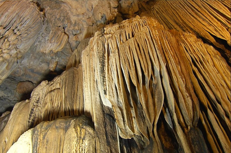
With an area of 6,915 square meters, Bat Cave contains an underground water source that never dries up. The name Bat Cave originates from the fact that in the past, there were large colonies of bats living and nesting here, but now they have left elsewhere. However, the name Bat Cave is still called by people here to this day as a familiar name from a long time ago. Above the ceiling of the cave are high stone arches hanging down to form magical shimmering stalactites. These stalactites form many interesting shapes such as fairies, fairies, animals... All create a scene that is both sparkling and majestic. This is a place that when traveling to Moc Chau you should not miss! Legend has it that once upon a time, there was a sacred dragon who, when flying over this land, saw the majestic mountains and cool climate, so he humbled himself and hid in Bat Cave and resided here. That's why this mountain range has many mysterious colors such as: white in the morning, blue at noon, then pink in the afternoon, and finally purple at sunset. People here often tell each other that it is because the dragon's body is surrounding the mountain. Later, when the dragon died, it released 7 pearls to repay the favor. The 7 pearls are the 7 mountains that later created Bat Cave. Thanks to the legendary stories that have been passed down from generation to generation, this place becomes even more attractive and makes many curious tourists want to come here to verify. From the moment you enter from the cave entrance, the light shining into the cave will make you feel like you are lost in a fairyland with different dark and light shades. Visitors will admire the beauty of the limestone stalactites hanging down, creating an amazing natural picture. Furthermore, these rocks also have many different shapes, making them interesting for visitors. The most special is the stone block shaped like a man and woman in love in the shallow lake in the middle of the cave, a highlight that makes everyone admire. In the cave, in addition to the shapes created from limestone blocks, there are also many banyan trees whose roots form shapes on the ground such as elephants, tigers... Another special thing about Son Moc Huong Cave is that the middle of the cave is arched higher than other places in the cave, with a stone curtain at the entrance. This is called the "princess" chamber, which is also an attraction in this place. This. Bat Cave is both a place to visit and a place to explore with forests and trees growing around, so visitors need to pay attention to the following things: Because the cave is located in a dense forest, visitors should wear comfortable and covered clothes to both climb the mountain and avoid being bitten by insects or mosquitoes. You should also bring mosquito spray to ensure safety. , especially with children. When visiting Son Moc Huong Cave, parents need to pay attention to their children's health when climbing the mountain and visiting the cave, then provide timely solutions if the child is too tired or too hyperactive to run around. toss.
Son La 2626 view
From January to December
Moc Chau has four seasons: spring, summer, autumn, winter with mild weather and flowers and fruits all year round. In January, the plateau is green with budding tea hills, peach blossoms, plum blossoms, apricot blossoms, cherry blossoms... From mid-May, plums begin to ripen, people harvest plums and sell them to lowland traders. There are no flowers in summer, nor is it strawberry season, but this place is very suitable for picnics because of the fresh air and many outdoor activities. The persimmon season in Moc Chau starts from August to December every year. In particular, the crispy persimmon season usually comes earlier, from August to October, while from October to the end of the year is the season for astringent persimmons. The white mustard season in Moc Chau begins in November. In December, bright yellow wild sunflowers decorate the plateau. Moc Chau is nearly 200 km from Hanoi. If traveling by motorbike, you should follow the old Highway 6 because there are many beautiful scenery along the way, but you should pay attention to the steering wheel because the road is quite degraded. The journey takes about 4-5 hours. On the way, you will pass the S-shaped road in Van Ho district. Most travelers stop to admire the scenery and check-in at this soft S-shaped curve. If you take a bus, you can choose routes to Son La from My Dinh or Yen Nghia bus station, then get off at Moc Chau with a high-quality bus ticket price of about 200,000 VND. If you drive your own car, you don't need to worry too much because the road is big and easy to go despite many steep passes. Be careful, drive at the right speed and pay attention to the lane when passing. In the summer, the roads are less foggy but visibility is limited when it rains. The section that may be cloudy is the road from Thung Khe section. Moc Chau has many motels. However, to get quality accommodation during peak season, you should still call to book in advance. There are eco-lodges (with mountains, lakes, stilt houses) or homestay-style community motels. The price of a room is about 200,000 - 300,000 VND per night but there are also many motels with lower prices. Some suggested "chill" homestays are MAMA's House, Le Chalet du Lac, Fairy House Moc Chau, House By Lake, The Nordic Village, Moc Chau Retreat... Room prices range from 300,000 to 1,000,000 VND per night. To fully explore Moc Chau, you can go quickly in 2 days. If you have more time, about 3-4 days is best, you will have plenty of time to find beautiful camera angles to take photos or go to neighboring famous tourist areas such as Thung Nai, Mai Chau, Hoabinh water electric... Places you can visit: Ban Ang pine forest, Mu Nau plum valley, Sunflower garden, Moc Chau tea exchange, Chieng Khoa waterfall, Nang Tien waterfall, Dai Yem waterfall, Grassland 68, Nguyen Thuy village, Pha Luong peak. Eateries and restaurants are located along the town center passing through Highway 6. In addition to specialties such as plums, tea or milk, Moc Chau is also famous as a delicious place to eat. The dishes not to be missed when coming here are fried veal, fried stream fish, multi-dish lentil fish, salmon hot pot, pork blood pudding, buffalo meat on the stove, vegetables dipped in fish intestine sauce or five-color rice. If you want to eat dairy veal, you can find restaurants Dong Hai, Xuan Bac 181, Nam Hung 70, or Lan Hong 64, Ve Quan Moc Chau... A strange dish to try is Moc Chau fresh milk hot pot. The broth is simmered from bones and vegetables, a moderate amount of milk is added to give it a milky white color and mild flavor, and corn is added for sweetness. When the hot pot begins to boil, the layer of milk on top begins to thicken, giving it a fatty and fragrant taste. This is also the time when the hot pot broth is at its most delicious. In the past two years, Moc Chau has also been famous for producing strawberries with quality not inferior to those of Japan or Korea because they are grown using Japanese technology. Winter will be the strawberry harvest season on farms with gardens filled with ripe red strawberries, sweet and sour taste, and if eaten with Moc Chau yogurt, it is very easy to become "addictive". In the summer, after plum season, there will be melon season with sweet fragrant fruits. You can buy tea, milk, cat apples, corn, corn wine... as gifts from these locations: intersection 73 near town, sub-area 32 and Bo Bun, intersection 70, peach garden intersection, sub-area Chieng Bi area. Moc Chau usually has warm sunshine during the day, but the night temperature is quite low and foggy. You need to bring enough warm clothes to ensure your health, and check your vehicle's lights before departing. Do not litter, step on people's mustard beds or climb on trees, break wild peach branches, plum branches, flowers...
Son La 1970 view
January to December
The windy Moc Chau plateau is famous for its poetic scenery and heavenly landscapes, and Ngu Dong Ban On is one of them. The mysterious cave system, untouched by human hands, is an attractive destination for tourists, especially those who are passionate about adventure. Coming here, you will have the opportunity to admire a masterpiece created by nature, wild but no less splendid. Ngu Dong Ban On is a system of 5 caves located deep underground, located in Ban On area, Moc Chau Farm town, Moc Chau district. These caves were discovered in 2006, after a historic flood. With its pristine and mysterious beauty, Ngu Dong has become an attractive destination in Moc Chau, attracting enthusiasts of exploration. The climate in Moc Chau plateau is extremely cool and pleasant, especially during the periods from April to July and September to December. At this time, it is mildly sunny, with little rain, suitable for activities. Explore caves. Besides, this is also the peak tourist season in Moc Chau, visitors can admire the windy plateau as well as participate in other fun and entertainment activities. From August, Moc Chau enters the rainy season, with low temperatures, bad weather and lots of rain. The path up to the cave is also more difficult due to the wet and slippery ground. Therefore, if you intend to travel to Ngu Dong Ban On, you should avoid going at this time. Ngu Dong Ban On has a pristine and mysterious beauty, a challenge that every tourist always wants to conquer. Welcoming tourists at Ngu Dong are countless fascinating and unique experiences. To fully explore this complex, visitors must spend at least one day. To get to Ngu Dong, you have to cross a long and equally dangerous road. On both sides of the road are cascading tea hills, layered and beautiful. The road is more than 20 km long, winding around the green tea hills, looking from afar like a strip of green silk lying across the windy Moc Chau plateau. The biggest attraction on this road is the brilliant beauty of thousands of flowers. Each season will be a different color of flowers, flower carpets stretching across the mountain slopes, as beautiful and dreamy as the flower paradise of Pa Phach village. On the way there is a small house, which is both a resting place and a coordinate for you to admire the scenery. Ngu Dong Ban On is a system with 5 caves, including cave 3 and cave 4 that have been put into tourism exploitation. Cave 3 is the deepest and widest cave, fully equipped with generators. The cave entrance is small and narrow, only enough room for one person to squeeze through, but inside is a large space. The cave's interior has a pristine and mysterious appearance with a system of stalagmites that are thousands of years old. Each stalactite block has a unique shape and color, creating a shimmering and mysterious space. Right at the entrance of the cave is the altar to worship Saint Mother Au Co - where people often go to worship every holiday. Cave 4 is located independently and quite far from the remaining caves, so the number of visitors is limited. In the cave, there is a lighting system, illuminating a system of giant stalactites of various shapes. Deep inside the cave, visitors will see pillars, camels, geckos, snails... shaped from stone, just like a wonderfully carved work of nature. The road to conquer Ngu Dong Ban On is full of thorns and dangers, but the results will not disappoint you. If you have the opportunity to visit the windy Moc Chau plateau, do not miss this coordinates!
Son La 938 view
From April to July or from September to December.
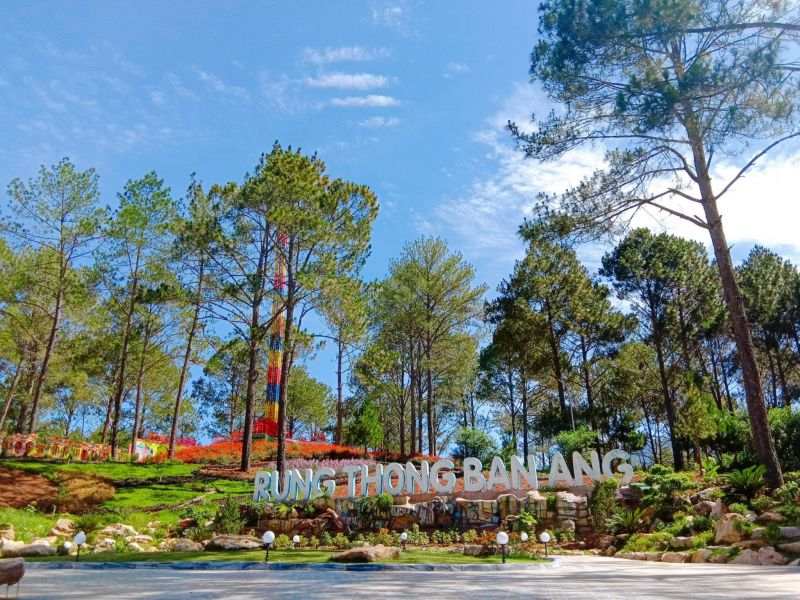
Moc Chau has long been considered a paradise land for those who love nature, seek a fresh, cool climate, and stay away from all the noise and bustle of the bustling city. Tourist destinations in Moc Chau always bring poetry and charm, making everyone who sets foot here feel nostalgic. Among them, the appearance of Ban Ang pine forest promises to bring clear blue colors amidst the majestic and vast Northwest mountains and forests. Ban Ang pine forest is a place located in the Ang village area of Dong Sang commune, Moc Chau district, Son La province. Possessing a total area of about 43 hectares, this place includes a towering green pine forest, stretching across red-brown hillsides, and accompanied by a clear lake of up to 5 hectares wide. , has become an extremely new camping destination for tourists in the North. The most ideal time that you can choose to visit this Ban Ang pine forest is from January to March. At this time, the weather in Moc Chau is often cold, with light fog, along with It is filled with flowers stretching all over the road, creating extremely favorable conditions for you to take "extremely chill" check-in photos as well as admire the poetic natural scenery in the area. this area. Coming to Ban Ang pine forest, you will admire the Chimi strawberry garden carefully and meticulously cared for by the skillful hands of the local people here. This strawberry garden always brings a sweet fragrance that spreads throughout the entire garden, making you feel surprised and fascinated when you set foot in this area. Besides, you will also enjoy fresh strawberries with a blend of sour and sweet flavors, bringing wonderful, cool refreshing feelings as if you are lost in the flower city of Da Lat. . Besides, Ban Ang pine forest is also an ideal place for you to admire the shimmering, seductive colors of Moc Chau plum blossom season in the early spring months, from January to March. With the combination between the freshness of nature, and the fresh, iridescent but no less poetic colors of plum blossoms. All have created the brilliant colors of a pine forest that brings many different emotions of nature amidst the vast and majestic Northwest highlands. Along with the surrounding green pine forest and fresh, cool atmosphere, Ban Ang pine forest is an absolutely indispensable destination for you to organize camping trips in this area. There are quite a few vacant lots here so you can freely choose the most suitable spot to set up your tent, organize grand BBQ parties, and light a campfire with your friends, enjoying the wind. of the vast Northwestern mountains and forests. It can be said that Ban Ang pine forest is not only a place containing the inherent natural colors of heaven and earth, but also a paradise land of interesting experiential activities, for those who are passionate and want to Immerse yourself in the fresh, cool atmosphere, and admire the lush, green nature. This tour in the pine forest will definitely leave unforgettable memories in your mind.
Son La 982 view
From January to March.
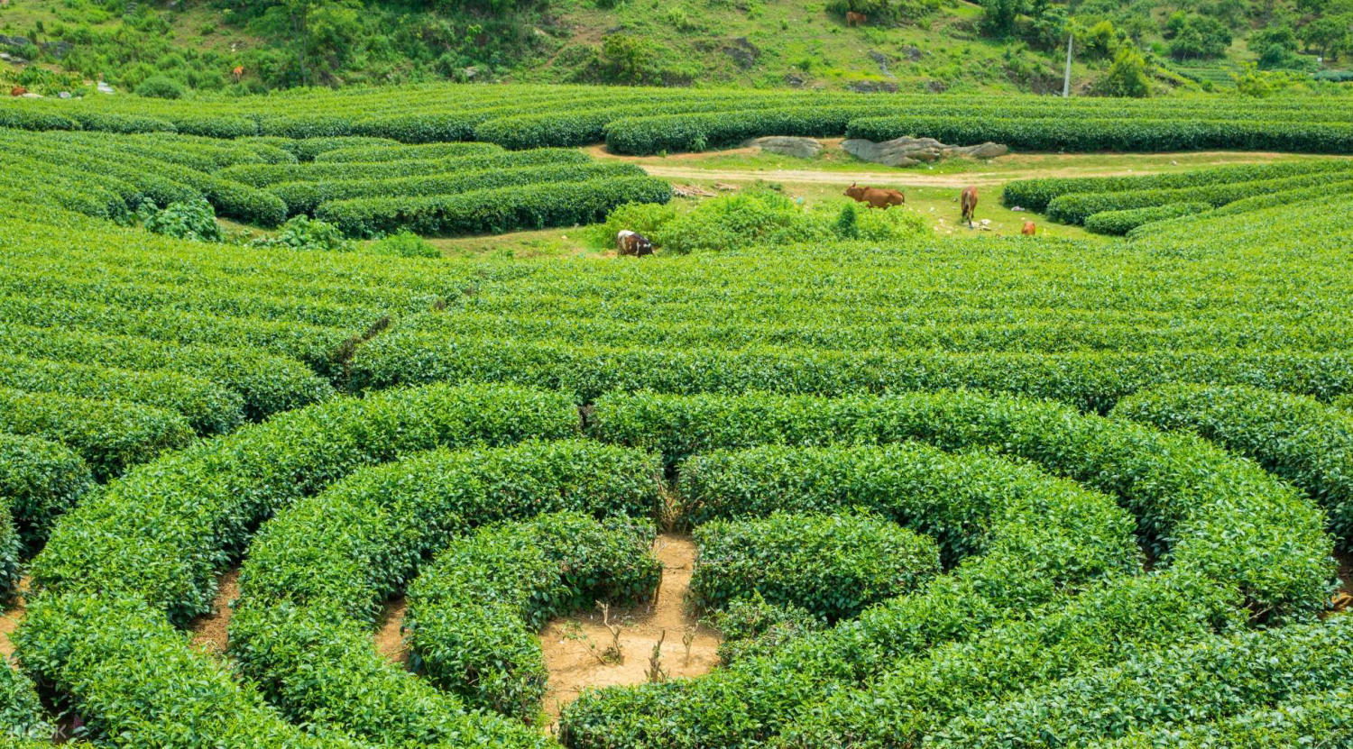
Not only famous for possessing green space and diverse ecosystems, Moc Chau is also known for its many large green tea hills. In recent years, Moc Chau tea hill has become a tourist destination attracting many visitors and is no longer simply a place where regular tea is harvested. If you have a lot of time, you should explore all the tea gardens here and keep memorable moments for yourself. Tourists visiting this green land covered with tea not only get to see impressive scenery. Besides, you also have the opportunity to try other interesting activities such as check-in, sightseeing or interesting tea leaf picking. Known as famous tourist destinations in the Moc Chau area, Taiwanese tea hills always impress visitors because of their impressive and green appearance. Currently, the tea hill is located in On village area, Nong Truong town in Moc Chau and about 10km from the center. Because it is a joint venture farm with Taiwan, this place is also known as Taiwan's heart tea hill. The space of the tea hill is not only covered with a fresh green color combined with the natural fresh air color of Son La land. In particular, it must be mentioned that the new and innovative design helps this place gain an interesting highlight in the eyes of visitors. In addition, this also creates a lot of joy for people during the tea harvesting process. With its impressive natural beauty and romantic shape, it symbolizes couples, as well as lasting love. Taiwanese tea hills have been chosen by many couples and couples to visit and check-in with an extremely unique and romantic background. In general, the weather in Moc Chau is quite cool and somewhat colder than other provinces in the Northern region. With the characteristics of 4 seasons: Spring, Summer, Fall, Winter and fresh atmosphere, visitors can visit the heart tea hill at any time of the year. However, one piece of advice for you is to consider coming to Moc Chau in March - April. Because at this time the weather is warm and sunny and convenient for sightseeing, and young tea buds also appear. The garden should look greener after the first tea harvest of the season. If you love romantic beauty and want to admire the blooming apricot and plum flowers, January - February is also ideal for a visit. One of the points that helps the tea hill in Moc Chau become attractive to many young people today is the clear green space and extremely "genuine" background for people who like to check-in. In particular, in March - April, young shoots appear, creating an impressive, lush green garden. Besides, the unique and romantic heart shape creates a unique attraction for visitors. This includes couples who want to preserve memorable memories, as well as prove their evergreen love. Depending on each visitor, they can bring their favorite clothes, or rent ethnic clothes in the area near the tea hills to take photos. Characterized by the cool weather of the North and many trees, Moc Chau's heart tea hill always gives tourists a feeling of relaxation and closeness to nature when visiting. Different from the crowd and bustle of the district center, this place always has a peaceful, gentle but no less romantic beauty. Coming to the tea garden in Moc Chau, visitors will see the authentic scene of people harvesting green tea leaves. Thanks to that, you can better understand the value of tea leaves and the enthusiasm of the people when harvesting each fresh green tea leaf. At this time, you can also understand more about the life and culture of the indigenous people, and participate in the exciting tea picking activity. One of the strengths that helps the tourism industry in the Moc Chau - Son La area develop, as well as many people come to the tea hills to visit, is the diverse cuisine of this land. Tourists can find many delicious specialties prepared uniquely and differently by the people here. Among them, we can mention some of the following famous dishes: Veal chao, nam pia, salmon, snakehead fish vermicelli, Suoi Bang stone snail, fresh cow's milk, mustard greens,... Each dish is served with different ingredients. Fresh ingredients are easy to find locally, or grown directly and hygienically. Combined with the ingenuity of the people here, creating a unique flavor that is unforgettable from the first time you enjoy it. Every season, the Moc Chau plateau seems to be replaced by a new layer of clothing, but the green color of the tea hills is still there, as if immortal, as if eternal. Once you come to Moc Chau - the land of flowers, don't forget to stop by the tea hill to feel the pure and wonderful beauty of this place.
Son La 927 view
From January to April.

Ta Xua is more than 10km from the center of Bac Yen highland district, the climate is cool all year round. This place is not only known for its ancient Shan Tuyet tea trees and the extremely unique hand-picking of tea of the Mong people, but is also famous for its sea of white, floating clouds that attract tourists. Visitors come to visit, experience and admire the magnificent natural beauty. Located at an altitude of 1,500m - 1,800m above sea level, Ta Xua commune is often covered by rolling clouds, layer upon layer like waves. In the early days of December, low temperatures, high humidity and mild sunshine are ideal conditions for tourists to "hunt clouds" in Ta Xua. We strolled to visit Gio peak, Chung Trinh village, Ta Xua commune, which has a panoramic view of the beautiful valley and the sea of floating clouds. This place still retains many wild features; People's lives are simple and peaceful; Even phone signals are limited, so when coming here, in addition to relaxing and hunting clouds, visitors will be immersed in nature, majestic mountains and forests; Explore and learn about the cultural identity of the Mong ethnic people. To "hunt clouds", visitors must wake up early in the morning to watch the streams of white clouds rising from the foot of the valleys, filling the vast space. The special natural phenomenon has created the scenery here into an extremely magnificent painting, giving tourists impressive names such as "Ta Xua Sea of Clouds" or "Ta Xua Cloud Paradise". There are many "cloud hunting" moments during the day, but the most beautiful are at sunrise and sunset. Waking up early in the morning, visitors can enjoy the quiet space, watching the pure white clouds floating halfway up the mountain. When the sun's rays shine, the clouds gradually disappear, revealing a sky high, blue sky. Sunlight shines down on the valley of dense clouds below. Wherever the sunlight shines, the clouds quickly dissipate, revealing the pristine village of the indigenous people. Just a few seconds ago, the whole valley was still engulfed in mist, suddenly glowing brightly under the sunlight and deep blue sky. When sunset falls, the last rays of sunlight shine through the clouds, creating a space with extremely impressive pink and orange tones. Because of that poetic beauty, Ta Xua this season is attracting a large number of photographers and young people who love to explore and adventure. Tourists are truly satisfied with the wonderful scenery of the "sea of clouds" in the mountains and forests of Bac Yen. The most impressive thing is when the sea of dense, white clouds floats right under your feet, after a strong wind blows the clouds over the mountain slopes, covering the forests and villages, it is really interesting. I took many beautiful moments to preserve memories of this peaceful land and will definitely return to this place many more times. Places such as Ta Xua junction, Gio peak, Ta Xua commune center, Dolphin's peak, lonely tree... and cafes are also the "coordinates" that many tourists choose as places to "hunt clouds". "ideal. Enjoying a cup of Ta Xua specialty tea that radiates a sweet aroma, visitors are captivated by the poetic beauty amid the vast "sea" of clouds with waves of clouds hitting the mountainside. The image of white clouds, sometimes dense, sometimes drifting lazily, is very interesting, giving the feeling of being immersed in the clouds and sky, immersing yourself in the nature of the mountains and forests. Furthermore, enjoying a cup of Ta Xua tea in an airy space, with the cold weather, feels extremely comfortable and peaceful. With fresh air, majestic natural scenery, beautiful like a "fairyland", and friendly smiles of gentle and hospitable indigenous people, "Ta Xua Cloud Paradise" has been and continues to be. becoming an attractive destination for tourists on their journey to Son La and the Northwest.
Son La 951 view
From October to April.


 vn
vn en
en ja
ja ko
ko zh
zh VIP member benefits