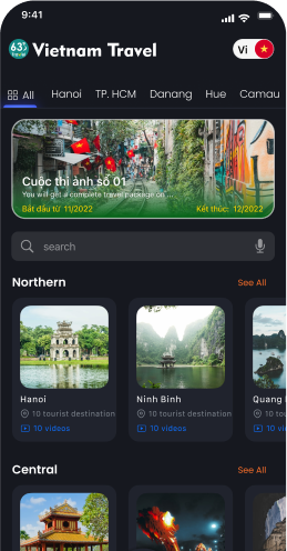
Explore the history, culture, people and beautiful landscapes of Vietnam on the 63Stravel travel app
Download the 63stravel app


Ngoc Linh Mountain

Kon Tum 1103 view
Download the 63Stravel app to watch video reviews without ads


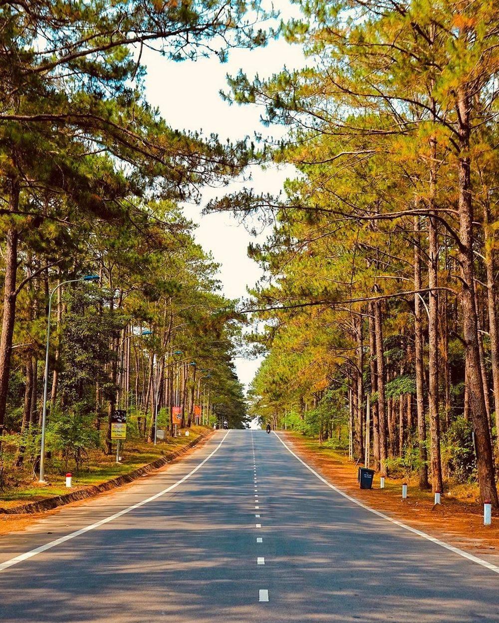
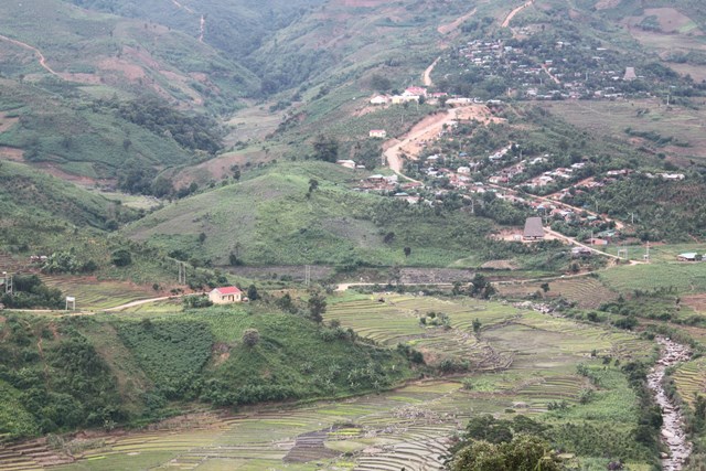
Mang Den pine forest located in the town of the same name, Kon Plong district is one of the famous natural tourist destinations throughout the world. With an area of up to 140,000 hectares, this eco-tourism area is located about 54km from Kon Tum City center, equivalent to 2 hours of travel. The forest is located at an altitude of 1200 meters above sea level, so the climate here is cool and pleasant all year round, extremely suitable for exploration and relaxation trips. Every year this place and its peaceful scenery attract millions of visitors besides other stops in the Central Highlands such as Chu Hreng Mountain, Dak Bla River, Dak Ke Waterfall, Charlie Hill (Sac Ly Hill). ... The first impression when visiting the Mang Den pine forest is the vast green natural scenery covered by a shimmering, fanciful mist and wind here. For a clearer experience, you can completely cross the winding paths while enjoying the fresh air, the smell of pine resin and fragrant flowers while admiring the beauty of this natural forest. Coming to admire the sunrise or sunset of the mountain town, the space of Mang Den pine forest tinged with the magical colors of heaven and earth makes the weathered beauty of this place even more unique and lively. There's nothing better than waking up early in the morning in a far away place to look for the sun peeking out from behind the towering trees, and in the evening enjoying the "red island" gradually disappearing behind the horizon. Especially stopping at Mang Den pine forest Check-in Kon Tum, you also have the opportunity to visit 7 lakes and three waterfalls with clear flows, white foam all day and night, this place is extremely majestic and beautiful. . Thanks to such natural wonders, Mang Den pine forest has fresh, cool air all year round and is known as Da Lat or Tam Dao of this land. In addition, the experience of exploring the villages and customs and traditions imbued with the culture of each ethnic minority living in the Central Highlands will certainly attract you from the first visit. Bringing you a special, unforgettable experience here.
Kon Tum 1798 view
From January to December
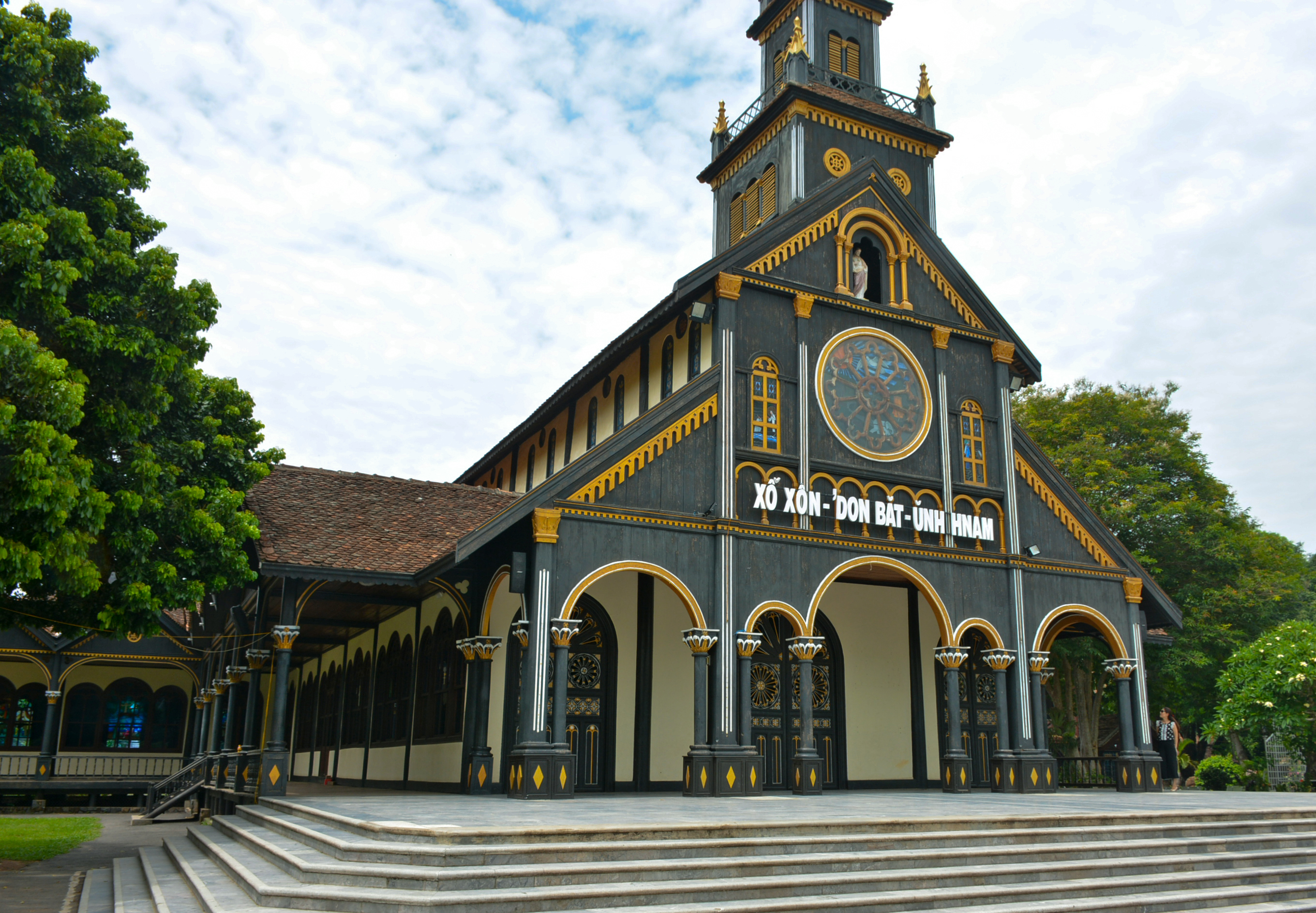
Kon Tum Cathedral wooden church - a treasure located in the middle of the vast mountains and forests of the Central Highlands, is a very unique religious architectural work that is up to centuries old, and is the pride of Kon Tum people for generations. . The church is located on Nguyen Hue street, Kon Tum city, Kon Tum province, built in 1913, completed in 1918 and still exists today. Kon Tum Cathedral was designed and initiated by a French priest. The church's architecture is designed in harmony between Roman architecture and the wooden stilt houses of the Ba Na people. A unique combination of Western culture and online culture imbued with the national identity of the Central Highlands region. The materials used to build the church are also very special, not made of stone like Phat Diem stone church (Ninh Binh), nor made of bricks or reinforced concrete like other churches, but completely made of the best wood. at the time. Ca chit (red bamboo) - a typical wood of the Central Highlands used mainly in the construction of churches. Through the skillful hands of artisans from Binh Dinh, Quang Nam, Quang Ngai... the project was erected, the wooden panels were glued together with tenons without using nails. The church is the only remaining Basilica-style wooden masterpiece in the world. The entire church is a closed building with a harmonious layout including: synagogue, reception house, exhibition house, communal house, orphanage, carpentry facility, sewing facility, and brocade weaving facility. The church is always open for visitors to visit every day. In the campus there is a statue of Bishop Martial Jannin Phuoc - the first Bishop in Kon Tum. This is a French bishop who made great contributions to evangelization and the establishment of the Apostolic Diocese of Kon Tum. Outside, the main face of the church is 24m high, divided into four floors, the higher it gets, the smaller it becomes. The second floor has glass frames forming circular windows, creating a brilliant look for the church. At the top is a wooden cross showing the majesty of the cathedral. Entering the cathedral, you will feel admiration for the people who built this masterpiece. The rows of columns are connected together by arcs to form a dome shape, opening up a wide, high and airy space. The glossy black wooden pillars are decorated with many unique motifs, imbued with the cultural identity of the sunny and windy highlands, bringing a very close feeling. On the second floor of the cathedral, there is a traditional room that stores artifacts, autographs, and documents recounting the history of the missionary process in Kon Tum from the second half of the 19th century and the development of religion to this day. You can come to explore this unique church at any time of the year. If you come during the pea flower blooming season, you will see the pink mixed with white colors of the long flower paths. If you come during Christmas, you will be immersed in the bustling atmosphere when thousands of parishioners from all over the region gather here to celebrate and pray. During the holidays, small markets also take place, selling handicraft products made by people from the villages. If you go to church on normal days, don't be sad, you will feel the peace and quietness that has something very unique, making your soul more relaxed after the chaos of life out there. After centuries, the church still stands proudly despite the storms and rain, like the indomitable spirit of the people of the Central Highlands. This is definitely an attractive tourist destination that you cannot miss when coming to Kon Tum.
Kon Tum 1700 view
From January to December
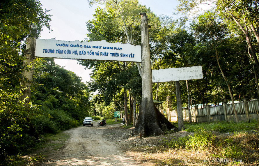
Coming to Kon Tum, don't forget to visit Chu Mom Ray National Park where there is a rare and diverse ecosystem of flora and fauna. This place is probably one of the interesting places to visit that helps visitors have experiences close to nature. At the same time, you can also explore the beautiful scenes of "mother nature" and learn more about the extremely diverse ecosystem here. Not only that, visitors can also learn about the cultural identity and cuisine of the indigenous people of this great Central Highlands region. Chu Mom Ray National Park is located in the North of the Central Highlands in Kon Tum Province. This is considered a transnational biological reserve because it borders both Laos and Cambodia. The West borders Virachey National Park of Cambodia and the Northwest borders the Southeast Ghong Conservation Area of Laos, which is the touch point of three countries, so many people call it a transnational conservation area. The area of this entire area is estimated to be up to 700,000 hectares with a diverse biological system, so it is of special importance to the biological conservation of Indochina in general and Southeast Asia in particular. With a rich and diverse biological system, in 2004 Chu Mom Ray National Park was recognized as an ASEAN heritage by the Association of Southeast Asian Nations. From May to November, this time it rains often, the roads are slippery and difficult to move. On the contrary, in the dry season, the weather is cool and the roads are easy to travel, especially in February and March, when wildflowers bloom on extremely beautiful roads. On this occasion, there are also many festivals of indigenous people taking place, so perhaps coming on this occasion you will have the most complete journey possible. Chu Mom Ray National Park not only has an extremely diverse ecological system, vast mountains and forests, interspersed with numerous systems of rivers, streams, and waterfalls. Perhaps that is why more and more people come to visit, explore, immerse themselves in nature and enjoy the mountain atmosphere. Ja Book Valley is located deep in the "old forest" and has an area of up to 16,000 hectares. Previously, this place was a vast green grassland, a place where many species came to find food and shelter such as Indochinese Tiger, Gaur, Wild Buffalo, Wild Boar,... but now there are only about 6 hectares of grassland, the rest is heavily invaded by a type of thorn bush. Compared to before, the number of animals residing here has decreased significantly. Visiting here, visitors can see wild animals such as wild boar, wild buffalo... coming in search of food and water. Chu Mom Ray National Park includes many types of terrain, hills, valleys,... so there are many interlaced systems of streams, thus creating conditions for the formation of magnificent waterfalls. The 7-storey waterfall is a famous landmark located within the Chu Mom Ray National Park campus. The flow from the top of the waterfall, dozens of meters high, flows down step by step, creating an extremely impressive and eye-catching scene for onlookers. The lush green mountain scenery mixed with the rolling waterfall seems to create a masterpiece of nature, an extremely vivid mountain and water painting. Chu Mom Ray National Park is home to a number of ethnic minorities such as: Ro Mam, Ba Goc, Bo Rau, H Lang, Gia Rai, Ko Dong,... including the Bo Rau ethnic group. the smallest ethnic group among the 54 ethnic groups. Visiting villages of ethnic minorities, people also have the opportunity to experience and learn more about the unique culture of the indigenous people. In addition, you can also enjoy specialties made by indigenous people, and rest in communal houses or public houses of the people here. If you have the opportunity for a long trip, choose a suitable itinerary to visit Chu Mom Ray National Park and visit many places in Kon Tum. Some suggested places for tourists to refer to include: Yaly Waterfall, Ho Chi Minh Trail, Bo Y international border gate, Kon Klor Communal House, T'Nung Lake,...
Kon Tum 1797 view
February to March
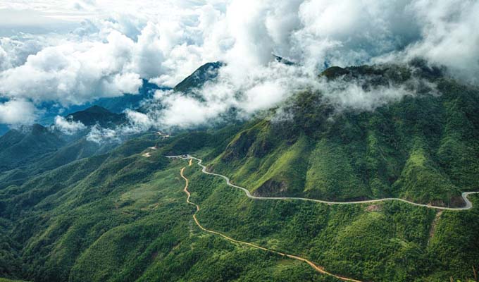
Stretching across the four provinces of Kon Tum, Quang Nam, Quang Ngai and Gia Lai, Ngoc Linh Mountain, also known as Ngoc Linh Lien Son, is one of the highest and most massive mountain blocks in the Truong Son range next to its brothers. such as Ngoc Phan Mountain, Muong Hoong Peak, Ngoc Lum Heo or Ngoc Bon Son. The stopping place is covered by a layer of magical white clouds with the legendary Dak Bla River running across, making everyone watching from a distance unable to help but be captivated by the majestic natural beauty. As a sacred mountain located in a sacred land of convergence, Ngoc Linh attracts millions of visits every year, of which the most prominent is certainly the adventurous conquering of skyscraper peaks. Although Kon Tum's climate is cool all year round, in general the best time to check-in to Ngoc Linh Mountain is from December to March of the following year, when the weather is fresh, airy, sunny and extremely sunny. rain. Because the trekking route is particularly steep and dangerous, this is a prerequisite with an experienced guide and professional climbing support tools to start the journey to discover Ngoc Linh Lien Son. You can visit in the last two months of the year, December and November, to watch wild sunflowers bloom brightly during the trip or enjoy the scenery of rubber forests in the changing season of leaves in January, coffee hills with small flowers. Tiny, pure white brightens up the entire sky in March. All of them promise to bring you memorable travel moments. Ngoc Linh Lien Son block is located adjacent to Quang Nam and Kon Tum, so in general, travelers starting from Saigon who want to go to this place can stop at one of the two provinces mentioned above with a variety of means of transport such as Plane, bus, limousine... Normally, a bus from Ho Chi Minh City to Kon Tum will cost from 200,000 VND to 300,000 VND/one-way route, however the journey takes quite a long time (nearly 14 hours). You can consider booking a limousine ticket from Phong Phu, Tan Anh or Truong Giang with the expected cost of about 400,000 VND to 600,000 VND/one-way trip if you want a comfortable and convenient long-distance travel experience. most suspicious. This is also a type that is very popular with friends near and far when they have the opportunity to travel to Kon Tum. After arriving at these two provinces, the traveling association just needs to take a taxi or rent a car or motorbike to get to Ngoc Linh Mountain. For you to stop in Kon Tum, here is the easiest and most popular backpacking route to the mountain that you can refer to: From the center of the mountain town, people follow National Highway 14 to DT672 road. belongs to Tu Mo Rong district. After going towards DT673 about 34km, you will be greeted by Ngoc Linh Nature Reserve - where Ngoc Linh Lien Son is located. Although the whole journey may take about 2 hours to travel, in return you will have many opportunities to admire and explore impressive scenery. Among the interesting activities here such as visiting Chu Mom Ray National Park, exploring Mang Den Pine Forest, perhaps conquering Ngoc Linh Mountain is an extremely attractive experience when having the opportunity to visit the land of Kon Tum. this spirit. With a height of more than 2,500 meters above sea level, to climb the mountain you must first start from small, winding roads that are difficult to get to the cliffs and extremely dangerous cliffs. Next is to cross the streams of water flowing through the rocks creating a gurgling sound imbued with the majestic nature and cross the primeval forests stretching for kilometers with a variety of rare and hard-to-find creatures. With every step you take to explore, the wild landscape that appears here will make you curious and excited. The most memorable is definitely the feeling of walking through the walls of leaves that seem to be silently covering and protecting this sacred mountain while opening the way upward. The air is cool at first, then gets colder and colder, showing that the traveler is getting closer to the clouds floating on Ngoc Linh peak - the place where many mysteries are hidden. It is the rugged roads, dangerous green forests and countless fast-flowing streams that create a welcome challenge for adventure enthusiasts when setting foot on this mountain.
Kon Tum 1912 view
From January to December
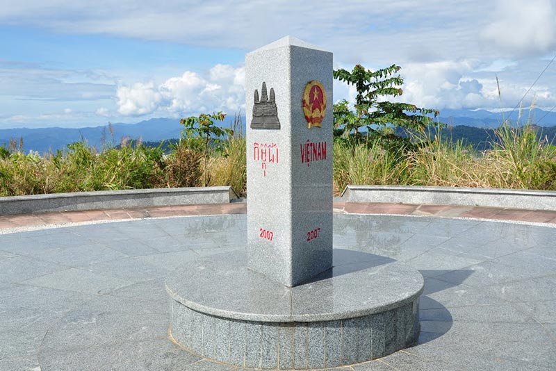
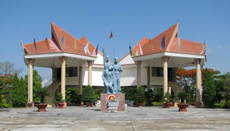
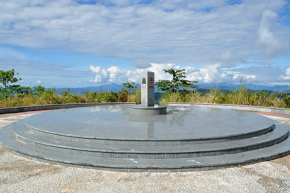
The place of the Indochina junction on the majestic Truong Son range has always been in the memories of soldiers and young volunteers on their way to the Southern battlefield, battlefield C (Laos), battlefield K (Cambodia) over the years. Unforgettable war. This is the land known as the rooster crowing that all three countries hear together. Now this land is becoming one of the attractive tourist destinations for domestic and foreign tourists. Places where places have gone down in history such as the Indochina junction (where Truong Son West road meets Truong Son East road during the resistance war), historical relics of the victory of Dak To - Tan Canh in April 1972; The border marker was jointly built by the three brother countries Vietnam - Laos - Cambodia on a mountain top 1,000m above sea level, about 30km from Playku town. This milestone was constructed by Kon Tum province in December 2007 under the supervision of experts from three countries sharing a common border. Representatives of the three countries' Ministries of Foreign Affairs held a solemn inauguration ceremony on January 18, 2008. The special milestone weighs 900 kg, is made of triangular cylindrical marble, is 2 meters high, and on each side of the milestone facing each country is attached the national emblem, the year the milestone was installed and the country's name in red letters of the government. that country. This is the second milestone marking all three countries to be placed on Vietnamese soil. The first milestone is the unified construction of the three countries Vietnam - Laos - China in A Pa Chai (Dien Bien).
Kon Tum 1810 view
From January to December
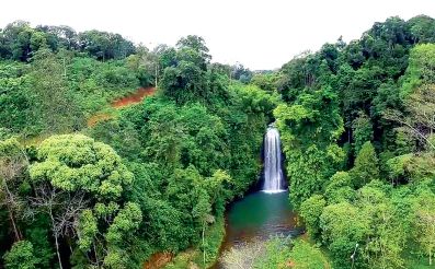
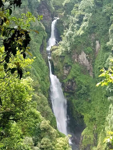
Pa Sy Waterfall is a prominent landmark in the romantic Mang Den land, associated with the legend "Seven lakes, three waterfalls" a story of the Mo Nam ethnic people, when in the past, violating heaven's prohibition, all 7 villages were punished. sink into a sea of flames. Later it turned into 7 lakes and 3 waterfalls. Among the three majestic waterfalls, Pa Sy waterfall is the largest waterfall in the region. The name Pa Sy was born due to a deviation from the original name of the Pau Suh people, meaning "three streams gathered together". With two distinct seasons: the rainy season and the dry season, you should choose the appropriate time to visit the waterfall. According to experience traveling to Pa Sy waterfall, the dry season around October to April of the following year is the ideal time. ideal to visit the majestic waterfall. At this time, the dry weather is favorable for traveling, participating in outdoor activities and participating in festivals. This is also the season when ripe rice blooms and turns golden in all corners of the road near the waterfall. Coming to the waterfall in the dry season, you will admire the majesty of the waterfall. At this time, the clear blue water creates a truly lyrical scene. In the dry and hot dry season, coming to the waterfall area will cool you down, giving you a very pleasant feeling. Pa Sy Waterfall is located in the Pa Sy Waterfall cultural eco-tourism area, located in Mang Canh commune, Kon Plong district, Kon Tum province. With a total area of up to 25 hectares, the tourist area stands out with the green of nature, like a giant garden of Eden. To get to the waterfall, you can choose a bus or plane to travel. If you feel suffocated with current life and want to find a peaceful place to relax, gather with friends, relatives and have fun to recharge new energy, then Pa Sy waterfall eco-tourism area would be a reasonable choice. It only costs you less than 100,000 VND/person to have fun here. Pa Sy waterfall in Kon Tum is famous for its water flowing from a height of more than 1,500m with white foam, both majestic beauty and poetic and rustic features. The turquoise waterfall and lake are surrounded by majestic primeval mountains and forests, creating a fresh water picture like a fairyland. On hot summer days, the cool waterfall will help relieve the heat, wash the soul, and help visitors enjoy the most relaxing and comfortable feeling. In the lush natural scenery, dotted by a white waterfall like a silk strip across the sky, coming here you will take many beautiful photos. Let's make memories with friends and relatives at this fairyland. In addition, visitors can also participate in the special festivals of the Ro Mam people held annually such as the Rice Sowing Festival, new rice celebration, the buffalo barn worshiping festival, burial customs,... So Be sure to find out the festival time before arriving. Coming to the tourist area, you will not only admire the beautiful scenery at the waterfall, but this is also an opportunity for you to enjoy delicious Central Highlands specialties. It's great to rent a tent with friends to hold an outdoor BBQ party, enjoy coffee and watch the mountains and hills, amidst the majestic landscape, with a few scattered roofs and stilt houses appearing under the garden. Coming to the Pa Sy waterfall cultural eco-tourism area, visitors also have the opportunity to admire 100 wooden statues, vividly showing the daily lives of people here, and is also an opportunity for you to understand more about national culture. A few notes below will help make your visit to Pa Sy waterfall more complete. Plan your trip early to have the most complete arrangements and preparations. To be proactive in transportation, motorbikes are the preferred means of choice. You can easily rent motorbikes in the Mang Den or Kon Tum area for 120,000 VND/day. Experience renting a house in the form of a homestay, to enjoy a poetic space, and learn more about the lives of the people here. Combine tourism at locations near Pa Sy waterfall such as Dambri lake, Khanh Lam pagoda,...
Kon Tum 1763 view
October to April
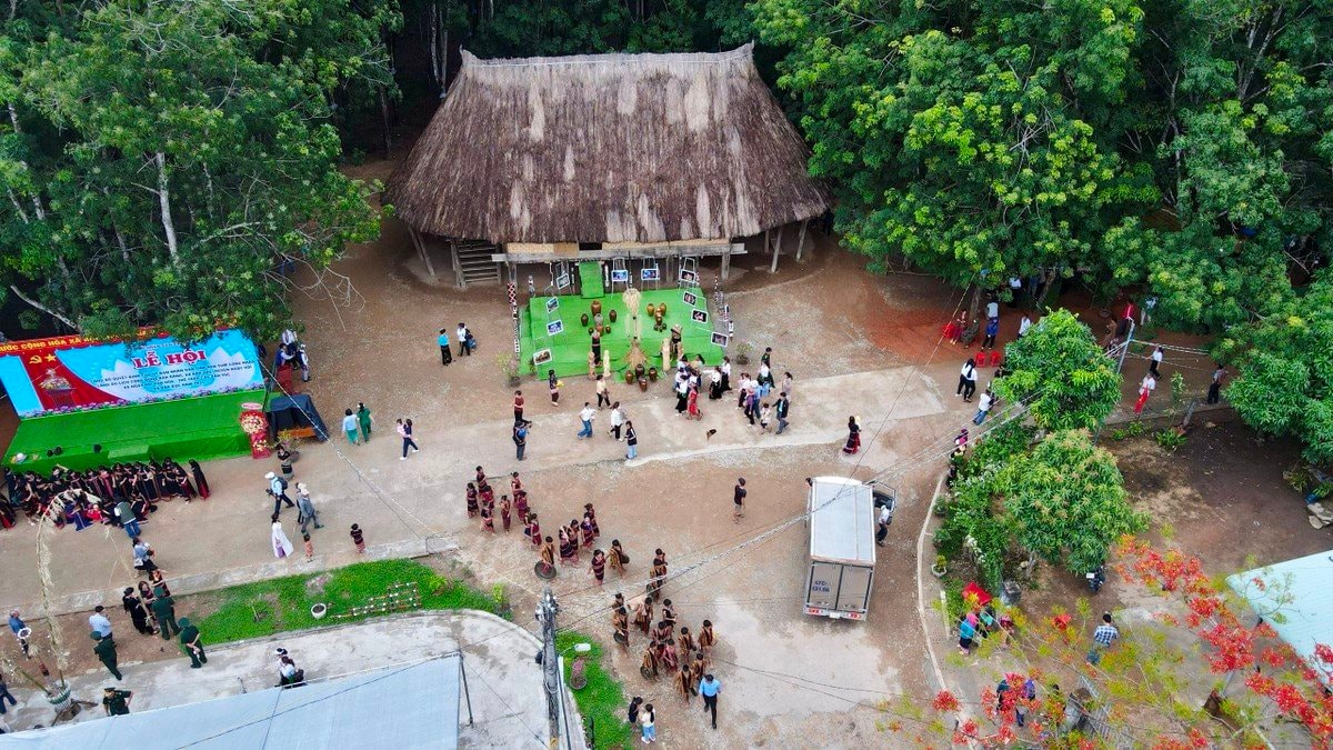
Dak Rang Community Culture - Tourism Village, an ideal destination for you to experience Gie Trieng culture, explore the nature of the Central Highlands and enjoy moments of peace and relaxation. Community Culture - Tourism Village Dak Rang, located in Dak Rang commune, Ngoc Hoi district, Kon Tum province, is an attractive destination for those who want to explore the uniqueness of Gie Trieng culture and immerse themselves in the wild, majestic nature. With 99% The population is Gie Trieng people, Dak Rang retains all its unique traditional cultural features. Coming here, you will be immersed in a rich cultural space, visit traditional communal houses, learn about brocade weaving, and enjoy typical dishes such as bamboo-tube rice, grilled chicken, and can wine. .. and participate in traditional festivals and rituals such as the new rice celebration, the forest god worship ceremony... The village also has a display house introducing traditional cultural products of 17 ethnic minorities in the area. Ngoc Hoi district, helping visitors better understand the rich cultural and spiritual life of ethnic minorities in the Central Highlands. Dak Rang community tourism village is invested in quite synchronous infrastructure, with electricity systems, clean water, community motels, rest stops, signposts... Visitors can choose to stay at homestay to experience the daily life of the Gie Trieng ethnic people, or participate in nature exploration activities such as trekking, mountain climbing, stream bathing... Come to Dak Rang Culture - Tourism Village, Kon Tum , you will experience the indigenous life of the Gie - Trieng people, immersing yourself in a unique traditional cultural space. Try sleeping one night in a typical stilt house, feel the warmth of an open fire and listen to thrilling stories told by village elders. Early in the morning, wake up to the sound of roosters crowing and join the people in the fields to work, learning how to grow crops and raise livestock in the traditional way. In the afternoon, you can participate in community activities such as brocade weaving, pottery making, knitting... and learn about the unique art of gongs. In the evening, gather around the fire, enjoy specialties such as bamboo-tube rice, grilled chicken, wine... and immerse yourself in traditional music and dance performances, and cultural exchanges with the people. . Let's start by visiting the Rong house, a community center, with unique architecture and sophisticated patterns. Next, you can visit the exhibition house, where artifacts and images introduce the history and culture of the Gie - Trieng people. Don't miss the opportunity to admire colorful traditional costumes, solemnly displayed gongs and learn about exquisite brocade weaving. You can also participate in cultural activities such as gong rituals, a unique cultural feature of the Gie - Trieng people, recognized by UNESCO as an Intangible Cultural Heritage of Humanity, learn how to Weaving, weaving or pottery with local people. In the evening, gathering around the fire, sipping a warm glass of wine and listening to the legendary stories of the Gie - Trieng people will be a memorable experience. From Dak Rang Culture - Tourism Village, you can start your trekking journey to explore the majestic natural landscape of Kon Tum land. Following the trails weaving through the jungle, you will immerse yourself in pristine nature, breathe fresh air and listen to the sounds of the mountains and forests. Along the way, you will encounter gurgling streams, white waterfalls pouring down from cliffs, towering ancient trees and lush green vegetation. Don't forget to bring a camera to capture beautiful moments of nature. If you are lucky, you may encounter wild animals such as monkeys, squirrels, birds... Observe them from a distance and do not disturb their habitat. Trekking in this area is not only a fitness activity but also an opportunity for you to explore the hidden beauty of the Central Highlands mountains and forests and enjoy moments of relaxation and immersion in nature.
Kon Tum 1203 view
From December to May
Siu Puong Waterfall is one of the famous places when traveling to Kon Tum that is loved by many young people. The waterfall is located halfway across the Van Peo mountain range in the north, in Dak Na commune (Tu Mo Rong district). Coming to Siu Puong waterfall, in addition to admiring the beauty of the vast and rich mountains and forests, you will also hear mysterious and fascinating stories about the waterfall told by local people here or eat special dishes. only here. Siu Puong Waterfall is also known by the familiar name Da Floor Waterfall. This is a very suitable place for backpacking enthusiasts. The waterfall is located about 42 kilometers from Kon Tum city. To get to the waterfall, you just need to go along Provincial Road 672 about 16 kilometers past the intersection of Dak Tram market, then turn left onto Provincial Road 678 about 30 kilometers more to reach the center of Dak Na commune. From the center, continue traveling for about 20 minutes by motorbike and you can reach the waterfall gate. In order for friends near and far to be able to access the waterfall, many villagers in Dak Na commune have cleared trees, built and expanded walking paths to the waterfall. From the foot of the waterfall, you walk about 1,500 meters to reach the top of the mountain. With many lakes and rich vegetation, Siu Puong waterfall is very suitable for tourist activities of discovery and experience. If the road to Dak Ke waterfall is easy and flat, the road to Siu Puong waterfall will be more winding and winding. However, this will be an experience worth trying for those who are passionate about backpacking and self-sufficient travel. On the way, you will admire the vast terraced fields, with a winding stream flowing through the middle of the fields, looking very poetic. Siu Puong Waterfall is a waterfall that is highly valued by indigenous people. Like the Mang Den pine forest, the waterfall is said to be a spiritual place and has a very sacred water source. People use this water source for daily activities and strictly prohibit activities that pollute the water source such as washing at the source. Menstruating women are not allowed to wade through the waterfall's water, even when burying. People who die in the village are not allowed to carry across this water. However, nowadays the customs and taboos at Siu Puong waterfall have gradually disappeared over time. However, for the Xo Dang people living here, the waterfall's water source still has great significance. The waterfall is about 240 meters long, flowing into many different levels from top to bottom. In particular, there are 5 main floors in a zigzag shape, the top floor is about 60 meters high, 2 floors have an average height of about 40 meters and 2 shorter floors have an average height of about 10 meters. Located at an altitude of 1600 meters above sea level and surrounded by old forests, Siu Puong waterfall always has a cool climate and is especially cold in winter. The water of the waterfall is very clear and cool, suitable for you to relax in the hot summer. However, regardless of the season, when you go to the waterfall, remember to bring a jacket to avoid catching a cold due to the cold water emitted from the waterfall. Not inferior to Yaly waterfall, Siu Puong waterfall with its white water color located between four majestic mountains makes anyone who comes here overwhelmed. All create a magnificent but extremely poetic natural scene, Siu Puong waterfall looks like a soft white silk strip standing out against the green background of the mountains and forests. Besides the beautiful natural scenery, when visiting Siu Puong waterfall you will also have the opportunity to participate in the daily activities of indigenous people such as picking wild vegetables and preparing dishes as a living skill. survive when going to the forest. These will be valuable experiences that bring many interesting emotions to your trip. Another impressive thing is that on the journey to discover Siu Puong waterfall, there will be many stops, some empty fields with beautiful streams flowing through. Like Lo Ba waterfall, you can freely camp and rest on these grounds. When camping and resting right next to the waterfall, you will hear the sounds of the vast mountains and forests, of the gurgling stream flowing through the rapids, bringing a strange feeling of peace. In addition, this place also stands out for its waterfall bathing activities. You can wade and soak in the cool water to refresh your spirit. Coming to Siu Puong waterfall, in addition to discovering the beauty of the waterfall, you can also conquer the vast primeval forest and experience the life of the local people here. You can pick wild vegetables yourself, then boil or grill them with stone snails, stream fish, pork belly,... and enjoy right at the waterfall. Many friends who visit also bring grilled chicken, grilled meat, bamboo-tube rice, wild salt and pepper, bamboo-tube grilled meat combined with wild bananas, etc. when coming here. There is nothing happier than enjoying delicious food while admiring the beautiful scenery and breathing fresh air. However, during the process of lighting a campfire or preparing food, you should pay attention to extinguishing the fire thoroughly to avoid unfortunate events such as forest fires. If you have the opportunity to come to Kon Tum, please try it once. Visit Siu Puong waterfall to admire the beauty of this waterfall with your own eyes. This will be an ideal tourist destination for your summer.
Kon Tum 1176 view
From June to October
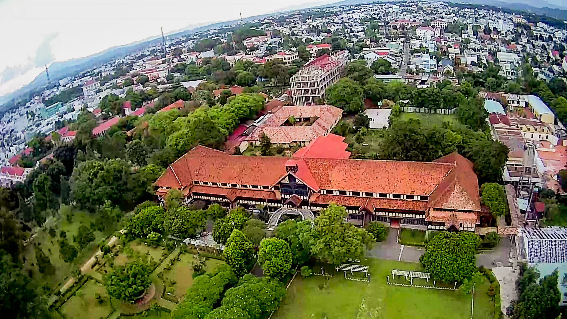
The Kon Tum bishop's house is not a place to honor a specific type of belief, it represents the diversity of beliefs and cultures of the Kon Tum area. The bishop's house is meant to show harmony and respect between the different religions and beliefs in this area. In addition, the bishop's palace also has unique architecture and is an important historical and cultural attraction in the area. Kon Tum Palace is located on Tran Hung Dao street and is an impressive building with unique architecture. unique. The combination of the impressive location among the mountains and forests and the grand architecture of the bishop's palace creates a unique setting. The building spans about 100 meters and has three floors, giving an impressive view of its scale. The beautiful and nature-oriented grounds make sightseeing enjoyable and comfortable. The green and quiet space is probably a highlight of the visiting experience here, allowing visitors to enjoy the natural space and feel the peace of the surrounding mountains and forests. The bishop's palace was built in in 1935 and is one of the important and unique religious works of this area. With the role of managing both dioceses of Kon Tum and Gia Lai provinces, it makes an important contribution to the organization and development of the Catholic community in the Central Highlands region. Bishop Martial Jannin Phuoc is one of the pioneers in building the Kon Tum church. It took 3 years to complete the project, showing his care and dedication in creating a unique and beautiful religious building. The architecture and design of the bishop's palace may have characteristics of French architecture, reflecting the combination of European architectural knowledge and the Central Highlands. Promising to be a place that attracts many tourists who want to explore architecture and beliefs, it is completely suitable when traveling to Kon Tum. Kon Tum Bishop's Palace is not only an important religious building but also a unique cultural and architectural symbol in the region. Visitors can enjoy sightseeing and learn about the history, beliefs and architectural art of this place. The spacious path and front yard decorated with green trees and milk flowers create an enjoyable space, expressing peace and tranquility. The gentle scent of milk flowers along with the shade from green trees is probably part of the enjoyable experience for visitors when they visit the Kon Tum bishop's palace. This creates a relaxing and sacred feeling as you enter the area. Inside there are bedrooms, classrooms, dining rooms, traditional houses... with modern Western style, visitors can experience the traditional space and understand more about the history and culture of this area. Looking straight outside is a green garden with many trees. The lush green garden creates a quiet and comfortable space, allowing visitors to relax and "virtual live" in the natural environment. This makes visiting the Kon Tum bishop's palace more interesting and provides an exciting experience of nature and culture. The traditional house, considered a museum, is a precious place to preserve and display the culture and heritage of the indigenous people of the Central Highlands. Displays of living utensils, farming tools, and exquisitely carved wooden furniture allow visitors to better understand the lives and traditional crafts of the Central Highlands people. If you are passionate about exploring and learning about religion and culture, visiting places like the Kon Tum bishop's palace is an interesting and rewarding experience. This helps you better understand the diversity and depth of religion and cultural heritage in different regions.
Kon Tum 593 view
From November to April
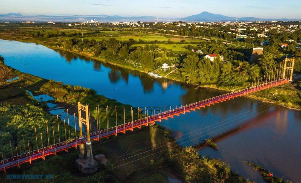
Kon Klor suspension bridge is a very popular Kon Tum tourist destination in Dak Ro Va commune. Not only does it have a beautiful appearance, this is also a unique project associated with the name of the windy highland city. If you have the opportunity to visit here, don't miss the opportunity to check in with this famous bridge! Kon Klor suspension bridge across the Dak Bla river - the legendary river flowing back to the West is the place to check out. -in "virtual living" attracts a large number of people near and far next to Bo Y Border Gate, Long Loi Flower Garden... This famous architectural work that took about 1 year to complete has a similar structure and size. looks extremely impressive. Not only is it the largest and most beautiful bridge in the mountains and forests of the Central Highlands, this is also one of the unique symbols of the highland city of Kon Tum that you cannot miss the opportunity to visit here. Like many other prominent tourist attractions, the best time to visit Kon Klor Suspension Bridge is from December to March of the following year, which falls in the highland dry season. Because at this time, Kon Tum's weather is generally sunny and little rain, so it will be extremely favorable for you to visit, trekking or start a journey of discovery. If you have the opportunity to stop here in the last two months of the year, December and November, besides the cold weather that brings a feeling of relaxation and comfort, you will also be greeted by the stunning beauty of the wild sunflower hills. The area is filled with golden trees and a bustling, cheerful atmosphere coming from countless festivals celebrating the harvest. January when the rubber tree forest enters the leaf-changing season or March when the coffee fields bloom with white flowers filling the sky are also ideal times that you should consider. Officially inaugurated on May 1/ In 1994, after more than a year of construction, the Kon Klor Suspension Bridge stands out with its eye-catching bright yellow and crimson colors and has been in operation for nearly 30 years. This is a large and beautiful architectural work spanning the two banks of Dak Bla - the legendary river flowing to the west of the vast land connecting Quang Ngai province with Yaly Hydropower Plant and Kon Tum commune with the new economic zone. Under the warm afternoon sunlight, this 292 meter long, 4.5 meter wide bridge surrounded by majestic high mountains and sprawling green mulberry fields always makes anyone who has the opportunity to visit this place feel excited. Bewildered by the charming beauty reflecting in the river of the bridge. Not stopping at appearance, Kon Klor Suspension Bridge made of solid iron and steel also has extremely good durability and bearing capacity. With a cable-stayed structure (also known as oblique tension) using pillars and anchor cables to support the entire system, the bridge allows many types of vehicles or vehicles with large loads to move freely without having to move. worry about safety. This is also the unique design that carries the bridge's name far and wide while also turning this project of the proud Kon Klor Village into an aesthetic symbol associated with the era from windy Kon Tum City. Indigenous people after a long day of work crossing the Kon Klor Suspension Bridge returning home with carts full of cassava is one of the extremely familiar images at this attraction. In the past, when the cable-stayed bridge had not been built, both people and cattle who wanted to get to the other side had to wade across the river or row boats, which was both difficult and very dangerous. At present, thanks to the presence of the bridge, the lives of Kon Tum people in general and Kon Klor Village in particular have changed significantly. Food and goods are transported back and forth between the two sides more conveniently. Children cross the suspension bridge in their hometown and freely play on the way to school instead of traveling by wooden boat that sometimes tilts in the strong current. Crossing the other side of the bridge, you can not only visit the Ba Na ethnic village with its unique customs and traditions, but also have the opportunity to enjoy the village scenery covered with immense, low green. In the open are banana gardens and coffee hills, imbued with the wild and majestic Central Highlands. It can be said that this cable-stayed bridge not only brings important connection value, helping to bring closer the distance between people on both sides of the Dak Bla River, but also makes a great contribution to understanding cultural traditions and trade. economy, thereby creating a strong relationship between the ethnic groups living together here. Kon Klor Suspension Bridge - a work that uniquely symbolizes the cultural beauty of the Central Highlands region in general and Kon City in general. Tum in particular. If you have the opportunity to travel to the plateau, don't forget to stop by this bridge to bring home beautiful "virtual life" check-in photos!
Kon Tum 631 view
From November to April
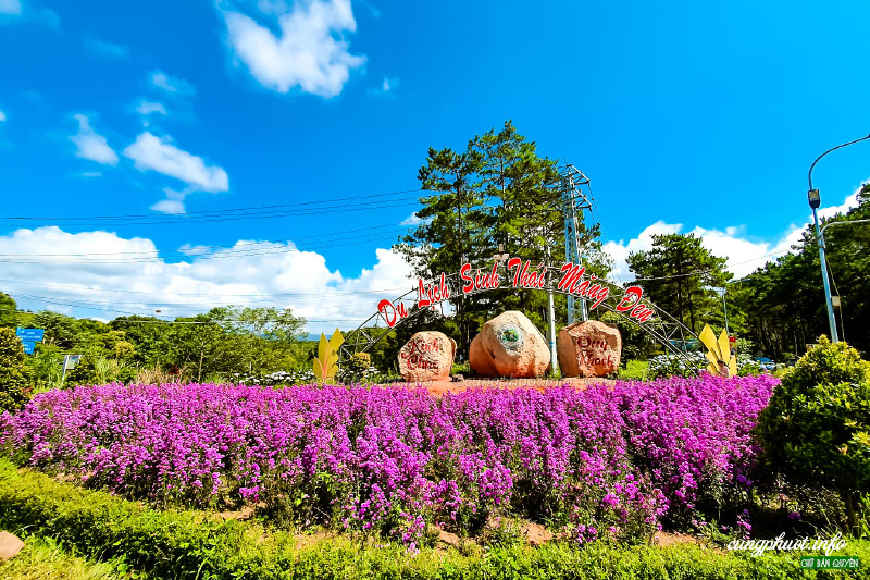
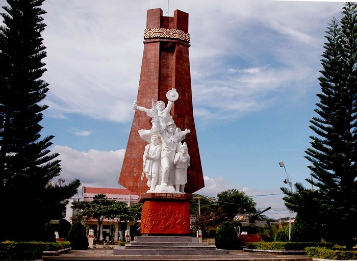
Mang Den eco-tourism area is located in Mang Den town, Kon Plong district, Kon Tum province. Mang Den is a cluster of enemy strongholds, located on Road 5 from Kon Tum to Quang Ngai, now Highway 24, about 55 km northeast of Kon Tum city. This is a cluster of enemy bases deep in our liberated area. Surrounding the base is a complex system of dense obstacles with 10 layers of barbed wire and 2 layers of fence. Alternating between the layers of fence are anti-infantry mines, anti-tank mines and a trough-shaped trench 4m wide, 2.5m deep, densely planted with spikes. Inside were hundreds of blockhouses made of reinforced concrete and earthen wood, with tunnels connecting the fortifications and three corners with three mother blockhouses made of solid reinforced concrete. In mid-1974, the Kon Tum Provincial Party Committee and the B3 Command advocated attacking and destroying enemy bases to expand the liberated area and create momentum for the temporarily occupied Kon Tum area. After a period of preparation, at exactly 5:30 a.m. on October 3, 1974, the Commander of the 28th Infantry Regiment, Division 10, Army Corps 3 ordered to open fire to attack the enemy headquarters. At 7:55 a.m., our firepower simultaneously hit all targets. After a short time of developing the attack, at 10:45 a.m. we completely took control of point M12. Faced with the attack power of the H16 and H29 forces, the main force of the 28th Infantry Regiment and a number of our technical troops, on October 12, 1974, the enemy's last stronghold was located deep in the settlement area. The project in the Northeast of Kon Tum was completely wiped out. With the Mang Den victory in October 1974, our troops destroyed the enemy's last stronghold deep in our liberated area, breaking the enemy's safe corridor in the north of Kon Tum town, causing enemy troops to in the Northern Central Highlands battlefield was under strong threat. This victory liberated thousands of people and a large area of land, which was a great encouragement to promote the revolutionary actions of the people, especially ethnic minorities; At the same time, consolidate and build strong local government and armed forces. On the verge of victory, the armed forces surrounded the district capital of Mang But, liberating all the people in the area. Along with the victories at Dak Pet and Mang But bases, the Mang Den victory contributed to expanding the liberated area to Kon Tum town, creating new position and strength for the Central Highlands campaign, paving the way to liberate Saigon. , successfully ending the historic Ho Chi Minh campaign, unifying the country. Mang Den historical and scenic area was recognized as a national historical and scenic site on April 13, 2002. Source: Kon Tum Tourism
Kon Tum 2021 view
Plei Kan is located in Ngoc Hoi district, Kon Tum province. It is located in the north of Kon Tum province, on the eastern slope of the Truong Son range. A special feature of Plei Kan is that it is located at the crossroads of three countries: Vietnam, Laos and Cambodia. Plei Kan has an important history during the Vietnam War. Before 1965, Plei Kan was a large village of the Xe Dang ethnic group and other ethnic groups such as Brau, H Lang, and Kdong. Its strategic geographical position was recognized at the end of 1964 when the US decided to build a cluster of military bases here. Plei Kan in the language of the Xe Dang people is "big village". Before 1965, this was a place where the Xe Dang and Brau people lived in harmony in a peaceful village at the cross-border area of the three countries Vietnam - Laos - Cambodia. At the end of 1964, realizing the important strategic position at the Indochina border junction, the US puppet implemented a policy of gathering people to set up hamlets to isolate the people from the revolutionary forces, herding people to Dak Rnang village (Tan Canh, Dak To) established a strategic hamlet. In 1966, the US built Plei Kan into a military base located in the Indochina junction area (we often call it Plei Kan Base) to block the attack of our main army from the North and from Laos and Cambodia. The entire base has areas A, B, C, D, E, arranged continuously on 5 hills separated by 600 - 1,000 meters. In particular, area A is the central area. There is a tank detachment, a military airport, a field airport, 155mm and 105mm artillery positions, a system of underground bunkers, bunkers, hospitals, warehouses... The base is surrounded by 8 to 12 layers of barbed wire. Since 1969, here, there have been regularly 450 - 500 border rangers (95th Border Ranger Battalion) and 2 artillery companies of E 42 (Division 22) of the puppet regime. In early October 1972, the Central Highlands Front Command assigned the 10th Division the task of destroying Plei Kan Base. The 66th Regiment, the 37th Special Forces Battalion and most of the Division's artillery were ordered to attack. At 10:00 a.m. on October 12, 1972, from the surrounding artillery positions, our artillery continuously opened fire. All types of D74, 105mm, 155mm DKZ, B72 artillery, 106mm mortars... simultaneously bombarded targets in the base. Under the support of infantry, artillery and special forces, they cut the fence and opened the door. At 11:00 a.m., with strong support from artillery, tanks and infantry, we heroically rushed forward to capture the targets. The fighting in the base was extremely fierce. We and the enemy fought over each bunker, bunker, fortification... With a brave and tenacious spirit, after nearly a day and night of fighting, by dawn on October 13, 1972, we had complete control of Plei Base. Kan. As a result, we killed 404 enemies, captured 65, shot down and destroyed 6 aircraft, captured 6 105mm guns, 2 155mm guns, 4 tanks and the entire ammunition warehouse. With the victory at Plei Kan Base, we have completed the liberated area north of Kon Tum, opened the Indochina border corridor, and our strategic transportation route from the great rear of the North to support the battlefield. The South via the Ho Chi Minh Trail became a solid continuous system and liberated tens of thousands of people. Today, the Plei Kan victory relic site is located on the Ho Chi Minh Highway, in Dak Xu commune (Ngoc Hoi district). Plei Kan Victory Historical Relic was ranked at National level on May 15, 2024. Source: Kon Tum province electronic information portal
Kon Tum 2006 view
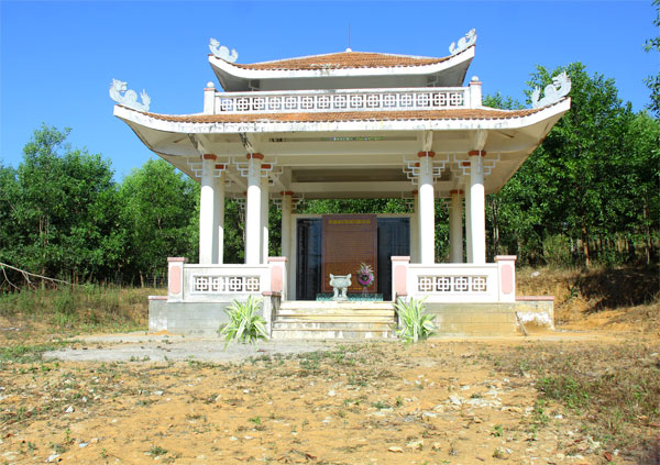
Bac Ai Ancestral Pagoda is located on Mac Dinh Chi street, Quyet Thang ward, Kon Tum city. The pagoda was built in the 8th year of Bao Dai (ie 1932 to 1933). Located on a high ground, the pagoda faces south, following Hue architectural style, Mon-shaped, including the Main Hall, Dong Lang, Tay Lang and Three Entrance Gate. Leader Vo Chuan, designed and urged both Kinh people and ethnic minorities to explore the jungle hill to build a pagoda, designed in the style of the word "Mon". In the year of the Goat, 1931, the Central provinces suffered consecutive droughts and crop failures, and people were hungry. Therefore, in the late years of 1931 and 1932, immigrants from the provinces of Hue, Da Nang, Quang Nam, Quang Ngai, and Binh Dinh flocked to the highlands and Kon Tum. During this migration, 70% died of starvation along the way, the remaining 30% reached the promised land. They cleared the forest for farming, but in this place they encountered many unforeseen things: wild animals, raging cobras biting countless people to death, people were confused and scared, night and night in this land, things happened. Many scary phenomena occurred. In 1932, Director Vo Chuan invited Mr. Hoang Thong, head of Bach Sa Pagoda, Quy Nhon, and the monks to go to Kon Tum to fast for 3 days to pray for the souls of unjustly deceased people. After the funeral ceremony, Mr. Vo Chuan asked Mr. Hoang Thong to prove his name Bac Ai. Charity is immense love, regardless of religion, Kinh people or Upper people. The pagoda was given the sign "The Four Bac Ai Tu" by King Bao Dai in 1933. In 1990, the pagoda was restored with the organization of the Venerable Abbot Thich Chanh Quang. Looking at the overall architecture, Bac Ai Patriarch Pagoda was built in the North-South direction, in Mon style, opening for that direction is the three-entrance gate, leading to the main hall in the center and the left and right sides are Dong Lang and Dong Lang. Tay Lang. The main hall consists of 3 rooms and 2 wings. The ancient building is divided into 3 compartments: front hall, middle hall, and upper hall. The roof is tiled, the brick walls are whitewashed, and the ceiling is covered with ceilings. The rafters, rafters, and columns all use precious woods such as purple star, rosewood, and redwood, elaborately and elaborately carved by Hue artisans. This space worships Tam The Buddha, Amitabha Tam Ton, Hoa Nghiem Tam Thanh... In particular, there is a stele recording the merits of French Captain Quenin and a wooden pillar symbolizing the 7 skulls of a Japanese officer who committed suicide at the pagoda yard at the end of World War II. Outside the main hall is Hoa Vien, where tombstones, towers, and shrines worship the God Emperor Bon Canh, Mountain God, Doan Quan and tru house are concentrated. Through many restorations, Bac Ai Ancestral Pagoda's original architectural features have been changed, and some unique sculptures such as flanking dragons and winding ropes are no longer there. The system of worship statues is covered with a layer of bright bronze, unable to retain its pristine beauty. However, a number of precious artifacts with visual artistic value such as the Statue of the Three Holy Mother Goddesses, the Guan Yin statue made of cracked ceramic, the Hoang Phi, the Couplet, the Ordination box, the Seal, etc. are still on display. subtle traces of time. Currently, Bac Ai Ancestral Pagoda is one of three communal houses (Vo Lam Communal House, Trung Luong Communal House, Bac Ai Ancestral Temple) that have been recognized by the People's Committee of Kon Tum Province as a historical-cultural relic. provincial level Source: Kon Tum Tourism
Kon Tum 1930 view
The Dak To - Tan Canh victory shook the entire US-Puppet defense system in the Central Highlands, expanding the liberated area and with the Quang Tri victory, the Southeast region created a new situation in the war. Southern school, contributing to defeating the strategy of "Vietnamization of the war", "Nich Son Doctrine" in Indochina, forcing the US to sign the Paris Agreement to withdraw troops from Vietnam. The Central Highlands is an important strategic area of the region. Among them, Kon Tum is the northern tip of the Central Highlands, located at the intersection of the Vietnam - Laos - Cambodia border; connecting the North - South corridor and the corridor between East and West Truong Son. With this important geopolitical position, the US empire and the Saigon puppet government have concentrated all forces to build the North Kon Tum region into the most solid defense area in the Northern Central Highlands, centered on Dak To - Tan Canh defense cluster. From 1957 to 1972, the US-Puppet built in Dak To - Tan Canh the most solid defense system including base E42 in Tan Canh and base Dak To 2. Therefore, Dak To - Tan Canh The scene became the site of many fierce battles between us and the enemy. In particular, many major campaigns were carried out here such as: Dak To 1 Campaign in 1967, the Central Highlands armed forces destroyed part of the 4th Infantry Division, the 1st Airborne Cavalry Division and The US 173rd Airborne Group at height 875 contributed to the General Offensive and Uprising of Mau Than in 1968, Dak To Campaign 2 in 1969, we destroyed many enemy forces, contributing to defeating the local war strategy. Ministry and the US "search and destroy" plan on the Central Highlands battlefield and especially the 1972 Spring-Summer campaign in the Northern Central Highlands, the focus of which was the liberation of Dak To - Tan Canh. Implementing the guiding policy of the Politburo and the Central Military Commission, our units decided to open the Spring - Summer 1972 campaign with the aim of "Destroying the enemy, liberating Dak To - Tan Canh, if conditions permit, liberate Dak To - Tan Canh". release Kon Tum town. The development direction may be in the direction of Plei Ku; if conditions permit, expand the liberated area west of Plei Ku, liberate Buon Ma Thuot town, forming a complete base connected to the base. Southeast region". Kon Tum Party Committee has mobilized maximum local army forces, guerrillas, and civil servants to coordinate with the main force of B3 and Zone 5 to participate in the campaign. On the enemy's side, the total number of enemy forces deployed in this area amounted to 28 infantry battalions, 6 artillery battalions, 4 armored battalions. The enemy was determined to concentrate their forces to form a solid defense line. prevent the liberation army from taking over the Central Highlands. With the concentration of forces and careful preparation, the two sides created a fierce, fierce battle with complete victory in favor of the liberation army. At exactly 11:00 a.m. on April 24, 1972, the liberation flag given by the Kon Tum Provincial Party Committee to the 66th Regiment on the day of the departure ceremony was carried into battle by our soldiers and fluttered atop the center of the enemy base. , announced the liberation. The Dak To - Tan Canh defense group, which the US and Puppet dubbed the "steel belt" in the Northern Central Highlands, was completely destroyed by our troops. The victory of Dak To - Tan Canh along with the victory of Quang Tri and the Southeast region were campaigns that had extremely important strategic significance. They created a new situation on the Southern battlefield, contributing defeated an important strategic step of "Vietnamization of the war" and "Nich Son Doctrine" in Indochina, forcing the US to sign the Paris Agreement and withdraw troops from Vietnam. With the determination "Truong Son transforms - Po Ko rises up, wipes out the enemy, liberates Dak To", "All for the front line, all to defeat the American invaders", the people of all ethnic groups in the region Kon Tum province has mobilized maximum human and material resources for this campaign. The "revolutionary noodle fields", "liberation noodle fields", "the sound of pestles pounding rice" all night long... providing food for the front lines or the image of a mother "Holding a gun in her hand, carrying her baby in front, carrying bullets on their backs" of the Kon Tum People of all ethnic groups will forever become a noble symbol of the will of all for lives, for national independence and the desire for peace. With profound historical significance, in 2017 "Dak To - Tan Canh Victory Site was recognized by the Prime Minister as a special national relic. Source: Propaganda Department of Kon Tum Provincial Party Committee
Kon Tum 1882 view
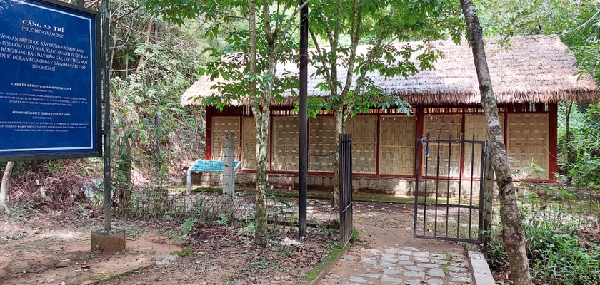
Dak Glei Prison belongs to Dak Choong commune, Dak Glei district, Kon Tum province. The Dak Glei Prison historical relic cluster includes three small works: The guard post area, Can An Tri area and the Prison area. The entire relic area is located on hills, surrounded by high mountains, streams, and valleys. Dak Glei Prison was built by the French colonialists in 1932, where Vietnamese revolutionary soldiers were detained in the years 1932 - 1954. At the same time, the colonialists also quarantined influential revolutionary activists. with a plot to control the entire Central Highlands. Initially, Dak Glei prison only detained people who did not submit to the ruling policies of the French colonialists and their henchmen. But since the end of 1939, the French colonialists have turned this place into a place to imprison communist soldiers after intensifying the repression of the revolutionary movement. Not only is it the place where famous revolutionary poets like To Huu were imprisoned, this is also where many key Party figures were arrested such as Nguyen Duy Trinh, Chu Huy Man, Huynh Ngoc Hue, Le Van Hien, Tran Van Tra , Le Ba Tu, Ha Phu Huong and Nguyen Tat Thang. Dak Glei Prison is a rectangular architectural work, consisting of one floor, an area of about 200m2, 19.85m wide, 10.2m deep, including 4 rooms. Located opposite Dak Glei prison through a yard about 20 meters wide is a one-story house with 2 small rooms, also built of stone, the outer room is the guard station, the other is the kitchen. From Dak Glei prison, going down the hillside about 150m is a "solitary prison" about 12m2 wide, built from February to June 1942 right after the escape of two patriotic revolutionaries, To Huu. and Huynh Ngoc Hue. In this prison, the space is both stuffy and gloomy, full of chains and shackles... Located between the prison and the station area is the An Tri prison with rows of prison cells built of bamboo and wood. Each prison has a stall for prisoners to lie down with their heads facing the middle, their feet shackled to the outside, each stall holds about 20 prisoners. In the evening, guards often count feet to check the number of prisoners. Because it was only built of bamboo and unstable wood, the An Tri stretch area currently has no traces of the construction due to differences between recorded documents, and it is impossible to estimate the exact number of 2 or 3. female. Dak Glei Prison is also known by Kon Tum people by another familiar name, To Huu Prison, because during the anti-French period, this was the place where the famous revolutionary and poet To Huu was imprisoned. This place is associated with the spectacular prison escape story of poet To Huu here. Specifically, in early 1942, To Huu and comrade Huynh Ngoc Hue planned to escape from prison. After that event, the French colonialists terrorized other communist soldiers and arrested our people's comrades in An Tri camp and imprisoned them. Today, the relic site has been being restored and renovated, the road system to the relic has also been invested and built smoothly, worthy of being a revolutionary red address, with great educational significance, a A proud symbol of the resilient fighting spirit of revolutionary soldiers. On December 30, 1991, the Ministry of Culture, Sports and Tourism recognized Dak Glei Prison as a National Historical Site. Source: Kon Tum province electronic information portal
Kon Tum 1868 view
"Kon Tum Prison" is located at Truong Quang Trong Street, Quyet Thang Ward, Kon Tum City. "Kon Tum Prison" reflects an early historical period of the movement to fight against invaders in our country. Kon Tum Prison was built by the French colonialists from 1905 to the end of 1917. Kon Tum Prison was built next to a large ditch next to the prison on the East-North side of Street 14 (now Phan Dinh Phung Street - Ho Chi Minh Highway running through Kon Tum city); West - South is the green loincloth soldier station; East - South is the embassy, the puppet leader's palace, and the Police Department. They placed Kon Tum Prison under siege and isolation. To facilitate control, they dug a deep trench 150m long, 100m wide, designed four rows of houses in a box shape (square) with an area of about 2.5 hectares, four corners of the prison had 4 bunkers built up, guarded day and night. secure room. The prison is built in the style of the old French fortress Vauban (Vo-ice) of the 17th century. The roof is tiled, the walls are made of whitewashed tocsi, the four sides are not covered by walls like other prisons, four cells are vertical and horizontal. built together into a square, each 18m side has a door and two high huts so the guards can observe inside and outside the prison; In the middle is a small, narrow square yard, the width of a row is 3.5m, of which 2m is laid with planks, 1.5m is a path, people lying on the plank floor can see outside the yard. Kon Tum Prison is a place to detain political prisoners escorted by the French colonialists from Nghe An, Ha Tinh, Thua Thien Hue, and is also a place to provide workers to explore the plateau and open Road 14. According to numbers According to records, this place held about 500 political prisoners and nearly half of them died. Specifically, during the 6-month process of building Road 14, the French colonialists exploited prisoners of war's labor to the point of exhaustion, leading to the death of 210 people in this place. During the years of resistance against the French, Kon Tum prison was considered the most brutal killing place. Kon Tum Prison was once the site of many protests by communist soldiers to protest against forcing prisoners to build roads in Dak Po. Although the protests here were all brutally massacred by the French colonialists, this sacrifice made them admit defeat and was forced to close in 1935. It can be said that Kon Tum prison is proof of this. denouncing the barbaric crimes that the French colonialists committed against our people in the period 1930 - 1931. At the same time, this is also a symbol of the resilience and indomitable struggle to protect the Fatherland of communist soldiers. in Kon Tum land. In 1975, when the war ended, Kon Tum prison became a historical relic of South Vietnam. After the ruins of the war, today only the graves and memorial stele of 8 revolutionary soldiers remain. In 1990, Kon Tum prison was recognized as a national historical and cultural relic site. Source: Kon Tum province electronic information portal
Kon Tum 1867 view
The revolutionary historical relic area of Kon Tum Provincial Party Committee Base is located in the Northeast of Mang Ri commune, Tu Mo Rong district, Kon Tum province. It is one of the bases with a very important position and strategic role in the resistance war against the US to save the country of Kon Tum Province in particular and the Central Highlands in general. The base was built, consolidated and developed in a very favorable area. located in the revolutionary heart of the Xo Dang ethnic population. This place has a very complicated divided terrain, with a continuous system of hills and mountains located in the Ngoc Linh mountain complex, with high mountains and extremely dangerous deep streams, making it very difficult for the enemy to detect. attack us. But on the contrary, this is a very convenient area for us in terms of communication system, located at the northern tip of the Central Highlands, the gateway connecting to the Socialist North, where our bases and basic areas are adjacent. from all directions in the province. On that basis, it creates favorable conditions for us in the process of moving as well as in the process of attacking or retreating to defend. Because of such favorable conditions, the Provincial Party Committee stood up to operate and direct the struggle during the period from 1960 to 1972. In early 1955, the Kon Tum Provincial Personnel Committee moved to Kon Po Oai and Kon Po E (Po E commune), then moved to Dak So Lo and then moved back to Nuoc Che (now in Ngoc Tem commune, Kon Plong district), stabilize the organization and direction, and urgently promote the shift in ideology and organization to suit the new situation. At the end of 1959, the Kon Tum Provincial Party Committee moved its agency to H80 (now Tu Mo Rong district) located in Mo Gia village, Mang Ri commune to promptly direct the struggle movement in the coming period. Because the terrain H29 (Kon Plong) is remote, the direction is difficult and timely. So the Kon Tum Provincial People's Committee chose the location at Dak Y Hai stream in Mang Ri commune as a base, because this is a strategic military as well as political area, behind the mountain range. Majestic Ngoc Linh Mountain with an altitude of 2598m is located to the north, to the east is the base of the Party Committee of Zone 5. This area creates a convenient traffic corridor for routes from east to west. In addition, this is also a strategic area for agricultural economic development of wet rice cultivation along two streams Dak My (H30) and Dak Posy (H80). There is also a fairly flat valley with good soil. Providing food sources for the Provincial Party Committee's long-term operations. Moreover, the people here are very good, over 70 villages are of the Xo Dang ethnic group, our revolutionary base where no puppets come. To stabilize long-term operations and direction, at the beginning, the Provincial Party Committee built working departments with rudimentary materials such as bamboo, wood... with large areas. The area of each room is 25m to 30m square. In addition, to ensure safety and prevent bombs and bullets when the enemy detects them, the Civil Affairs Committee also equips a system of trenches and shelters surrounding the working area of the Secretary and Deputy Secretary of the Office. Provincial Party Committee room, logistics, cipher department... And are arranged quite methodically in a closed, continuous system stretching from north to south along the hillside at an altitude of 1922.6m located in the heart of two streams. Dak Y Hai stream is large and Dak Y Hai stream is small. Here, the Provincial Party Committee successfully directed 4 Provincial Party Congresses (from the 1st Congress, March 9, 1960 to the 4th Congress, October 26, 1971), setting out important decisions, Directing the army and people of all ethnic groups in Kon Tum province to fight against the Americans and save the country, such as: Deciding on an order to start a march to gain control over the countryside; General offensive and uprising during the Tet Offensive (1968); Dak To - Tan Canh Campaign, moving towards liberating Kon Tum province... In addition, the Provincial Party Committee has mobilized the strength of ethnic groups and people from all walks of life, mobilized the masses, and well implemented core contents with people as the basis. On that basis, during the struggle against the US, people of ethnic groups in the base areas such as Ngoc Lay, Te Xang, Mang Ri... actively participated in all activities. Among them, especially the people of Mang Ri commune contributed 4,000 working days, participating in the fire line, carrying rice and ammunition. People's cadres and armed forces of the commune's militia and guerrillas directly participated in 17 large and small battles, destroying and disintegrating two American and puppet battalions, and destroying many enemy war vehicles. Transported and protected hundreds of officers from above to return safely, received and nurtured many key units of the Province and military zones during the gathering in the commune. Sharpened 5 million spikes and arranged hundreds of spike holes, made homemade weapons to fight the enemy, contributed to the revolution each year 600 baskets of rice, 5,000 wheat stalks, hundreds of buffaloes, cows, pigs, chickens and tons of other food… The Provincial Party Committee Base relic will forever be a red address, a symbol of the revolutionary loyalty of the army and people of Kon Tum province. With that historical significance, the Kon Tum Provincial Party Committee Base Relic (period 1960-1972) in Mang Ri commune, Tu Mo Rong district was ranked a provincial historical relic by the Kon Tum Provincial People's Committee on August 2, 2019. 2007. Source: Kon Tum province electronic information portal
Kon Tum 1860 view
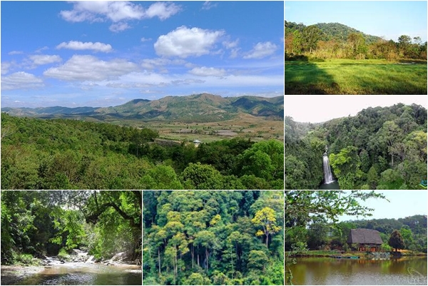
Chu Mom Ray National Park is located in Sa Thay and Ngoc Hoi districts (Kon Tum province). Right next to Chu Mom Ray National Park is Cambodia's Virachey National Park and Laos' Southeast Ghong Conservation Area. The flora of Chu Mom Ray National Forest is rich and diverse in species and status. There are about 1,534 plant species here, including 113 rare species belonging to the orchid family, gymnosperms, dioecious species, cycads, cycads, bamboo pine, rosewood, rosewood... The fauna of Chu Mom Ray National Park records 718 species, including 115 species of mammals, 275 species of birds, 41 species of reptiles and amphibians, 108 species of freshwater fish, and 179 species of insects. Among them, there are 124 rare species listed in the Red Book of Vietnam and the world, typically: red-cheeked gibbons, Truong Son muntjacs, gaurs, Indochinese tigers, elephants, black bears, fire leopards..., false lizards. 4 new stripes, white-edged snake, daisy-fronted snake..., hornbill, peacock, earth eagle... This place once marked many fierce battles during the period of "cutting Truong Son to save the country". Some places in the forest still have traces of trenches, bomb craters... The total area of Chu Mom Ray special-use forest is about 54,583.59 hectares; production forest 1,665.64 hectares; buffer zone 188,749 hectares. Including Bo Y and Sa Loong communes (Ngoc Hoi district); Ro Koi, Sa Nhon, Sa Son, Mo Rai, Ya Xier, Sa Thay town (Sa Thay district. This is where ethnic minority communities live, notably the Gia Rai and Ro Mam people. The proud point of the National Park is that there are 114 species in the Vietnam and world red books. In particular, the grassland (Ja Book valley) is the largest in Vietnam (more than 9,000 hectares) and has attracted many important species of ungulates and carnivores such as Truong Son muntjac, wild buffalo, tiger, etc. gaur, bison, elephant, black bear, fire leopard... and hundreds of species of reptiles and amphibians. In addition, on high mountain peaks such as Ngoc Linh, Ngoc Tu Ba, Chu Mom Ray peak... are home to many species of primates and arboreal animals such as gibbons, langurs, and precious birds such as hornbills. , land eagle, peacock… This is one of 94 special-use forests in Vietnam, with the largest area of primary forest and containing rare genetic resources. In 2004, Chu Mom Ray National Park was recognized as an ASEAN Heritage by the Association of Southeast Asian Nations. Source: Vietnam National Tourism Administration
Kon Tum 1800 view
The Indochina junction is not only famous during the resistance war against the US, but today this place is becoming very attractive to tourists on their journey to visit Kon Tum - the northernmost tip of the Central Highlands of Vietnam. The place of the Indochina junction on the majestic Truong Son range has always been in the memories of soldiers and young volunteers on their way to the Southern battlefield, battlefield C (Laos), battlefield K (Cambodia) over the years. Unforgettable war. This is the land known as the rooster crowing that all three countries hear together. Now this land is becoming one of the attractive tourist destinations for domestic and foreign tourists. Where places have gone down in history such as the Indochina junction (where Truong Son West road meets Truong Son East road during the resistance war), historical relics of the victory of Dak To - Tan Canh in April 1972; The border marker was jointly built by the three brother countries Vietnam - Laos - Cambodia on a mountain top 1,000m above sea level, about 30km from Playku town. This milestone was constructed by Kon Tum province in December 2007 under the supervision of experts from three countries sharing a common border. Representatives of the three countries' Ministries of Foreign Affairs held a solemn inauguration ceremony on January 18, 2008. The special milestone weighs 900 kg, is made of triangular cylindrical marble, is 2 meters high, and on each side of the milestone facing each country is attached the national emblem, the year the milestone was installed and the country's name in red letters of the government. that country. This is the second milestone marking all three countries to be placed on Vietnamese soil. The first milestone is the unified construction of the three countries Vietnam - Laos - China in A Pa Chai (Dien Bien). From the border junction marker, visitors have the opportunity to see the panoramic view of the Indochina junction land. Also here, tourists who want to visit Laos and Cambodia can complete exit procedures at the Vietnam border station at Bo Y international border gate. Source: Kon Tum Tourism
Kon Tum 1706 view
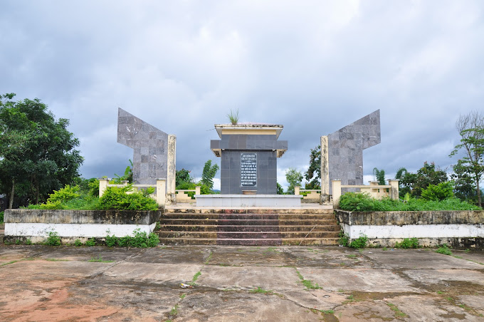
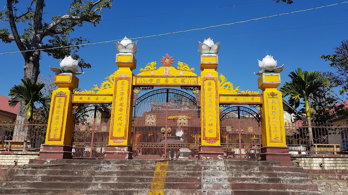
The evidence area of Kon Ho ring Church in Kon Ho ring village, Dien Binh commune, Dak To district, Kon Tum province is a place that marks the crimes of the American imperialists and the Saigon puppet government. Here, on the night of May 25, 1972, the US imperialists and the Saigon puppet government used planes to bomb and bomb the Kon Ho ring church and monastery, killing 500 innocent people and killing hundreds more. injured. More than 10 years ago, to commemorate the people who died due to the crimes of the American imperialists and the Saigon puppet government, Kon Tum province invested in building the Kon Ho ring Church relic area. The project is solidly built, with many main items such as: Memorial stele with content reflecting the crimes of the enemy, green campus, fence... After completion, the Kon Church Relics Area Ho ring has become a destination for local people as well as tourists inside and outside the province. Kon Ho ring Church is an outstanding religious architectural work in Dien Binh Commune, Dak To District, Kon Tum Province. Built in 1959, this church is the gathering place of the K'ho community, an ethnic minority living mainly in Kon Tum. Kon Ho ring Church stands out with its unique architecture, inspired by the traditional culture of the K'ho ethnic group. The temple roofs are made from bamboo and coconut leaves, creating a wild, rustic beauty that is no less impressive. Inside the church, paintings and statues of saints are carved on wood, creating a sacred and solemn atmosphere. Kon Ho ring Church is not only a gathering place for religious ceremonies but also a place to attract tourists and those who love culture and architecture. Visitors coming here will be able to visit, learn about the culture and history of the K'ho ethnic group and also have the opportunity to experience their life. In addition, Kon Ho ring Church is also a place where you can learn about the spiritual life of local people, as well as participate in religious activities such as festivals, seminars, and learn about ethics and lifestyle. nation's life. With its beauty and special historical and cultural value, Kon Ho ring Church has become a tourist destination not to be missed when you come to Kon Tum. Take time to explore and experience the feeling of peace and quiet at this location. Surely you will have memorable and meaningful experiences when you come to Kon Ho ring Church. Source: Kon Tum province information portal
Kon Tum 1696 view


 vn
vn en
en ja
ja ko
ko zh
zh VIP member benefits