Explore the history, culture, people and beautiful landscapes of Vietnam on the 63Stravel travel app
Download the 63stravel app


Quang Binh 490 view
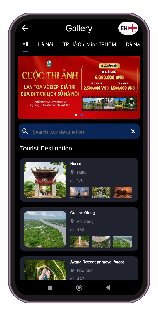
Download the 63Stravel app to immerse yourself in countless beautiful photos of Vietnam
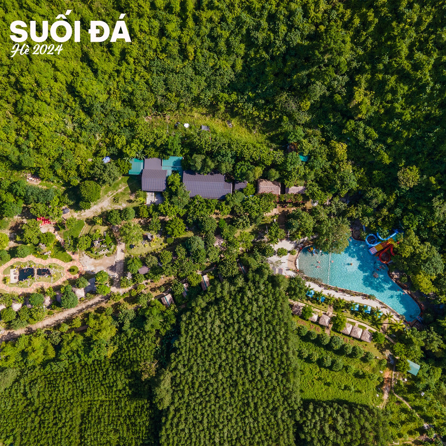
Suoi Da tourist area is truly a great place for tourists to stop, rest and have fun in the upcoming summer.
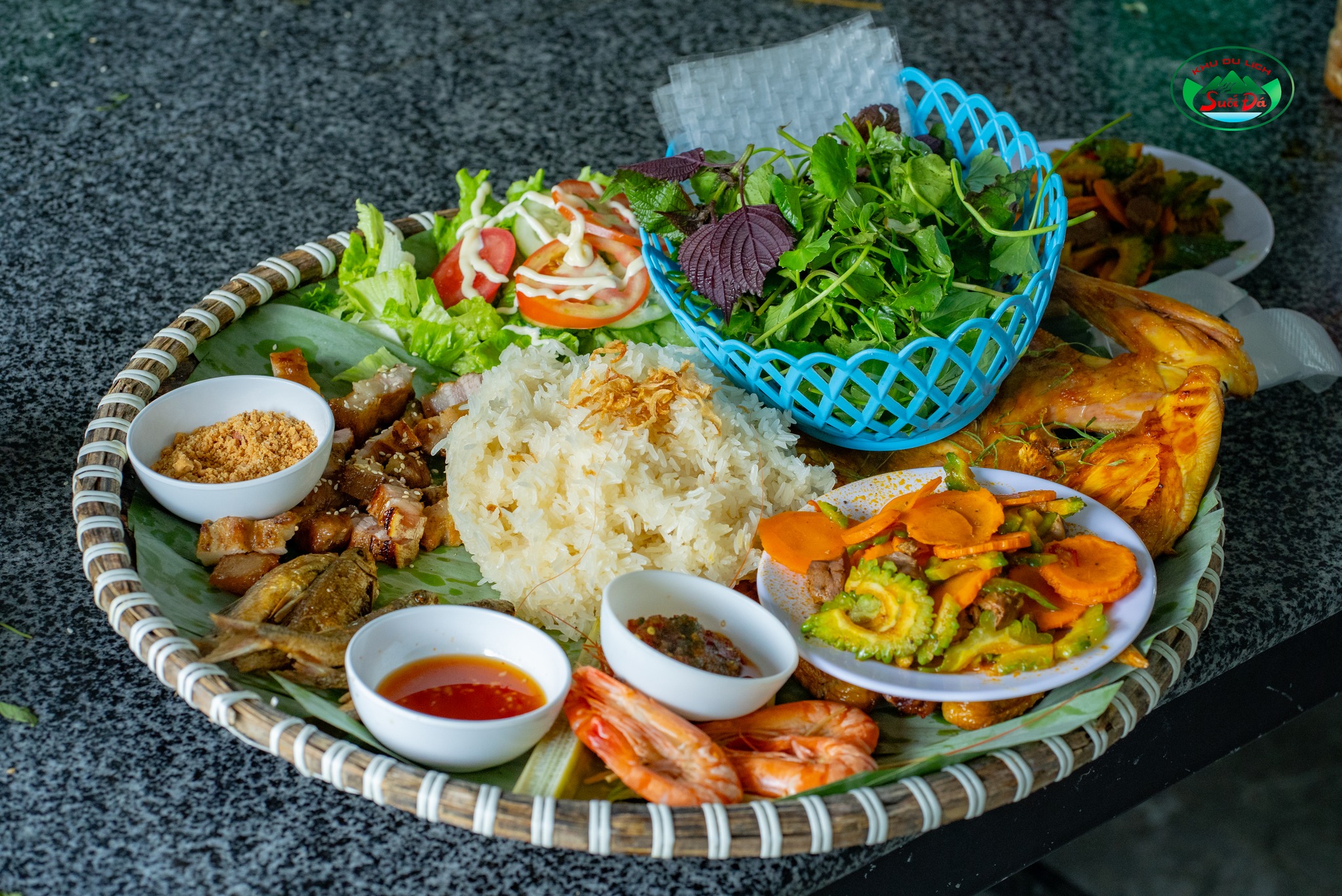
Coming to Suoi Da, visitors can also enjoy extremely rustic and exotic culinary flavors.
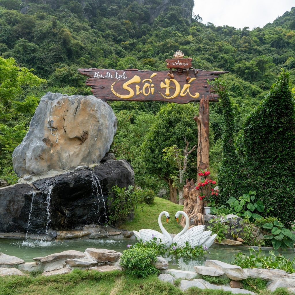
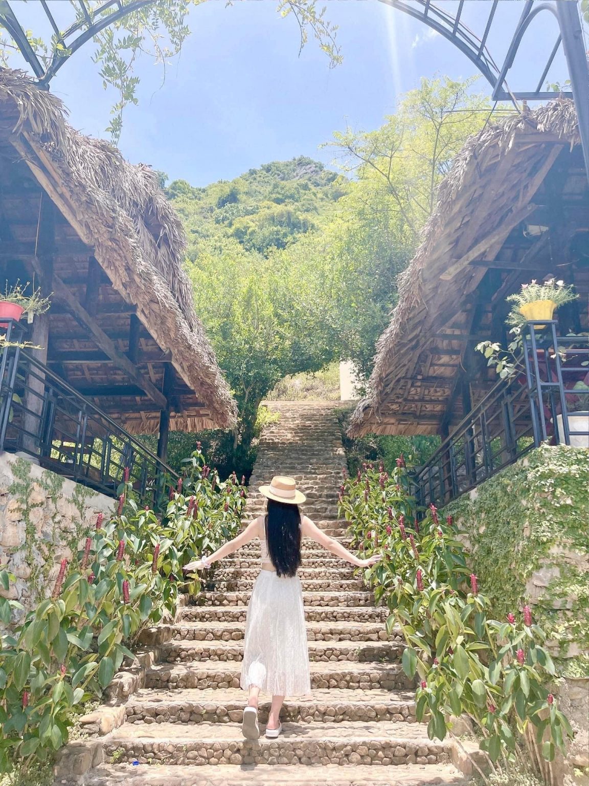
With a bright and harmonious picture of nature, visitors will take home quite a few beautiful photos.
With many majestic and poetic natural scenery, this place is an ideal place for virtual photos of tourists when coming to Quang Binh.
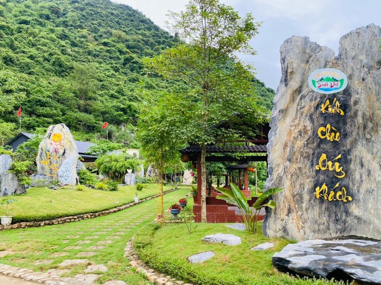
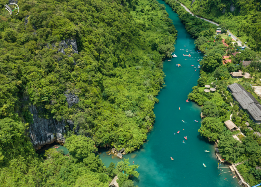
Suoi Da tourist area in Quang Binh is an ideal destination for those who want to immerse themselves in nature and participate in recreational activities.
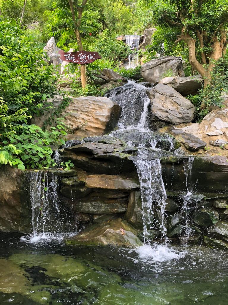
The name Suoi Da comes from a stream here, because this stream is very cool and originates from deep in the forest.
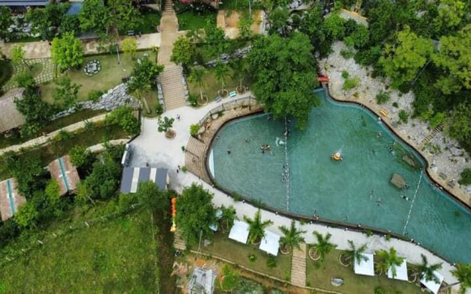
The tourist area has an area of 3 hectares, including many items such as swimming pools, entertainment areas, restaurants,...
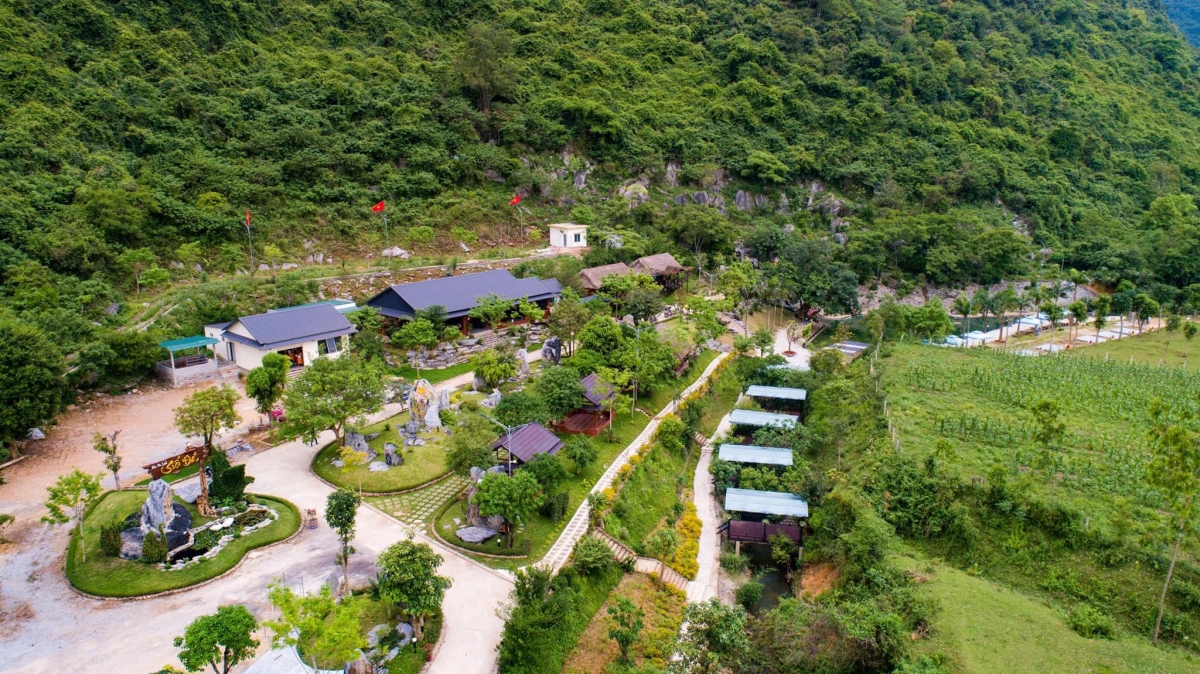
Suoi Da Quang Binh tourist area is a new destination coming into operation in 2022 located in Village 3, Phuc Trach commune, Bo Trach district, Quang Binh province.


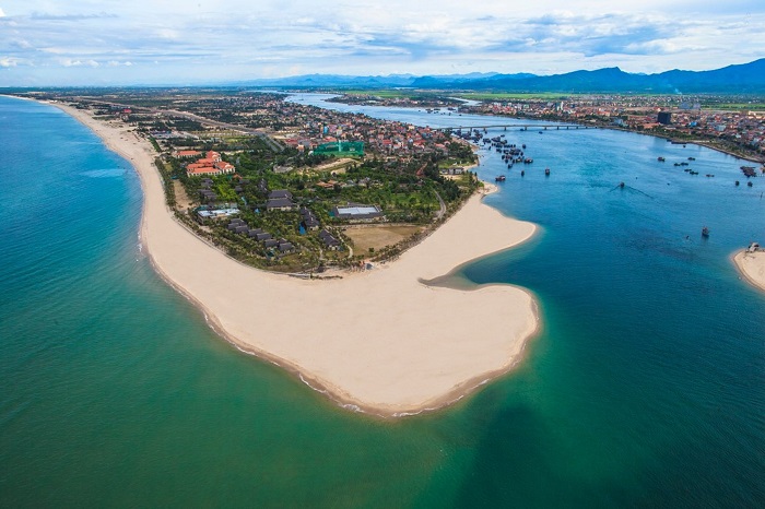
Coming to Bao Ninh, you will be immersed in an extremely open, wild and quiet natural space. You will only hear the whispering waves and the whirring wind in your ears without being crowded. like other key beaches. In addition, around are green coconut palms swaying in the wind and scenes of simple activities of people in Bao Ninh fishing village. You should come here in the early morning to catch the brilliant sunrise on the sea, when the first rays of the day begin to appear in the distance, the illuminated sea surface becomes beautifully iridescent. Or you can also walk barefoot on the beach in the late afternoon, when the sunset closes the day and the fishing boats return after a day at sea. Bao Ninh Beach is right next to Nhat Le beach, so if you want to visit Nhat Le, you just need to go through Nhat Le bridge to get there. In addition, standing on Nhat Le bridge and looking down at the water and sea surface of Bao Ninh is extremely beautiful and peaceful. After the morning watching the sunrise on the sea, you can also move to Bao Ninh square located right on the beach with extremely attractive and attractive entertainment activities. If you are lucky enough to come during the festival season, you can also witness the fishing and harvest festival that the fishing village people set up. Some attractions around Bao Ninh beach that you can visit are the ancient Citadel relics, Ca Ong temple or Mother Suot monument, Quang Binh Quan, General Vo Nguyen Giap's tomb or especially if there is one. Maybe Son Doong cave... Historical sites around this area will be an opportunity for you to gain more historical knowledge as well as social understanding, so you can learn more deeply about the war years. The arduous struggle of our army and people.
Quang Binh 1831 view
March to November
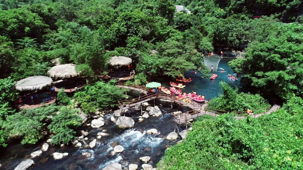
Mooc Stream is located in Phong Nha Ke Bang National Park, about 60 km from Dong Hoi city. To get here you can follow the Ho Chi Minh Trail, the stream flows into the Con River towards the delta. At Khe Gat intersection, turn west and go about 5 km to Mooc stream. The stream is covered with vast green forests, the climate is cool, and the air humidity is high. Summer travel here is very suitable, you will feel like you are lost in a giant natural air conditioner. Mooc Stream in Quang Binh originates from a large lake about 80 - 90 square meters wide, downstream the stream flows into a large river. There are many rugged rocky beaches here, creating an interesting landscape. Along the stream, the shade of trees spread out into the middle of the stream like umbrellas above the water. Trees that grow well help retain water and humidity, making the air cool and fresh. Mooc Spring appears in the wild natural landscape of deep forest, tourists seem to be overwhelmed by the beautiful scene before their eyes. Each stream, tree branch and green grass is full of life, the tingling sound of nature blends with the sound of flowing water to create a lively harmony. On this S-shaped strip of land, there are places where people and nature can harmonize so closely. You can immerse yourself in the space of the mountains and forests to enjoy the feeling of relaxation, stretching all your senses to hear, to see, to feel the fragrance of life. Coming here, you can also participate in many entertainment activities, there are many thrilling games, requiring the player's flexibility and dexterity: Kayaking, hanging bridge, zipline... Sitting on a kayak, skillfully controlling the oar along the water flow to the fast-flowing sections, the player must brace themselves to keep the oar going through the strong current. The ticket price for kayaking at Nuoc Mooc spring is about 50,000 VND per session. Going on the suspension bridge is for those who are not afraid of heights. Take each step carefully on each wooden slat of the suspension bridge if you don't want to fall into the water. Not only are you careful, you also have to be very skillful to participate in this entertainment. Many rustic dishes are served here made from native ingredients: Stir-fried wild vegetables with garlic, grilled eel, grilled chicken, porridge soup. Sitting on thatched huts enjoying dishes brings a very new feeling. In the summer, Mooc stream truly becomes a wonderful ecological area, with cool spring water and fresh scenery. Going here with friends for a picnic on weekends or holidays will be a great idea, the wild nature will give you memorable photos. The tourist destination is quite new so everything seems "intact", seemingly separate from outside life. In addition, you can visit places near Mooc stream such as Chay river and Dark row. Dark Cave has deep underground streams flowing through creating air conditioning. Inside there are many multi-shaped stalactites and stalactites with almost no light, complete darkness. If you turn off the flashlight, it feels like everything is swallowed by darkness, the eyes are filled with suffocating blackness.
Quang Binh 1702 view
March to August

Famous as one of the world's largest natural wonders in Vietnam today, located in Quang Binh province and chosen by many tourists. This place not only contributes greatly to preserving nature, flora and fauna, but also creates an impressive tourist destination for tourists right from the first visit. Phong Nha Ke Bang National Park is located about 45 km from Dong Hoi city center. With a structure consisting of two main parts: Phong Nha cave and the majestic Ke Bang limestone mountain range many years old. Brings the feeling of being lost in a separate sky, both wild and imbued with the natural beauty of an attractive ecosystem. Located in Quang Binh province, a city in the Northern region, it has a tropical monsoon climate with two distinct dry and rainy seasons. To have a convenient trip to Phong Nha Ke Bang National Park, you should choose the time from April to August. At this time the weather is dry, little rain and beautiful sunshine, suitable for sightseeing and activities. interesting. As for the period from September to December, the weather is prone to rain and even storms. If you visit at this time, it will be quite disadvantageous to travel and cause many potential dangers. Besides, from January to March the high water season also causes disadvantages when visiting Phong Nha cave and other cave systems. Currently, choosing a hotel when visiting Phong Nha Ke Bang National Park is quite popular among tourists. Because this also affects the tourism process more or less. If you have questions about choosing a Quang Binh hotel, you can rest assured because this is currently a developed tourism province. When coming here, it is not too difficult to choose a hotel that suits the needs, interests and financial capabilities of visitors. To be more proactive about your time, you can choose to consult and book hotel rooms in advance at websites, or through the convenient Traveloka app. Referring to one of the attractions not to be missed when coming to Quang Binh national park, Phong Nha cave is known as "Thien Nam's first cave" with its majestic and wild beauty. After following the clear blue water, you will reach the cave entrance with a height of 10m, then proceed to explore the 8,000m long cave system, with 12 different large and small caves. Bringing unexpected experiences to visitors while visiting the national park. Through many changes, golden sand beaches, blue underground lakes and impressive stalactites have formed inside the cave. It all seems to create a vivid picture created by nature over hundreds of millions of years. To get in, you need to buy a ticket for about 120,000 VND/adult, free for children and rent a boat for about 550,000 VND/12-seat boat. Possessing an area of more than 40 hectares, the botanical garden is a diverse ecosystem and is also a conservation area not to be missed when visiting Phong Nha Ke Bang national park. Here, you can experience the process of Trekking to explore and check in to Thac Gia, Vang Anh Lake, and animal raising area. In addition, you can also visit the model exhibition house to see rare animals and plants. The ticket price to enter the botanical garden will be about 40,000 VND/adult and 20,000 VND/child. This promises to be an interesting and memorable experience for nature lovers who always want to discover the beauty and wonder of flora and fauna. Thien Duong Cave is known as the longest dry cave in Asia, with a total length of 31.4km, naturally formed in a limestone complex and surrounded by pristine, rich primeval forest. To reach the cave, you need to pass 524 wooden steps, then comfortably enjoy the cool atmosphere and the magical beauty of the impressive stalactites. Therefore, this place has become an indispensable tourist destination when coming to Phong Nha Ke Bang national park.
Quang Binh 1907 view
From April to August
When coming to Quang Binh, you must definitely visit Bai Da Nhay - located at the foot of Ly Hoa pass in Thanh Trach area, Bo Trach district, Quang Binh province. With a long coastline, fine golden sand and blue sea water, it creates a beautiful "background" with no dead corners, suitable for virtual living. The best time to go to Quang Binh is from the first months of the year until May (according to the solar calendar). June, July, and August are quite sunny and hot, while September, October, November, and December are rainy and cold seasons. You can rent a motorbike in Dong Hoi to go to Da Nhay beach, which is also quite ok. From Dong Hoi City, you run towards Dong Hoi Airport and then go straight about 25 kilometers to get there. When you arrive, park your car at a convenient restaurant to eat lunch. The first impression that appears when coming to Da Nhay Beach is that the beach is clean with little trash, the sea water is clear and blue, and the air is cool. You walk a bit to reach the rocky beach. Attached is a set of stairs to climb to the top. Stand from above and look down to see the panoramic view of Da Nhay Beach. Rest assured that in Da Nhay Beach, there are many shops and restaurants close to the beach, with very reasonable prices, so you can eat and drink to your heart's content, always with fresh seafood. After finishing eating, you can rest in the hammocks under the hut and enjoy the cool sea breeze, which is also not a bad idea.
Quang Binh 1610 view
From January to December

Located in Tho Son village, Quang Trach district, Quang Binh province and about 3km from National Highway 1A, Vung Chua - Yen Island is known as the resting place of the heroic general of the nation Vo Nguyen Giap. This area has an area of about 10 hectares and is located right at the foot of the majestic Ngang Pass. Vung Chua is a clear blue beach with long stretches of white sand and surrounded by a peaceful scene of endless green forests. Vung Chua faces the East Sea but is quite sheltered from the wind, so this place is said to be a land with a quite prime location. Yen Island is a small island about 1km from Vung Chua shore. If you go by boat, it will only take about 20 minutes to get here. Many people commented that Yen Island is like a screen emerging in the middle of the sea with the belief that this place will guard the land and sea, protecting human life. Vung Chua - Yen Island has now become a pilgrimage destination attracting many tourists to visit and burn incense to commemorate the heroic general every year. Local people have recounted that in the past this land was called Hon Nom based on the direction calculation. However, later a company brought the bird's nest here to raise it to exploit the bird's nest, so from here a lot of bird's nest came to live. The name Yen Island, Quang Binh, also came from there. So where does the name Vung Chua come from? According to local people, in the past there was a large pagoda in this area, but now through ups and downs of time, only traces of the pagoda's foundation remain, but the name Vung Chua comes from that. This area is also surrounded by three islands: Hon La, Hon Gio and Hon Nom, forming a three-legged triangle so it is quite airtight so ships often anchor when there is a storm. In addition to the tomb of General Vo Nguyen Giap, many people may still not know that on the island there is also an ancient tomb that has been passed down orally from people as the tomb of famous general Tran Dat, who had meritorious service in the Lam Son uprising against enemy from the North with Le Loi. After learning more about the history books left behind, we learned that the family of famous general Tran Dat was very famous in the area because there were many people who were awarded the title of marquis, duke or academician... However, the church they are currently in Thuan Bai village, Quang Thuan commune, Quang Trach district. So Quang Binh is honored to welcome two generals about 500 years apart to rest here. The grave of General Vo Nguyen Giap is located on the shore, at a 110m high point on Dragon Mountain, overlooking the sacred Yen Island, and the grave of famous General Tran Dat, who was instrumental in defeating the Northern invaders and saving the people, is also nearby. That area makes Vung Chua - Dao Yen more majestic.
Quang Binh 1731 view
From January to December
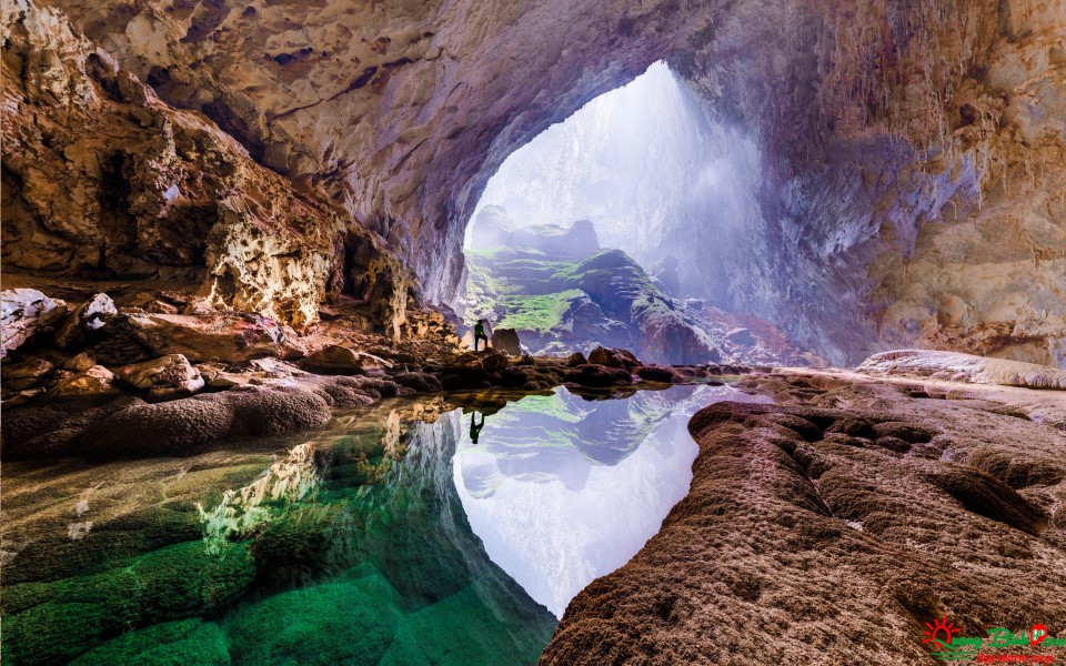
Located in the center of the Phong Nha - Ke Bang National Park relic complex, with a length of more than 5km, a width of more than 200m, a height of up to 150m and it is estimated that it can be completely "tucked into" a skyscraper with about 40 floors, Son Doong Cave (also known as Son Dong) is the largest natural cave in the world and is a pride of Vietnamese people in general and Quang Binh people in particular when being discovered. Nature has bestowed upon it a priceless masterpiece of humanity. Because of this majesty and magnitude, people often refer to Son Doong as the "Great Wall" of Vietnam. To get to Son Doong cave, it will take you about half a day to go through a forest and wade through a small river. Reaching the cave entrance, every cold wind blowing in the cave will melt away all the fatigue of the arduous journey of "crossing the forest and wading streams". Not only will you be amazed by the vast space of the cave, you will feel extremely excited by the magical mystery hidden behind the magical thick fog in the cold winds. Not only famous for its giant size, Son Doong cave also has a rich flora and fauna ecosystem. Son Doong is home to many animals and is also a diverse vegetation with hundreds of different plant species, created by a fast-flowing underground river and partly exposed to sunlight. The cave collapsed. People have even developed a pristine vegetation cover without human footprints on a vast primeval tropical forest like a real 'Eden' on earth. Son Doong Cave attracts tourists because of its geological diversity in the special terrain of underground rivers and large caves. Exploring Son Doong cave, you will admire the system of limestone, stalactites, giant "pearls" and stalagmite columns up to 70m high created millions of years ago. With the purpose of preserving and preserving the beauty of the cave as well as ensuring the safety of visitors, Son Doong cave has not yet opened to the general public, but only about 500 people are allowed to participate in the tour. expedition every year. If you want to set out and become one of the few people to explore this magnificent cave, you will have to book a tour to explore Son Doong cave in advance at a quite expensive cost and also prepare good physical strength to ensure your health. Long trip to explore Son Doong.
Quang Binh 2196 view
March to August
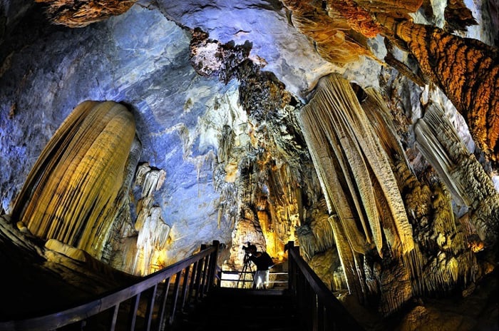
Located at an altitude of 360m above sea level, Thien Duong Cave has a temperature difference of 9 - 10 degrees Celsius from the outside. The small cave entrance is hidden behind cliffs and forest canopy. The cave is divided into many large chambers, the widest place is over 200m wide and over 100m high. To ensure the condition of the cave floor, Truong Thinh Group built a wooden bridge 3.5m wide and more than 1000m long to serve tourists. This road currently holds a national record as the "Longest Wooden Road". Although it has a long history, Thien Duong cave was only discovered in 2005, by cave experts from the Royal British Cave Association. Also according to the association's announcement, Thien Duong cave has a length of up to 31.4 km. This place is considered one of the most beautiful caves in Quang Binh, and is also known as the "Underground Royal Palace" because of its majestic beauty and massive, sophisticated cave creation. At the same time, Thien Duong Cave is also recognized as the longest cave in Asia. As expected, it is the most magnificent and magical wonder in the world. The tectonic stalactite system in the cave is extremely diverse and rich in geological value as well as shape. In particular, the stalactites in the cave have images similar to cultural symbols of regions: Fairy Gods, Lady Buddhas, Stilt houses and terraced fields like the Northwest hills and mountains. The stalactite system of Thien Duong Cave is rich and colorful. The stalactite system in the cave continues to be built every day thanks to the drops of water diligently dripping from the ceiling of the cave. These are the unique features that make Thien Duong Cave worthy of being ranked first in the international cave rankings because of its aesthetics, science, splendor, spaciousness and many layers of enchanting stalactites. tourists' hearts. The time to visit the first 1000m on the wooden road system takes from 2 hours to 2 hours 30 minutes. Referring to Thien Duong cave in Quang Binh, you definitely have to know the special features of this place compared to other caves in the same population. The reason why Thien Duong cave is highly appreciated by international organizations is thanks to the following characteristics: It is the longest dry cave in Asia, throughout the length of the cave is an artificial wooden bridge system that keeps you safe throughout. Experience trip without spending too much energy to climb and explore. The 1000m long wooden bridge system is considered the longest wooden bridge in a cave in Asia today. Thien Duong Cave possesses strips of stalactites and stalagmites with shimmering, magical beauty that are considered the most beautiful in Asia. Thien Duong Cave with its mysterious beauty and challenging exploration journey will definitely bring you an extremely new sightseeing experience. As a giant cave, this place certainly contains many interesting and attractive things that are always ready to surprise and delight you.
Quang Binh 1423 view
From April to August
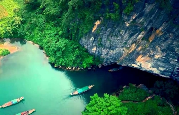
Located in Son Trach commune, Bo Trach district, Quang Binh province, about 45km northwest of Dong Hoi city, Phong Nha Cave is located in Phong Nha Ke Bang National Park. From Dong Hoi to Phong Nha, visitors will travel on the legendary Truong Son road. After arriving at Phong Nha tourist center, tourists follow the Son River to visit Phong Nha. Considered the "First Cave of Thien Nam" in Vietnam, protected by tropical forests. This is the first point to be put into operation for tourism to serve tourists in Phong Nha Ke Bang. According to scientists, the weathering process that creates caves in Phong Nha is a natural process that has taken place 250 years ago. million years. The main terrain types of Phong Nha - Ke Bang are limestone mountains and dirt mountains. Average altitude of 600 meters, narrow walls, vertical walls. Phong Nha Cave is located in the southeast part of the Ke Bang limestone massif. In a strongly weathered limestone area, an area of about 10,000 km2, extending 200 km north of the Truong Son range, all the way to Laos. In this limestone massif, there is a phenomenon of underground water flowing. With a length of 7,729m, a depth of 83m, a height of 50m with many large and small sub-cave branches. Including Bi Ki cave, Tien cave and Cung Dinh cave. This is a type of underground water cave inside the mountain with many characteristic stalactites. Legend has it that the hanging stalagmites at the cave entrance contributed to the poetic name "Phong Nha", meaning "Wind passing through teeth". The name Phong Nha also originates from here. Phong Nha stalactites are considered beautiful and took millions of years to form. Phong Nha is famous for its unique rocks named after natural shapes. The feeling of entering a fairyland, like "Lion", "Unicorn", "Vo Chau", "Royal Palace" or "Buddha Statue". After about 19km, it flows underground under the Truong Son range. The river appearing at the entrance of the cave has a blue water color in the dry season. And especially the red color of alluvium in the rainy season. Visitors can also explore the formation of stalagmites and stalactites in some of the 14 rooms inside the cave. About 1km inside is Bi Ki cave, a side branch located deep in the cave about 600m from the cave entrance. It is believed that at some point from the 9th century to the 11th century, the Cham people chose this place as a place of worship. After dozens of scientific explorations by the Vietnamese, French, British... Phong Nha is still there with its mysteries. Currently, many caves in Phong Nha Ke Bang are put into tourism exploitation. However, Phong Nha Ke Bang Cave is still the number one choice of tourists. Phong Nha tour is both gentle and suitable for many ages and poetic when going down the Son River to explore this cave.
Quang Binh 1502 view
From January to August
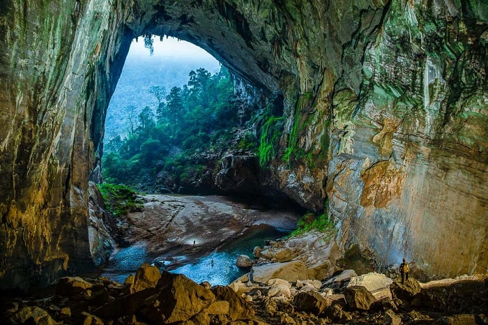
En Cave in Quang Binh has a total length of 1645m; through a mountain. The ceiling of the cave is 100m high in some places and 170m in its widest place. This cave is the 3rd largest in the world and is located after Son Doong cave and Deer cave in Malaysia. The cave was discovered by British explorer Howard Limbert and his wife in 1994. This name comes from the image of swallows living in this area. In 2015, images of Hang En and Son Doong cave were broadcast live by America's Good Morning television. Also that year, Hang En along with the world heritage complex of Trang An and Ha Long Bay were chosen as the setting in a famous movie called Peter Pan. Not only famous for being a large cave but also The wild beauty of this place has attracted the attention of many domestic and foreign tourists. When coming to Hang En, you will have for yourself fascinating experiences that are 1-0-2: On the journey to explore Hang En, visitors will have the opportunity to experience the life of the Bru - Van Kieu ethnic people in Doong village. The lives of people here are almost separate from the outside world due to the rugged terrain. However, after the Hang En tour took place, people's lives have improved significantly. With only a short 15-minute break at Doong village, visitors will have the opportunity to chat with people to better understand life here. You will hear stories about the villages, mountains and forests as well as their simple lives. Camping in Hang En: After a long walk and crossing rivers and slopes, visitors will come to the camping site to rest. During this journey, visitors will gather with the group to enjoy rustic dishes from Oxalis chefs with simple local ingredients. Admire the beauty of unique stalactites: You will wake up to welcome the new day by the sound of flocks of swallows chirping. The journey to explore Hang En will immediately be followed by stalactites with a life of up to millions of years. These stalactites are formed in the cave by drops of water flowing down from the cave dome. Visitors will travel a distance of about 1.6km to reach the back door of Hang En. This place is a majestic primeval forest with all kinds of mysterious flowers. It makes you lost in a vast paradise between nature, heaven and earth. Witness with your own eyes millions of swallows residing in caves: Wouldn't it be interesting to witness firsthand the activities of millions of swallows residing in caves? Don't forget to take some beautiful photos. This is definitely a 1-0-2 check-in point in Quang Binh. The journey to explore Hang En is truly one of the most wonderful adventures that not everyone has the opportunity to experience. So, if you have the opportunity, please enjoy it to the fullest and take lots of memorable photos.
Quang Binh 1277 view
From mid-December to September
Chay River, Toi Bo Trach Cave, Quang Binh is located on the territory of Son Trach commune, Bo Trach district, Quang Binh province. This is also a tourist destination located in the famous Phong Nha Ke Bang national park, about 50km from Dong Hoi city center. The reason the river is called Chay River is because the water source here originates from a waterfall called Chay. Not only that, people also passed down the sound of flowing water in this waterfall similar to the sound of a pestle pounding rice. Chay River has beautiful emerald green water, surrounded by nature, mountains and forests, creating a picturesque scene. Dark Cave is a part of the Phong Nha Ke Bang cave tourist area system. With a depth of 20m and a height of 40m, Dark Cave has become a tourist destination for many expeditions. The reason the cave is called "Dark" is because many people said that the "dark light" inside the cave entrance is thick, making it feel like you can touch it with your hands. Experiencing Chay River and Dark Cave is one of the most attractive tourist activities in the locality. Therefore, when choosing a tourist destination in Quang Binh, Chay River and Dark Cave are always on the tourist's exploration schedule. Chay River, Dark Cave, Mooc Stream are definitely the most ideal travel itinerary for you to fully explore the beauty of Quang Binh land. At Chay River, visitors should experience boating activities to both exercise and admire the charming natural panorama. The beautiful scenery on both sides of the river is created from limestone banks. When the water flows down, the limestone forms into extremely strange shapes. In addition, the rows of figs on both sides of the river also create a beautiful natural green color. Rowing on the Chay River, you will not only be satisfied with the beautiful scenery of mountains, forests and rivers, but also witness many underwater creatures on both sides of the river. The zipline game especially attracts young people, specifically this activity involves you dropping yourself from above, looking at yourself under the clear blue water of the Chay River. When ziplining Chay River and Dark Cave, you will be equipped with protective uniforms to ensure safety and have the best experience. To have extremely new moments at this destination, visitors can choose to ride the longest zipline in Vietnam inside Dark Cave. When you relax your body and immerse yourself in the beautiful natural scenery, you will feel extremely refreshed and relaxed. What attracts explorers and tourists to Dark Cave is that the inside of the cave is still very pristine, seemingly without any tourism exploitation. Therefore, stalactites also have many diverse shapes. The cave area is also a hiding place for many animals such as swallows, bats, and Ha Tinh langurs. In addition, Dark Cave is also a cave area located right next to the river, so the humidity inside is quite high, creating layers of moss clinging to the stalactites. Stepping inside the cave, you will feel the magnificence of nature. This is also a place for you to freely explore biological systems as well as fossils from ancient times. There will be many interesting experiences inside Dark Cave. If you read the Chay River Dark Cave review in advance when planning your itinerary, you will notice that a place you cannot miss is the mud bath area inside the cave. Natural mud bath is an interesting activity that helps you and your family and friends become more connected. Besides mud bathing activities, you can also swim through Thuy Tien lake or Bong Lai lake, and explore other caves of Phong Nha Cave. These places are all very attractive and worth a try. Chay River and Dark Cave are considered a natural masterpiece in Quang Binh. For tourists who love to explore new lands and admire natural beauty, this is truly a destination that should not be missed. Experiential activities at this resort also promise to bring you extremely comfortable and relaxing moments with friends and relatives.
Quang Binh 1316 view
From April to August
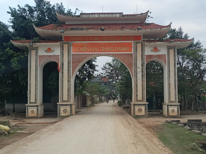
Trung Thuan war zone is located in the semi-mountainous area of Quang Luu and Quang Thach communes, Quang Trach district, about 5 km west of Ba Don town. Once an important revolutionary base for the army and people of Quang Trach during the resistance war against the French colonialists and American imperialists, Trung Thuan war zone has become a heroic historical testimony and the pride of every person. people around here. Trung Thuan War Zone is a national historical relic site in 1995. The war zone is located on the area of two communes, Quang Luu and Quang Thach. However, the main area still belongs to Quang Thach commune. The ancient Trung Thuan war zone was a valley surrounded by many high mountains and dense forests in a U shape. In the war zone, there was Chop Chai peak, nearly 1,000m above sea level, which became an ideal "observatory" for the soldiers. the whole region. In small hamlets of Trung Thuan such as Duong Khe, Ha hamlet, Xuan Vuong, Kim Thanh, Tam Da, Trung Chinh, Tien Mieu, Dinh Cu, Phu Luu, Van Tap... Archaeologists have discovered many Archaeological artifacts such as: Phu Luu bronze drums, Dong Son type I bronze drums, bronze fish hooks, bronze axes and traces of Lam Hamlet ruins. Trung Thuan during the Trinh - Nguyen conflict period was a large base of the Trinh army north of the Gianh River. Dai Don base (Trung Thuan) along with Roon station and Thuan Bai station were important strategic defense lines of the Trinh army. In the north of Gianh River, the remaining vestiges are Tau Voi well, Vong Bai island... During the Can Vuong period, Trung Thuan was the base of Le Truc's insurgent army in the Can Vuong movement against the French in Quang Binh. Trung Thuan is an important base in the entire Can Vuong base system such as Huong Son, Huong Khe (Ha Tinh), Quy Dat, Khe Ve..., the remaining vestiges are Bai Tap, Bach Thach, Linh Than, Fish pond, Grinding stone slot, Tien Mieu hamlet, Xuan Vuong hamlet. During the resistance war against the French colonialists, the Trung Thuan war zone was not only the place where the District Party Committee, the Administrative Committee and the headquarters of Quang Trach district worked, but also the place where they trained and prepared the uprising forces to seize power. power and additional forces to jointly defend Vo Xa to seize power in Dong Hoi town in August 1954. During the resistance war against America to save the country, Trung Thuan was the rear base of the B70 Corps of the Vietnamese People's Army. This is a transit point in the Ho Chi Minh road system to support human and material resources for the struggle to liberate the South and unify the country. Due to its important role, in 1968 and 1972, the Trung Thuan war zone was heavily bombarded by American aircraft. Local soldiers and people sacrificed a lot, however, with their stubborn will, that still did not shake the revolutionary spirit of the army and people here. With his important contribution, in 1971, Trung Thuan war zone was honored to welcome General Vo Nguyen Giap to visit and summarize the victory of Route 9-Southern Laos. Source: Quang Binh Newspaper
Quang Binh 2157 view
The church and grave of Admiral Le Truc are nestled next to the Gianh river, in Thanh Thuy village, Tien Hoa commune (Tuyen Hoa, Quang Binh). Admiral Le Truc was the famous leader of the Can Vuong insurgent army, an example of patriotic loyalty that descendants still talk about today. At the end of the 19th century, Vietnam's feudal society became more and more chaotic, with internal conflicts in Cochinchina and internal jealousy, and French colonialism trying to encroach on Cochinchina. Faced with the power of colonialism with capitalist production methods, the Nguyen feudal court continuously had to sign surrender treaties with France. After the Nguyen feudal court signed treaties to sell the country, all over our country from Tonkin, Central and Cochinchina, the resistance movement against the French emerged strongly, especially when King Ham Nghi issued a decree. In Can Vuong, the uprising spread throughout the provinces, causing confusion and fear among the French colonialists. In Quang Binh, the people's resistance movement emerged loudly, but the most typical was still the insurgent army led by Admiral Le Truc. Le Truc is from Thanh Thuy village, Quang Trach district (now Tien Hoa commune - Tuyen Hoa). He passed the Tao si (Three Giam Doctor of Martial Arts) degree, and was formerly a Hanoi military leader. When enemy general Henry Ryviere defeated Hanoi, Governor Hoang Dieu committed suicide and was dismissed by the court. By the time he received the Can Vuong edict in 1885, uprisings broke out everywhere. Le Truc gathered a number of soldiers and civilians to stand up in the Gianh River region, using Cua Xai in the Thanh Thuy mountain region as a base. Ton That Thuyet gave him the original uniform. From then on, he called on scholars and scholars in the area to follow Ham Nghi against the French. Le Truc's insurgent army grew stronger day by day, its scope of operations became larger, and its reputation spread throughout all areas. Le Truc organized many large and small attacks, raided enemy posts, and captured and killed traitor henchmen. Although the Can Vuong movement failed, patriotic writers and scholars were arrested and killed, but the patriotic spirit, indomitable will and traditional fire always burn brightly in the hearts of the people. the whole country in general and Quang Binh in particular. Around September 28 and 29, 1888, when he heard that King Ham Nghi was arrested and taken to Thuan Bai Fort, Quang Trach, he and a number of other admirals went to pay their respects to the king and surrendered. However, he still refused to accept the new reign name of King Dong Khanh, but only took the reign name of King Ham Nghi. In early 1891, Mr. Le Truc had to reconcile with France to protect the lives of innocent people. The Can Vuong Quang Binh movement ended. Le Truc died in his hometown in June of the year Dinh Meo (1918), in Thanh Thuy village, Tuyen Hoa, Tuyen Hoa, Quang Binh - at the age of 90. Le Truc died in his hometown, but his name is still associated with places such as village names, street names, and street names. His image, merit and unyielding will still live forever in the hearts of the people. In memory of a son who was loyal to the country, filial to the people, devoted and arduous for the sake of his country and country, the people and relatives contributed their contributions and resources to build the church and his tomb in the year 1912. The Tomb Relics and Commodore Le Truc Church were ranked as National Historical and Cultural Monuments on June 21, 1993. Source: Quang Binh Tourism
Quang Binh 1871 view
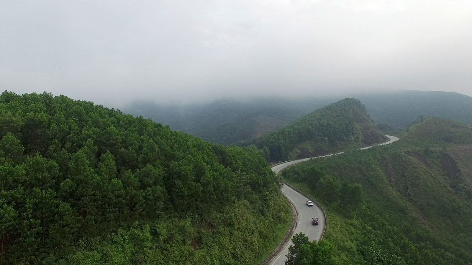
Da Deo Pass is located on the legendary Eastern Ho Chi Minh Trail associated with Vietnamese history. The 17km long pass is located in Thuong Hoa commune, Minh Hoa district, Quang Binh province. The reason people call it Da Deo Pass is because the pass lies across the top of a limestone mountain more than 10 km long. In the past, it was just a small trail, but during the Vietnam War, heroic youth volunteers opened Truong Son Road, a vital road for transporting troops, food, weapons... to support the war. Southern school. The people who went ahead carved stones to pave the way for our troops to follow, and that's why it was called Da Deo Pass. The terrain in Da Deo Pass area is quite diverse with alternating hills and valleys and divided by high mountains on one side and deep abysses on the other. The pass has sharp curves, quite steep slopes, and a lot of erosion. The climate here is extremely harsh with Laotian wind, scorching sun, constant rain and floods... During the war years, Da Deo Pass was one of the fiercest spots, bombarded day and night. Fighter planes and B52s bombed continuously, in addition to artillery from the US 7th Fleet firing from the East Sea. This place seemed to have been flattened to the ground by enemy bombs. Countless young volunteers have fallen to ensure traffic on key roads. The war is so cruel, the bombs are so fierce, but Da Deo Pass still stands tall and proud. With bare hands, not afraid of the hardships and dangers of soldiers and young volunteers. All with the spirit of "blood can be spilled, roads cannot be blocked", after the sound of the bomb stopped, all the brothers and sisters rushed to the street to fill the bomb hole and repair the damage. When the industrialized and modernized Ho Chi Minh Trail was built, Da Deo Pass was renovated and upgraded. Becoming a very meaningful tourist route to visit ancient battlefields. Right at the top of the pass, there is still a stone stele marking the historical period: "Da Deo Pass was the focus of fierce bombardment by the US Air Force from 1965 to 1972". When passing through Da Deo Pass, we can feel some of the brutality of war, and also commemorate the children who sacrificed for the cause of national liberation. The heroic stories and legends here will be passed on forever into the future. Right at the foot of Da Deo Pass is Cha Noi Valley, a beautiful wild scene. Nestled next to the majestic limestone mountains in Phong Nha Ke Bang, there are rivers and streams, surrounded by mist. Source: Quang Binh Tourism
Quang Binh 1782 view
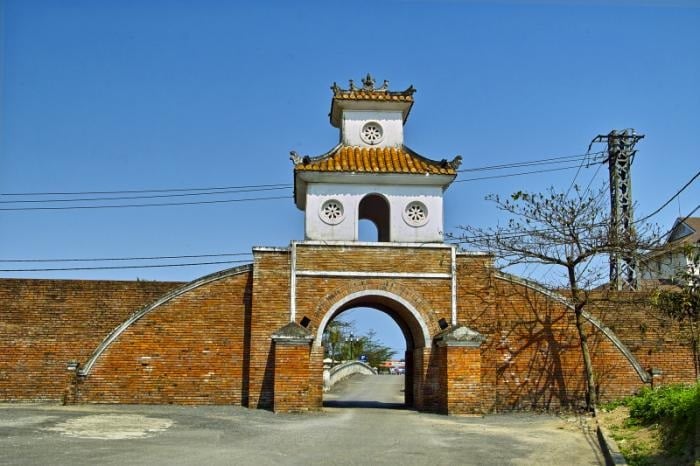
Dong Hoi Ancient Citadel is a part of the overall historical military relics of Dong Hoi during the Trinh-Nguyen conflict period, built on a key land area of the trans-Vietnam road from North to South. Along with its favorable geographical position, bordering the Nhat Le river and estuary on the East, serving as both a place for reinforcements and contributing to stopping the enemy's waterway attack, this place has marked many events. important history, marking the victory in the Northern advance of the 9 Nguyen Lords, ending 200 years of civil war. At the same time, Dong Hoi citadel also marked many victories of the army and people of Quang Binh through two holy resistance wars of the nation. Dong Hoi Citadel was started construction in the 10th year of Gia Long (1812). The citadel was built on the land where Lord Nguyen Phuc Nguyen built Tran Ninh fortress (also known as Dao Duy Tu fortress - 1631) and Dong Hai fortress (1774) during the Trinh-Nguyen war. At first, the citadel was built of earth, but during the reign of King Minh Mang, he asked a French officer to redesign it and build it with bricks in 1824 according to the tapeless architecture, with the appearance of a military citadel, in the shape of a notch. 4 big zones, 4 small zones in the southwest-northeast and northwest-southeast directions. The citadel has 3 large gates north-south-east, on the gate there are 8-roof watchtowers, the citadel gate is built in a three-door style, connected to the outside by a brick bridge also built in an arch style across the moat. Outside the citadel, about 5-6m from the citadel is a 7 truong (28m) wide moat, the outside of the citadel is covered with additional 3 truong of soil, the citadel is built of bricks, mortar made of molasses mixed with sand, not plastered, bricks are baked. tall, large bricks are also called mallet bricks. In the year of the Tiger, 1842, King Thieu Tri, on his way to the North, passed the Tran Ninh citadel, changed its old name to Dinh Bac Truong Citadel and had it repaired. In 1885, the French colonialists attacked the Central region, Dong Hoi citadel became a place of defense and counterattack of the Nguyen Dynasty's army. On July 19, 1885, the French colonialists attacked Dong Hoi citadel for the second time and the citadel fell into French hands. During the Can Vuong movement, the army and people of Quang Binh joined the insurgent army led by Nguyen Pham Tuan who broke into Dong Hoi citadel three times in January, June, and August 1886 to attack French soldiers, causing them many losses. the seventh. During the anti-French period, Dong Hoi citadel was a place to gather soldiers, a rendezvous point for people who dared to live and sacrifice for the Fatherland. Most of Dong Hoi citadel was destroyed during the French colonial period. In the resistance war against the US, with the purpose of leveling and destroying, turning this place back to the Stone Age to prevent reinforcements from the Northern rear to the Southern battlefield, US imperialism rained down on Dong Hoi. tens of thousands of tons of bombs and ammunition and destroyed part of the ancient citadel. Today, Dong Hoi citadel is only about 1,087m long with 15 zigzag sections in the shape of star teeth. The southern part of the citadel has 2/3 remaining relatively intact, the eastern part of the citadel has 3 gates, 2 south and north bridges have collapsed. Completely, the clearest view from the map is a moat around the citadel according to ancient architecture. Although much destroyed during two wars, Dong Hoi citadel still retains its essential original elements. According to the assessment of researchers, over time Dong Hoi citadel has been a witness and also a historical record marking a period of heroic struggle of the people of Dong Hoi - Quang Binh and the whole country in the fight against enemies. inside and outside to protect the integrity of Vietnam's territory. With its importance as a relic that has existed for more than 200 years, and is an important historical evidence of the land of Dong Hoi - Quang Binh, the Ministry of Culture, Sports and Tourism has classified Dong Hoi as one of 32 works. in the list of key cultural projects invested in from 2001-2010. Source: Quang Binh Newspaper
Quang Binh 1732 view
General Information Station A72 is located in the cave system of An Bo mountain, Ngan Thuy commune, Le Thuy district, Quang Binh province. This is the place that marks the silent victories, the spirit of determination to win, not afraid of hardships and sacrifices, and the resilient will of communication officers and soldiers in the people's resistance war against America to save the country. our clan. A72 is an important general station of Information Regiment 136, Communications Command, located in the An Bo mountain area, Ngan Thuy commune (Le Thuy) during the resistance war against the US to save the country. In the years 1966-1967, when the resistance war against the US to save the country entered a new, more drastic phase, the Ministry of Defense decided to build an additional communication line from North Nghe An to the northern bank of Ben Hai River. From this axis there will be many branch roads radiating to the areas for the General Command of the Vietnam People's Army to directly direct the southern fronts of Military Region 4, the Tri Thien front, and the Truong Son Army Command. (Group 559), Transport Group 500 of the Ministry of Transport and the Southern Laos front. Accordingly, the Department of Information and Communications (the predecessor of the later Communications Command) decided to establish Company 7 under the 136th Information Regiment, managing and exploiting the bare wire line of more than 300 kilometers. from Giang Son-Nghe An to high point 316-Vinh Linh. This route has 3 service stations, all in Quang Binh: A69 in Len Ha - Tuyen Hoa; A70 in Khuong Ha-Bo Trach and A72 in An Bo-Le Thuy. On January 7, 1967, at An Bo mountain cave, Ngan Thuy commune, General Information Station A72 of Company 7, Regiment 136, Communications Command was established. The A72 service station has up to 50 high-frequency telephone circuits, 28 three-way locomotives of various types and 2 100-digit switchboards. In addition to the task of ensuring communication for battlefield directions, A72 is also a reception station for agencies of the Ministry of Defense and high-ranking envoys of the Party and State to directly monitor and direct campaigns. This place became the campaign command center. The work of officers and soldiers of Station A72 increased by 7-8 times compared to normal. General Commander-in-Chief Vo Nguyen Giap was in the cave in the Command Post, General Information Station A72 area, with the generals who directly commanded our troops and people to fight in the "Road 9-Southern Laos Campaign". history. Completely defeated "Operation Lam Son 719" by the US imperial army and the puppet troops of the Saigon government. A resounding, most heroic victory in the history of our nation's resistance war against America. Including the significant contribution of officers and soldiers of General Information Station A72, ensuring absolute safety for the Command Post of General Commander-in-Chief Vo Nguyen Giap, maintaining communication in all situations. most fierce. In December 1982, in response to the need for force organization, the Ministry of National Defense merged Regiment 136 into Regiment 134, unifying the task of ensuring wired communication from the North to the Central region. From 1967 to 1982, General Information Station A72, Company 7, Regiment 136 has grown significantly, successfully completing the task of ensuring communication, contributing to the fighting career of building the Information Force. heroic communications, heroic Vietnamese People's Army. The regiment was awarded the First Class Victory Medal by the Party, State and Army; Company 7 was awarded the title of Hero of the People's Armed Forces; The A72 Information Station in Ngan Thuy commune was awarded the title of National Historical-Cultural Monument by the State. Source: Quang Binh Tourism Newspaper
Quang Binh 1727 view
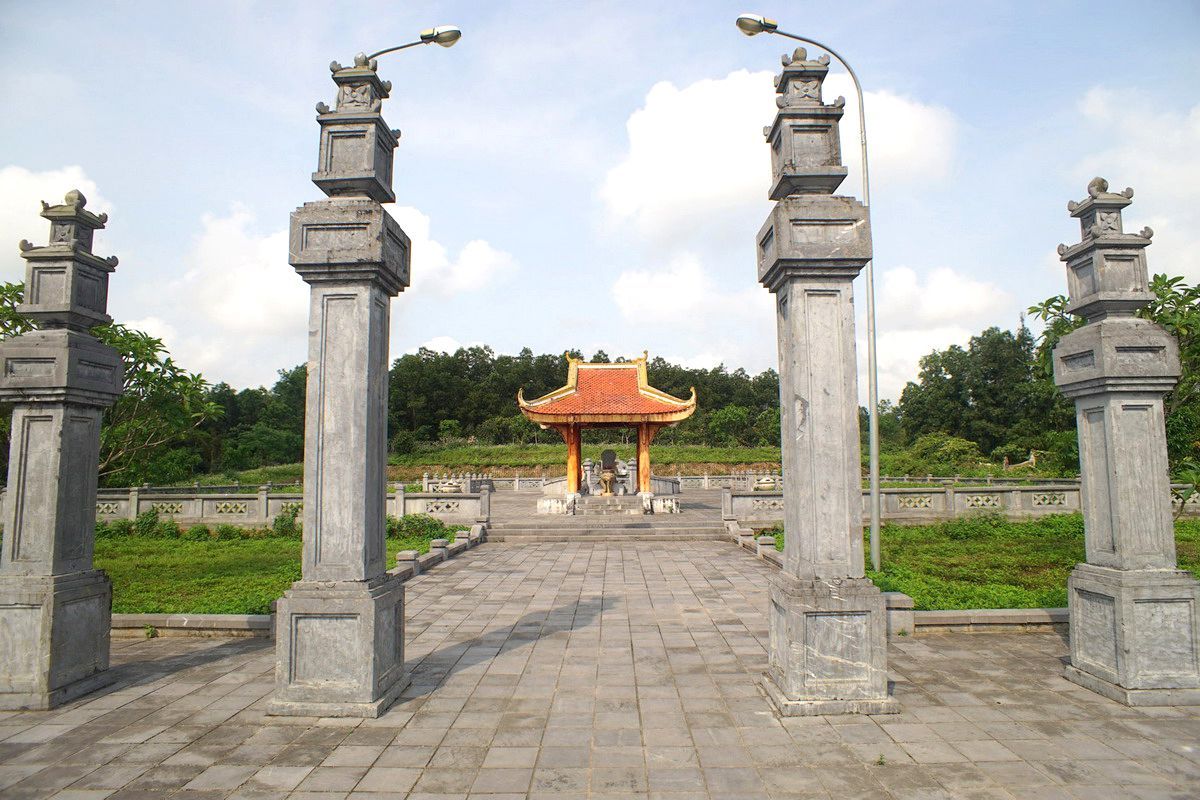
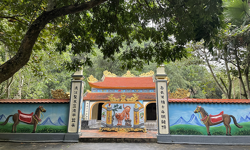
Nguyen Huu Canh's mausoleum is located on a high, airy hill of the An Ma mountain range in Truong Thuy commune, Le Thuy district. Nguyen Huu Canh was a mandarin who had great contributions under Lord Nguyen in fighting the enemy, opening up the land, and shaping the Vietnamese territory into a unified country. Nguyen Huu Canh was born in 1650 in Phuoc Long village, Chuong Tin, Phong Loc district (now Van Ninh commune, Quang Ninh district, Quang Binh province). He was awarded the title Le Thanh Marquis, Khai Quoc Cong Than, listed as the Superior Cong Than and worshiped at Thai Mieu. Nguyen Huu Canh is the third child of famous general Nguyen Huu Dat. Belonging to the lineage of the general's family, his ancestor was Dinh Quoc Cong Nguyen Bac, - the founder of the country during the Dinh dynasty. – Nguyen Huu Canh is also the 9th generation grandson of Nguyen Trai, – the founder of the Le Dynasty. Born in a traditional family and raised during the Trinh - Nguyen period, Nguyen Huu Canh's talent was soon revealed. At the age of twenty, Nguyen Huu Canh was famous throughout the region for his excellent martial arts skills. He followed his father to fight everywhere and made many achievements, so Lord Nguyen conferred the position of Cai Co. He has a heroic physique, dark skin, and was born in the year of the Tiger, so people call him by the nickname "Black Tiger". History also records that he many times led troops to suppress the Champa Dynasty and harass the South. In early 1692, Lord Nguyen sent Nguyen Huu Canh as General of the Army along with advisor Nguyen Dinh Quang to bring troops to balance the border and establish Thuan Thanh town (present-day Ninh Thuan, Binh Thuan). As soon as pacification was completed, a group of Qing people, led by Aban, incited factions to rebel. Nguyen Huu Canh received orders to suppress the rebels, bring security to the people of the county and was appointed to guard Binh Khuong palace (also known as Binh Khang, now Khanh Hoa - Binh Thuan region). In 1699, Chan Lap King Nac Thu (some books say Nac Ong Thu) led his army to attack Dai Viet. Lord Nguyen Phuc Chu sent Nguyen Huu Canh as the army commander, taking care of defeating and pacifying the people. Nguyen Huu Canh went straight to La Bich citadel (Nam Vang), defeating Nac Thu's army. In April of the year Canh Thin (1700), Nguyen Huu Canh fell ill. May 16, 1700. Nguyen Huu Canh died in Sam Giang (Rach Gam). In 1802, Nguyen Huu Canh's remains were brought back to be buried by descendants in Truong Thuy commune. Currently, in the grounds of Nguyen Huu Canh's Tomb in Quang Binh, there is a very valuable stone stele. Nguyen Huu Canh's tombstone is about 1.2m high, carved from green stone (marble). After his death, the people of the South in general and especially the Mekong Delta provinces set up temples to worship him in many places. Although several centuries have passed, the name and career of Nguyen Huu Canh are still forever engraved with the Vietnamese people in general and the people of Quang Binh in particular. "Thanh Marquis Cong Le went to open the land, thousands of years later, descendants will always remember" On March 25, 1991, Nguyen Huu Canh's mausoleum was ranked by the State as a national historical relic. Source: Quang Binh Tourism
Quang Binh 1704 view
Located in Giao Te village, Duc Ninh, only 3km west of Dong Hoi city center, the National Historical Site, the Exchange - Experts agency (referred to as Quang Binh Exchange Zone) was established. dated August 21, 1954 and dissolved in July 1988. During 34 years of carrying out its diplomatic mission, this agency has thoughtfully welcomed over 450 domestic and foreign delegations. With its enormous historical role, Quang Binh Economic Zone was recognized by the Ministry of Culture, Sports and Tourism as a national historical site on December 4, 1998. When newly established, Quang Binh Exchange Zone was headquartered in Dong Hoi town. In the early period, the Quang Binh Economic Zone was built in Dong Hoi town. The mission of the Economic Zone at this time was to transport delegations of Southern officers and soldiers to the North, and delegations of visiting and industrial guests. work in the province. In 1964, when the American enemy frantically waged a war of sabotage in the North, in a rain of bombs and bullets, to ensure the transportation and service of guests, Quang Binh Relations Department continuously moved its headquarters to receive guests as well as serve guests. It is necessary to divide communication activities into small groups, located in many localities in the province such as Duc Ninh, Con, Nghia Ninh, Ly Ninh, Bo Trach... In 1970, the Quang Binh Administrative Committee decided to begin building the Exchange Zone at Duc Ninh Hill. The construction was unfinished when the US imperialists returned, continuing to expand the war with increasingly cunning plots. The Economic Zone continued to evacuate to the Con area. In 1973, when the Paris Agreement had just been signed, the Party Central Committee and the Government instructed Quang Binh to urgently build a diplomatic zone in Duc Ninh to serve the international fixed team stationed in Dong Hoi to monitor the Agreement. Geneva. With all the chaos and deprivation of a province that had just escaped a fierce and long war, Quang Binh quickly began implementing new tasks. After only a short time, the Economic Zone was basically completed and put into operation. With a campus of nearly 4 hectares, the Communication Area is divided into many areas such as: motel area for domestic guests, motel area for foreign guests, office, hall, kitchen... In May 1973, 19 international diplomatic delegations and the delegation of the Provisional Revolutionary Government of the Republic of South Vietnam - led by Ms. Nguyen Thi Binh and Mr. Trinh Dinh Thao, Nguyen Huu Tho, Thich Don Hau... met came to the Economic Zone to prepare for the launch of the Provisional Revolutionary Government of the Republic of South Vietnam - Vietnam. In September 1973, the Diplomatic Area was honored to welcome and serve a high-ranking delegation of the Cuban Party and State led by Comrade Black Catsitro. Here, President Phi Den-Catsitro stayed for many days to visit the liberated area in Quang Tri. Also in this economic zone, the top leaders of Laos, Cambodia, Czechoslovakia, the French Communist Party... came to work and stay here. Many high-ranking leaders of our Party and State such as comrades Le Duan, Truong Chinh, Vo Nguyen Giap, and Le Duc Tho once stayed in the exchange area to work. At the Exchange Zone, many historical events have taken place, many guidelines and policies of the Party and State on liberating the South have been initiated... Source: Quang Binh Tourism
Quang Binh 1693 view
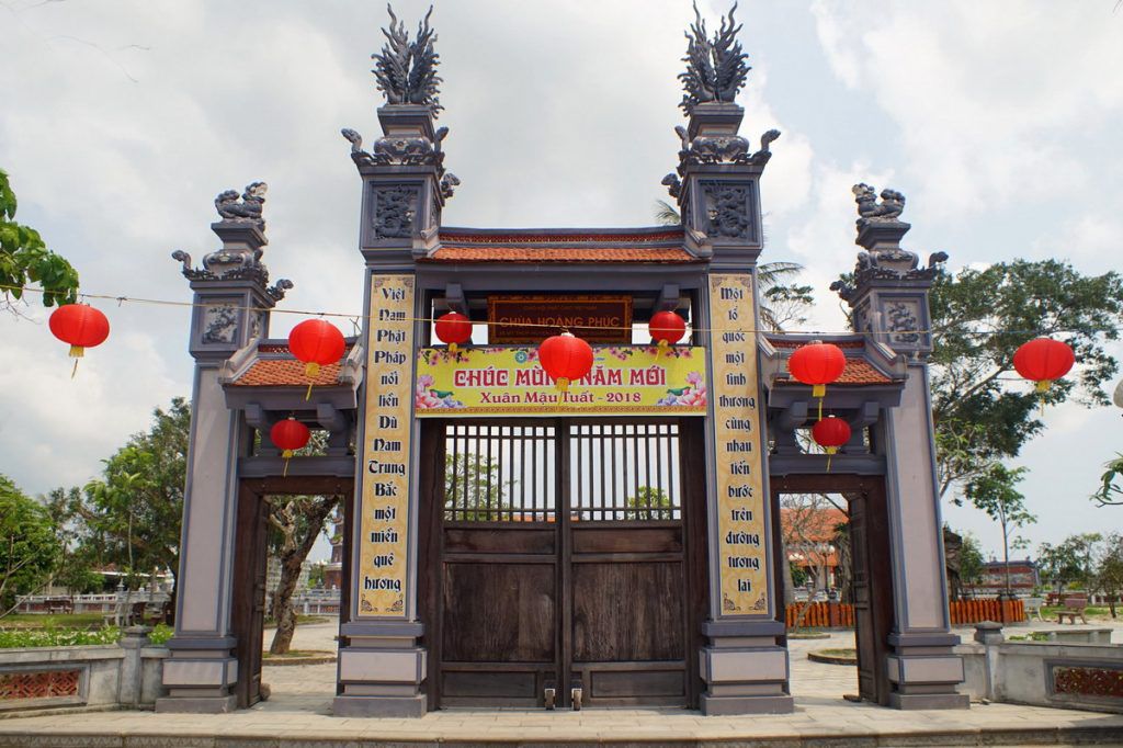
Hoang Phuc Pagoda originated as Tri Kien pagoda, Kinh Thien pagoda, commonly known as Tram pagoda or Quan pagoda, in Thuan Trach ward (now My Thuy commune), Le Thuy district, Quang Binh province. After more than 700 years of history, Hoang Phuc Pagoda still exists and develops with many restorations and restorations. In 1609, Lord Nguyen Hoang rebuilt the pagoda on the old foundation and named it Kinh Thien In 1716, Lord Nguyen Phuc Chu visited the pagoda, repaired it, placed two horizontal panels representing "Kinh Thien Tu" and "Unparalleled Blessed Land", and controlled 5 pairs of tureens hanging in the pagoda. In 1821, King Minh Mang visited the pagoda and changed the pagoda's name to "Hoang Phuc Tu". In 1823 and 1826, the king gave 250 taels of silver to repair the pagoda. In 1842, King Thieu Tri, who lived in Bac Tuan province, visited Hoang Phuc pagoda and granted 300 taels of silver to restore the pagoda. Hoang Phuc Pagoda is not only a place to worship Buddha, a place to propagate Buddhism, but also a place associated with typical historical events of the homeland through the ages. During the pre-uprising period, with its location in a semi-mountainous area, surrounded by luxuriant trees and bordering My Tho - Trung Luc, the first Communist Party cell in the south of Quang Binh province was born (1931). ). Hoang Phuc Pagoda has become a revolutionary base, harboring and protecting cadres who come here to operate. Especially in 1943, comrade Bui Trung Lap, an officer of the Central Party Committee, also came here to meet with revolutionary cadres and propagate the Party's policies and fighting spirit to the masses. In early May 1945, according to the instructions of the superiors, the Village Uprising Campaign Committee was established, Hoang Phuc Pagoda was chosen as the meeting place to implement the superiors' uprising instructions and prepare forces. weapons led to an uprising to seize power on August 23, 1945. During those years of fierce struggle, Hoang Phuc Pagoda was a place to hide weapons, a place to recruit and train militia and self-defense forces, and a place where higher-ranking military officers gathered and organized raids. locally, contributing to the overall victory of the resistance war against the French colonialists in Quang Binh. During the resistance war against the US to save the country, My Thuy was one of the communes directly adjacent to the major southern front line. This is the rear base of battlefield B, a gathering place for goods, weapons, and a stopping point before entering the Southern battlefield. Buddhists in Hoang Phuc Pagoda joined local people in fighting and serving in local battles. In 1967, Hoang Phuc Pagoda was destroyed by bombs and bullets after American air strikes. Previously, the system of worship statues at Hoang Phuc Pagoda had quite a large number, designed on 7 worship levels. However, currently the pagoda only has 7 statues of various types with different materials, manufacturing techniques, designs and decorative arts. Among them, there are 5 bronze statues and 2 wooden statues. In particular, the pagoda also preserves a large bell cast in the 20th year of Minh Mang's reign (1839) named Hoang Phuc Linh Chung. In November 2014, the restoration project of Hoang Phuc Pagoda was carried out according to the ancient pagoda style of the Tran Dynasty, including: Three external gates, Three internal gates, Buddha tower, Three jewels, Patriarch church, left and right corridors, gold ammification and other auxiliary works. With the historical values of the pagoda, on December 9, 2015, the Ministry of Culture, Sports and Tourism ranked Hoang Phuc Pagoda as a National Historical Site. Source: Quang Binh Tourism
Quang Binh 1600 view
Minh Le communal house belongs to Minh Le village, Thuan Phi district, Quang Trach district, now belongs to Minh Le village, Quang Minh commune, Quang Trach district, Quang Binh. The village communal house is located 400m northwest of the commune People's Committee headquarters, 6km southwest of Ba Don town, 400m northeast of Minh Le station. Minh Le Communal House was built in 1464 under the reign of King Le Thanh Tong, the 5th emperor of the early Le Dynasty. This is a sacred place of worship and also a place of religious cultural activities, and a witness of history. Minh Le village communal house is a place to worship village tutelary god Truong Hy Trong and four ancestors: Truong, Nguyen, Hoang, Tran. He is the second son of Truong Cong Lang - a talented general of King Le Loi. Truong Hy Trong's real name is Truong Cong Chan, following in his father's footsteps, he achieved many great victories in the fight against the Champa army and defending the Thuan Hoa region. He and his three families, Nguyen, Hoang, and Tran, had the merit of recruiting people and exploring the southern land to found Thi Le commune, including 5 villages: Minh Le (Quang Minh), Doai village (Dien Truong-Quang Son), Vinh Ninh. (Hoa Ninh-Quang Hoa), Vinh Phuoc, Vinh Loc (Quang Loc). In 1493, after the battle at Thanh Loi, he was seriously injured and died in his hometown of Minh Le. King Le was extremely sorry for the country's talents, so he ordained him as "Marquis of the Governor". In the second year of Quang Trung, he was awarded the title Trung Lang Thuong General. Through many events, ups and downs of history, Minh Le Communal House still stands the test of time with extremely great cultural and spiritual values for the people. Minh Le communal house was elaborately built from blocks shaped like dragons and phoenixes, to paintings and carvings, expressing colors, especially the arrangement and structure of the doors, consecutive arches, doors sunk into the wall. , doors connecting rooms, thick walls, slightly low in height. Arranged in symmetry, the back pavilion is made in the style of a domed roof that successively forms two arches, the deeper it gets, the lower it gets. The fierce dragon face, rough dragon body, and strong dragon legs represent the powerful force of the Nguyen feudal regime. Minh Le communal house is a relic area including: gate, citadel, courtyard, screen, middle communal house and rear communal house. The central communal house has four roofs, two front roofs and two gable roofs. On the communal house, in the middle of the roof there are two dragons flanking the moon, the two corners of the roof are images of two gliding dragons stylized with flowers and leaves, the dragon's head hidden in the leaves. The four corners of the roof are curved dragon shapes, lifting the roof gracefully. Between the two front roof lines are the shapes of unicorns. The middle space is connected to the two side rooms by three arched doors and is connected to the back pavilion by also three arched doors. Minh Le communal house is associated with many typical historical events of the homeland through the ages. Like during the campaign to establish a party, the uprising to seize power in 1945, or the resistance war against France and America to save the country. In 1992, Minh Le communal house was recognized as a national historical and cultural relic. Every year during the holidays, children and grandchildren in the village from all over the country come here to offer incense. Source: Quang Binh Tourism
Quang Binh 1586 view
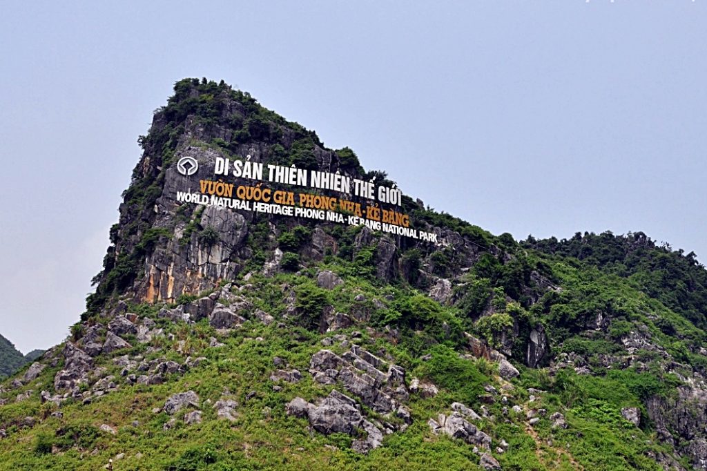
Phong Nha Ke Bang National Park Relics is located in the mountains of Central Vietnam, a natural wonder located southwest of the Gianh River. With a unique geographical location, Phong Nha Ke Bang National Park relic borders Laos to the West and Southwest; The north borders Thuong Hoa commune, Minh Hoa district; The Southeast borders Truong Son commune, Quang Ninh District, Quang Binh province. Phong Nha Ke Bang National Monument is not only the largest limestone mountain in the world; This place also possesses magnificent caves, mysterious rivers and beautiful waterfalls. From famous caves known since the 1920s and exploited for tourism since the French colonial period, to recent discoveries from the British Royal Cave Expedition, this monument still fascinates people. fascinated by the beautiful scenes that nature bestowed on this place. The cave system in Phong Nha Ke Bang National Park is the oldest cave in Southeast Asia, with natural impacts from more than 35 million years ago. This is also where diverse ecosystems are formed thanks to the largest limestone block in Southeast Asia, creating favorable conditions for the development of primary forests. With more than 15 habitat types and 10 important vegetation types, Phong Nha Ke Bang covers 83.74% of its area with primary forest. What makes Phong Nha Ke Bang relic stand out is not only its poetic natural landscape, but also its biodiversity. With more than 2,600 species of plants, 735 species of vertebrates and 369 species of insects, including many rare species listed in the red book. This place is also home to many endemic species of primates and bats, contributing to making the ecosystem here rich and diverse. In addition to biological value, Phong Nha Ke Bang National Park relics also preserve many historical relics. From ancient cultural vestiges of the Cham people, ancient Vietnamese, to memorabilia of the resistance war against the French and Americans. All of this has given the Phong Nha Ke Bang relic immense historical and cultural value. Thanks to that, in July 2003, Phong Nha Ke Bang national park relic was recognized by UNESCO as one of the world's natural heritage sites. On August 12, 2009, the Prime Minister of Vietnam recognized Phong Nha Ke Bang National Park relic as one of the Quang Binh historical relics ranked as a special national historical relic. Source: Quang Binh Tourism
Quang Binh 1568 view


 vn
vn en
en ja
ja ko
ko zh
zh VIP member benefits