Explore the history, culture, people and beautiful landscapes of Vietnam on the 63Stravel travel app
Download the 63stravel app


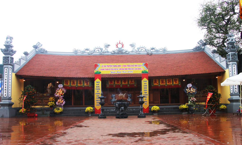
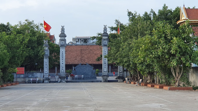
Trieu Khe communal house was built in 1901 (Tan Suu), worshiping two village Thanh Hoang, Tran Trieu Kham Minh Thanh Vu Hien Dao An Sinh Vuong Tran Lieu and Emperor Tran Trieu Anh Tong. Every year on January 11-12, the people of Trieu Khe village organize the traditional festival of Trieu Khe communal house - pagoda to present to the two Village Gods about the achievements the villagers have reaped during the year and honor their merits. Tran Dynasty led the people to defeat the Mongol invaders and keep the territory intact in the 13th century. At the same time, we convey the people's prayers for good health, peace, happiness, and success to continue contributing to protecting and building the homeland and country. The cluster of historical and cultural relics of Trieu Khe communal house and pagoda was ranked as a provincial relic in 2006. After 122 years of existence, the communal house has now seriously degraded. To preserve cultural traditions, respect for the village's Thanh Hoang worshiping place, promote the value of relics associated with the complex of the Tran Dynasty Special National Relic Area in Dong Trieu, with permission from the Provincial People's Committee, May In June 2023, the groundbreaking ceremony to renovate Trieu Khe communal house's provincial-level historical and cultural relic will be held. After 6 months of construction, the project to renovate Trieu Khe communal house has completed phase 1 with a total cost of over 6.2 billion VND from socialized sources. When Trieu Khe Communal House was inaugurated and put into use, it will continue to meet the needs of spiritual and religious cultural activities, express respect, and show gratitude to the people for their great merits towards the two Village Gods. in the work of protecting and building the homeland and country, while creating a unique cultural and historical mark of the locality. Thereby, contributing to strengthening the education of historical and cultural traditions for the young generation, promoting the development of spiritual cultural tourism in the locality. Source Quang Ninh province electronic information portal.
Quang Ninh 866 view
La Pagoda, the literal name is Tam Thanh Tu, is located in Thau Dau hamlet, Cam Lien village, Cam La commune. The pagoda was built in the 16th century, during the Nguyen Dynasty and is a place of cultural activities for Buddhists. La Pagoda also preserves many artifacts that are typical artistic sculptures of the Nguyen Dynasty style. In addition to the cultural values preserved through artistic sculptures and worship objects, La Pagoda is the center of religious activities of the villagers, as well as the center of village cultural community activities. With those functions, La Pagoda is not only a place to serve the spiritual beliefs of the villagers but also plays a role in connecting and gathering traditional cultural values, and is a place where community cultural values take place with ceremonies. folk association. The annual La Pagoda Festival takes place from the 5th to the 6th of the first lunar month. In addition to worshiping and visiting the pagoda, people can also participate in games such as swinging, singing, and playing chess. With the above cultural values, on December 28, 2006, the Provincial People's Committee decided to classify La Pagoda as a provincial cultural and historical relic according to Decision No. 4225-QD/UBND. This is a cultural activity of the village that contributes to enriching the national cultural identity. Source Quang Ninh province electronic information portal.
Quang Ninh 836 view
Lai Pagoda (also known as Linh Ngai Tu) is a pagoda located in Vi Khe village - Lien Vi commune, Quang Yen town, Quang Ninh province, administratively located in Phong Coc ward. Lai Pagoda's literal name is Linh Ngai Tu (Linh Ngai Pagoda), Ngai is the throne hand position. The two words Linh Ngai are explained by the fact that the Van River radiates into two branches of the Cai Dong River and the Vi Khe River, forming a position of arms embracing this land, also known as Linh Ngai land. The name of the temple comes from the name of the village. Lai village was formerly a mudflat at the mouth of Bach Dang river. People here live year-round by fishing, and at night they rest on their boats. Around the time of King Le - Hong Duc era, Pham Thanh Lanh, a native of Quang Lang, gathered fishermen in the area to build dikes, encroach on the sea, build houses and gates on the shore, and establish a village called Lai village. When life was crowded, they built a pagoda to meet their religious needs and took the name of the village as the common name for the pagoda. The two words "Lai Pagoda" have not changed until now and have been deeply ingrained in the minds of the people here. Lai Pagoda was built quite early, from the mid-sixteenth century. Initially made of bamboo paintings and clay walls to worship Buddha. In the 2nd year of Hung Tri (1589), the pagoda was restored, created Buddha statues, and rebuilt more spaciously by the associations of monks, nuns, and donors in Vi Duong and Vi Khe communes. The pagoda is located on a plot of land with a total area of 5,767 m², surrounded by fertile rice fields. The stele "Linh Ngai's inscription" engraved in 1589 reads: "Linh Ngai Pagoda is located on the land." Linh Ngai, Vi Khe village, Vi Duong commune, Yen Hung district, surrounded by Buddha fields. In the past, ancient people built pagodas and planted fields, and saw a bamboo castle growing lushly like a path leading to Prajnaparamita. , is the country's steadfast wealth, the number one scenic spot of Hai Dong... After being rebuilt, Linh Ngai Pagoda is magnificent, the Buddha statue is revered, and people worship it. This is a vast land located in the Western town, is a scenic spot of the Southern country...". The good news spread far and wide, after Lai Pagoda was completed, this place became more and more crowded, bustling, sacred, Buddhists took refuge, monks and nuns, all directed their good hearts to the Buddha realm, contributing and making contributions. of hoping for eternal happiness for children and grandchildren. The pagoda has been restored and repaired many times in the following years: Vinh Huu the 2nd (1716), Thanh Thai the 19th (1907), Khai Dinh the 3rd (1918), Khai Dinh the 10th (1925), Bao Dai the 3rd. (1928). Lai Pagoda has been the abbot seven times, and the monks are all devout. There are monks who also participated in revolutionary activities and were awarded Orders and Medals by the State during the resistance war against the French colonialists. Up to now, although time has changed the old pagoda's scenery a lot, overall Lai Pagoda still retains the ancient features of the ancient pagoda: five main pagoda compartments, five ancestral house compartments, gardens, and towers are arranged. The department follows the style of pre-Buddha and post-Patriarchs. The pagoda faces northwest, although not in the direction of the usual Vietnamese pagodas, but it is a very beautiful position, with the Van river dividing into two branches, Cai Dong and Vi Khe, hugging the whole land like the arms of a sturdy throne. These two river branches curve softly as if two dragons were playing with water around the pagoda (two dragons playing with water). On the other hand, when the tide rises, the water in the sea through the Cai Dong and Vi Khe rivers converge and meet at the Van River (in front of the pagoda door). At low tide, the water in the Van River radiates out into the Cai Dong and Vi Khe rivers to flow into the sea. Day after day, it radiates and then gathers into the mouth of the water according to the operation of the earth like the Buddhist wheel of reincarnation. Lai Pagoda still retains 125 intact artifacts, including 6 wooden statues carved during the Mac Dynasty (3 Tam The statues, 1 A di Da statue, 1 Quan Am Bodhisattva statue, 1 Sakyamuni statue. ), 1 stone stele of the Mac dynasty made in the 2nd year of Hung Tri (1589), 1 stone incense stick in the 12th year of Vinh Thinh (1716), 28 statues carved in the Nguyen dynasty (2 Avalokiteśvara statues, 4 statues Thien Vuong, 1 statue of Maitreya, 2 statues of Tuyet Son, 1 statue of newborn Shakyamuni, 1 statue of Duc Ong, 2 statues of the Monsignor's assistant, 1 statue of Mother Goddess, 7 statues of Co, Uncle..., 6 panels stone stele, a bronze Nine-Dragon tower) and a large bronze bell cast in the 19th year of Thanh Thai (1907) by the Nguyen Dynasty, along with many valuable worship objects of the Le and Nguyen dynasties. Legend has it that inside the temple grounds there is an underground tunnel to hide many letters, weapons and hiding places of revolutionary cadres during the years of resistance against the French. With its historical and cultural values, Lai Pagoda has been recognized by the People's Committee of Quang Ninh province as an architectural and artistic relic according to Decision No. 1870/QD-UBND, dated July 27, 2000. Source Quang Ninh province electronic information portal.
Quang Ninh 920 view
Yen My Pagoda, also known as Phuc Khanh Pagoda, is located deep in Tu Xa village, now Tan Tien village (Le Loi commune, Ha Long city). This is considered one of the ancient temples that still retains many unique features to this day. According to relic records, the pagoda was built around the late 18th and early 19th centuries. In the 8th year of Tu Duc (1854), the deputy warden of Huong Ly Dich together with the abbot of the pagoda had the harem repaired. Ms. Dong Thi Dieu, a villager, advanced 30 francs of money plus 3 acres of her family's fields to fund the repair of the pagoda. From then on, the pagoda went through many more renovations, once in the 16th Thanh Thai period, once in the 6th Bao Dai period... Yen My Pagoda is located on a high land with an extremely favorable terrain, converging the aura of heaven and earth. The pagoda faces south, facing the Dharma. "The male saint faces the world" meaning that the saint turns his face to the south and listens to the world's words. In front are two flanking mountains and a river in the middle flowing into Cua Luc River. The North and East are adjacent to residential areas, and the West is adjacent to fields. According to feng shui, this terrain has water gathering in front, behind it has occiput, on the right side there is left and right, it is an ideal land position that not every temple has. The pagoda is designed in the shape of a nail (like the letter T), the front hall consists of 3 compartments, behind is the harem with 2 vertical compartments. Previously, the pagoda had a system of post-Buddhist houses, monk houses and other architectural works that were relatively grand and large-scale. Through time and war, the pagoda now only has a front hall and a harem. The pagoda has now been rebuilt but still retains the traditional architecture on the old structure. After nearly 2 centuries, Yen My Pagoda still retains a relatively complete system of Buddha statues and worship objects, including 23 wooden statues, 1 plaster statue and 1 stone statue. The statues are intricately carved in the shallow carving style of the Nguyen Dynasty. The statues of Tam The, newborn Shakyamuni, the statues of Jade Emperor, Nam Tao, Bac Dau, statues of Ananda, Ca Diep, Thai Thuong Lao Quan, Bodhisattva Avalokiteśvara... each statue has a different appearance and style. own way. In addition to the main hall worshiping Buddha, currently Yen My Pagoda also has a place to worship the Mother Goddess with an architecture similar to the place to worship the Three Jewels. The temple grounds were also expanded with a total area of about 1000m² including gardens and other auxiliary works. Yen My Pagoda was recognized by the Provincial People's Committee as a provincial-level historical and cultural relic in 1999 and is a spiritual destination chosen by many tourists when coming to Le Loi commune, Ha Long city. Source Quang Ninh province electronic information portal.
Quang Ninh 1019 view
Hoang Xa pagoda communal house is also known as Nhi communal house. Previously, Hoang Xa commune had two communal houses, the communal house in the lower hamlet was called Ha communal house or Nhi communal house, to the left of the communal house there was a pagoda called Hoang Hoa Tu. During the resistance war against the French colonialists, Hoang Xa pagoda was a revolutionary base, where fierce battles took place between us and the enemy. In 1954, the last enemy unit withdrew from Dong Trieu land. To commemorate the heroic martyrs in the two resistance wars against the French and the Americans, the government built a great memorial here. Currently, Hoang Xa communal house worships the Five Great Kings of Cao Son who have been ordained as tutelary gods of the village through the dynasties: Duong Canh Ngu Loi Noi Dai Vuong; On the scene of the Great King's Court; In the presence of the great king of the divine emperor; Great King Hong Lay; Luong Hong Chau Ngoc Thi Nuong. Hoang Xa pagoda relic cluster includes works: three gates; family; pagodas and martyrs' memorials. Currently, Hoang Xa pagoda is in the process of preservation and renovation. After many restorations, in 2001 the communal house was rebuilt on the old foundation, with a nail-shaped (J) architecture consisting of three front rooms and one back room, roofed with western tiles. The pagoda was renovated in 1997 and also has a nail-shaped (J) architecture, three front rooms and one back room. The martyrs' memorial was built in 1997 between the communal house and the pagoda. Through time and war, Buddha statues and worship objects in temples and pagodas were damaged and many were lost. Currently, there are a total of 15 stone steles, including 4 steles bearing the Canh Hung era, the reign of King Le Hien Tong (1740-1786), 11 steles bearing the era names of the Nguyen dynasty kings. Due to being cleaned outdoors, the above steles are worn, the letters are faded, difficult to read and there are still many stones that stand at the base of the pillars that are intact or many that have been broken. These are evidence confirming the cultural imprint of the ancient communal house and pagoda in Hoang Xa. Hoang Xa village temple festival is held on January 9-10 every year. In addition, there are Upper Dien and Lower Dien days, full moon weeks, first days, Buddhist holidays... all of which the villagers offer offerings to. At the festival, folk games and sports activities such as tug of war and football competitions also take place, attracting a large number of people and tourists to attend. With the value of the Hoang Xa communal house and pagoda relic complex, on December 28, 2016, the People's Committee of Quang Ninh province issued Decision No. 4423/QD-UBND, classifying the Hoang Xa communal house and pagoda as a historical relic. Provincial level. Currently, Hoang Xa pagoda is in the process of being preserved and embellished. It is in great need of the attention and merit of Buddhists from near and far and benefactors to make this cluster of relics spacious and prosperous. Source Quang Ninh province electronic information portal.
Quang Ninh 1038 view
Nhue Ho Pagoda has a history of about 400 years. As the preserved system of restored stone stele of the pagoda shows, on February 20, the 17th year of Chinh Hoa (1696), the pagoda was restored and repaired. So at least the temple must have existed before this time. According to old people, although it is a village pagoda, Nhue Ho Pagoda has always been cared for and repaired by village officials. The merit stele also records that at the end of the 17th century, many people offered money and land to donate merit to the temple. In 1786, mandarin Nhue Ho contributed to renewing the old temple, planting many trees to make the pagoda more airy. Master Hai Nha, from Quynh Coi, Thai Binh, donated 7 acres of fields to make incense and fire fields. On December 15, the 14th year of Minh Menh (1833), the elders, people of Nhue Ho and the abbot put in 15 strings of green money to cover the Buddha statue... Therefore, in the history of Nhue Ho pagoda, there was once a large scale. Large and spacious, including the worship house, ancestral house, model house, monk's house, ceremony house, kitchen, tower garden, beer garden, three gates, pagoda yard, pagoda fields, and orchard of the pagoda. ... The pagoda is located on a large area of land, surrounded by rice fields that radiate the fragrance of rice all year round. Every day, the temple never misses the sound of bells ringing, making the temple scene solemn and cozy. However, through many ups and downs of history, for a time the pagoda was much damaged. With faith and respect for the village's sacred pagoda, in 1995 Buddhists from near and far made merits and rebuilt the pagoda according to the old pagoda model. Up to now, the pagoda still retains the ancient and quiet features of an ancient pagoda with an architecture including a worship hall in the shape of the letter T, 5 front halls, a back hall, a kitchen, a beer garden, a tower and a communal house. The new village tutelary god was built in the style of pre-Buddha and post-god gods. Currently, Nhue Ho Pagoda still preserves 98 ancient artifacts. The most precious of these is the unique Buddha statue system, including 15 statues made of terracotta material from the Le Dynasty. According to the head monk of the pagoda, Thich Thanh Hai, this is a rare set of intact terracotta statues in the system of terracotta Buddha statues at Quang Ninh pagodas. The statues are meticulously carved with all different postures, shapes, facial expressions, and inner expressions. 3 statues of Tam The, 1 statue of Amitabha 145cm high, shoulder width 60cm. Although the head and right shoulder are damaged, this is still considered the largest statue among the Adi Da statues in Quang Ninh. 4 statues of the Four Heavenly Kings, 1 statue of Avalokiteshvara, 1 statue of Tuyet Son, 2 statues of Bodhisattva Avalokiteśvara, 1 statue of newborn Sakyamuni, 1 statue of Dharma Protector. The other 4 statues were made in the Tay Son dynasty, 2 statues were made in the early Nguyen dynasty. In addition, Nhue Ho Pagoda also has a system of valuable stone stele arranged in the right position along with many ancient worship objects, making the pagoda even more ancient. Among them, the oldest stone stele is made in the 14th year of Minh Menh (1833) and 1 stone stele is made in the 20th year of Minh Menh (1839). Nhue Ho Pagoda opens its festival from January 20 to 23 every year. On the festival day, many folk games take place here, and many worship groups from all over come to make offerings and offer incense. In recent years, Nhue Ho Pagoda has attracted a large number of tourists from all over to offer incense, visit the pagoda's landscape and participate in festival activities. Source Quang Ninh province electronic information portal.
Quang Ninh 971 view
The historical relic of My Cu Communal House is located in My Cu 1 Area, Hung Dao Ward, Dong Trieu Town, Quang Ninh Province. According to the Divine Legend of My Cu village, Me Son district, Dong Trieu district, My Cu village communal house worships eight village Thanh Hoangs: (1).Tam Giang Khuoc Dich (full name Truong Hat), (2). Kiem Tri Ton Dao, (3). Cao Son Cay Met, (4). Layman Venerable God, (5). Cao Son Dong Giac, (6). The god of Minh Man, (7). Cao Son Cay Vy, (8). Princess Ngoc Trinh. Also according to the divine legend, My Cu communal house has 14 ordinations of kings conferring on tutelary deities to be worshiped at the communal house, specifically three village gods: Cao Son Cay Met, Cao Son Dong Giac, Cao Son Cay. Vy are local Gods (nature gods), worshiped with the concept of "All things are polytheistic", and are not ordained. The honoring and worshiping of tutelary gods who are both human and natural gods at My Cu communal house has created a distinct feature between My Cu village and other localities in the province. My Cu Communal House faces West, has the Dinh script architecture and was built according to the traditional architecture of Vietnamese village communal houses including Bai Duong and Hau Palace. The courtyard is paved with red bricks. From the yard to the main hall, you have to go through two green stone steps (also the steps of the previous communal house) and a large veranda also paved with red tiles. The communal house still has relics of the My Cu village's Divine Relics, bowl palanquins, dragon communal palanquins, tablets, ordination boxes... which are important scientific bases showing the appearance and existence of the communal house. American Instruments in history. These relics not only show the scale and importance of the relic, and the interest of Vietnamese feudal dynasties in the Tutelary God worshiped at the relic, but also contain information about the past. The process of formation and development of relics and relics as well as the economic and social conditions in a certain period of local development. The tablets still remaining at My Cu Communal House are precious relics, unique and unique, typical of the Nguyen Dynasty's visual art, the carved lines are highly aesthetic like few other relics in the world. available in the entire province. According to My Con Village's Divine Legend: Every year, My Con communal house holds ceremonies on the 10th day of the first lunar month and the 1st day of the fourth month (lunar calendar). Currently, the people of My Cu village only maintain the My Cu communal house festival on the 9th day of the first lunar month (lunar calendar) every year. The communal house festival is organized including a ceremony and a festival. My Cu communal house festival is a cultural beauty with many lively rituals and games of the people. Each festival is an opportunity for people to participate in creating and enjoying culture, reviewing and promoting traditional cultural values in contemporary life. With those values, the historical relic of My Cu communal house, Hung Dao commune, Dong Trieu town has been ranked as a provincial-level relic in Decision No. 606/QD-UBND dated March 9, 2023 of the Chairman of the Committee. People of Quang Ninh province. The provincial-level relic ranking of My Cu Communal House relics creates an additional legal basis for the management, conservation, restoration and promotion of the relic's value, contributing to the preservation of cultural values and customs. of the people, protecting historical values during the formation and development of the monument, contributing to educating the tradition of "when drinking water, remember its source". Source Department of Culture and Sports of Quang Ninh province.
Quang Ninh 838 view
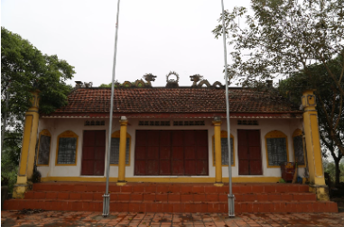
Binh Luc communal house is located in Binh Luc Ha area, Hong Phong ward, worshiping Kham Minh Thanh Vu Hien Dao An Sinh king Tran Lieu, father of Hung Dao king Tran Quoc Tuan. The stele in the relic grounds are all post-god stele, of which the earliest date is the 17th Chinh Hoa year of the Le Dynasty (1696), showing that the communal house was built before this year. Binh Luc communal house is one of the earliest communal houses built in the Northeast region, bearing the architectural style of village communal houses during the Le Trung Hung period. Architectural traces and relics show that the communal house was restored during the Nguyen Dynasty. According to the elders, by the mid-twentieth century, the communal house had seriously degraded, but due to difficult economic conditions, it could not be restored. In the 70s and 80s of the twentieth century, the communal house burned and completely collapsed. In 1995, the people built a small communal house with simple architecture on the ancient royal palace grounds to worship and serve the spiritual and religious needs of the community. This small communal house exists to this day. Source Quang Ninh province electronic information portal.
Quang Ninh 858 view
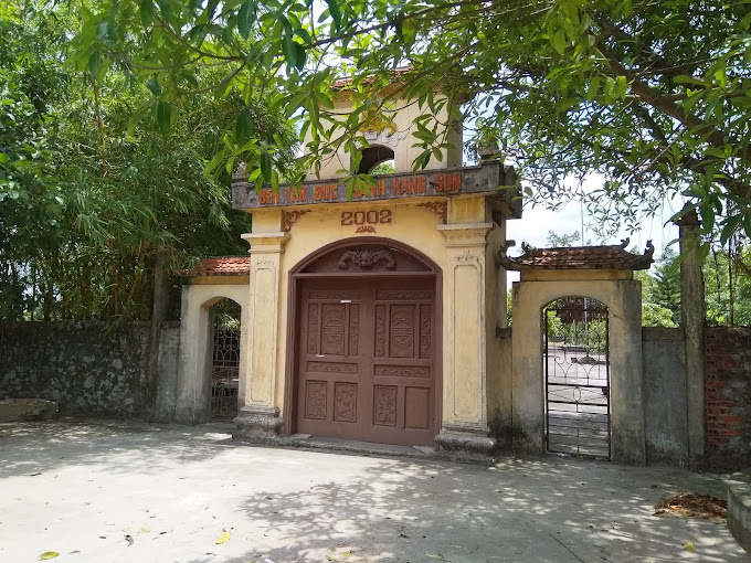
Hang Son Holy Temple belongs to a complex of historical, cultural, and revolutionary relics of outstanding value in Yen Duc commune such as Dong Thuy mountain, Con Chuot mountain, Con Meo mountain, Canh mountain, Hang 73, Canh Huong Pagoda, Thien Long Uyen... The above relics have been put into management and ranked as relics at all levels. According to legends and historical records of the formation of the Hang Son Holy Temple, it is said that there was a young man named Pham Chau, handsome and extremely intelligent, who rained to help the people, then transformed into a man named Pham Chau. turned into a carp and floated down the Ma River to Hang Son cave, dreaming for dignitaries of Yen Khanh and Quy Khe villages (Quang Yen) to come and find Hang Son. To commemorate their gratitude, the people of the two villages worshiped the Saint in Hang Son and called him the Saint of Hang Son. The temple is located in a correlation with the Hang Son cluster of historical, cultural and scenic relics in Phuong Nam ward, Uong Bi city. The temple was built during the Tran Dynasty. Here, Buddha and Mother Goddesses are also worshiped. This is a combination of Buddhism and the sacredness of the Vietnamese people's belief in God worship and Mother Goddess worship. The temple is built on a mound higher than the surrounding buildings. To the west is Thung mountain, to the east is Canh mountain, in front of the Temple is a large rice field. The original artifacts of the current temple include the stone incense bowl of King Le Hien Tong in the Canh Hung era in 1772; The 5 restored titles of the Nguyen dynasties include Tu Duc, Dong Khanh and Duy Tan for four village tutelary gods, including the third one, Duc Thanh Hang Son. In addition, there are also records of the village's legends, wishes and stone structures in the yard, steps and foundations... These artifacts, relics and documents have proven the past. The history of the temple's existence shows the scale and attention of previous feudal dynasties. Through time, the harshness of nature, and the destruction of war...only ruins remained of the temple. In 1992, people in the commune together donated and rebuilt the temple on the old foundation. Later, the temple continued to be renovated, embellished and maintained in its original state until today. With the outstanding values of the relic, on March 9, 2023, the People's Committee of Quang Ninh province issued a Decision on ranking the provincial relic for the Temple of Saint Hang Son. The fact that the Temple of Saint Hang Son is ranked as a provincial relic is the honor and pride of the Party Committee, government and people of Yen Duc commune, and thereby contributes to propaganda and mobilization of local people. Raise awareness of protecting and participating in preserving and promoting the value of the Temple in particular and other scenic relic clusters in the area in general, making the relic complex worthy of the status of a heritage land culture. Source Quang Ninh province electronic information portal.
Quang Ninh 926 view
Vung Duc relics and scenic area in Cam Dong ward (Cam Pha city), about 10,000 square meters wide, is a complex of temples, monuments, and caves, gathered at Ban Co mountain, located on the banks of Bai Tu Long bay. dream. This is a place to remember the gratitude of revolutionary soldiers who fell for the cause of liberating the Mining Region, a place to educate patriotism and the heroic fighting spirit of our ancestors. People here recount that the reason this relic and scenic area is called Vung Duc is because in the past, this was an area with many deep pools and whirlpools, a gathering place for thousands of people. marine species and a special thing is that there are a lot of fish here. Perhaps that's why the ancient fishermen named this area Vung Duc. During the years 1948-1949, the French colonialists arrested hundreds of trade union members, national salvation youth and patriotic mine workers. They put them in sacks, took boats to Vung Duc and drowned them. live them into the sea. Among them, some are core leaders, some are patriotic masses, some are very young, some are still in their twenties and full of life. To commemorate and acknowledge the courage of the elite mine workers who endured brutal torture and accepted death to protect the Party organization, the revolutionary movement, the Party and the people. Cam Pha City built a memorial right at the foot of Ban Co Mountain, next to the place where the French colonialists drowned soldiers into the sea. The memorial is built quite high, covered with granite, and has bas-reliefs on the surface. Standing on the Vung Duc memorial, visitors can see the beautiful Bai Tu Long Bay, ships bustling in and out of Vung Duc wharf. Right next to the memorial, visitors will visit the Vung Duc temple planned in the area close to the Vung Duc Monument. The temple was built quite spaciously and on a large scale, with an area of about 3,000 square meters on a campus of 11.5 hectares, including 3 compartments and 2 wings with a nail-shaped design, wooden frame and brick walls, three-entrance gate, and 2 wings. The symmetrical houses on both sides, Ta Vu and Huu Vu, are reserved for ceremonies, and 2 stele houses to record events and contributions of individuals and organizations who contributed to building the temple. The Vung Duc Martyrs' Temple is a place to gather the souls of martyrs who fell for the cause of liberating the Mining Region, a place to remember the gratitude of revolutionary soldiers and a place to educate patriotism of the soldiers. generation of citizens of Cam Pha City about the heroic fighting spirit of their ancestors. At the same time, the temple also reminds of a time of heroic and glorious resistance by generations of soldiers and resilient people in the Mining Region. Along with historical significance, Vung Duc area is also blessed by nature with a natural beauty that is rare to find anywhere else. Coming here, visitors can also admire the unique natural beauty. That is the Vung Duc cave system located right next to the Vung Duc temple and memorial area. The Vung Duc cave system is linked by 5 majestic and magnificent caves with names such as: Thien Dang Cave - Long Van - Ngo Ngang - Kim Quy Cave - Bat Cave. To get to the caves, visitors can go along the mountainside. Going deep into these caves are soft, curving stone curtains, especially a thick layer of silvery stalactites, creating quite interesting shapes according to people's rich imagination such as: Swans, elephants, lotus flowers... When the light streams in from the outside, it enhances the shimmering beauty of the cave. During the journey of discovery, one of the caves that tourists should not miss is Thien Dang cave, located at an altitude of over 46m above sea level, the cave has an area of about 300m2. From Thien Dang cave, visitors can admire the beauty of Bai Tu Long Bay, in the distance are rocky islands undulating on the water, ships entering and leaving Vung Duc wharf. One thing that is quite convenient for tourists when coming to Vung Duc relic site is that right next to the relic site is Vung Duc pier. From here, visitors can board a boat to visit some tourist island routes on Bai Tu Long Bay... Vung Duc relics and landscapes were ranked as provincial historical relics in 1999. Source Quang Ninh province electronic information portal.
Quang Ninh 1127 view
Hung Hoc Communal House is a historical relic commemorating the famous Duke Vu Hoang Dao, who had meritorious services to the commune, the god who eliminated pestilence and helped the people. He was one of the pioneers who passed the exam in the Later Le Dynasty, and was credited with constructing sea dikes, establishing farming and establishing hamlets, forming Quang Yen town in particular and Quang Ninh province in general. In addition, he also had merit in protecting villages against bandits and was talented in water management. According to oral tradition of Hung Hoc villagers: Mr. Vu Hoang Dao (武 皇 燾) is the fifth generation ancestor of the Vu family in Hung Hoc. According to the genealogy, the Vu family has a tradition of academics. He studied highly and passed the Cong Cong exam. On the glorious day of worshiping ancestors, he fell in the Rut River and manifested into Dong Hai God - a sea god who blesses Hung Hoc villagers who go to the river and sea safely. He also has the ability to eliminate pestilence and save people. Hung Hoc villagers carved a statue and built a shrine near the place where he fell (still there today, called Chinh Phu Temple). He was appointed by King Khai Dinh as the God of Dong Hai, the God of the Earth, the Central God, the Intelligent Appearance, and the god of eliminating pestilence and saving the people. Hung Hoc people worship God as Thanh Hoang. Every time they go to the river, sea to fish or take a transport boat, the villagers go to the Government Temple to burn incense and pray. When the villagers were sick with an epidemic, they all held prayers to pray for the Third Thanh Hoang Duc Dong Hai to pass by and be cured, very effective. When Hung Hoc villagers organize the annual Dai Ky Phuc festival at Hung Hoc communal house, they all make offerings to Than Vu Hoang Dao. Currently, at Hung Hoc Communal House, there is also a worship of King Khai Dinh's ordination in the second year of conferring Duc Dong Hai Vu Hoang Dao as the tutelary god of Hung Hoc village. With its construction history and cultural heritage being preserved, the communal house helps researchers learn about the history of formation and development of Hung Hoc village and Nam Hoa ward, Quang Yen town, Quang Ninh province in the 20th century. 15th century. The communal house also worships the famous Patriarch Huyen Quang, the third Patriarch of the Truc Lam Yen Tu Zen sect. He is a talented and virtuous person who passed high scores (at the age of 20, he passed the Huong exam, and at the age of 21, he ranked first in the Faculty of Great Sisters). He was not only a great poet with many poems still preserved, but also an eminent monk, a great poet of the nation during the Tran Dynasty, and a famous man of the country. Hung Hoc Communal House with the belief of worshiping the tutelary god Patriarch Huyen Quang, local tutelary god Vu Hoang Dao (local deity), at the same time through worship artifacts, worship statues, ordination and worshiping rituals, festivals The famous summer at Hung Hoc communal house relic helps us learn about the folk beliefs and tutelary god worship of Hung Hoc village in particular and Vietnamese villages in general. In particular, the custom of worshiping and receiving the god Pham Nhan - a defeated enemy general - to Hung Hoc village communal house to worship on the occasion of Dai Ky Phuoc festival is a unique cultural feature of the people of Hung Hoc village that has been studied by many cultural researchers. and science highly appreciates the humanity of the Vietnamese people: even though they are enemies, when they fail, they are still given food, water, and sent home; That is the democracy in Vietnamese worship (when worshiping a god, the god must bless the worshiper). The custom of worshiping a defeated enemy in the glorious Bach Dang Victory of 1288 took place right in his hometown of Quang Yen, Quang Ninh province. The custom of procession and worshiping the Gods at Hung Hoc Communal House also shows the Vietnamese people's concern for human life and spirituality: the way the Third Patriarch Huyen Quang uses Buddhism to teach and transform the God Pham Nhan to protect sentient beings; The custom of worshiping the gods Pham Ba Linh and Vu Hoang Dao: one god causes pestilence, one god eliminates pestilence is a very unique cultural feature of the residents of Bach Dang river area. Through the architecture of the trusses and sculptures on the communal house's structures, it can be seen that: Hung Hoc village communal house was built around the 18th century - early 19th century, consisting of three rooms, two wings, and four trusses. The structure of the truss is made of ironwood in the style of high-autumn-summer with the main column, military column, first sentence, pork belly gong stand, extra end, cross-shaped line, and trap end to support the roof. This is a special architectural style. Typical of Vietnamese village communal houses in the 18th - early 19th centuries. The components of Hung Hoc communal house such as the pillars, the remaining heads, the trap heads, the husband's children, and the horizontal supporting bowls are all very artistically carved and delicately embossed with the themes of the four traditional sacred animals, enriching the art. Village communal house sculpture in the 18th - early 19th centuries of Vietnam. The communal house still preserves many artifacts, especially 31 antiques that are valuable worship objects that help researchers of ancient Vietnamese fine arts. With the above values, Hung Hoc Communal House, Nam Hoa Ward, Quang Yen Town, Quang Ninh Province was ranked by the Minister of Culture, Sports and Tourism as a National Historical Site in Decision No. 1985/ Decision-BVHTTDL dated June 29, 2021./. Source Department of Cultural Heritage.
Quang Ninh 924 view
The name Luu Khe communal house comes from the name of Luu Khe village. The communal house was built to worship two Tien Cong, Mr. Do Do and Mr. Dao Ba Le. The two men were instrumental in gathering people to the alluvial plain at the mouth of the Bach Dang river to build a sea dyke in 1434, establishing today's Luu Khe village. During the Le dynasty, it was called Luong Qui commune, and in the Nguyen dynasty, it was changed to Luu Khe. Based on the existing documents of the communal house on Ha Nam island, through the words of the village elders and the sculptural patterns in the communal house, we can see that Luu Khe communal house was built in the year of Nham Ngo, April 1822. Up to now, Luu Khe communal house has undergone many restorations, renovations, and embellishments. The major renovation in 1942 re-roofed the communal house with western tiles, built a surrounding stone wall, placed a dragon relief on the gable and built two lantern pillars in front of the communal house. Most recently, in 2006, Luu Khe communal house was restored and embellished a number of items of the Dai Bai house such as connecting and reinforcing the mortises, treating the center of some termite-damaged wooden columns, replacing the roof diaphragm with a flat roof. round wood, re-roofed with new tiles (screen tiles and nose tiles); Rebuilding the walls of the Dai Bai Dynasty, re-paving the floor with Bat bricks (in the shape of the letter Cong), adding lost foundation stones; Restore the two wings of Dai Bai house... the current communal house is much more spacious and beautiful than when it was first built! The communal house is both a place to worship the two Tien Cong Do Do and Dao Ba Le who publicly destroyed the fields, and also a place of worship related to the village's temple of Tran Hung Dao, about 800 meters from Luu Khe communal house. Although the communal house has undergone many restorations and repairs, the structure of the trusses and sculptures still retain their original state. The sculptural style of the communal house bears bold features of the folk sculpture of the village's communal house in the late 17th and 18th centuries. On the pillars of the two naves and on the trapezoid heads are all embossed with sophisticated, sharp channel shapes. dragon, rattan, shrimp, fish, lily, phoenix. The rafters on both sides are embossed with dragon and cloud shaped channels. On the first sentence is a closely-matched pattern carved with delicate channels in the shape of a dragon and island dance. In particular, on the armpit beam connecting the main column with the military column of the two rafters in the middle of the hall are two pillars embossed with sophisticated bubbles shaped like dragons and dances, shrimps, fish, lotus flowers... The carved paintings are elaborate. elaborate, meticulous, with high artistic value. The communal house was ranked by the Ministry of Culture and Information with National Ranking Decision No. 65/QD-BT, dated January 16, 1995 because of its typical historical and artistic value. Source Quang Ninh province electronic information portal.
Quang Ninh 919 view
Phong Coc Communal House, also known as Coc Communal House, is so named because the communal house is located on a land shaped like a Coc bird, at the border between Phong Coc commune and Phong Hai commune, Yen Hung district, Quang Ninh province. Formerly Phong Coc village, Phong Luu commune, Yen Hung district. Phong Coc communal house and Phong Coc temple are a relic complex in Phong Coc commune, Yen Hung district. Every year, the villagers organize a ceremony to pray for rain and process the four Saint Nuongs from Phong Coc temple to the communal house to pray and then take them back to the temple. During land reform, the temple collapsed and local people brought the four monks to the communal house to worship. Up to now, Phong Coc Temple has been invested in repairing and restoring and has been ranked at the National level according to Decision No. 25/2007/QD-BVHTT, dated August 3, 2007. Dinh Coc is the place to worship the Phong Coc village god and the Nong god. According to legend, the current Phong Coc village god was originally a Vietnamese from Chau Hoan (ie Nghe Tinh) in Dai Kien estuary, Huong Cat commune. During the Ly Dynasty, after his death, local people built a temple at the Huong Cat estuary. Dinh Coc's current architecture consists of 3 houses: Front Street, Bai Duong and Hau Palace. The front hall was built in 1805 (Gia Long's fourth year). The worship hall was built in 1801 (ie Canh Thinh eight years). During the reign of King Tran Anh Ton, after the victory in Champa, the king gave 300 mandarins funds to repair the communal house. During the Le Dinh period, temples and tombs continued to be restored. Although it has undergone many restorations, repairs, and anti-degradation, the communal house still retains the original elements that make up the monument intact. Coc Communal House has typical architectural and artistic values. The structure is mainly made of wood with many carved delicate lines, rich images, and a generous layout in the style of the Le Dynasty with many living themes such as four sacred animals, cockfighting, wrestling, boating, and walking. festival... . The carvings of Phong Coc communal house have depth in both space, color and content, expressed by techniques of channel carving, filigree carving, shallow carving... With typical architectural and artistic values, Phong Coc communal house has been ranked at the National level by the Ministry of Culture and Information (now the Ministry of Culture, Sports and Tourism) according to Decision No. 191/VH-QD, dated March 22, 1988. Source Quang Ninh province electronic information portal.
Quang Ninh 946 view
Quan Dai Temple is located in La Khe village, Tien An commune, Quang Yen town, worshiping two great mandarins of the Nguyen Dynasty, Truong Quoc Dung and Van Duc Giai, who commanded soldiers and people of Quang Yen to expel bandits. The country and his minions of the French colonialists to protect the border and islands in the Northeast region of the Fatherland. Quan Dai Temple is located in La Khe village, Tien An commune, Quang Yen town, worshiping two great mandarins of the Nguyen Dynasty, Truong Quoc Dung and Van Duc Giai, who commanded soldiers and people of Quang Yen to expel bandits. The country and his minions of the French colonialists to protect the border and islands in the Northeast region of the Fatherland. Legend has it that after the two men died in battle, their two elephants took their masters into the bamboo forest (where people built the temple today), stomped through a section of the bamboo forest to place the bodies of the two commanders, and then lay down. next to. When people heard the news and went to bury it, they saw termites forming two large graves. The two elephants also fasted and died along with their owners. To show gratitude to the two mandarins who sacrificed their lives for the people and the country, the people in the village built a temple to worship them, offering incense and smoke all year round (the temple worships the two loyal mandarins, so people in the area still called Song Trung tu). People in the area took the day of their death as the day to open the temple festival, also known as the "death anniversary" - the big festival of La Khe village. According to archaeological documents, Quan Dai temple originally had Nhi-style architecture. Over time, the temple was destroyed, only the foundation and tombstones remained. Today's temple was built in 1993 by Tien An people with contributions and contributions, with three worship rooms and three harem rooms. Currently, the temple still preserves many artifacts of historical and cultural value of two famous people, such as inscriptions, ordinations, photos, worship objects... of two heroic heroes Truong Quoc Dung and Van Duc. Giai... Source Quang Ninh province electronic information portal.
Quang Ninh 923 view
Hai Yen communal house has the literal name "Hai Yen communal house" in the West hamlet (Hamlet) of Hai Yen village, Yen Hai commune, Yen Hung district, Quang Ninh province. Hai Yen village was formerly called Hai Trien. Hai Trien village was established during the Le dynasty by some residents in Tuan Chau and Hai Duong who came to build the sea dyke. In the early 19th century, Hai Trien was changed to Hai Yen. According to Han Nom documents, Hai Yen communal house was built in the Later Le period, by the people in the village contributing money and effort to build it. The communal house has undergone many restorations and special repairs in 1815 under the Gia Long era and in 1963 a large-scale restoration was organized. Based on the decrees bestowed on Hai Yen communal house by the kings of the Nguyen Dynasty, the communal house's tutelary gods are three deities: Dieu Cam Mo Phu, Chuong Hien Don Dinh, Duc Bao Trung Hung, and Linh Ung as Tutelary God Linh Ung Chi. god; Wing Bao in the middle of the golden talisman resembles the imperial god of Uy Minh; Wing Bao Trung revives the spirit of the land, tutelary god Dai Hai Pham Chi. But now only the miracle of one god remains: "God of Dai Hai Pham". The god of Dai Hai Pham is Pham Tu Nghi. He was a military general of the Mac Dynasty, his given name was Pham Thanh, and his given name was Tu Nghi. He is a talented general. After his death, feudal dynasties made him a god. The people of Hai Trien village (present-day Hai Yen) honored him as the Tutelary God and worshiped him at the village communal house. Hai Yen communal house is a majestic village communal house, located in the middle of a rich and densely populated village. The communal house has a unique architecture, wooden structure, tiled roof, four curved roofs like the bows of boats moving through the waves, the rafters are firmly linked together, and the elaborate and skillful carvings Cleverly with dragons, clouds, flowers, four sacred animals... creating a vivid and attractive picture. This is a unique artistic architectural work with characteristics of the Later Le period in the early 18th century. Although it has been 300 years since its inception, with investment in restoration and embellishment over time, the communal house still retains its traditional architectural features relatively intact. With typical architectural and artistic value, Hai Yen communal house has been ranked at the national level by the Ministry of Culture and Information according to Decision No. 59/2003/QD-BVHTT, dated October 29, 2003. Source Quang Ninh province electronic information portal.
Quang Ninh 944 view
Tien Cong Temple (also known as Thap Nine Tien Cong Temple) is located in Cam Thanh Village, Cam La Commune, about 5km from the town center, worshiping 17 "Thap That Tien Cong" immortals, from Kim Hoa Ward, Phu Quoc. Hoai Duc, Thang Long citadel. These are the people who made the first contributions to the cause of dikes and river encroachment to establish the Ha Nam island area, including Cam La commune. Formerly, the Tien Cong Temple was a temple to worship 19 Tien Cong who were the first to build the sea dike to establish the island of Hao Nam - Yen Hung in 1434. The Tien Cong temples are worshiped at the Temple including: Vu Song, Vu Hong Tiem , Bui Huy Ngoan, Ngo Bach Doan, Nguyen Phuc Coc, Nguyen Phuc Thang, Nguyen Phuc Vinh, Le Khep, Le Open, Vu Tam Tinh, Vu Giai, Nguyen Nghe, Nguyen Thuc, Bui Bach Nien, Pham Viet, Duong Quang Tin , Duong Quang Tan, Hoang Nong, Hoang Nenh. However, currently there are still 17 people whose hometowns were originally from Kim Hoa ward, Hoai Duc district, Hanoi who are worshiped at the temple, because the people of Trung Ban village gave 2 tablets of 2 Tien Cong Hoang Nong and Hoang Nenh as their ancestors. of our commune to worship at "Tien Cong Co Mieu" in Trung Ban village. Tien Cong Temple worshiping Thap That Tien Cong dates back to the Later Le Dynasty on the current location, but was originally made of a house with mud walls and bamboo thatch. It was not until the third year of King Gia Long's reign (1804) that it was built with spacious bricks and tiles. The temple was built on a high area of land, facing east, with an area of 2,912 square meters, 2-letter architecture (=), 3-compartment, 2-left structure, and funny-nosed tiled roof. In front is the worshiping hall, next is the yard, behind is the ancestral church. The architecture in the temple clearly shows the architectural art style of the Nguyen Dynasty. Tien Cong Temple has undergone many restorations, most recently in 1804, 1920, 1931, 1946, 1994. At the altar, on the altar, there is still a large engraving engraved with four letters of King Tu Duc's ordination in his 28th year, "Phong Luu Nghia Dan" and a wooden ordination of King Khai Dinh in his 9th year, ordaining 17 Immortals. Cong is the "God of the Winged Treasure of the Middle Ages" In the Temple there are a couple of notable couplets: Since ancient times, work has been established forever A year of worship and prosperity Meaning: The work of farming will last forever Thousands of years of worship are extremely blessed Tien Cong Temple not only has historical and cultural value, but is also an art "Museum" displaying very valuable wood sculpture artifacts. In addition to the traditional carvings shown on the trusses, trap ends, beam ends, beams... the worship objects here demonstrate the virtuosity of fine carpentry of the local people. The altars, ordinations, incense burners, and precious bowls are all painted and gilded. The carved lines on worship objects, from tablets to altars, hammock doors, great characters, and parallel sentences, all bear the unique characteristics of the nation's cultural identity with many stylish themes. rich and diverse such as four sacred animals, tigers, dragons, stylized flowers and leaves, rattan, carp turning into dragons... all create a sacred and respectful look. Tien Cong Temple was recognized by the State as a Historical & Cultural Relic in 1989. Source Quang Ninh province electronic information portal.
Quang Ninh 942 view
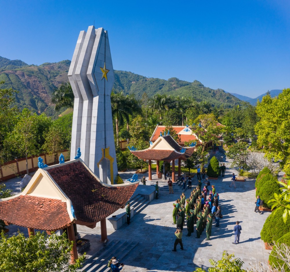
Po Hen historical relic site is the place to record the heroic and heroic fighting moments of our army and people, the battle to protect the sacred sovereignty of the Fatherland. February 17, 1979 has gone down in Vietnam's history as a tragic song about the heroic, indomitable, and steadfast spirit of the people on the ground who did not spare blood and bones, ready to sacrifice to protect national border sovereignty. In that war, 73 soldiers heroically sacrificed their lives to protect the integrity of the country's territorial sovereignty and sacred borders. Typical examples include: Deputy Lieutenant Do Sy Hoa, although injured, he still did not leave the battlefield, fighting until his last breath; Soldier Nong Van Dieu - The person who discovered the enemy earliest and took the lead in fighting the enemy when they first started attacking the station gate; Soldier Hoang Van Tuc stubbornly fought until he ran out of bullets and then went to another point of the unit to fight and sacrifice in a fighting position; Hoang Thi Hong Chiem - The brave daughter of Mong Cai - Hai Ninh commercial worker who heroically sacrificed herself to protect her homeland, protect the borders of the Vietnamese Fatherland... With outstanding achievements in In the struggle to protect the Fatherland, on December 19, 1979, officers and soldiers of Border Guard Station 209 Po Hen were awarded the title of Hero of the People's Armed Forces by the President of the Socialist Republic of Vietnam. After the events of February 1979, Station 209 Po Hen moved to a new location. Po Hen Martyrs Memorial Area, construction began on May 19, 2010, on the occasion of Uncle Ho's 110th birthday and was inaugurated on January 10, 2011; This project is 100% socialized mobilization, invested by the Quang Ninh Province BP Command, with the donation of funds and facilities from groups, units and individuals in all parts of the country. with deep gratitude. The memorial faces North, with a total campus area of 86,304 square meters, including the main construction items: memorial, incense burner, stele house, memorial yard and garden; 16 meters high, built of reinforced concrete, covered with white stone. On both sides are two stele houses, inside there is a stele made of monolithic green stone engraved with the names of 86 martyrs who are border guards of Station 209 Po Hen, commercial staff and Hai Son forestry workers. Every year, on holidays, New Year, anniversaries, traditional days and on the occasion of local political events, activities "Appreciation to fallen heroes" are held here. The Po Hen historical relic site is not only historical evidence of the spirit, determination, and brave and tenacious fighting to protect the sovereignty of every inch of sacred land at the borders of the Fatherland and of the country. collective of officers and soldiers of Border Guard Station 209 Po Hen, of the collective of officers and employees of Lam Truong and the people here. This is also a red address to educate patriotic traditions at the border. The relic is ranked at the provincial level according to Decision No. 178/QD-UBND dated January 23, 2014 and ranked at the National level according to Decision No. 2288/QD-BVHTTDL dated September 20, 2022 and assigned to the Border Guard Station. Directly managed by Po Hen. Source Electronic information portal of Mong Cai city, Quang Ninh province.
Quang Ninh 1301 view
Xa Tac Temple is located in a special location, next to the bank of Ka Long River (Vietnam - China border), in area 3 of Ka Long ward, Mong Cai city. In 2005, Xa Tac temple relic was recognized as a Provincial relic - according to decision No. 2332/QD-UBND of Quang Ninh province dated July 18, 2005. According to the Monument Classification File, the Temple was built around the late 13th and early 14th centuries during the Tran Dynasty to worship the god Xa Tac - the Tutelary God of the ancient Mong Cai continent. Here, we worship Xa Tac Dai Vuong, Hung Nhuong Dai Vuong Tran Quoc Tang, Cao Son Dai Vuong, the Dragon Earth God of the village and the pioneers of the families who have contributed to exploiting this land. In 2005, the temple was ranked by the People's Committee of Quang Ninh province as a provincial historical-cultural relic. According to the elders living around this area, in the past, Xa Tac Temple was built at the edge of the Thac Mang River on a fairly large scale including three houses, facing south, with yin and yang tiled roofs. In the early twentieth century, during a big storm, the Temple collapsed and people moved into the Vortex area on a smaller scale than before. Through the ups and downs of time, up to now, the temple has been restored many times, the biggest restoration was in the year of the Cat 1879. During the Northern border war in 1979, the temple was destroyed, only A few steles and old foundations remain. After 1989, the temple was restored on a small scale. To meet the wishes of the people who want a spacious and large worship facility, in 2009, Xa Tac Temple was decided by the People's Committee of Quang Ninh province to allow restoration and hand over to the People's Committee of Mong city. The investor of phase I and BTS is the Quang Ninh province Buddhist Sangha as the investor of phase II, implementing the project with socialized capital. Today's Xa Tac Temple is built in the south direction, on a high, airy plot of land with a campus area of about 20,000 m2, the east borders the Ka Long river, the remaining three sides border the leased land area of the joint company. Hong Van hotel business. The main temple has an area of 308 m2, built in the style of the letter "cong". In which: the front hall consists of three rooms, two wings, two common rooms and three back rooms. The temple is built mainly of ironwood, the roof is tiled with dragon scales, and the walls are brick. The temple is built with two floors and eight roofs with traditional, sophisticated carved patterns, and the roof is covered with funny-nosed tiles. Currently, Xa Tac Temple still retains three ancient steles dating back to 1879, on which are recorded the names of those who contributed money and contributions to restore and rebuild the temple. Xa Tac Temple is a large-scale historical and cultural relic with a long history. This used to be a place for sacred religious and spiritual activities of residents of Mong Cai and surrounding areas, in addition to the full moon and first lunar month worship days. Every year, five main holidays take place at the temple: January 16, May 2, August 16, December 16, December 18 (AL). During these days, people in the area are divided into 5 groups. During a year, each group is assigned to take care of one main ceremony. January 16 is a day of praying for peace. The Ministry of Culture, Sports and Tourism has just issued Decision No. 3238/QD-BVHTTDL dated November 4, 2020 on the National Relic ranking of Xa Tac Temple Historical Relic (Ka Long Ward, City). Mong Cai, Quang Ninh province). Source Electronic information portal of Mong Cai city, Quang Ninh province.
Quang Ninh 987 view
Nam Tho Pagoda (also known as Van Linh Khanh Tu), located in Nam Tho area, Tra Co ward, is one of the typical valuable relics of Mong Cai city, ranked as a relic by the Ministry of Culture and Information. National level art achievement in 1999. According to the inscription on the recast bronze bell, the pagoda dates back to the 3rd Thieu Tri (1843), in the 15th year of Canh Thinh's reign of King Le Hien Tong (1754). Nam Tho Pagoda was built facing north, with a Muslim-style structure meaning the convergence of water streams. That is also the explanation for the pagoda's name: Van Linh Khanh (Sacred, good). Nam Tho Pagoda includes the main buildings: Three Entrances, Ancestor House, Mother House, Guest House; It has been restored many times, the mark of the Le Dynasty is no longer there. But here a system of 53 ancient statues is still preserved. Most notable are the 4 statues of newborn Sakyamuni, 2 statues of Quan Am Tong Tu and 2 small statues of the Three Worlds bearing the cultural identity of the Vietnamese people. That is why this place is a miniature "ancient sculpture museum" of the Northeast region of Vietnam. Another special feature of Nam Tho Pagoda that few relics have is the ancient forest behind the pagoda. Not only is it a place for cultural and religious activities of local people, Nam Tho Pagoda is also a historical and cultural relic associated with the process of our people's struggle to protect the homeland and build the country. . In 1905, Phan Boi Chau was on his way to China to meet with Japanese revolutionaries. China asked them to support the Dong Du movement. Once while being chased by the enemy, he took refuge at Nam Tho pagoda and was sheltered and helped by the people. During the two resistance wars against the French colonialists and the American Empire, the pagoda was a place to store food, hide grassroots cadres, hide revolutionary documents, and was a place to send off thousands of local children on their journey. join the resistance. In 2014, the People's Committee of Quang Ninh province signed a decision approving the project to renovate, restore and restore Nam Tho pagoda relics with a total socialized investment capital of over 12 billion VND. Located in an important position at the beginning of the country, Nam Tho Pagoda as well as other artistic and cultural architectural works of Mong Cai city are a solid "landmark" affirming national territorial sovereignty, overcoming marking history and imbuing the typical cultural features of the Vietnamese people in the border areas of the Fatherland. Source Electronic information portal of Mong Cai city, Quang Ninh province.
Quang Ninh 1068 view
The mine's revolutionary historical relics include 03 points: + First location: Place where the first Party Cell was established at the mine (Democratic Area) + Second location: Mechanical workshop - Mao Khe mine, where members of the revolutionary youth association Hoi - led by Comrade Hoang Quoc Viet (ie Hang Ba Cang), conducted the proletarianization - This is the policy of propagandizing, training and spreading Marxist-Leninist ideology to the working class in the mining area, creating conditions for the formation of higher organizations of Mao Khe mine workers in the future. + Third address: Non Dong Pagoda: Was a secret base of the Indochina communist organization in the years 1929 - 1930. The 3 locations of the Mao Khe Coal Mine Historical Relic are places that mark the activities of patriotic scholar Nguyen Van Cu and are also where the first Party Cell was established in the Quang Ninh Mine Area. Among them, Non Dong pagoda is recorded in history books from the year Trung Hung 1285; The mechanical factory operated during the French colonial period. Over time, these locations have been damaged and are only ruins. In 2015, from many capital sources, Quang Ninh province started a project to restore and embellish the historic Mao Khe coal mine. Currently, Mao Khe Coal Mine historical relic is one of 14 tourist destinations in Dong Trieu town. The Ministry of Culture, Sports and Tourism has just issued Decision No. 3013/QD-BVHTTDL dated August 30, 2019 on classifying the Mao Khe Coal Mine Historical Relic (Mao Khe Ward, Dong Trieu Town) as a national monument. ). Source Department of Culture and Sports of Quang Ninh province.
Quang Ninh 1372 view
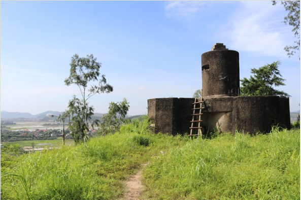
Cao Dong Trieu Fort is located on a hill with an altitude of 61m, with a total area of over 145,000 m2. This is a base built by the French colonialists to house the command center of the French colonial regime for Dong Trieu in particular during the period of French colonial rule. Along with Ho Lao Communal House and Bac Ma Pagoda, Don Cao is one of the places associated with the formation and birth of Tran Hung Dao War Zone - Dong Trieu War Zone. National historical relic Cao Dong Trieu Fort is located on a hill with an altitude of 61m, with a total area of over 145,000 m2. This is a base built by the French colonialists to house the command center of the French colonial regime for Dong Trieu in particular during the period of French colonial rule. This place has also entered the history of the Party Committee, government and people of Dong Trieu town's ethnic groups. Cao Dong Trieu Fort relic is the highest position in the center of Dong Trieu ward. Fort Cao is located on the main traffic route from Chi Linh, Hai Duong to Uong Bi Quang Ninh, from Kinh Mon, Hai Duong via Trieu ferry to Dong Trieu. From Dong Trieu Cao Station, it is possible to remotely observe and detect targets from the North to the South and from the East to the West of the town. Therefore, after invading Vietnam, in 1896 the French colonialists organized the construction of a military camp here to serve the war of invasion and exploit mineral resources in Dong Trieu. In 1945, our people seized power, Cao Dong Trieu station came under the management of the revolutionary government. On the morning of June 8, 1945, Cao Dong Trieu Fort was captured by the Fourth War Zone insurgents under the command of Lieutenant General Nguyen Binh, opening the August revolutionary climax in the entire region. The insurgents started from Bac Ma Pagoda, after capturing Cao Dong Trieu Fort, gathered at Ho Lao communal house. Here, on behalf of the Central Committee, Lieutenant General Nguyen Binh announced the establishment of the Tran Hung Dao resistance war zone, also known as the Fourth War Zone. In 1947, the French colonialists continuously launched major battles to retake Dong Trieu. This time, wherever they occupy, they immediately build and reinforce a system of watchtower posts and towers, aiming for long-term occupation and controlling our forces to fight back from afar. By May 7, 1954, the Dien Bien Phu campaign was completely victorious and Don Cao was under our control. Over a long period of time, many of the buildings belonging to the Dong Trieu Cao Fort relic site have been destroyed, leaving only a part of the buildings remaining such as the Ba mandarin's house, the green loincloth soldier's house and the house solitary confinement and torture of Communist prisoners, artillery barrages, blockhouse systems, underground bunkers... The vestiges here are still important evidence marking an unforgettable historical period of the entire nation in general, of Party committee and people of Dong Trieu in particular. On May 24, 2017, Don Cao relic was decided to rank as a national historical relic by the Ministry of Culture, Sports and Tourism. In the future, Don Cao will be repaired and restored. Source Quang Ninh province electronic information portal.
Quang Ninh 1178 view
The temple worshiping female general Le Chan (An Bien temple) is located on the slopes of Ven mountain in ancient Ven village, An Bien village, Thuy An commune, Dong Trieu town. This is where female general Le Chan was born and grew up during her childhood years with her parents. When she passed away, the people remembered her great contributions and built a temple right in her homeland to worship Mrs. Le Chan, a beautiful and talented female general who led the people to stand up and fight the enemy during the resistance. fight against Northern domination under the Trung Sisters. From a brave general fighting the enemy, female general Le Chan became a Holy Mother in the sense of folk beliefs, a special cultural phenomenon. When Le Chan passed away, her temples were established in many places in provinces such as Quang Ninh, Ha Nam, Hai Phong, Hanoi... In 2006, An Bien temple was ranked as a provincial-level historical and cultural relic. In 2017, it was ranked as a National Historical Monument. In 2018, on the occasion of the victory anniversary of Female General Le Chan (August 15 of the lunar calendar), Dong Trieu Town held a groundbreaking ceremony and started construction of the main temple. After nearly 3 years of repairing and embellishing the monument, in early 2021, the main temple, ritual gate and spacious temple yard were completed as they are today. The festival takes place for 3 days, from March 16 to 18 every year. Source Quang Ninh province electronic information portal.
Quang Ninh 1039 view
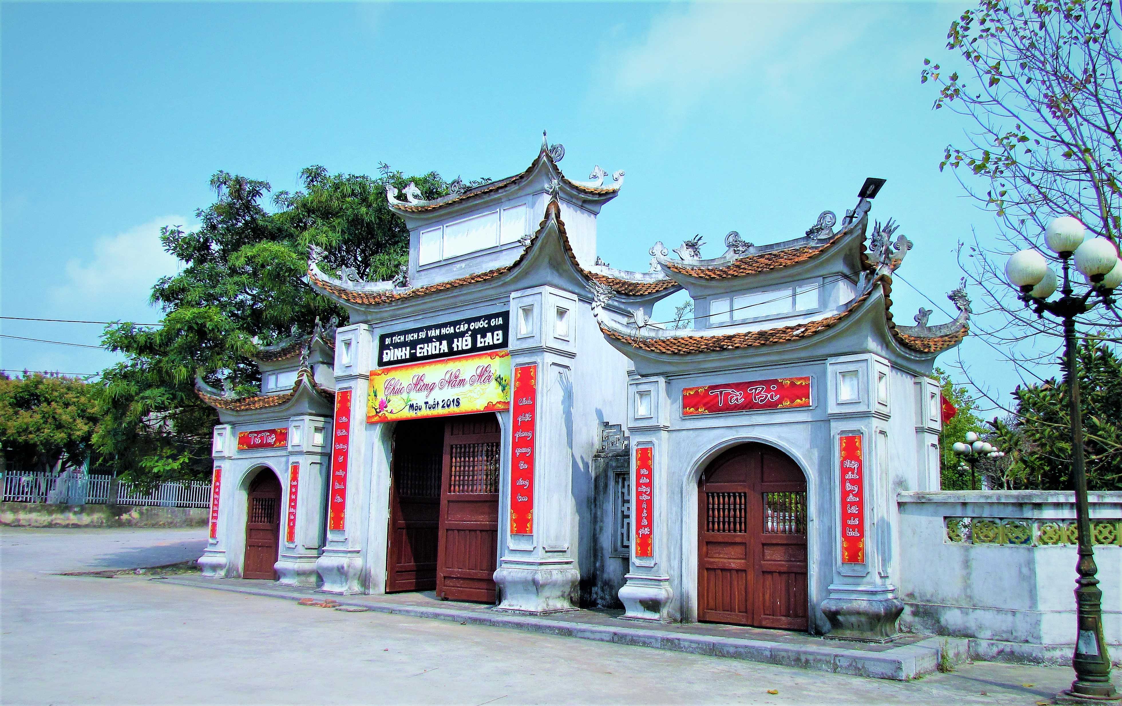
The village communal house - Ho Lao village pagoda was formerly located in Ho Lao commune, Dong Trieu district, Me Son district, Kinh Mon district (now Ho Lao village, Tan Viet commune, Dong Trieu town) and has existed for a long time. The communal house and pagoda are located on a relatively flat mound at the beginning of Ho Lao village. According to feng shui, that mound has the shape of a Tiger, the communal house and pagoda are built on top of this animal in the Southeast direction, in front there are lush green rice fields, in the distance there is the Dam River, behind there is a mountain range. The mountain belongs to the Dong Trieu arc. Truly a spiritual place. According to local elders, in the past, Ho Lao communal house had a Nhi-shaped architecture, the altar had five rooms, two left, the harem had three rooms, two left, the communal house was roofed with Dragon scale tiles, the beams were all made of wood. The pagoda yard is bright, clean and beautiful. The pagoda garden has many ancient trees that are green all year round, creating a peaceful and ancient look. Through many ups and downs in history, natural disasters and invaders, the communal house and pagoda of Ho Lao village were ruined, the stele was destroyed, and during the Nguyen dynasty it was restored. Currently, there are six stone steles built in the following years: Tu Duc's 17th year (1864), Thanh Thai's 16th year (1904), Bao Dai's 1st year (1926), Bao Dai's 7th year (1932), Bao Dai's 14th year. (1939) and the year of Bao Dai Nguyen. Based on the inscriptions, in 1864, the village chief, Nguyen Van Nang, and his wife, Nguyen Thi Tham, gave money to the people to repair the communal house and donated 18 acres of rice fields to the village for rotational cultivation to spend on death anniversary offerings. sacrifice. During Thanh Thai's reign (1889 - 1907), due to fire and fighting, the village communal house was again ruined, the people were scattered, and the land was abandoned. During the reign of King Duy Tan, there was a village chief, Mac Van Cuu, who wholeheartedly cared for the people, and together with Thai Trong Luong, the village leader, held a meeting with the villagers to discuss repairing the communal house. With the help of money from the white clay contractor, the villagers were able to build more pagodas and sculpt the Nine Dragon Saint Statue to worship in the pagoda. Chief Mac Van Cuu is a person who is wholeheartedly devoted to the villagers. He has spent many years working hard and suffering "finding land to recruit people, reclaiming the land, the people are peaceful, customs are good, people's meetings are established, everything is new; Don't hesitate to donate your wealth, and shape our people from that time on" (stela of Tu Duc period). From then until after the August Revolution of 1945, Ho Lao village communal houses and pagodas became the cultural centers of the village and commune. When the Viet Minh movement in Dong Trieu flourished, this place became an operating base for the revolutionary army, and many important political events took place here. On the afternoon of April 20, 1945, the first armed propaganda team of the Viet Minh Front in Dong Trieu was established. On the morning of May 1, 1945, the team held an launching ceremony in front of the Earth God Temple at Mr. Mac Van Niet's house in Ho village. TB. The team was raised by the people of Ho Lao village. Mr. Mac Van Niet and Mac Van Que were in charge of logistics for the team. In mid-May 1945, the centralized armed forces of Dong Trieu district were established and regularly practiced at Ho Lao communal house, held propaganda meetings, and conveyed instructions and resolutions of superiors. This young armed force has grown rapidly to become a solid support for the people, creating favorable conditions for the armed forces and the people to simultaneously rebel and capture 4 posts: Dong Trieu, Chi Linh, Mao. Khe, Trang Bach on June 8, 1945 and won a resounding victory. On the afternoon of June 8, 1945, in the atmosphere of the insurgents celebrating their victory at Ho Lao communal house, the uprising's leadership met and decided to establish the Revolutionary Military Committee consisting of comrades Nguyen Binh, Hai Thanh, Tran Cung and a number of other members headed by Nguyen Binh. On the morning of June 9, 1945, during a rally at the communal house of Ho Lao village, Tran Cung, on behalf of the uprising leadership, announced the establishment of a revolutionary war zone named FOURTH WAR ZONE, the armed forces of the war zone named "GUERARIAN REVOLUTIONARY ARMY", announced the list of UBQSCM. Nguyen Binh, representative of the Committee of the People's Liberation Army, announced the "seven rules of discipline of the revolutionary guerrilla army". Ho Lao has become the center of the military base of the war zone. From here, Nguyen Binh and the war zone leadership commanded units to expand their scope of operations and won many resounding victories in Uong Bi, Quang Yen, and the Northeast region of the country. The Fourth War Zone (Dong Trieu war zone - Tran Hung Dao war zone)) became a heroic anti-Japanese base in the pre-uprising period, encouraging the people of the Northeast to stand up against the Japanese, along with the whole country. leading to the victory of the General Uprising on August 19, 1945. In 1947, the French colonialists returned to occupy Dong Trieu and tried to destroy revolutionary bases, including Ho Lao village. The communal house and pagoda of Ho Lao village were also destroyed and became ruins. In 1993, the people of the village contributed money to rebuild the old temple's harem as a place for religious activities. In 1997, on the foundation of the old communal house, Tan Viet commune built a memorial stele where the FOURTH WAR ZONE was founded and recognized the children of the homeland who heroically sacrificed their lives in the two resistance wars against the French, the Americans and the Americans. protect the Fatherland's borders. Due to his many contributions to building, nurturing and protecting the revolutionary army, the people of Ho Lao village were awarded the certificate of Meritorious Service to the Country by the state. On July 12, 2001, the Ministry of Culture and Information issued a decision to recognize Ho Lao Communal House - Pagoda as a National Historical and Cultural Monument. On December 12, 2007, the Ministry of Culture, Sports and Tourism and related sectors of the province, district and locality held a groundbreaking ceremony to restore the communal house and Ho Lao pagoda and build a number of suitable works. support with a total estimated cost of nearly 16 billion VND. Buddhists and visitors from everywhere earned over 2 billion VND. The contributions of the people of Ho Lao village in particular and the people of Tan Viet commune in general have contributed to the victory of the people of Dong Trieu and were awarded the noble title "Heroic District of the People's Armed Forces" by the state. ”On May 28, 2010, the state awarded the title "Hero of the People's Armed Forces" to the people and armed forces of Tan Viet commune for their exceptionally outstanding achievements in the resistance war against the French. . Now, along with the anniversary of June 8 - the founding day of the Dong Trieu War Zone, every year the people of Tan Viet commune also have another big festival: Ho Lao communal house and pagoda festival held on the first day of new spring ( January 15). Located adjacent to Sinh Temple and Tran Dynasty tombs (special national relics) and with National Historical-Cultural values... communal houses, Ho Lao Pagoda will be an attractive tourist destination contributing to educating patriotic traditions and fighting foreign invaders; Economic, cultural, social and tourism development of the locality and Dong Trieu town. Source Electronic information portal of Dong Trieu town, Quang Ninh province.
Quang Ninh 1277 view
My Cu Pagoda, the literal name is Sung Khanh Tu. The pagoda was built in My Cu village, so the pagoda was named after the village. The name of the village comes from the legend: "Legend has it that King Tran Nhan Tong went to Yen Tu mountain to become a monk. People made delicious food for the king, so he named it My Cu" and the name Sung Khanh Tu has the meaning of promoting Buddhism. boundless, khanh means good. My Cu Pagoda is located on the side of Che Mountain (a turtle-shaped mountain), in My Cu village, Hung Dao ward, Dong Trieu town, Quang Ninh province. During the Tran Dynasty, Buddhism entered the most brilliant period of development in Vietnamese history and affected all areas of life. After King Tran Nhan Tong became a monk in Yen Tu and founded the Truc Lam Zen sect, Phap Loa, under the guidance of King Tran Nhan Tong, received the Dharma medicine and became the second patriarch of the Truc Lam Zen sect. . During Phap Loa's reign, Truc Lam's teachings had a strong appeal to Buddhist followers. From Yen Tu, Truc Lam teachings spread throughout the Northeast region. During this period, 800 large and small temples were built. My Cu Pagoda was also built during this period. The pagoda was built with the scale and architectural structure of the letter Ding. In later times, the pagoda was expanded quite spaciously, including the main pagoda, the ancestor's house, and the monk's house, forming an overall mouth-shaped architecture. The pagoda has undergone many restorations and embellishments, which are recorded in stele placed in the pagoda yard. But at the end of the Nguyen Dynasty, the pagoda was destroyed, leaving only the main pagoda with a nail-shaped (T)-style architecture with truss structure and sculpture that still retains its original state and a system of dharma statues with high artistic value. , such as statues: Amitabha, Shakyamuni statue, Quan Am Chuan De statue, Ca Diep statue, Anan statue... Wooden statues with related ages from the Tay Son and Nguyen dynasties are still preserved quite well. The statue system is meticulously and skillfully carved, each statue has a different shape and inner expression. The carvings are soft but strong and decisive. The colors and decorative patterns on each statue are imbued with national cultural identity. Besides, My Cu Pagoda also has carvings on the rafters, ends, lines, sevens... demonstrating the ingenuity and sophistication of the craftsmen who have the heart to create and restore the Buddha's place. Electronic information portal of Dong Trieu Town, Quang Ninh province.
Quang Ninh 1148 view
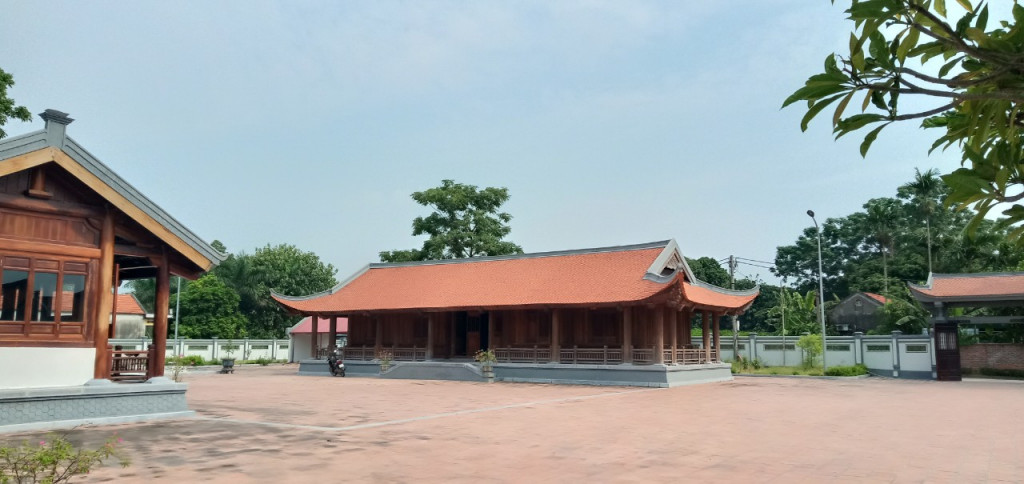
The center of this base is located at Bac Ma Pagoda, also known as Phuc Chi Tu, meaning pagoda towards happiness. Dong Trieu War Zone is the name given to the place, where the main base is located in Dong Trieu district, Quang Ninh province. Dong Trieu war zone is also known as Tran Hung Dao war zone (this is the naming of the Party Central Committee). Revolutionary historical and cultural relics of Dong Trieu war zone were the base of revolutionary leadership in the resistance war against French colonialism. The center of this base is located at Bac Ma Pagoda, also known as Phuc Chi Tu, meaning pagoda towards happiness. Dong Trieu War Zone is the name given to the place, where the main base is located in Dong Trieu district, Quang Ninh province. Dong Trieu war zone is also known as Tran Hung Dao war zone (this is the naming of the Party Central Committee). To further promote the preparation of armed uprising throughout the country, right from April 15, 1945, the Party Central Committee's Standing Committee convened a revolutionary military conference in Hiep Hoa (Bac Giang). decided to establish seven war zones throughout the country: Le Loi war zone, Hoang Hoa Tham war zone, Quang Trung war zone, Tran Hung Dao war zone, Phan Dinh Phung war zone, Trung Trac war zone, Nguyen war zone Tri Phuong. Implementing the decision of the Northern Military Conference, the Northern Party Committee has proposed the policy of building the Tran Hung Dao war zone in the Northeast region. During the preparation process for the uprising, the pagodas in Dong Trieu played a quite important role, Bac Ma Pagoda was the pagoda that played the most role in forming the base of the Tran Hung Dao war zone, where Master Vo Giac Thuyen regularly welcomed revolutionary monks, who were revolutionary cadres bearing the name of monks to facilitate their activities (before August 1945, Bac Ma Pagoda was a large, prestigious pagoda in the region and located In places with revolutionary traditions, these are favorable conditions for building bases). Bac Ma Pagoda is a large-scale architectural space built on a campus with an area of up to three acres of land. According to the preserved epitaphs and Chinese writings, the history of Bac Ma pagoda is over six hundred years and has been restored and embellished many times during the Le and Nguyen dynasties. Especially in the year of Bao Dai Nguyen, 1926, the pagoda was rebuilt on a larger scale, becoming a large, beautiful, and sacred pagoda. The pagoda's land has up to 20 acres with three plowing buffaloes and two helpers. Up to now, Bac Ma pagoda is no longer intact as before, the architectural frame structure has been completely ruined but some artifacts are still retained. The art of stone carving at Bac Ma Pagoda is expressed quite sophisticatedly in the remaining artifacts (steles, dragons, towers...) It skillfully combines the art of the Tran and Late Le periods. , Nguyen. The stone carving shows the sculpture of the Tran Dynasty through the dragon statue placed on the stairs, remaining. The dragon's layout is compact, the lines are very vivid and strong, the body is round, plump, gradually chubby towards the back of the tail, with slight curves. Stone sculpture of the Later Le period is clearly shown in the stone steles with the image of two dragons flanking the monstrance, coherent carvings, and soft flowers and leaves on both sides along the stele's body, stylized to represent the sculpture of the time. Pear The historical site of the center of the Dong Trieu war zone has been ranked as a National Historical Relic by the Ministry of Culture and Information according to Decision No. 2379/QD-BT, dated September 5, 1994. Source Quang Ninh province electronic information portal.
Quang Ninh 1125 view
Lang Le Bau Co relic site is located in Tan Nhut commune, Binh Chanh district, Ho Chi Minh City. Lang Le Bau Co is associated with the resistance war against the French invasion in 1948 with major battles that went down in history. Lang Le Bau Co relic was recognized as a city-level historical relic in 2003. The reason it is called Lang Le Bau Co relic area is because the name of Lang Le Bau Co relic area was given by local people. The hamlet was established next to the interlaced canals and rivers. Lang Le Bau Co is located inside a large field with many shrimp, crabs, and fish. Along with many species of birds such as mallards, storks, teal, nuthatches, gongs, partridges, herons, and red armpits come to feed here. Therefore, Tan Nhut people call it by the familiar and rustic name Lang Le Bau Co. Lang Le Bau Co relic is considered the gateway to move to the center of Vuon Thom base and attack the enemy headquarters in Saigon. Previously, Lang Le Bau Co relic area was originally a field of overgrown reeds. On April 15, 1948, the French colonialists sent 3 thousand soldiers and many modern weapons to simultaneously attack the Lang Le Bau Co area to destroy the Vuon Thom base. At that time, the revolutionary armed forces in Lang Le - Bau, because of their small force and rudimentary weapons, had the help of local people along with the advantage of terrain. After just over half a day of fighting, it turned to attack, causing the French army to suffer a large number of casualties. The victory at Lang Le Bau Co killed 300 enemies, captured 30 mercenaries, and destroyed many machines, military vehicles, and guns of all kinds of the enemy. However, on our side, there are many officers and soldiers who heroically sacrificed their lives at a very young age. On October 14, 1966, in Lang Le, the Republic of Vietnam Army Ranger Battalion was destroyed by tourist militia. Lang Le Bau Co relic site has great historical significance for the people of Saigon in particular and the whole country in general. Faced with hatred for the French colonialists, Lang Le Bau Co's army and people fought a war of great historical significance that opened the door for our side and the enemy. For our side, the battle opened the door to heroism in a strong resistance position. As for the enemy, they had to retreat into a strategic position and were destroyed. The French colonialists could no longer form a strategy to defeat the Viet Minh. Moreover, at Vuon Thom base, Lang Le Bau Co also took place a determined battle to protect our base and destroy all sabotage plans of the enemy. Lang Le Bau Co relic area, after the Dong Khoi movement in 1960, was also a logistics and springboard for the armed forces to liberate Long An - Saigon - Gia Dinh. To commemorate the sacrifices of our compatriots and soldiers, in 1988 Binh Chanh district built a historical building in Lang Le Bau Co land with an area of 1000m2. Source: Ho Chi Minh City Electronic Information Newspaper
Ho Chi Minh City 6795 view
Tan Hiep Prison, also known as "Tan Hiep Correctional Center", is located in Quarter 6, Tan Tien Ward, Bien Hoa City. Tan Hiep Prison Relic was ranked as a national relic by the Ministry of Culture and Sports on January 15, 1994. Tan Hiep Prison is one of the six largest prisons in South Vietnam and the largest prison in the Southeast region, built in an important military position, northeast of Bien Hoa town. Ahead is National Highway 1; Behind is the North - South railway line. This is an isolated location, convenient for transportation, easy for protecting, guarding, receiving prisoners from other places and transferring prisoners to Con Dao, Phu Quoc... Tan Hiep Prison has an area of 46,520 square meters with 8 prisons, including 5 prisons for communist prisoners and patriots. The prison is surrounded by 4 layers of barbed wire with 9 bunkers, 3 watchtowers with a team of guards and a modern alarm system. It's called "Correctional Center" but inside is actually a gun warehouse, an interrogation and torture room with the most modern tools. Each prison only has an area of nearly 200 square meters but holds 300-400 people, sometimes up to a thousand people. In particular, there are "repentance" rooms and "tiger cages" that are very small and narrow and living conditions are extremely harsh, prisoners live like in a crematorium. The diet was extremely unhygienic. The prison guards bought rotten rice and rotten fish to fertilize the fields, and fried them in oil to feed the prisoners, leading to many people being poisoned. With the determination to escape the imperial prison, return to the Party and the people to continue fighting and liberating the nation, on December 2, 1956, with the agreement of the Eastern Inter-Provincial Party Committee, the soldiers Communists were "detained" in Tan Hiep prison under the direct direction of comrade Nguyen Trong Tam (Bat Tam) - in charge of the prison Party Committee and a number of other comrades who suddenly broke the shackles. was able to free nearly 500 comrades and patriots. This event caused a stir in the Pentagon. America - Diem hastily mobilized both main forces and security forces, civil guards defending the three provinces of Bien Hoa, Ba Ria, Thu Dau Mot and two special forces to encircle and capture the prisoners, but all were defeated. failure. Our comrades and compatriots who escaped from Tan Hiep prison received help and protection from local facilities and returned safely to base. Among the escaped prisoners were comrades: Bay Tam, Hai Thong, Ly Van Sam... who became the core nucleus of the Dong Khoi movement later. In 2001, to partly recreate the crimes of the US - Diem against our comrades and compatriots imprisoned at Tan Hiep prison and describe the entire Tan Hiep uprising on December 2, 1956. , Dong Nai Museum has collected images, documents, and artifacts displayed at the relic and made a model to serve the research and sightseeing needs of all classes of people. Every day, the monument is open to visitors. Source: Dong Nai Electronic Newspaper
Dong Nai 6161 view
La Nga Victory Relic (at km 104-112 on Highway 20 to Da Lat, in Phu Ngoc commune, Dinh Quan district) was ranked a national historical relic by the Ministry of Culture on December 12, 1986. To cheer for the Viet Bac victory in the fall-winter of 1947 and also to deal a fatal blow to the enemy, the command board of squad 10 decided to organize a big battle, to show the enemy that the Vietnamese people were , Vietnamese people do not easily submit to any enemy; With a spirit of courage and ingenuity after nearly half a year of preparation, studying the terrain, and choosing a location: at 15:12 on March 1, 1948, the La Nga ambush battle began and ended at 15:12 on March 1, 1948. 15:57 on the same day, in just 45 minutes. The victory of La Nga delighted the people of Dinh Quan in particular and the people of Dong Nai in general. This is a victory that demonstrates the cunning and courage of our army and people, causing the enemy to be stunned and defeated. From this victory, our force grew stronger and stronger, contributing to defeating the enemy's plan to attack quickly and win quickly, forcing them into a passive position. The scenic complex of Chong Rock, Mai Waterfall, La Nga River and La Nga Victory Monument is an interesting tourist complex of Dinh Quan. The amazing beauty of Hon Ba Chong, Da Voi Mountain, Hon Dia, along with the natural pagoda at the foot of the rocky mountain are typical clusters that create a harmonious beauty for the Da Chong scenic area. Dinh Quan Da Chong Complex is also a place that retains traces of prehistoric life. Here, under the stone roofs, along the streams and on the slopes along the valley, many production and daily life tools of the ancients made of stone, bronze and terracotta were discovered. During the 30-year resistance war. Dinh Quan is an important part of War Zone D. Da Chong witnessed the formation, development, stationing, and combat deployment of revolutionary forces. Today, a part of the land of Da Chong Dinh Quan scenic area has been used and built into the Dinh Quan District Cultural and Sports Center. In the near future, Da Chong Dinh Quan scenic area will be invested in and renovated, contributing to making the natural landscape more beautiful and becoming an attractive eco-tourism destination. Source: Dinh Quan District People's Committee
Dong Nai 4157 view
The US Embassy relics, also known as the "White House of the East", are the origin of sinister military and political plots aimed at long-term annexation of Vietnam. The relic site is a 5-storey building built Built in modern architecture, located at the corner of Mac Dinh Chi - Le Duan Street, Ben Nghe Ward, District 1, Ho Chi Minh City, on a plot of land nearly 5,000 square meters. Previously, the US embassy was located at 39 Ham Nghi Street. At around 10:00 a.m. on March 30, 1963, the US embassy on Ham Nghi Street was hit with explosives by the F21 Commando team, collapsing three floors: 1, 2, 3, so the US decided to rebuild it. Construction began on the building in 1965, most of the materials and construction machinery were transported from the US, under the control of American engineers. According to the design, the building is surrounded by 7,800 Taredo stones that can withstand mines and artillery shells. The main door is equipped with thick steel, the other doors are blocked by a special thick bulletproof layer. All doors use automatic systems, including iron doors blocking the way to the upper floors. Inside the building there are 140 rooms with 200 staff serving day and night. In addition, next to the building is also built an additional row of houses called the "Norodom" area exclusively for C.I.A. employees. When inaugurated, the building had only 3 floors. At the end of 1966, two more floors and a terrace were built to serve as a landing place for helicopters. Surrounding the building is a 3m high wall, at both ends of the wall close to Le Duan Street, 2 high blockhouses are built, guarded day and night. The Embassy was completed in September 1967 with a defense system such as a fortress with 60 guards, a bomb shelter, and a radar screen system to control the facade. Immediately after the building was completed, on September 24, 1967, thousands of students flocked to the gate of the US Embassy to fight for "America to stop bombing the North", "America to go home" and issued a notice denouncing the US for "trampling and seriously violating the right to self-determination of the Southern people". But the outstanding event that happened at the US Embassy was the battle of the City Rangers during the General Offensive and Uprising in the Spring of 1968. The target of attacking the US Embassy was added on January 24, 1968 by Ngo Thanh. Van is in charge of general affairs. Ranger Team 11 took on this important mission, including captain Ut Nho (military region reconnaissance captain) and soldiers: Bay Truyen, Tuoc, Thanh, Chuc, Tran The Ninh, Chinh, Tai, Van, Duc, Cao Hoai Vinh, Mang, Sau and 2 drivers: Tran Si Hung and Ngo Van Thuan. Another equally humiliating event for the US Embassy was the chaotic escape that occurred on April 29 and 30, 1975 by the US and its accomplices. Faced with the rapid attack of the Vietnamese army and people in the historic Ho Chi Minh campaign, over 1,000 Americans and more than 5,000 pro-American Vietnamese jostled, pushed, and kicked each other to compete for a place on the terrace of the building. building to be rescued by helicopter. This relic was granted a certificate of recognition by the Ministry of Culture on June 25, 1976. Currently, the US Embassy building has been demolished and a new consulate in Ho Chi Minh City has been built, but next to it is a memorial stele forever remembering the achievements of the special forces soldiers who died in the battle. . Source: Ho Chi Minh City Youth Union
Ho Chi Minh City 4117 view
Nguyen Huu Canh temple, also known as Binh Kinh communal house, is located on the left bank of Dong Nai river, formerly belonging to Binh Kinh hamlet, Binh Hoanh village, Tran Bien canton, now Nhi Hoa hamlet, Hiep Hoa commune, Bien Hoa city. It was ranked as a national historical relic by the Ministry of Culture, Information, Sports and Tourism on March 25, 1991. Nguyen Huu Canh Temple was built around the end of the 18th century. Initially, the temple was small in scale, with walls made of boards and a yin-yang tile roof, about 400m south of the current temple. Documents say: the temple was first rebuilt in the fourth year of Tu Duc (1851); By 1923, the temple was rebuilt at its current location. Nguyen Huu Canh was born in 1650 in Gia Mieu, Tong Son district, Thanh Hoa province in a family with many famous generals in the dynasty. He was a man of both literature and martial arts, accomplished many great victories and was trusted, loved and respected by Lord Nguyen. In the spring of the year Mau Dan (1698), he obeyed Lord Nguyen's order to invade Dang Trong while it was still very desolate. Arriving in Dong Nai, he set up his headquarters at Cu Lao Pho (now Hiep Hoa commune); took Dong Nai land as Phuoc Long district, built Tran Bien palace, took Saigon land as Tan Binh district, built Phien Tran palace, the land expanded thousands of miles. He recruited immigrants to settle down, organized the administrative apparatus gradually and systematically, encouraged land reclamation, and promoted Cu Lao Pho to develop into one of the busiest and most dynamic port towns throughout the century. 18 and officially annexed the new land of the South into the Dai Viet map. After returning from the invasion of the South, the following year he again served Lord Nguyen Phuc Chu's command to lead an army to suppress King Chan Lap and maintain the southern border region. In April of the year Canh Thin (1700), after completing his mission, on the way back to Rach Gam (Tien Giang), he fell ill and passed away on the 16th day of the 5th lunar month, at the age of 51 years old. On the way to his hometown for burial, his coffin was stopped at the land where he once had his headquarters on Cu Lao Pho so that local people could have the opportunity to say goodbye to him one last time. At the mandarin's communal house, local people built a tomb to remember this event. When hearing the news of Nguyen Huu Canh's death, Lord Nguyen was extremely sorry and conferred on him the title of High-ranking official of the Town Chancellor with the title: Thanh Marquis Ceremony and had his tablet enshrined at the Thai temple. Source: Dong Nai Electronic Newspaper
Dong Nai 4048 view

During the period when the Mac dynasty had its capital in Cao Bang, in order to prevent the Le dynasty from attacking, the Mac dynasty restored and repaired Na Lu citadel (now in Hoang Tung commune, Hoa An) and Ban Phu citadel (now in Hung Dao commune). ), Phuc Hoa citadel, in addition to building many other citadels in Cao Bang, making Cao Bang a political and military center in the far Northeast border region at that time. Na Lu citadel and Phuc Hoa citadel are two citadels built before. According to the records of Be Huu Cung in Cao Bang Thuc Luc, Na Lu citadel and Phuc Hoa citadel began in the reign of Tang Y Tong in the year Giap Than, the 5th Ham Thong era (874). Based on the presence of many ancient tombs with stone inscriptions containing the names, addresses, and hometowns of the citadel builders who died here during the Ham Thong Dynasty, it can be confirmed that these two citadels were built during the Tang Dynasty. Na Lu Citadel was built over many different dynasties. When the Mac dynasty came to Cao Bang, it was rebuilt with bricks. Na Lu citadel has a nearly rectangular shape, has a total area of about 37.5 hectares, a length of about 800 m, a width of about 600 m, the citadel has 4 gates. Ban Phu citadel in the capital of Nam Binh, Nam Cuong country of Thuc Phan in the past in Cao Binh (Cao Bang), the Mac dynasty renovated the royal palace in the inner circle of the old capital of Nam Binh and called it Ban Phu citadel or Royal Palace. In the ancient capital of Nam Binh of the Nam Cuong country and the Mac dynasty, Ban Phu citadel still has clear traces. The capital city of Nam Binh consists of two citadels, to protect the citadel, the outer ring has a circumference of about 5 km, including a low hillock area, around the foot of the hill is covered with vertical canvas like a wall, convenient for navigation. Build defense lines. The western wall of the citadel runs parallel to the bank of the Bang River to the beginning of Bo Ma village, connecting the southeast wall of the citadel, flowing in front of Ban Phu, following the foot of the hill to meet National Highway 4, the northeastern side running along the foot of the hill close to the outside of National Highway 4. , up to the top of the mound is the northwest side, continue running along the foot of the hill, out to the river bank and meet the west wall, forming a closed citadel. When the Mac Dynasty established the capital, it repaired and built a number of additional works, in which Ban Phu Citadel (inner citadel - the king's working place) was built higher on the old citadel walls from the Thuc Phan period. The citadel is located on a flat land. Along with rebuilding the capital, the Mac dynasty also built a system of posts and ramparts quite thick around the capital and a number of important border points, forming a system of protecting the capital and protecting the border. gender. Phuc Hoa citadel (Phuc Hoa district) was built in a square style, about 400 m in each direction, including two citadel rings, the distance between the two rings is 80 m. Currently, the southern wall has been completely destroyed. Phuc Hoa Citadel has 2 main gates: The North Gate is open to the national highway to Ta Lung Border Gate today, people often call it Pac Gate, this gate is built in a rectangular style, 8 m wide, 5 m high. , including two gates made of thick, very sturdy wood; The second gate is in the south, opening to the river bank. Both gates were flattened long ago, and now there are no traces left. Near the citadel, in the northwest suburbs along the riverbank, there are many traces of brick kilns. People said that during the process of labor and exploration, many intact brick kilns were found in this area. Through research and surveys, it has been shown that in Cao Bang, the Mac dynasty renovated, embellished and built many citadels and fortresses, including repairing, embellishing and rebuilding Ban Phu citadel, Na Lu citadel, and Phuc citadel. Hoa. These fortifications have formed a quite solid system of protecting the capital. Up to now, of the ancient citadels built by the Mac Dynasty during the capital period in Cao Bang, some of the citadels built of earth only have traces left, but the citadels built of stone are still very clear. Source: Cao Bang Electronic Newspaper
Cao Bang 3811 view
Chot Mat Tower Historical-Cultural Relic, located in Xom Thap hamlet, Tan Phong commune, Tan Bien district, Tay Ninh province, was recognized by the Ministry of Culture and Information (now the Ministry of Culture, Sports and Tourism) as historical - cultural relic on July 23, 1993. Also one of the last three ancient towers remaining in the South of our country. Having undergone many restorations in 1938, 2003 and most recently in 2013. Despite undergoing restorations, the Chot Mat ancient tower relic site has given itself a new look but still remains retains the spirit of ancient architecture. The entire Tower is built of brick and slate with the top of the tower tapering upward, from the ground to the highest point of the tower is estimated to be 10m. In addition, this ancient tower is located on a high mound in the middle of the field, so from a distance it looks like a pen rising gradually. In 2003, the People's Committee of Tay Ninh province decided to approve the investment project to restore, embellish and preserve Chot Mat tower relics and carried out the restoration, restoration, display and opening of the excavation pit in 2003. into use. On November 27, 2019, the Provincial People's Committee issued a Decision regulating the decentralization of management, protection and promotion of the value of historical and cultural relics and scenic spots in Tay Ninh province. Decision to assign the People's Committee of Tan Bien district to directly manage 4 relics, including the National Historical-Cultural relic Thap Chot Mat. In particular, the Chot Mat Tower Historical-Cultural Relic in Tan Phong commune, Tan Bien district was chosen to be part of the tourism development link of Tay Ninh Province. This is a tourist destination worth exploring, contributing to tourism development in Tan Phong commune in particular and Tan Bien district in general. Source: Tay Ninh province electronic information portal
Tay Ninh 3737 view
Bac Cung Temple (literally known as Thinh Temple) in Tam Hong commune, Yen Lac district is one of four large temples around the Ba Vi mountain region and the Red River Delta worshiping Saint Tan Vien. The temples: Tay Cung, Nam Cung, and Dong Cung are on the other side of the Red River in Son Tay territory. These are four temples that were built and preserved relatively carefully by the people. The temple is located in the middle of fertile fields on a 10,000 square meter plot of land next to winding canals, surrounded by rich and densely populated villages. On both sides, the left desert and the right desert stand majestically and silently, covering a large brick yard, looking up to a unique architectural work. Thinh Temple was built 20 centuries ago on the foundation of a small temple worshiping Saint Tan, where he had previously let his troops stay during a mission to help people clear land and manage water. The divine genealogy passes down that: Saint Tan (still called Son Tinh), whose name is Nguyen Tuan, was born on January 15, Dinh Hoi year in Lang Xuong cave, Trung Nghia commune, Thanh Thuy district, Phu Tho province. He lost his father at a young age and lived with his mother and two cousins, Nhuy Hien and Nguyen Sung. Every day, the three brothers crossed the Da River and went to the Ba Vi mountains to clear fields and farm, looking for a living. Here, Nguyen Tuan met Princess Thuong Ngan, was adopted by her, and gave her a walking stick and many magic spells to save humanity. After defeating Thuy Tinh and marrying Princess Ngoc Hoa, he refused the throne that King Hung wanted to give him, and with his two younger siblings traveled everywhere, helping people clear land and water, and was respected by people everywhere. When passing through the Tam Hong area, he let the troops rest and taught the people to grow rice and fish... After he left, the villagers came to the place where the Holy One rested and saw that there were still some packets of hearing left there, so after This temple is called Thinh temple. There is also a story that: when letting the army stay here, Saint Tan taught the people to butcher Thinh, so the people called the temple that name. From a small temple, during the reign of King Ly Than Tong (1072-1128), the temple was rebuilt into a large temple. This is where the king came to pray for longevity. During the reign of King Minh Mang (1820-1840), the temple was repaired many times. During the reign of King Thanh Thai, the Tri of Yen Lac district appointed monk Thanh At to restore the temple. The project lasted until the 6th reign of Khai Dinh (1900-1921). Through many ups and downs, the temple continues to be preserved and preserved by local people. On January 21, 1992, the temple was recognized by the Ministry of Culture and Information as a cultural and historical relic. Every year, the Thinh Temple festival is held from the 6th of the first lunar month to the 20th of the first lunar month. The festival includes sacrifices, palanquin processions from villages inside and outside the commune and many folk games will be held. Source: Vinh Phuc province electronic information portal
Vinh Phuc 3631 view
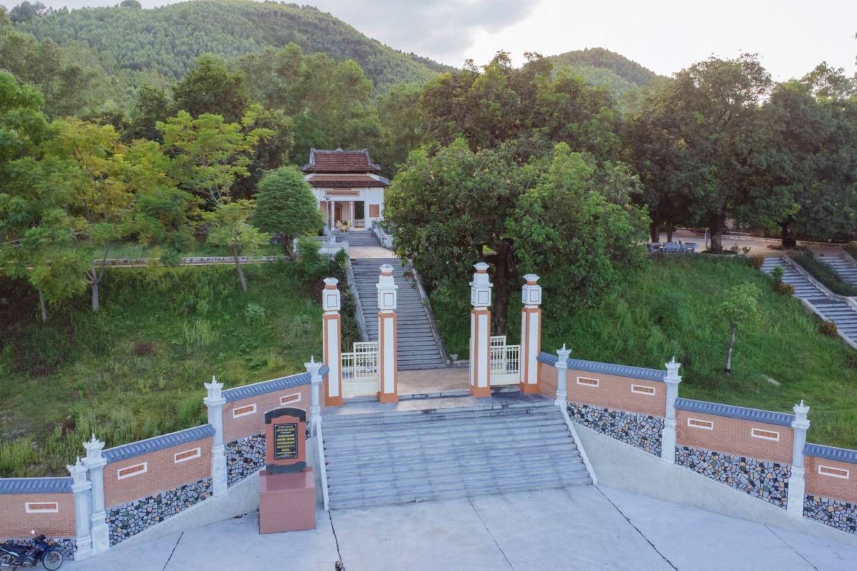
Mai Xuan Thuong was the leader of the Can Vuong movement against the French at the end of the 19th century in Binh Dinh. Mai Xuan Thuong was born in the year of Canh Than, 1860, died in the year of the Pig, 1887, from Phu Lac village, Phu Phong district, Tuy Vien district, Binh Dinh province (now Phu Lac village, Binh Thanh commune, Tay Son district, Binh Dinh province). His father, Mai Xuan Tin, was the chief father in Cao Bang. His mother, Huynh Thi Nguyet, was the daughter of a noble family in the village. Mai Xuan Thuong is inherently intelligent and eager to learn. At the age of 18 (1878), he passed the Baccalaureate at Binh Dinh Examination School. At the age of 25 (1885), he passed the bachelor's exam. Responding to King Ham Nghi's Can Vuong edict, Mai Xuan Thuong returned to his hometown of Phu Lac, recruited insurgents, set up a base on Sung island to raise the Can Vuong flag against the French, then Mai Xuan Thuong brought his forces to join the army. The insurgent army was led by Dao Doan Dich and was appointed by Dao Doan Dich to the position of Military Salary Officer (in charge of food for the insurgent army). From then until 1887, the Can Vuong movement in Binh Dinh developed strongly and spread to Quang Ngai, Phu Yen... attracting tens of thousands of people from all walks of life to participate. On September 20, 1885, Dao Doan Dich died and assigned all his forces to Mai Xuan Thuong. He chose the Loc Dong mountain area (now in Binh Tuong commune, Tay Son district) as his headquarters and organized a flag worshiping ceremony, calling on scholars, literati, and people to join the movement to fight against the French. During that ceremony, insurgents from many regions in Binh Dinh province agreed to honor him as the Marshal leading the uprising and raised the slogan: "First to kill the left, later to attack the West". In early 1887, the French army under the command of Lieutenant Colonel Cherrean and the royal army led by Tran Ba Loc along with Minister Trira launched a major attack on the headquarters of the Can Vuong movement in Binh Dinh, the battle The fighting between the insurgent forces and the French enemy was extremely fierce, the fight was unequal, and in the end the insurgent force was pushed back. In March 1887, after a fierce battle in Bau Sau (An Nhon town, Binh Dinh province), Mai Xuan Thuong was seriously injured, the insurgents withdrew to Linh Dong secret area. On April 21, 1887, Tran Ba Loc surrounded and captured the Linh Dong secret base and captured a number of insurgents, including Mai Nguyen Soai's mother. On the night of April 30, 1887, Mai Xuan Thuong sent a suicide squad to break into Tran Ba Loc barracks, relieve the captured people, and he and a group of 50 subordinates crossed the mountain into Phu Yen and continued to resist. battle, but when she reached Phu Quy Pass (boundary between Binh Dinh and Phu Yen), she was captured by Tran Ba Loc's ambush and taken to be beheaded at Go Cham (East of Binh Dinh Citadel). The mausoleum of patriot Mai Xuan Thuong is located on a high hill of the Ngang mountain range (in Hoa Son village, Binh Tuong commune, Tay Son district, Binh Dinh province) about 50km northwest of Quy Nhon city; The mausoleum was built on a land area of 1988m2, inaugurated on January 22, 1961. Overall, the mausoleum is designed in the style of an ancient mausoleum, surrounded by low walls. The Lang gate (three gates) is made up of 4 square pillars, the top is tied in the style of a gourd and a vase, bearing the architectural appearance of a communal house or temple gate of the late 19th century. In the middle of the Mausoleum is Mai Xuan Thuong's tomb, rectangular in shape in the East - West direction; At the head of the grave is a stone stele engraved with an inscription recording the biography and career of Mai Xuan Thuong: The relic was ranked at the National level by the Ministry of Culture and Information on April 20, 1995. Source: People's Committee of Tay Son District, Binh Dinh Province
Binh Dinh 3546 view
Hoc Mon District Palace is located at No. 1, Ly Nam De Street, Hoc Mon Town, (next to the District People's Committee headquarters) and is the place where many outstanding fighting events have been recorded throughout the long history from 1885 to the Southern days. Complete liberation of the People of 18 Betel Garden Villages. After defeating Chi Hoa Fort, the French colonialists built a 3-storey wooden house here to use as a military post. When Tran Tu Ca took office as Governor of the Palace, he used the Station as the Palace of Binh Long district. Originally a cunning drunkard of the French colonialists, Tran Tu Ca was led by a group led by Mr. Phan Van Hon (Quan Hon) and Nguyen Van Qua (Chanh Lanh Binh) of nearly 1,000 insurgents who came to burn the District Palace, captured and head cut off in the middle of the market. That was February 8, 1885, At Dau Tet. Afterwards, Hoc Mon District Palace was rebuilt with a blue stone foundation, brick walls, and a defense system from the upper floors to the fence. The architecture is similar to the Military Fort, so the locals call it Hoc Mon Fort. Tran took over from Tran Tu Ca as Governor of Ngon district, moving to Tra District and then Tho District. This was a long period of time when the people of the Hoc Mon region suffered from many cruel and despicable scenes from the French colonialists and their oligarchic henchmen mentioned above. With the indomitable tradition of Hoc Mon people. On June 4, 1930, around 6 a.m. in front of the District Palace, hundreds of Hoc Mon people protested demanding "abolition of poll tax, reduction of license and market taxes, and granting land to poor farmers." Tra District invited the leaders into the Palace to negotiate, but they cunningly arrested them, including Mr. Le Van Uoi (Secretary of Tan Thoi Nhi Commune), who was the leader of the protest. People were undaunted and fiercely demanded that Tea District release those detained. The protest group became more and more crowded, the fighting spirit spread somewhat, causing Tra District to give in. On the one hand, they released the detained people, on the other hand, they called the officials in Saigon for help. 2 hours later, the struggle was led by two men, Blachole and Nobbot, who opened fire on the protest group, causing many casualties. But the most impressive historical event at Hoc Mon District Palace was the Southern Uprising on November 23, 1940. Hoc Mon Fort is very solid, built of green stone like a fortress, about 15 meters high, has a gun emplacement and a defense system with battlements guarded by a platoon of green soldiers. On November 22, 1940, France reinforced one more platoon to deal with the situation. On the afternoon of November 22, 1940, Mr. Do Van Coi's army broke into the town, disguised as civilians, ambushed behind the Station waiting for orders to rob the Station. Another army wing has the task of destroying bridges, cutting down trees blocking roads, and occupying offices and houses... The army wing from Phuoc Vinh An, Tan Thong, Tan An Hoi, Tan Phu Trung is led by Mr. Pham Van Sang and Dang Cong Binh commanded, started from Ben Do hamlet, attacked the house, killed 1 person, collected 4 guns, and took control of the situation here (Tan Phu Trung). Immediately this army was ordered to pull back to Hoc Mon. The Long Tuy Thuong army was commanded by Mr. Bui Van Hoat. The army of General Long Tuy Trung was commanded by Mr. Do Van Day and Le Binh Dang. At around 24:00 on the night of November 22, 1940, the sound of artillery fire had not yet been heard in Saigon. After consulting, the army commanders united to attack the enemy's post. Immediately the troops headed straight to Fort Hoc Mon, where District Chief Bui Ngoc Tho resided. Two insurgents named Nghe and Kinh volunteered to enter the front gate and sacrificed their lives. Insurgents from all directions rushed into the Fort like water bursting its banks. Faced with the power of the insurgents and the masses, the soldiers in the Station no longer had the spirit to resist and fled in disarray. The insurgents completely occupied the inside of the station, but upstairs, the enemy still stubbornly used guns to shoot sporadically, at the same time calling Saigon and Thu Dau Mot for emergency help. Because he was eager to capture the name of Tho District, comrade Do Van Day climbed up to the upper floor of the Station by clinging to the gutter. Halfway up, he was hit by bullets, the comrade fell and died later. The battle was at a standstill when enemy reinforcements arrived. Unable to hold out, the insurgents withdrew from the town, dispersed to the villages, the armed forces withdrew to Ben Do hamlet (Tan Phu Trung) and then moved to My Hanh hamlet (Duc Hoa). Although the attack on Hoc Mon Fort (later called Hoc Mon District Palace) failed, it left a deep impression in the hearts of all civilians admiring the courage of revolutionary soldiers in the fight against colonialism. steal the country. During the historic Ho Chi Minh campaign, at 7:00 a.m. on April 30, 1975, Hoc Mon town was completely liberated, the National flag fluttered above the District Palace, where District Chief Nguyen Nhu Sang and his gang sai has been running away since last night. Today, Hoc Mon District Palace is chosen as the District Museum, where many documents are displayed, illustrating the ups and downs of historical periods as well as the revolutionary fighting spirit of the army and people in Hoc Mon district over the past two years. resistance war against French colonialism and American imperialism. A monument placed in front of the Hoc Mon District Palace relic represents the indomitable sacrifice of the army and people of 18 Betel Garden Villages, recognized as a national historical and cultural relic. Source: Hoc Mon District People's Committee
Ho Chi Minh City 3358 view

 vn
vn en
en ja
ja ko
ko zh
zh VIP member benefits